

Various Khaki in South Africa. An Album of Pictures and Photographs illustrating the Chief Events of the War Under Lord Roberts, with a Chronological History. 27.5 X 35cm Original red boards with gilt blocking, rifleman standing over map of Africa, with wreath inscribed- Colony of Natal-Australasia-British Isles- New Zealand also in gilt. Edges gilt. Khaki in South Africa- An Album of Pictures and Photographs illustrating the chief events of the War under Lord Roberts. With a chronological History. 140 pages text with supporting photographs, many of these being both nostalgic and reflective of the camps, battles and conditions, under which these events were recorded. Rubbed edges. A good clean copy. Very Good Southampton Street-London- Geo.Newnes Limited 1900 Reserve: $75 Click here to view further details and to bid
We found 109198 price guide item(s) matching your search
There are 109198 lots that match your search criteria. Subscribe now to get instant access to the full price guide service.
Click here to subscribe- List
- Grid
-
109198 item(s)/page

Kipling (Rudyard) & Sullivan (Sir Arthur THE ABSENT MINDED BEGGAR 540 x 500 mm Silk handkerchief, printed in blue, words by Kipling, the air by Sullivan, map of the South African Republic and the Orange Free State, vignette portraits of Queen Victoria and Lord Roberts, handkerchief 430 x 430 mm, printed on silk, a little frayed along the top and bottom edges. These handkerchiefs were sold for a penny each in aid of the Daily Mail Fund in aid of the dependents of soldiers fighting in South Africa. Lord Harmsworth, the proprietor of the Daily Mail, commissioned Kipling to write the poem and it was set to music by Sir Arthur Sullivan. It proved to be enormously popular and about £250,000 was raised from the sale of the handkerchief and many other commemorative items. Fair 1900 Reserve: $25 Click here to view further details and to bid

Gerard (R.) FLAGS OVER SOUTH AFRICA. 4to (255 x 200 mm) 55 pages, 8 colour plates, 2 plates of the coat of arms of South Africa (1910 & 1932), colour map, green cloth gilt, a very good copy in the publisher’s cardboard slip case. Very good Pretoria Technical College 1952 Reserve: $30 Click here to view further details and to bid

Andersson (Charles John) LAKE NGAMI 8vo (255 x 165 mm) or Explorations and Discoveries, during four years` wanderings in the wilds of South Western Africa. First edition: 545 pages, tinted lithographic frontispiece, 15 tinted lithographic plates, numerous wood engravings in the text, large folding map, half maroon morocco, light red cloth sides, top edge gilt, marbled edges, light foxing on the plates, overall a very good copy. Mendelssohn (Sydney) South African Bibliography, volume 1, pages 41. `The narratives describe two expeditions, one in which the author was accompanied by Mr Francis Galton which extended to Nangoro`s Werft in the Ovampo country and the other when he travelled by himself to Lake Ngami. The courage and endurance of the explorers were remarkable, and their sufferings from the dearth of water were at times very terrible. Few, if any books give so full and complete an account of Namaqualand, Damaraland, and the Ovampo country and the description of the fauna of these countries is absolutely unequalled. Galton sailed for England in early 1852 and Andersson commenced his journey to Lake Ngami in the early part of 1853, reaching the lake about the middle of the same year. He gives descriptive accounts of the ostrich, giraffe, rhinoceros and other animals and a full description of the native races.` This is Andersson`s major work and great care was taken over its publication. The tinted lithographs were executed by Joseph Wolfe and printed by Hanhart. Its success was somewhat overshadowed by Livingstone who had returned from Africa towards the end of 1856 and by the publication of his Missionary Travels the following year. It nevertheless ran to two impressions in 1856 and an American edition with wood engravings instead of the lithographs the following year. Very good London Hurst and Blackett 1856 Reserve: $400 Click here to view further details and to bid

Sir Frederick John Jackson, ex-Governor of Uganda. Edited and completed by W. L. Sclater BIRDS OF KENYA COLONY AND THE UGANDA PROTECTORATE In three volumes 267 x 190 x 37 Vol. I has a foreword by Aline Jackson, wife of the author including brief biographical sketch of her husband`s life and concern for wild life; an introduction by Sclater; a brief geography of Kenya and Uganda; Distribution of birds in the region; Gazetteer of local names of places; Bibliography of references; key to the orders and sub-orders of birds of the area. Vol.I Struthionidae to Psittacidae. Vol.II Coroclidae to Sylviidae Vol.III Hirundinidae to Emberizidae Vol.I lii prelim, pp 1-544; Vol.II viii prelim, pp545-1134 [1135-1136] Vol.III viii prelim, pp 1137-1558 and 3-Vol. Index, followed by a large folding colour map and advertisements. Each volume deals with its species, with detailed descriptions of the birds and their distribution and habits. The three volumes as a whole contain 24 colour plates by George Lodge, 241 text figures by the Danish artist Henrik Gronvold, 1 large folding map. Original binding in black buckram-covered boards with gilt titles on spine and top edge gilt. Side and bottom edges untrimmed. The books are in Very Good condition, even though they have been used in the field in Uganda. Spines slightly bleached and the top right corner of the front cover of Vol I slightly bumped and the spine of Vol III somewhat rubbed. Back cover of Vol II has a superficial graze but the buckram has not been damaged. Some signs of foxing on endpapers but the pages are remarkably free of foxing. The binding is tight and secure. Back and front endpapers have sellotape scars as a result of protective covers. No inscriptions, but each volume has the same bookplate neatly mounted on the front paste-down endpaper. It is not often that these scarce books are offered in such good condition. London Gurney and Jackson 1938 Reserve: $400 Click here to view further details and to bid

Ronald Smith THE GREAT GOLD LANDS OF SOUTH AFRICA 8vo (20x14cms) 296pages + 18 pages of publisher`s catalogue, drawings, photographs, N.B. the map mentioned on the front cover was never bound in to this copy : a handbook & guide for intending visitors & settlers based on a tour of Cape Colony, Natal, Orange Free State & the Transvaal to which is added a narrative of adventures in Matabeleland & the Expedition to Masonaland; Mendelssohn II.332; bright illustrated front board & spine (see photograph), page edges sl browned, a VERY GOOD copy but please NOTE - the map is not present & was never bound-in to this copy very good London Ward, Lock 1891 Reserve: $20 Click here to view further details and to bid

Horace Waller THE LAST JOURNALS OF DAVID LIVINGSTONE IN CENTRAL AFRICA ( 2 Volumes) 160 x 230mm THE LAST JOURNALS OF DAVID LIVINGSTONE IN CENTRAL AFRICA. From 1865 To His Death. Continued By A Narrative Of His Last Moments And Sufferings, Obtained From His Faithful Servants Chuma And Susi. In Two Volumes. With Portrait, Maps And Illustrations, presumed first edition, tenth thousand,volume one with 7 full page engravings and 18 illustrations, 360 pages, 2 maps with general map of livingstone`s own discoveries in card sleeve on back board, volume 2, 15 full page engravings, 6 illustrations, 346 pages, publishers advertisement at end, map in volume two seems to have been fixed in volume one, slight foxing, one line inscription on first blank page in each volume, condition:good to very good very good London John Murray 1880 Reserve: $50 Click here to view further details and to bid

David and Charles Livingstone Narrative of an Expedition to the Zambesi and its Tributaries 155 x 230mm Narrative of an Expedition to the Zambesi and its Tributaries and of the Discovery of the Lakes Shirwa and Nyassa. 1858-1864, inscription(one line), with map and illustration, 608 pages, 2-fold illustration of great catatacts and chasm of Zambesi, 35 engravings, fold-out map illustrating Livingstone`s travels, publishers advertisment, gilt illustation and lettering on maroon boards and spine, boards and spine show wear, condition:good. good London John Murray 1865 Reserve: $50 Click here to view further details and to bid

C J Becker GUIDE TO THE TRANSVAAL 8vo (23x16cms) 204 pages, 2 folding maps (the large map at the rear has a sellotape repair to the verso), 12 illustrations from photographs taken on the spot, interesting adverts. : aimed at potential colonists subsequent to the discovery of diamonds in Griqualand West & the British annexation of `the rich and extensive district of the Transvaal`, Mendelssohn I.108 `The appendices are very complete and cover almost every question of importance to emigrants and settlers`, a VERY GOOD copy of the RARE FIRST EDITION very good Dublin J Dollard 1878 Reserve: $150 Click here to view further details and to bid

A L Hall THE GEOLOGY OF THE BARBERTON GOLD MINING DISTRICT - INCLUDES LARGE FOLDING MAP 8vo (26x17cms) 347+3 pages, bibliography, many figures, plates, 2 folding maps, loosely inserted is the large coloured folding map rarely found : the Dept. of Mines & Industries Geological Survey Memoir No.9 (includes adjoining portions of Northern Swaziland); thin card covers, rear cover detaching, backstrip worn, a good reading/reference copy, complete along with the rarely found folding map by Hall & Rogers, the map measures 100x75cms & was published in 1916, it is in full colour, scale 2.347 miles to the inch with numbered plots clearly indicated, the map is complete but is split to nearly all the folds & needs repairing/strengthening, the survey & the map offered together good Pretoria Government Printing & Stationery Office 1918 Reserve: $75 Click here to view further details and to bid

Lettow-Vorbeck, General Paul Emil von My Reminiscences of East Africa 235 x 160 x 40 With portrait, 22 maps and sketch-maps, and 13 drawings by the author`s (unnamed) adjutant. Anonymous translation of the author`s `Meine Erinnerungen aus Ostafrika` (Leipzig, 1920). Lettow-Vorbeck was not only the commander-in-chief of the German forces in the East African campaign of the First World War, but he was an excellent chronicler of events as well. He was highly respected by the South African generals involved, Smuts and Van Deventer. The blue cloth jacket is rubbed and chipped, but the spine is unfaded and the lettering is clear. Plain endpapers, damp-stained to the front. xvi + 336 pp of illustrated text and index + frontispiece portrait, inserted map and 13 inserted plates on art paper, all present. Lettow-Vorbeck`s adjutant was a fine artist: although he has not been conclusively identified, there is some evidence that he was Lieutenant von Ruckteschell. Apart from print-on-demand examples, copies of this 90-something-year-old book are rare. Good + London Hurst and Blackett No date [1922] Reserve: $75 Click here to view further details and to bid

Hobhouse, E. The Brunt Of The War And Where It Fell - scarce first edition 8vo With a map and nine illustrations. This classic book offers a fascinating insight into the life of women and children in the Boer war, as witnessed first-hand by the well-known British welfare campaigner Emily Hobhouse. In three parts: Part 1, 1900; Part 2, 1901; Part 3, 1902. 356pp. with folding colour map and 40 page Methuen catalogue. Book condition: although the boards are in a worn state, with spine edges cracked, the text is in a remarkably clean condition. The end-papers are foxed, with the spotting extending in to page 1 (16 pages of dedication, contents and introduction preceding), and by page 12 the spotting has cleared, with a relatively clean run right through to page 353 where a few spots once again make their appearance (and barring a few finger-stains and occasional foxing). The binding is original, and tight, bottom edge uncut, and one wormhole on bottom edge, extending from p.101 to p.144 and only affecting the margin. The collector will want to have the volume rebound, and the text-block of this copy provides a good, firm foundation for this. clean text, boards worn London Methuen & Co. 1902 Reserve: $150 Click here to view further details and to bid

Sir James Edward Alexander An expedition of discovery into the interior of Africa through the hitherto undescribed countries of the Great Namaquas, Boschemans and Hill Damaras 120 mm x 185 mm Sir James Alexander fully intended carrying out his intention of exploring part of Eastern Africa, but as he was forestalled by Dr. A. Smith he decided to pursue his investigations in the West. With this view he proceeded to Namaqualand and Damaraland, which countries were little known at this time. Leaving Cape Town in 1816, he traversed these regions in an ox waggon, and went through a large part of the country now known as German West Africa, arriving at Walvisch Bay almost exhausted with the difficulties of travel and want of water. He draws attention to the education of the natives by the missions, through the medium of the Dutch language, which he considers a mistake, and states that the Damaras have no religious belief. He had a good deal of hunting throughout his journey, and was successful in providing food for his large party. He succeeded in obtaining a good collection of zoological and other specimens, many of which were at that time unknown to the scientific world. The volume contains an account of the social conditions of the Namaquas, Boschmans, and Damaras, several illustrations, a map of the route of the author`s expedition, and the Appendix includes a note upon the Cape Colony. Good Cape Town Struik 1967 Reserve: $90 Click here to view further details and to bid
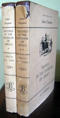
James Chapman Travels in the Interior of Africa 1849-1863 (Two Vols) Hunting and trading journeys from Natal to Walvis Bay and visits to Lake Ngami and Victoria Falls. Edited from the original manuscript by Edward Tabler. Map, photographs and ills. Dust jackets are worn with tears and pieces missing. Inscription to previous owner on ffep of both vols. Good Cape Town A.A. Balkema 1971 Reserve: $60 Click here to view further details and to bid

Sir Harry Hamilton Johnston, G.C.M.G.,K.C.B.,D.Sc. George Grenfell and the Congo, 2 Volumes 170 x 240mm Two volumes, GEORGE GRENFELL AND THE CONGO. A History and Description of the Congo Independent State and Adjoining Districts of Congoland Together With Some Account of the Native Peoples and Their Languages, the Fauna and Flora; And Similar Notes on the Cameroons and the Island of Fernando Po. The Whole Founded on the Diaries and Researches of the Late Rev. George Grenfell, with 496 illustrations from photographs by the Rev. George Grenfell and William Forfitt, 496 photographic illustrations, maps, sketch-maps, sketch-surveys,concessions map, including map showing distribution of Congo pygmies and map showing Stanley`s general geography of the Congo basin in 1885, fold-out maps attached to back of each volume, 990 pages in all, volume one, xxiii, 496 pages, volume two,xx, 497 pages, volumes are ex- central reference library stock (never lent out), condition: very good. George Grenfell was a Baptist missionary to Cameroon, and explored the little known rivers, notably the Wouri River and ascended `Mongo ma Loba` Mountain. He established a chain of missions at Musuko, Vivi, Isangila, Manyanga, and explored the Congo to the equator. He explored the Kiva, the Kwango, and the Kasai rivers, discovered the Ruki. He also explored other tributaries of the Congo and was awarded the Medal of the Royal Geographical Society for his map of the Congo Basin.The author, Sir Henry `Harry` Hamilton Johnston, was an explorer, botanist, linguist and colonial administrator and one of the key players in the `Scramble for Africa`. very good London Hutchinson and Co. 1908 Reserve: $100 Click here to view further details and to bid

various Lot of 9 books: 8 x Rhodesiana Government Financial Reports + The Political Economy of Rhodesia All eight of the government financial reports have been bound together into volumes of like reports, cased in hardcover rexine over board - all in very good bindings. 1.FEDERATION of RHODESIA and NYASALAND ECONOMIC REPORTS 1956-1963: [1956 - 85pp + map; 1957-72pp; 1958-missing; 1959-78pp; 1960-90pp; 1961-114pp; 1962-107pp; 1963-95pp] 2.RHODESIA FINANCIAL STATEMENTS 1970 & 1971 presented to the House of Assembly by the Minister of Finance [1970-58pp; 1970-54pp]. 3. SOUTHERN RHODESIA FINANCIAL STATEMENTS 1961-1969 presented to the Legislative Assembly. Some issues contain marginalia. [1961-62 24pp; 1962-63 23pp; 1963-64 33pp; 1964-65 69pp; 1965-66 now referred to as Rhodesia 67pp; Financial Statements presented to Parliament: 1966 65pp; 1967 55pp; 1968 52pp; 1969 68pp]. 4. REVIEW of the ECONOMY of SOUTHERN RHODESIA pesented to the Legislative Assenbly/Parliament 1961-68. [1961, 34pp; 1962, 33pp; 1963, 35pp; 1964 missing; 1965, 61[[; 1966, 30pp; 1967, 22pp; 1968, 28pp] 5. BANK of RHODESIA and NYASALND ANNUAL REPORT 1961-1964 [1961, 64PP; 1962, 47PP; 1963, 47PP; 1964, 69PP] 6. federation OF rhodesia AND nyasaland financial statements 1959-63 [1959-60, 20pp; 1960-61, 20pp; 1961-62 missing; 1962-63, 35pp; 1963-64, 40pp] 7. RHODESIA BUDGET STATEMENT 1965-69 presented by the Minister of Finance. [1965, 19pp; 1966, 27pp; 1967, 27pp; 1968, 27pp; 1969, 22pp]. 8. FEDERAL QUARTERLY BULLETEIN for the common monetary area of Northern Rhodesia, Malawi and Southern Rhodesia. Covers six quarters from October 1963 to January 1965 with 406pp in total. The quaters have been bound out of chronological sequence. 9. The Political Economy of Rhodesia; Auth G Arrighi; Publ Mouton, The Hague, 59pp with dj in good condition, a tad of edge frittering and shelf shadow to back panel. ALL OF THE FOLLOWING have multiple copies of the same genera reports bound into a single volume, presented in rexine over board with gilt spine titling. Occasional marginalia. Very Good Rhodesia/The Hague (1 book) Government Printer + Mouton (1 book) Various Reserve: $60 Click here to view further details and to bid

Various David Livingstone, Lot of 3 titles (1) David Livingstone, his Labours and his Legacy; Montefiore, Arthur; London, S.W. Partridge & Co. 13x19cm, Hard cover, blue decorated cloth, gilt titling, pp. 160 + (24) publisher`s advertisements. Pages yellowing, shelf wear to boards. Good. (2) Livingstone`s Anecdotes. A Sketch of the Career and Illustrations of the Character of David Livingstone, Missionary, Traveller, Philantropist. Macaulay, Dr. London, The Religious Track Society, c1874. 12x17.5cm, hard cover, illustrated brown cloth, gilt decoration and titling, pp. 135 + (8) advertisements. Boards worn, one third loss to spine, there is a whole in the first three leaves, inscription and stamp on first leaf, pages yellowing, foxing througout. A Fair copy. (3) The Livingstone Touch, Birkinshaw, Philip. 1973. Cape Town, Purnell. Hard cover, 18x26cm, cloth with gilt on spine, some b&w illustrations, map, pp. 10 + 182. Shelf-cocked, shelf wear to DJ, internally bright and clean. A Good copy. Various Reserve: $50 Click here to view further details and to bid

Various Africa Exploration and History (4 titles) (1) Narrative of an Exploratory Tour. Arbousset (T.) & Daumas (F.); C Struik, Cape Town, 1968. To the North-East of the Colony of the Cape of Good Hope. Facsimile reprint, Africana Collectanea Series No. XXVII: 330 pages, frontispiece, folding map, 10 illustrations, brown vynide, light foxing to extremities, end papers yellowing, dust jacket shelf worn with small tears, else Very Good. (2) Missionary Heroes of Africa; Stock, Sarah Geraldina, London, London Missionary Society, 1897, 180x218mm, With 75 illustrations and a map, Hard back, decorated cloth, pp. viii + 204 + advertisements. Spine area a bit sun faded, light foxing on end papers, otherwise very good internally, covers and binding fair. Presentation plate on flep: `Presented to James Riley, by the London Missionary Society, for collecting the sum of 6/6 for the New Year Offering of Ships, January, 1898 in Connection with Adelphi Chapel Sunday School`. (3) The Portuguese Pioneers, Edgar Prestage; A. & C. Black Ltd, 1933, First Edition, Hardcover, 15x22.5cm, pp. xiv + fold-out maps + 352. Blue cloth with gilt on front and spine, first and last two leafs sun-faded, internally very good, binding very good, inscription and stamp on flep, dj in poor condition. (4) The African Past, Chronicles from Antiquity to Modern Times; Davidson, David. Longmans, New York, 1964; First Edition. Hardcover, 8vo, pp. 392. A Good copy in a Good DJ. Various Reserve: $60 Click here to view further details and to bid

Various Cape of Good Hope Colonial History: Lot of 8 Titles (1) Cape of Good Hope Official Handbook 1886; Noble, John (ed); Printed and Published for the Colonial & Indian Exhibition by saul Solomon & Co, Cape Town, 1886. Hard cover, 15x22cm, colour maps, pp. 330 + advertisements. Rear board detatched, spine missing, title page creased, one map lose, inscription on flep and title page. Poor/binding copy. (2) The Old Cape House: Being Pages From History of a Legislative Assembly; Kilpin, Raplh; Maskew Miller; Cape Town, 1918, First Edition. pp. xiii + 200, 30 illustrations. Hard cover, 17.5x21.5cm, Hard cover, cloth spine with paper covered boards. Previous owner`s name on flep, title fading on spine which has discolored a bit, board corners bumped, else Very Good. (3) The Political Philosophy of J. A. de Mist, Commissioner-General at the Cape 1803-1805. A Study in Political Pluralism; Murray, A. H.; HAUM, Cape Town, c1962. Hard cover, grey cloth, 19x25cm. End papers tanned, usual shelf-wear to boards, inscription on flep, pen markings on a number of pages. Fair-Good. (4) The Memoirs of Kohler of the K.W.V.; Joelson, Annette; Hurst & Blackett/Unie Volkspers. 1946, Red cloth boards. pp. 128, illustrated, 14.5x22cm, Ex-libris I & FW Hosken plate pasted to inside front. Flep missing, boards age toned, pages yellowing. Fair-Good. (5) Those in Bondage; De Kock, Victor; `An Account of the Life of the Slave at the cape in the days of the Dutch East India Company`. George Allen & Unwin, London, hard cover, 14x22cm, pp. 240, illustrations. The cloth boards are worn, sunned, tears to spine, Fair. (6) Lords of Stalplein; Picard, Hymen W. J.; HAUM, Cape Town, 1974. Hard cover, 19x25cm, pp.176, illustrated with b&w plates. Text pages clean, lower edges of boards rubbed, DJ torn at spine ends and corners with some loss, Good. (7) Plantagenet in South Africa, Lord Charles Somerset; Millar, Anthony Kendal. Oxford University Press, South Africa, 1965. pp. 8 + 293, illustrated with b&w photographs. Hard cover, 14.5x22cm. End papers dirty and heavily foxed, inscription on flep and ink marks elsewhere, pages yellowing. Fair. (8) No Wine For The Governor, Lock, N. K.; Howard Timmins, Cape Town. Hard cover, cloth, 16.5x20.5cm, pp. iii + 241. Historical novel set in South Africa during the Governorship of Willem Adriaan van der Stel. Shelf-cocked, shaken, spine ends torn, wear to boards, stamp on inside front. Poor. Various Reserve: $50 Click here to view further details and to bid

Pinto, Maj. Serpa How I Crossed Africa from the Atlantic to the Indian Ocean 15x22cm This book,(translated into English by Alfred Elwes), details the travels of discovery by Maj. Pinto in two octavo (150 x 220mm) volumes half bound in library bindings of red leather and marbled boards; with the usual library stamps etc. in the front of both volumes. Vol. 1: 24 preliminary and 377 pages of text; Vol. 2: seven preliminary pages plus 388 pages of text. many engraved ills & maps. The books, which are ex library, were acquired in a completely tattered bindings and have been professionally restored, with the usual library numbers removed from the spines. A map showing Maj Pinto’s journey has been bound in as frontispiece and a large map showing “Tropical South Africa” was bound in at the back of the volume (both as received). In 1877, Serpa Pinto and the naval captains Capelo and Ivens were sent by the Portuguese government to explore the unknown tributaries of the Zambesi and inland Central Africa. They left Benguela in November. Soon after their departure, however, they parted company, Capello and Ivens turning northward whilst Serpa Pinto continued eastward. He crossed the Cuando (Kwando) river in June 1878 and in August reached Lealui, the Barotse capital on the Zambezi. There he received assistance from the missionary Franois Coillard, enabling him to continue his journey along the Zambezi to the Victoria Falls. He then turned south and arrived at Pretoria in northern South Africa on February 12, 1879. Serpa Pinto was the fourth explorer to cross Africa from west to east, and the first to lay down a reasonably accurate route between Biz (in present-day Angola) and Lealui. In 1881 the Royal Geographical Society awarded him their Founder`s Medal, `for his journey across Africa, during which he explored five hundred miles of new country` Good London Sampson Low, Marston, Searle & Rivington 1888 Reserve: $400 Click here to view further details and to bid


Miscellaneous items including Ivory Fan (waf), leather pouch containing prayer beads, miniature prayer book, a coin commemorating the `The Universal Exhibition of London` 1852, foreign bank dates, and four sovereigns commemorating the Marriage of the Prince of Wales to Lady Diana Spencer and an Admiralty Ordinance Survey Map nr 282.

A Great Western Railway Map with engineering plans for the Neptune, the Avenger, Marlin, Globe Master, Flashlight, Starfire, Fury, Cougar, Sky Warrior etc. aeroplanes dated 1953 and 1954, a road map of the British Isles, an engineering drawings of Viking ships and a leather suitcase with passenger lists, programmes, news cuttings for The White Star and Cunard and the QE II ships.


New Zealand1909-26 Dominion 1d. mint selection (13) including 1925 (Apr.) De La Rue unsurfaced paper and surfaced paper imperforate pair, and 925 (Aug.) Cowan paper imperforate pair; also 1923-25 Map 1d. (2); generally fine Subject to 20% VAT on Buyer’s Premium. For more information please view Terms and Conditions for Buyers.

Falkland Islands1937 Coronation, 1938 ½d. to £1 set of sixteen, 1946 Victory and 1948 Wedding, and Dependencies 1944-45 ½d. to 1/- set of thirty-two, 1946-49 thin map ½d. to 1/- and thick map ½d. to 1/-, 1946 Victory and 1948 Wedding, fine mint. Subject to 20% VAT on Buyer’s Premium. For more information please view Terms and Conditions for Buyers.


(x) India1957-58 Map of India Issue2n.p. light brown block of twenty (10x2) from the foot of the sheet with full sheet margins, the right-hand vertical pair failing to print due to dry print with the adjacent vertical pair also showing part of the design missing, mint; some vertical folds between columns. An impressive multiple, Photo Subject to 5% tax on Hammer Price in addition to 20% VAT on Buyer’s Premium. For more information please view Terms and Conditions for Buyers.

(x) India1957-58 Map of India Issue8n.p. perforated colour trials (3) in light brown, deep blue and light blue-green (the issued colour), each in a horizontal pair on gummed Star watermarked paper. Fine and scarce. Photo Subject to 5% tax on Hammer Price in addition to 20% VAT on Buyer’s Premium. For more information please view Terms and Conditions for Buyers.

(x) India1958-63 Map of India Issue1n.p. blue-green horizontal row of nine, and adjoining stamp at right, from the foot of the sheet with full sheet margins and "arrows", variety imperforate, fine mint. A fine and very rare positional multiple of this variety. S.G. 399a, £3,500+. Photo Subject to 5% tax on Hammer Price in addition to 20% VAT on Buyer’s Premium. For more information please view Terms and Conditions for Buyers.

(x) India1958-63 Map of India Issue10n.p. marginal blocks of four (2), 15n.p. pair, 20p. row of nine and 25n.p. corner pair, all showing "doctor blade" line, 20n.p. marginal strip of three showing blotchy light print, 20n.p. corner block of four showing blue printing in margins at base of lower pair and 50n.p. row of nine with stamp four showing most of design missing due to dry print and three adjoining stamp variously affected Subject to 5% tax on Hammer Price in addition to 20% VAT on Buyer’s Premium. For more information please view Terms and Conditions for Buyers.

(x) India1958-63 Map of India Issue10n.p. deep dull green horizontal pair, variety imperforate, neatly cancelled by large part 1960 c.d.s. Unknown unused and very rare used with few examples recorded. S.G. 405a, unpriced. Photo Subject to 5% tax on Hammer Price in addition to 20% VAT on Buyer’s Premium. For more information please view Terms and Conditions for Buyers.

A foldout colour map of London, produced by C Smith & Son, number 172 Strand, London 1849 complete with a slip case, also a further foldout map of "London and Westminster in the reign of Queen Elizabeth 1563", published by J Wallace 16 Ludgate Street London 1789, complete with slip case, further foldout map entitled Bacon's Map of South Eastern and Central England and a copy of Duckham's Motor Map of England and Wales dated 1910 (4) (illustrated)


1875-1950 ca., a valuable lot comprising of hundreds of covers, including several foreign destinations, early airmail issues, better semi-modern issues, occupation of China, illustrated postcards including Russo-Japanese War, Japan used in Taiwan, FDC's, postal stationery cards, cancellations with rare Takazaki cork cancels, numerous sports issues, other highlights being: 1909 combination cover with G.B., attractive set of 10 franked covers with delightful watercolour illustrations, 1910 illustrated envelope of the "Japan Mail Steamship Co." with world-map, etc. Also few National Parks souvenir sheets. An accurate viewing is required for this interesting and valuable lot.


-
109198 item(s)/page