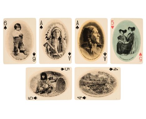

* American Playing Cards. The Great Southwest Souvenir Playing Cards, Kansas City, Missouri: Fred Harvey, 1910, 54 colour-printed cards, comprising 4 suits of 13 (French suits), each with pips 1-10 and 3 court cards, all with oval photographs of native American Indians, buildings, and views, indices to opposing corners, plus map card and joker (latter with small finger crease), illustration of mounted Indians on versos, rounded corners, gilt edges, 88 x 63 mm, contained in original turquoise cloth box, outer sleeve gilt lettered on one side (rubbed) and with mounted playing card on the other, somewhat soiled and worn, remains of tax stamp (for 1919), together with:New York City and Hudson River Souvenir Playing Cards, New York and San Francisco: Edward H. Mitchell, 1901, 54 colour-printed cards, comprising 4 suits of 13 (French suits), each with pip cards 1-10 and 3 court cards, all with oval scenic view, plus map card and joker, versos with full-length image of Father Knickerbocker in tricorn hat, rounded corners, gilt edges (rubbed), a few corners creased, king of spades with 6 mm closed tear in lower edge, 88 x 62 mm, contained in original cardboard box, outer sleeve gilt lettered on one side and with mounted playing card on the other (rubbed and with one side missing), plus 7 other US playing card items, comprising: The Stage, 1903, lacking joker, box broken with loss; Souvenir of Boston, 1900, box with some loss; California Souvenir, 1900, without box; Southern Pacific Lines, 1945, with booklet and box; Lyndy, the New Flying Game, 1927, with rules, box marked and worn; Poker Patience travelling folding set in slipcase with 1 deck Little Duke No. 24 cards and rule booklet (covers edge-frayed and detached); and 2 further packs of Little Duke cards, each boxed, housed together in cloth box lettered 'Patience' in gilt to hinged lidQTY: (9)NOTE:Hochman, The Encyclopedia of American Playing Cards, S27 & S38.
We found 108737 price guide item(s) matching your search
There are 108737 lots that match your search criteria. Subscribe now to get instant access to the full price guide service.
Click here to subscribe- List
- Grid
-
108737 item(s)/page

Shackleton (Ernest). South. The Story of Shackleton's Last Expedition 1914-1917, 1st edition, London: William Heinemann, 1919, colour frontispiece, half-tone illustrations, folding map (small closed marginal tear), bound without errata slip, usual toning to textblock, contemporary presentation inscription to front endpaper, previous owner signature, original blue cloth blocked in silver, slight rippling to upper cover, joints and edges slightly rubbed, 8voQTY: (1)
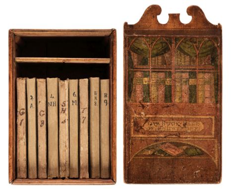
Wallis (John, publisher). The Book-Case of Knowledge, 1800, 9 (of 10) miniature volumes (lacking British Heroism), comprising: Short and easy Rules for Attaining a Knowledge of English Grammar (engraved frontispiece); A Compendium of Simple Arithmetic (engraved frontispiece); Geography and Astronomy Familiarized for Youth of Both Sexes (hand-coloured double-hemisphere map frontispiece, lacking uncoloured plate); A Natural History of Birds and Beasts (16 engraved plates, 2 cropped at fore-edge, 2 creased); Scripture History (engraved frontispiece adhered as front pastedown); Mythology, or, Fabulous Histories of the Heathen Deities (engraved frontispiece); Rewards for Attentive Studies (engraved frontispiece); The History of England, from the Conquest to the Death of George II (engraved frontispiece and 31 hand-coloured circular portraits on letterpress, one with tiny central hole); A Familiar Introduction to Botany (five hand-coloured engraved plates), three with half-title, generally light spotting, some toning (mainly associated with plates), Grammer with scarce finger-soilling, and with early ink manuscript ownership name to top edge of title, Botany final leaf (with previous closed tear) sometime laid down onto free endpaper, Scripture History stitching strained, most hinges cracked (3 detached), later plain boards, 5 sometime rebacked with paper (2 now split), Natural History nearly detached from cover, 3 joints cracking, rubbing and minor wear to some spines, each book approximately 96 x 57 mm, contained together in original pink paper-lined wooden box (previously repaired upside-down) with sliding lid, with shelf but lacking drawer, rubbed and marked, rear panel (split) with remnants of contemporary bookseller's (?) label, sliding lid with hand-coloured and varnished pictorial label (rubbed and darkened with some wear), the box 168 x 99 x 74 mmQTY: (1)NOTE:Alderson, Miniature Libraries for the Young, 4; Gumuchian 801 (dated 1801); Moon, John Harris's Books for Youth, 57 (dated 1803).
Speke (John). Journal of the Discovery of the Source of the Nile, 1st edition, London: William Blackwood & Sons, 1863, frontispiece, 25 plates, 46 illustrations in the text, 2 maps (one folding and loose), advertisements to rear, endpapers renewed, lightly spotted & dust-soiled, modern brown cloth gilt, 8vo, together with:Parke (Thomas Heazle). My Personal Experiences in Equatorial Africa as medical officer of the Emin Pasha Relief Expedition, 2nd edition, London: Sampson Low, Marston & Company, [1891], portrait frontispiece, 17 wood-engraved plates, folding map to rear pocket, lightly spotted & toned, hinges cracked, Holt Literary Society sticker to front pastedown, original pictorial cloth gilt, Holt Literary Society sticker to front cover, worn, 8vo, withThomson (Joseph). Through Masai Land: A Journey of Exploration Among the Snowclad Volcanic Mountains and Strange Tribes of Eastern Equatorial Africa, new and revised edition, London: Sampson Low, Marston & Company, circa 1890, wood-engraved frontispiece and illustrations, lightly spotted & toned, original red cloth gilt, lightly marked & rubbed, 8vo, with 2 others on AfricaQTY: (5)

Stackhouse (Thomas). An Universal Atlas Consisting of a Complete Set of Maps, to Illustrate Ancient and Modern Geography..., 6th edition Revised and Corrected, printed for S. J.Neele, circa 1800, printed title, dedication to George, Prince of Wales, list of subscribers, index and introduction, 40 maps, engraved by S. J. Neele, all with contemporary outline colouring, a few maps, with margins strengthened and repaired, the map of Denmark creased with repaired marginal closed tears, stained and laid on later paper, some water staining to the gutta, text block shaken with a few leaves loose and near detached, hinges with crude tape repairs, old boards with later marbled paper and 20th century half 'pin-head' cloth, bumped, worn and frayed, folio QTY: (1)
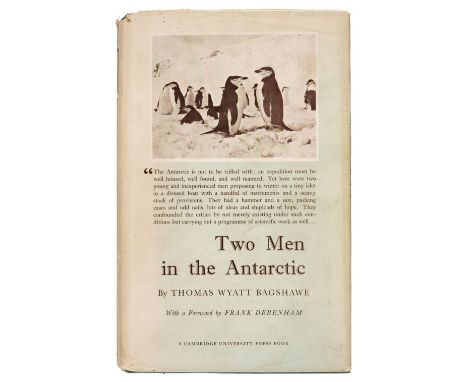
Bagshawe (Thomas Wyatt). Two Men in the Antarctic. An Expedition to Graham Land 1920-1922, 1st edition, London: CUP, 1939, folding panorama, half-tone illustrations, map endpapers, some light spotting, original cloth, slight dust-soiling to extremities, price-clipped dust jacket, spine a little faded with small stains, small chip and tear to rear panel, 8voQTY: (1)

Milne (A.A.) Winnie-the-Pooh, 1st edition, London: Methuen & Co., 1926, illustrations by E.H. Shepard, a few small stains, contemporary presentation inscription, map endpapers (slight partial offsetting), top edge gilt, original green cloth gilt, slightly rubbed at spine ends, slight lean, 8vo, together with When We Were Very Young, 6th edition, 1924 QTY: (2)

Baker (Samuel White). The Albert N'yanza, Great Basin of the Nile, and Explorations of the Nile sources, 1st edition, 2 volumes, London: MacMillan and Co, 1866, engraved portrait frontispiece to volume 1, tinted lithograph frontispiece to volume 2, 12 wood-engraved plates, 2 maps (1 folding), further illustrations to text, armorial bookplates of J Christopher Wilson to front pastedowns, large folding map with closed tear affecting image, lightly toned and spotted, front hinges cracked, contemporary half calf gilt over red marbled boards, green morocco labels, rubbed, 8vo, together with:Ismailïa, a narrative of the expedition to Central Africa for the suppression of the slave trade, 1st edition, 2 volumes, London: MacMillan and Co, 1874, 2 maps (1 folding), 51 wood-engraved plates, publisher's catalogue at end of volume I, original backstrip and front board laid onto endpapers in volume 1, ex-library with stamps to titles & further leaves, large folding map laid onto linen, lightly toned, modern half calf gilt over red marbled boards, morocco labels, 8vo, withAllen (William, T.R.H. Thomson). A Narrative of the expedition sent by Her Majesty's Government to the river Niger, in 1841, 1st edition, 2 volumes, London: Richard Bentley, 1848, 18 engraved plates (one folding), numerous illustrations in text, 3 maps (2 folding), several gatherings loose to volume 1, some toning, ex-library with stamps to title versos, original blue blindstamped cloth, rebacked, spines lettered in gilt, extremities rubbed, 8vo, with 20 others on AfricaQTY: (26)
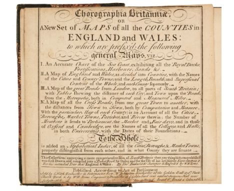
Badeslade (Thomas & William Henry Toms). Chorographia Britanniae. or A New Set of Maps of all the Counties in England and Wales, London, circa 1743, engraved double-page title, with the left-hand side laid on card, dedication with manuscript cancelled signature, 4 general maps of England & Wales and 3 sets of tables, 42 engraved maps, each with the county capital heightened in near-contemporary red watercolour, each map with a manuscript title to the verso and an additional four tables bound at rear, the map of Leicestershire creased and a little frayed, hinges and joints weak and cracked, later endpapers, 19th-century half morocco, worn and frayed, 8voQTY: (1)NOTE:Chubb CLXXIV.

Rackham (Arthur, J.M Barrie). Peter Pan in Kensington Gardens, 1st edition thus, London: Hodder & Stoughton, 1906, half-title, mounted frontispiece and 49 mounted colour plates by Rackham, captioned tissue guards, map to front free endpaper, contemporary ownership inscription to half-title upper margin, sporadic spotting, frontispiece loose, original red pictorial cloth gilt, 4to, together with:Rackham (Arthur, Washington Irving). Rip Van Winkle, 1st edition thus, London: William Heinemann, 1905, mounted colour frontispiece and 49 mounted colour plates by Rackham, captioned tissue guards, contemporary ownership inscription to front free endpaper, occasional spotting, original green pictorial cloth gilt, some wear, 4toQTY: (2)
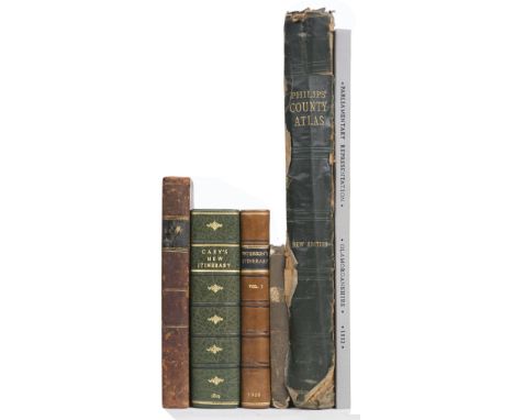
Lewis (William), Lewis's New Traveller's Guide, and Panorama of England and Wales. Containing Forty-Four Superior Maps, with all the direct and cross-roads, and objects of interest, and the distance of each principal place from London, including much information useful to all Travellers, London: William Lewis, 1836, engraved map frontispiece of England & Wales and 42 engraved maps (as called for, including maps of North & South Wales, map of Yorkshire folding), letterpress title dust and finger soiled with small tear, publishers cloth with printed label to the upper siding, worn and rubbed, small 8vo, together with Paterson (Captain Daniel). Paterson's British Itinerary..., volume 1 (only of 2), Bowles & Carver, 1800, calligraphic title page, engraved map frontispiece of England & Wales, 340 uncoloured engraved strip road maps, printed two to a page and back-to-back, contemporary calf, re-backed, worn at extremities, 8vo, with Cary (John). Cary's New Itinerary: or an Accurate Delineation of the Great Roads, Both Direct and Cross throughout England and Wales..., 8th edition, 1819, folding engraved map frontispiece of England and Wales, some splits to old folds, 6 uncoloured folding engraved regional maps, modern half morocco gilt, 8vo, plus Boys (John). General View of the Agriculture of the County of Kent ..., to which is added, a Treatise on Paring and Burning, 2nd edition,1805, folding map frontispiece with contemporary hand-colouring, slightly browned, folding table and two uncoloured engraved plates, bookplate of Baron Northwick, contemporary half calf, some wear, 8vo, and Dawson (Lt. Robert). Parliamentary Representation Glamorganshire, 1832, containing 12 engraved town plans, all with contemporary outline colouring, modern half cloth, slim upright folio, with George Philip & Son (publishers). Philip's Atlas of the Counties of England..., circa 1920, 48 (complete as list) double-page colour lithographic county maps, index bound at rear, publisher's gilt cloth, spine partially detached, heavily worn and frayed, folioQTY: (6)
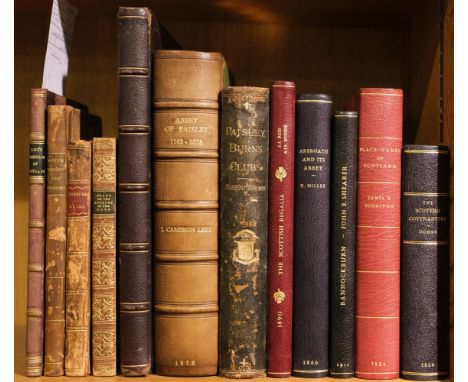
Loch (David). Essay on the Trade, Commerce, and Manufacture of Scotland, 1st edition, Edinburgh: Printed for the Author, 1775, vii,92pp., minor loss to extreme foot of title, authors manuscript presentation inscription to verso of title: 'Presented by the Author to John Henderson Esqr. as a small testimony of the Respect & Regard he has for Mr Henderson, a friend to his Country & promoter of its Manfctrs.', with additional inscription to verso of final leaf in the same (authors) hand 'The Reader will please excuse some errors in the Printing occasioned by the hurry of Publication', a few minor marks, bookplate of George William Mercer Henderson of Fordell and Peter M. Scott to front pastedown, later (late 19th century) plum half-calf, a little rubbed and minor marks, 8vo, together withA Proposal for Uniformity of Weights and Measures in Scotland, by execution of the laws now in force..., 2nd edition, Edinburgh: Printed for Peter Hill, 1789, vii,144pp., half-title present, additions and corrections to verso of page vii, additional unnumbered errata leaf at end, light spotting, modern bookplate of Peter N. Scott to front pastedown, contemporary half-calf, a little rubbed and scuffed, 8vo, plusA New Guide to the City of Edinburgh: containing a description of all the public buildings, and a concise history of the city, from the earliest periods to the present time, embellished with elegant engravings of the principal public buildings, 3rd edition, with considerable improvements, Edinburgh: Printed for, and sold by T. Brown, 1797, engraved frontispiece, folding engraved map, and 12 plates, modern bookplate of Peter M. Scott, contemporary tree calf, rubbed and some marks, small 8vo, and Stark (Rev. William). Considerations addressed to the Heritors and Kirk-sessions of Scotland, particularly of the border counties, on certain questions connected with the administration of the affairs of the poor, Edinburgh: Waugh & Innes, 1826, authors presentation copy, inscribed to front blank 'to the Lady Robert Manners, as a small expression of great respect and esteem, this little volume is presented, by Her Ladyship most obedient and very humble servant, The Author. Biel, 2 Octor 1826', modern bookplate of Peter M. Scott to front pastedown, marbled edges and endpapers, contemporary blind-decorated maroon full calf, gilt decorated spine, a little rubbed to joints, small 8vo, plus other Scottish interest including Cathcart W. Methven, Sketches of Greenock and its Harbours in 1886, Greenock, 1886 (good copy), J. Cameron Lease, the Abbey of Paisley, 1878, Robert Brown, Paisley Burns, Clubs, 1893, Reid and Brook, The Scottish Regalia, 1890, David Miller, Arbroath and its Abbey, 1860, John E. Shearer, Fact and Fiction in the story of Bannockburn, 2nd edition, 1911, James B. Johnston, Place-Names of Scotland, 1934 & James Dodds, The Fifty Year's Struggle fo the Scottish Covenanters, 1860, several volumes rebound in modern half-morocco by Maltby's of Oxford, mainly 8voQTY: (12)
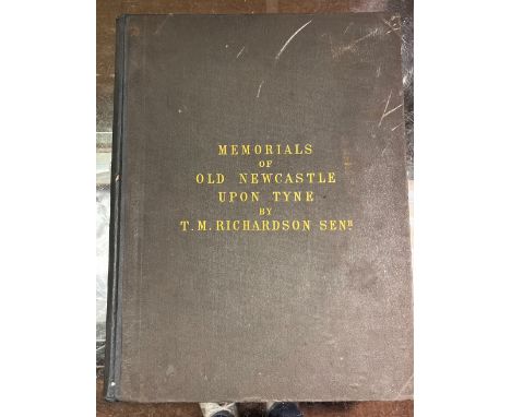
Richardson (Thomas Miles). Memorials of old Newcastle upon Tyne ... comprising forty etchings from original drawings of the towers, gateways, churches, streets and ancient buildings of Newcastle upon Tyne in the early part of the present century, nearly all of which have been removed, Edinburgh: Thos. Gray & Co.; Newcastle on Tyne: James Garland, [1880], lithograph title with signature J.H. Horsley to upper margin, 42 etched & engraved plates, occasional light spotting, original cloth, rebacked, few marks, folio, together with:Richardson (Thomas Miles), Antiquities of the Border Counties from original drawings by T. M. Richardson, Senr. with descriptive letterpress to which is added a reprint of Grey's Chorographia, Edinburgh: T. Gray & Co.; Newcastle on Tyne: J. Garland, 1881, lithograph portrait frontispiece, illustrated title and 20 mounted etched plates (two plates frayed to margins and detached), occasional light spotting and minor dust-soiling, all edges gilt, original cloth, light fraying to extremities, folio,Surtees (Robert). The History and Antiquities of the County Palatine of Durham, 4 volumes, facsimile reprint, Wakefield: E.P. Publishing, 1972, numerous monochrome illustrations, original cloth in dust jackets, folio, together with other facsimile reprints including Drake (Francis), Eboracum: or, the History and Antiquities of the City of York, facsimile reprint, Wakefield: E.P. Publishing, 1978, monochrome map & plates (some folding), illustrations, original cloth in dust jacket, folio, and Nicolson (Joseph & Burn, Richard), The History and Antiquities of the counties of Westmorland and Cumberland, 2 volumes, facsimile reprint, Wakefield: E.P. Publishing, 1976, two monochrome folding maps, original cloth in dust jackets, 4toQTY: (9)NOTE:Provenance: Sir William Whitfield CBE (1920-2019), one of the most significant British architects of the second half of the 20th century, notable for his ground-breaking designs for major public projects including Glasgow University Library, the Hunterian Art Gallery (1960-1968), Richmond House in Whitehall (1982-1984), recently selected as one of London’s ten most iconic Postmodern Buildings, Hereford Cathedral’s Mappa Mundi Library (1996), and Hawksmoor’s Baroque masterpiece Christ Church Spitalfields, slowly and carefully restored over three decades from 1970 to 2000 under his direction. He was Surveyor of the Fabric of St Paul’s Cathedral between 1985 and 1990.
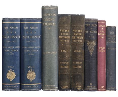
Belcher (Edward). Narrative of a Voyage round the World, performed in her Majesty's ship sulphur, during the years 1836-1842..., 1st edition, 2 volumes, London: Henry Colburn, 1843, 19 engraved plates, 2 folding maps (of 3), further illustrations to text, advertisements to rear of volume 1, marginal toning, a few spots, hinges repaired, original blue blindstamped cloth, rebacked with original spine laid on (some loss), rubbed, 8vo, together with:Pim (Bedford). The Gate of the Pacific, 1st edition, London: Lovell Reeve & Co, 1863, half-title, 7 engraved maps (2 folding), 9 lithographs (8 coloured including frontispiece), lightly spotted, original blue pictorial cloth gilt, rebacked with original spine laid on, rubbed, 8vo, withPrince Albert Victor and Prince George of Wales. The Cruise of Her Majesty's Ship "Bacchante" 1879-1882, compiled from the private journals, letters, and note-books ... with additions by John N. Dalton, 1st edition, 2 volumes, London: Macmillan and Co, 1886, folding map frontispiece to volume 1, black and white maps and illustrations throughout, lightly toned, original blue pictorial cloth gilt, rubbed and marked, 8vo, with 3 other travel volumesQTY: (8)
Smith (John Thomas). Ancient Topography of London; containing not only views of buildings, which in many instances no longer exist, and for the most part were never before published..., London: Published and sold by the proprietor, John Thomas Smith, 1815, additional hand-coloured etched title, 32 etched plates, some light toning, armorial bookplate of J.S. Hoare to upper pastedown, 19th-century half calf, rubbed and some wear, folio, together with:Campbell (E.C.), Scottish Scenery. Sketches from Nature, inscribed to the author of the "Pleasures of hope" by E.C. C., [Edinburgh: R.H. Nimmo et al., circa 1835], 47 lithograph plates and one hand-coloured lithograph map, some spotting, original cloth with printed paper title label to upper board (giving author as Mrs Robert Campbell), rubbed and some wear, oblong 4to,Godwin (George & Britton, John), The Churches of London: A history and description of the ecclesiastical edifices of the metropolis, 2 volumes, London: C. Tilt, 1838, engraved frontispiece to first volume and 58 plates, wood engraved illustrations to text, occasional scattered spotting, 20th-century half calf gilt, maroon morocco title labels to spines, 8voJones (Theophilus), A History of the County of Brecknock, 2 volumes in three, Breckmock: For the Author, 1805-09, engraved titles, folding maps, plans and numerous plates, some browning and spotting, armorial bookplate of Thomas Graham to upper pastedowns, edges untrimmed, original boards with later cloth spines, some wear, 4to, plus other British topography, 19th and 20th-century publications, including Grose (Francis), A Provincial Glossary; with a collection of local proverbs, and popular superstitions, new edition, corrected, London: Edward Jeffery, 1811; Biden (William Downing), The History and Antiquities of the Ancient and Royal Town of Kingston-upon-Thames, Kingston[-upon-Thames]: William Lindsey, 1852; View books, H. Besley's Views of Devonshire, [Exeter]: H. Besley, [1850?], Rock & Co., 30 Views of Tunbridge Wells, circa 1864; Six Views in Whitby, No.2, Whitby: S. Reed, circa 1860, etc. QTY: (approx. 35)
Golden Cockerel Press. A Voyage Round the World with Captain James Cook in H.M.S. Resolution, by Andrew Sparrman, introduction and notes by Owen Rutter, London: Golden Cockerel Press, 1944, wood-engravings by Peter Barker-Mill, folding facsimile map, occasional light spotting, top edge gilt, original green buckram gilt, lightly rubbed and marked, folio, 280 of 350 copiesQTY: (1)

Wallis (James). Wallis's New Pocket Edition of the English Counties or Travellers Companion in which are carefully laid down all the Direct & Cross Roads, Cities, Townes, Villages, Parks, Seats and Rivers with a General Map of England & Wales, published J. Wallis and sold by Davies & Eldridge, Exeter [1810], letterpress title cut with slight loss to the printed surface, contents list and forty-three (complete) engraved maps with contemporary hand colouring, including one double-page (Yorkshire), plus a small map of the Isle of Wight bound at rear (not called for by Chubb but usually present), very slight staining, contemporary half morocco gilt with red morocco gilt title label to the upper siding, bumped and worn at extremities, 8voQTY: (1)NOTE:Chubb. CCCXLIV.
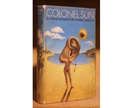
Amis (Kingsley, writing as Robert Markham). Colonel Sun. A James Bond Adventure, 1st edition, London: Jonathan Cape, 1968, a little light spotting at front, map endpapers, original cloth, dust jacket, spine slightly darkened and rubbed at head, marginal toning to flaps, 8vo, together with Fleming (Ian). Octopussy and the Living Daylights, 1st edition, London: Jonathan Cape, 1966, original cloth, dust jacket, price-clipped with later 80p net price sticker, 8vo QTY: (2)
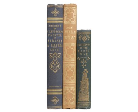
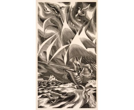
Lear (Edward). Journals of a Landscape Painter in Albania, &c., 1st edition, London: Richard Bentley, 1851, uncoloured lithographed single-page map frontispiece, 20 tinted lithograph plates, some very light spotting to plates only, contemporary ownership signature of J. R. Gilbert to head of title, front inner hinge a little shaken, original blind-stamped blue cloth, gilt spine, rubbed and some marks and light overall soiling, large 8vo, together withBartlett (W. H.). The Nile Boat; or Glimpses of the Land of Egypt, 1st edition, London: Arthur Hall, Virtue, and Co., 1849, engraved frontispiece, additional engraved vignette title page, single page engraved map, and 32 engraved plates, wood-engraved illustrations to text, 8pp. publishers advertisements at rear, original yellow chalk-glazed endpapers with printed advertisements, original gilt-decorated pale pink cloth, spine lightly faded (generally a very good copy), large 8vo, plusAlexander (Colonel Sir James E.). Incidents of the Maori War, New Zealand in 1860-61, 1st edition, London: Richard Bentley, 1863, tinted lithograph frontispiece view of New Plymouth, Taranaki, single-page engraved map, original yellow chalk-glaze endpapers, contemporary prize bookplate to front pastedown from Leek Commercial School, dated mid-summer 1869, gilt-decorated and blind-stamped green cloth, very lightly rubbed (generally in excellent condition), 8voQTY: (3)NOTE:Abbey Travel 45; Blackmer 986 (for the first work).
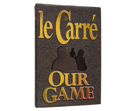
Le Carre (John). Our Game, 1st edition, London: Hodder & Stoughton, 1995, map endpapers, original cloth, dust jacket, tiny closed tear at head of spine, 8voQTY: (1)NOTE:Signed by the author to bookplate tipped-in at title. In the suppressed first issue dust jacket, subsequently changed for the second impression as the author disliked the design.


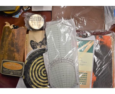
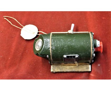
British and American Militaria lot including British Cold War era 1960s Dead Reckoning Computer Mark 4, ref no 6B/490, made by 'The London Name Plate MFG. Co. Ltd., of London and Brighton, American U.S. Army Air Corps Aerial Dead Cold War era 1960s Dead Reckoning Computer, contract No. AC-22841 Type E-68, Spec No. 94-27.892 made by Harry H. Knepper Inc with leather pouch made S.M. Co., Canada, American 1944 Computer, Altitude Correction (C-2 Type), Felsenthal, AN 5837-1, sadly missing its dial hands but in fair condition with wear, British WWII Anti Gas Eye shields MK II dated 1941 which are worn and a tin of Military Dubbing named 'Dubbing Protective No.1 - 2ozs. Nett' in unused condition and a Regesan Catarrh Pastilles tin, British WWII Booklet Ocean Front - The story of the War in the Pacific 1941-44 published by His Majesty's Stationery Office 1945, some pages have detached but it is complete and a scarce, Soviet Cold War era - What to do in a Nuclear Attack booklet, dated 1967 produced by the Dosaaf publishing house. Scarce Russian pamphlet and a British WWII Booklet 'The Battle of Egypt' prepared for the War Office 1943 8" - 9" tall; 32 pages; "The official record in pictures and map." 32p. chiefly photo-illus., map ; 35cm. Series: The Army at War. Subjects: World War, 1939-1945 -- Campaigns -- Egypt. World War, 1939-1945


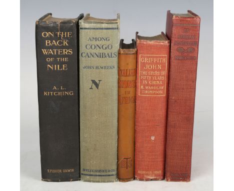
AFRICA. - A.L. KITCHLING. On the Backwaters of the Nile. London: T. Fisher Unwin, 1912. First edition, 8vo (218 x 140mm.) 56 photographic illustrations on 48 black and white plates, 1 folding map of 'The Uganda Project' to rear. (Toning, some light to moderate spotting.) Original brown cloth, pictorial gilt to upper cover, t.e.g. (extremities bumped). Provenance: H.R. Nelson (bookplate to the front pastedown). - And a further seventeen volumes, mainly relating to Africa (including John H. Weeks' 'Among Congo Cannibals', 1913, 8vo) (18).Buyer’s Premium 29.4% (including VAT @ 20%) of the hammer price. Lots purchased online via the-saleroom.com will attract an additional premium of 6% (including VAT @ 20%) of the hammer price.
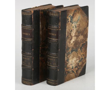
LONDON. - Sholto and Reuben PERCY. The Percy Histories, or Interesting Memorials of the Rise, Progress, & Present State of all the Capitals of Europe. London: for T. Boys, 1823. 2 vols., 24mo (133 x 81mm.) Folding engraved map of London by Benjamin Davies, engraved frontispieces of Somerset House and King George IV. (Toning, a 3-inch tear and a further 2-inch tear along the fold of the map, browning to titles, occasional spotting.) Near contemporary black half morocco over marbled paper-covered boards (light rubbing). Provenance: Lydia Monk (name inscribed to front-free endpaper). Note: the map shows London along the River Thames from Chelsea to the East India Docks and from Regents Park to Greenwich Park, showing all the streets, parks and important buildings (2).Buyer’s Premium 29.4% (including VAT @ 20%) of the hammer price. Lots purchased online via the-saleroom.com will attract an additional premium of 6% (including VAT @ 20%) of the hammer price.
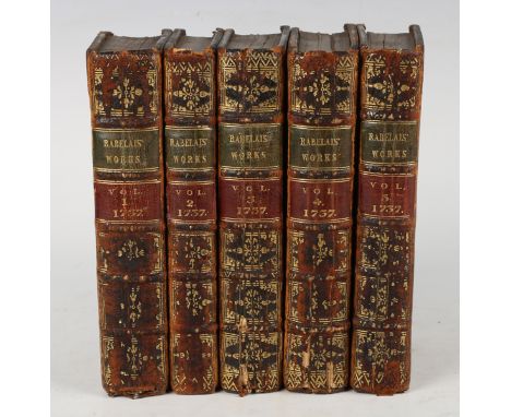
RABELAIS, Francis. The Works…Now carefully revised, and compared throughout with the late new Edition of M. Le du Chat, by Mr Ozell. London: J. Brindley and C. Corbett, 1737. 5 vols., first English Collected edition, 12mo (164 x 90mm.) 15 engraved plates, including 10 folding and 1 map, titles in red and black. (Browning throughout, occasional spotting, lacking blanks to vol. 1, corner cut to initial blank of vol. 2.) Near contemporary calf, later red and green morocco lettering pieces to the spines (spines rubbed with loss to gilt, some spine ends chipped). Provenance: Charles Western, Whig politician (name ink inscribed verso frontispiece of vol. 1.); Thomas Western, Liberal M.P. (bookplates to front pastedowns); R.F.W. Brandt (small stamps on front-free endpapers) (5).Buyer’s Premium 29.4% (including VAT @ 20%) of the hammer price. Lots purchased online via the-saleroom.com will attract an additional premium of 6% (including VAT @ 20%) of the hammer price.
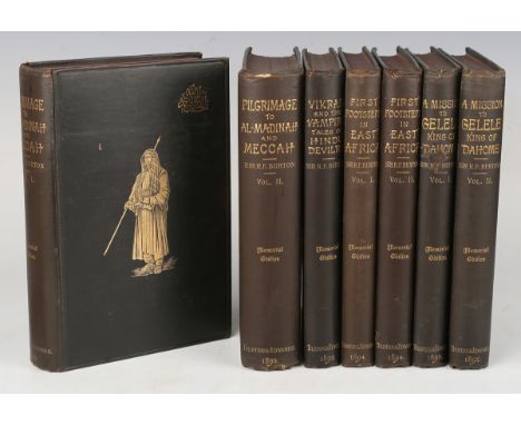
BURTON, Richard F. The Memorial Edition of the Works of Captain Sir Richard F. Burton. London: Tylston and Edwards, 1893-1894. 7 vols., 8vo (211 x 131mm.) 2 frontispieces, a folding map, 13 plates and 3 folding plans in 'A Pilgrimage to Al-Madinah & Meccah', 2 frontispieces to 'A Mission to Gelele, King of Dahome', 1 frontispiece to 'Vikran and the Vampire, or, Tales of Hindu Devilry', 2 frontispieces, 2 plates and 2 maps to 'First Footsteps in East Africa', 2 publisher's promotional slips. (Toning, corner crease to frontispiece of vol. 1 of 'A Mission to Gelele', occasional minor spotting to front and rear leaves.) Original black cloth, pictorial gilt to covers (minor rubbing, occasional scuffing or nicks to covers) (7).Buyer’s Premium 29.4% (including VAT @ 20%) of the hammer price. Lots purchased online via the-saleroom.com will attract an additional premium of 6% (including VAT @ 20%) of the hammer price.

BINDINGS. - James DUGDALE. The New British Traveller, or Modern Panorama of England and Wales. London: J. Robins & Co., 1819. 4 vols., 4to (262 x 230mm.) Engraved allegorical frontispiece, engraved vignettes to half-titles, 43 uncoloured engraved maps, 47 engraved plates, folding map of England & Wales, 1p. publisher's advertisements to rear. (Folding map heavily torn and creased, several leaves torn, marginal chipping and creasing with some repairs, occasional heavy spotting, browning.) Near contemporary Spanish calf, gilt lettering to spines (rubbing to extremities). Provenance: James Leach (name inscribed to initial blanks). - And a further twenty volumes (including G.N. Wright's 'Life and Campaigns of Arthur, Duke of Wellington, K.G.', 4 vols., [1841], 8vo, and James Stanier Clarke's and John M'Arthur's 'The Life and Services of Horatio Viscount Nelson', 3 vols., [1840], 8vo) (24).Buyer’s Premium 29.4% (including VAT @ 20%) of the hammer price. Lots purchased online via the-saleroom.com will attract an additional premium of 6% (including VAT @ 20%) of the hammer price.

BURTON, Richard F. The Gold-Mines of Midian and The Ruined Midianite Cities. A Fortnight's Tour in North-Western Arabia. London: C. Kegan Paul & Co., 1878. Second edition, 8vo (218 x 133mm.) Folding lithographed map of North-Western Arabia to rear, 1p. and 32pp. of publisher's advertisements to rear. (Toning, spotting to front and rear leaves.) Original red cloth blocked in black and gilt (extremities rubbed, small marks to lower cover). Provenance: Gregg Wilson (prize bookplate to front pastedown). - And two further volumes by Richard F. Burton ('Unexplored Syria', 2 vols., 1872, 8vo, lacking plates) (3).Buyer’s Premium 29.4% (including VAT @ 20%) of the hammer price. Lots purchased online via the-saleroom.com will attract an additional premium of 6% (including VAT @ 20%) of the hammer price.
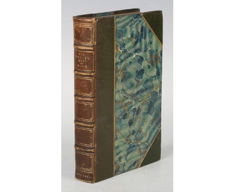
MOUNTAINEERING. - Alfred WILLS. 'The Eagle's Nest' in the Valley of Sixt; a Summer Home Among the Alps: Together With Some Excursions Among the Great Glaciers. London: Longman, Green et al., 1860. First edition, 8vo (192 x 117mm.) 2 folding engraved maps, 12 tinted lithographed plates. (Lacking publisher's advertisements to rear, toning, some creasing to one map.) Near contemporary green half morocco over marbled paper-covered boards, t.e.g. (browning to spine, extremities lightly rubbed). Note: Alfred Wills was an earlier pioneer in Alpine mountaineering and the third president of the Alpine Club. He was also the judge who sentenced Oscar Wilde to two years hard labour.Buyer’s Premium 29.4% (including VAT @ 20%) of the hammer price. Lots purchased online via the-saleroom.com will attract an additional premium of 6% (including VAT @ 20%) of the hammer price.

ICELAND. - George Webbe DASENT. The Story of Burnt Njal, or Life in Iceland at the End of the Tenth Century. Edinburgh: Edmonston and Douglas, 1861. 2 vols., first edition, 8vo (208 x 132mm.) Double-page lithographed map of Iceland as frontispiece to volume 1, 2 large folding maps at rear of volumes, and 5 further plates including 1 double-paged. (Spotting to preliminaries.) Original green cloth, decorative gilt (lightly rubbed) (2).Buyer’s Premium 29.4% (including VAT @ 20%) of the hammer price. Lots purchased online via the-saleroom.com will attract an additional premium of 6% (including VAT @ 20%) of the hammer price.

BURTON, Richard F. (translator). The Lands of Cazembe. Lacerda's Journey to Cazembe in 1798. London: John Murray, 1873. First edition, 8vo (213 x 125mm.) Folding lithographed map, hand-coloured in outline, index to rear. (Toning, blanks replaced.) Late 20th century black half morocco over grey cloth-covered boards, gilt lettering to spine (endpapers replaced). - And a further volume of the same work, bound in the same style, but over tan cloth-covered boards (2).Buyer’s Premium 29.4% (including VAT @ 20%) of the hammer price. Lots purchased online via the-saleroom.com will attract an additional premium of 6% (including VAT @ 20%) of the hammer price.


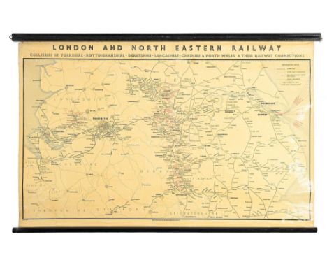
Railwayana. Wall map of LONDON AND NORTH EASTERN RAILWAY COLLERIES IN YORKSHIRE, NOTTINGHAMSHIRE, DERBYSHIRE, LANCASHIRE, CHESHIRE & NORTH WALES & THEIR RAILWAY CONNECTIONS, scale 4 miles to one inch, by George Philip & Son Ltd, c1920, varnished, backed on linen, black painted wood bar and roller Good condition

Books. 15 shelves of 19th century and later ex-library stock, all with their stamps, bookplates, &/or bindings, including Nicholson (William, illustrator), An Almanac of twelve Sports, London: William Heinemann, 1898, 12 plates as called for (repaired), institutional cloth and stamps, 4to, Lowe (Robert), General View of Agriculture of the County of Nottingham, with Observations on the Means of its Improvement, London: C. Macrae, 1794, lacking map, old repairs, institutional part-leather binding, 4to, 20th century agricultural interest, 19th century and later local interest, including Nicholson (Richard), The Abbey Church, Worksop, sole edition, Worksop: S. Sissons, 1850, full-page line engravings, blind stamped, original roan over titled papered boards, 19th century and later private bookplates, crown folio, Killpack (W.B.) & Clarke (T.H., illustrator), The History and Antiquities of the Collegiate Church of Southwell, London: Simpkin, Marshall, and Co., 1839, tipped-in plates, later calf over boards, crown folio, other 19th century and later books, pamphlets and monographs on antiquarian subjects, architecture, topography, etc; geology, agriculture, literature, the Church, etc.
![Robert Morden (c. 1650-1703) - The Kingdom of Ireland, [London]: Sold by Abel Swale, Awnsham and John Churchill, n.d. [18th c](https://cdn.globalauctionplatform.com/f5037d49-d67f-4020-a960-af6201139999/e8f6fe6c-c650-42b3-941e-af6300a572b6/468x382.jpg)
Robert Morden (c. 1650-1703) - The Kingdom of Ireland, [London]: Sold by Abel Swale, Awnsham and John Churchill, n.d. [18th century], two-page map, engraving, slightly later hand-colouring, 43 x 36cm, another, similar, Derbyshire, etc., (3). Ireland colouring faded/washed. Rippled surface, toned portions. Others generally good.

Railway Maps and Junction Diagrams, framed, 1952 BR diagram of Nailsea & Backwell junction, 131cm wide by 42cm high (P-F), the remainder framed and glazed, 1965 BR diagram of Beaulieu Rd junction 82cm wide by 45cm high, gradient map of Narroways Hill Junction to Pilning junction via Avonmouth 70cm wide by 20cm high, faded, track diagram Penrith to Derwent Junction faded 49cm wide by 15cm high and engraved map of Berkshire detailing railways and stations, 45 cm wide by 30cm high, P-E, (5)

Carriage Prints and Maps, all framed and glazed, Southern Railway General System Map in original frame, 68cm long by 28 cm high, together with three others all with trimmed borders in later frames, Travel in 1840, Travel in 1895, Travel in 1890, each 60cm wide by 20cm high, F-G, frames F, (4)


A 1940 petit point embroidery Estate Map - 'Itchen Stoke Manor 782 Acres Farmed and Owned by Hon Alexander Henry Baring JP', to/w a list of estate workers, within finely-worked border with Baring Crest, wild flowers, livestock and cups, signed AMB and dated 1940-49, 64 x 67 cm, in glazed oak frame (by Angela Baring)
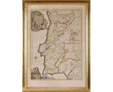
PRINT.- PORTUGAL.- Le Royaume de Portugal et des Algarves. Divisé en ses Archevêchés, Evêchés, et Territoires / par le Sr. Sanson...- A Paris: Chez H. Iaillot, 1695.- 1 gravura a talhe-doce; 775x563 mm (matriz); 880x630 mm (folha aparente)., Large map of Portugal (copperplate engraving, hand-coloured), by the French cartographer and historian Nicolas Sanson d’Abeville (1600-1667). It includes a large cartouche with the title and a smaller one with Latin text: Nova Regni Portugalliae et Algarbiae Descriptio Authore N. Sanson. Very fresh proof, with central crease, framed., moisture stains, creases, Dim. - (gravura) 75 x 55; (moldura) 99,5 x 74 cm

PRINT.- JAPÃO.- Iapponiae Noua & accurata descriptio Per R.P. Antonium Francisco Cardim Societatis IESV et Elogia Iapponica.- [Romae: Typis Heredum Corbelleti, 1646].- 1 gravura a talhe-doce; 278x408 mm (matriz), 320x435 mm (folha)., Engraving and etching map, not coloured, published in the work of Fr. cardim, “Fasciculus e Iapponicis floribus” (Rome, 1646). Father Cardim SJ (1596-1659), a Jesuit missionary, born in Viana do Alentejo, joined the Society of Jesus in 1611, having completed his studies in Goa. Cardim, was one of the great travelers in the East, chronicler of the Society of Jesus in China and Japan and attorney general of the province of Japan, ended his days in Macau, at the age of 63 after having lived 15 years between the two empires of the East. The print represents the diocese of Japan, with the implementation of schools, seminaries, hospitals, etc., making up the 36 points identified in the extensive caption; bottom left, a ship on the high seas, representing the arrival of St. Francis Xavier to Japan, on August 15, 1549. Slightly worn copy with some stains, left margin trimmed by the platemark; occasional minor restorations and weakened central fold. It is, however, complete and recoverable. Sommervogel, II, p. 740., Dim. - 31,5 x 43 cm
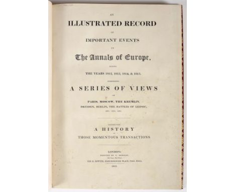
ILLUSTRATED (AN) record of important events in the annals of Europe, during the years 1812, 1813, 1814, & 1815. Comprising a series of views of Paris, Moscow, the Kremlin, Dresden, Berlin, the Battles of Leipsic, etc. etc. etc. Together with a history of those momentous transactions.- London: Printed by T. Bensley, for R. Bowyer, 1815.- 76, [28], 10 p.: il.; 43 cm. Junto com: CAMPAIGN (THE) of Waterloo, illustrated with engravings of Les Quatre Bras, La Belle Alliance, Hougoumont, La Haye Sainte, and other principal scenes of action...- London: Printed by T. Bensley and Son, for Robert Bowyer, 1816.- 34 p.: il.; 43 cm.- E., Large graphic edition, published following the defeat and capitulation of the French Army, sometimes attributed to Thomas Hartwell Horne (1780-1862), English theologian and librarian. The first part is illustrated with 18 hand-coloured watercolours (4 fold-outs) representing cities (Paris, Moscow, Hamburg, Amsterdam, etc.) and military forces, a map and five intaglio prints; the second includes four aquatints (1 fold-out) and a map. The five folding plates were cut by the folds and later recovered, but they are damaged; the remaining 17 aquatints are very clean, as are the maps and engravings. The plates with the facsimiles of the signatures (p. 76) with tear restored without lack of support. Recent binding, fully red shagreen with elaborate gold ornamental borders on the covers, closed panels on the spine (with an eagle between the raised bands) and rolls on the squares. Protective case. Abbey (Life), 352 and 354
-
108737 item(s)/page