We found 109182 price guide item(s) matching your search

Refine your search

Year

Filter by Price Range
  • List
  • Grid
  • 109182 item(s)
    /page

Lot 785

Giacomo Cantelli da Vignola (1643-1695), hand-coloured map - ‘Isole Dell India’, dated 1693, 45cm x 59cmCondition report: Replaced element top right corner, and right hand edge, some losses here, general deterioration to periphery, small tears, some tape repairs, time stains

Lot 726

Vicenzo Maria Coronelli (1650-1718), engraved map - ‘Siam o’ India’, 27cm x 43cm.Condition report: creases to top margin, time stains

Lot 799

Local interest map: Norfolk, Kings Lynn - 'Plan of the Eau Brink River and part of the River Ouse with the proposed New Bridge, Public Roads and Drains communicating therewith 1819' - Hand drawn coloured plan by Charles Barcham of Kings Lynn, showing land ownership and field boundaries, inscribed in pen to rear ‘River Ouse - Proposed Eau Brink Cut’, 79 x 130cm NB: William Elstobb and others had suggested that the great bend in the river above King's Lynn should be removed by creating a cut, but it took 50 years of arguing before the Eau Brink Act was obtained in 1795 to authorise it, and another 26 years until the cut was finally opened in 1821. During this time, most of the major civil engineers of the time had contributed their opinions. The original project head and chief engineer was Sir Thomas Hyde Page. The work was overseen by John Rennie and Thomas Telford and construction took four years. It proved to be too narrow, resulting in further silting of the harbour and was widened at an additional cost of £33,000 on Telford's advice. It is believed that the only other copy of this plan can be found in The National Archives.

Lot 750

Gulliaume de L’Isle (1675-1726), hand-coloured map - ‘Asia divisa in Imperial Regna & Status’ Covens & Mortier, 1730 49cm x 58cm.Condition report: patched to lower spline, small patch repair lower edge, small tear top of spine, creases top right corner and minor creases and marls elsewhere

Lot 794

Emanuel Bowen (1693-1767) hand coloured engraved map of Leistershire and Rutland, 54cm x 69cm, glazed frame

Lot 713

Guiljelmus Blaeu (1571-1638), hand-coloured map - ‘Asia Noviter Delineata’, 1630, with border vignettes of country types and scenes of ports, Dutch text verso, 38cm x 48cm.Condition report: spine has been strengthened and some tape repair, two central creases, a few small tears and creases to margins, water stain lower left corner, browning to periphery, some general creases, time stains and grubby marks but no severe condition issues

Lot 737

Jan Jansson (1596-1664), hand-coloured map - ‘Insularum Moluccarum’, 1656-1661, English text verso, 39cm x 50cm.Condition report: small burn hole lower left corner, tape arresting two tears from top edge, otherwise just minor time stains, creases

Lot 770

Abraham Ortelius (1527-1598) engraved map - ‘Asiae Nova Descriptio’, circa 1570, 38cm x 50cm.Condition report: Browning to periphery, some time staining, foxing marks

Lot 729

Pierre Du Val (1618-1683), hand-coloured map - ‘L’ Asie’, dated 1663, 41cm x 53cm.Condition report: Minor stains, creasing, generally good condition

Lot 748

Thomas Kitchin (1718-1784), hand-coloured map - ‘Asia and its several Islands and Regions according to their most approved divisions, with Captain Cook’s New Discoveries, published Laurie & Whittle, London 1794, 45cm x 55cmCondition report: Patch repair to top of spine, some grubby marks and ink spots top right otherwise generally good
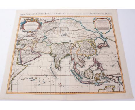
Lot 795

Christopher Saxton & William Kip , hand-coloured engraved map - ‘Suffolciae’, circa 1637, 27.5 x 37.5cm, glazed frame

Lot 710

Carel Allard (1648-1709), hand-coloured map - ‘Exactissima Asiae Delineatio...’ after Nicolas Witsen, 50cm x 60cm.Condition report: Top margin trimmed to plate edge, some small losses and tears two margins, tape repairs lower right corner, lower left corner, image good colours bright

Lot 736

Jan Jansson (1596-1664), hand-coloured map - ‘Indiae Orientalis Nova de Scriptio’, 1639, French text verso, 39cm x 51cmCondition report: Repair and large losses to margins lower left lower right although intact within plates generally some timestaining

Lot 703

Jodocus Hondius (1563-1612), hand-coloured map - ‘Asiae Nova Decsriptio Auctore’, 1606, 37cm x 50cm, framed.Condition report: Glazed frame, not examined out of frame, small margin exposed, Map appears to be in good condition, colour faded.

Lot 782

John Senex (d.1740), large hand-coloured map - ‘Asia’ - dedicated to Sir George Markham Baronet, 1714, 68cm x 96cmCondition report: tape repairs to margins and seams, general creases, image mostly good

Lot 730

Pierre Du Val (1618-1683), hand-coloured map - ‘Carte des Indes Orientales’, dated 1665, 39cm x 54cm.Condition report: Patch and a little detail infilled to a great/loss at top of spine, condition otherwise good.

Lot 701

John Speed (1552-1629), hand-coloured map - ‘Suffolke’, sold by Bassett, circa 1610, with amorials of the Dukes and Earls of Clare and Suffolk, vignette map of Ipswich, 39cm x 52cm, in glazed frameCondition report: not examined out of the frame, mounted up to edge of image and no margins visible. However appears to be in good condition

Lot 700

John Speed (1552-1629), hand-coloured map - ‘Essex’, circa 1610, after John Nordon, sold by Bassett, with heraldic shields of the Earls of Essex and Colchester vignette map, 39cm x 52cm, in glazed frameCondition report: Glazed frame and not examined out of frame, mounted to edge and no margins exposed, slight deterioration bottom right corner, minor creases otherwise ok.
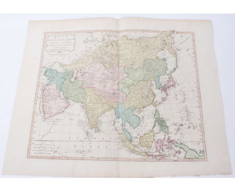
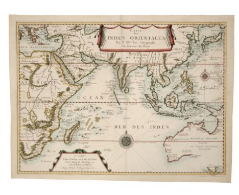
Lot 732

Giacomo Gastaldi (c. 1500-1540), engraved map - ‘India Tercera Nvova Tavola’, 1562 (Girolamo Ruscelli’s Geographia), Latin text verso, 20cm x 26cm.Condition report: Slight splits to spine, two patches to top edge arresting tears, a little time-staining, otherwise ok

Lot 763

Herman Moll (d. 1732), large hand-coloured map -‘A map of East Indies.... to Ye Directors of Ye Hon.ble United East-India Company’, 1717, 62cm x 101cm.Condition report: Some tape to edges and creases arresting tears, creasing and minor stains, generally good

Lot 777

Pieter Schenk (1645-1715), hand-coloured map - ‘Asiae in Tabula Geographica Delineatio’, 1700, 52cm x 58cm.Condition report: couple of tape repairs to spine and margins addressing tears, minor stains but image is generally good

Lot 709

Pierre van der Aa (1659-1733), engraved map - ‘Les Indes Orientales’, 29cm x 34cm, 1714, together with eight further small Far Eastern maps by the same cartographer, several coloured, including ‘La Rade de Batavia’, ‘De Moluccos’, ‘L’Ile de Sumatra’, ‘Carte des Isles Phillippines Celebes et Moluques’, ‘Le Detroit de Malacca’, ‘ L’Ile de Borneo’, ‘Les Iles de Banda’, ‘Les Base de Manille’. (9)Condition report: minor disrepair, generally good order

Lot 735

Henricus Hondius (1597-1651), hand-coloured map - ‘Asia’ 1641, published Jan. Jansson, Amsterdam, Latin text verso, 37cm x 49cmCondition report: Significant time staining, browning at periphery

Lot 774

Nicolas Sanson (1600-1667), hand-coloured map - ‘Asia Vetus’, dated 1667, 41cm x 57cmCondition report: A few stains to margins, minor creases

Lot 769

Abraham Ortelius (1527-1598), engraved map - ‘Erythraei Sive Rubri Maris Periplus’, 1597, Latin text verso, 37cm x 48cm.Condition report: Pin hole top left corner of margin, minor time stains generally good

Lot 779

John Speed (1552-1629), hand-coloured map - ‘A new map of East India’, 1676, English text verso, 39cm x 49cm.Condition report: Generally good condition

Lot 724

Henry Abraham Chatelain (1684-1743), hand-coloured map - ‘Carte de L’ Isle de Java’, accompanying text and vignette map ‘Le Port de Batavia’, 1719, 39cm x 88cm.Condition report: Minor time stains and creases

Lot 244

An Alderney Ordnance Survey map - revised from Air photographs Jan 1943 mounted.

Lot 402

A 17TH CENTURY MICHAEL DRAYTON ENGRAVED UNCOLOURED MAP OF SURREY AND SUSSEX, circa 1612, with allegorical figures, 25cm x 33cm, framed and glazed

Lot 412

A 17TH CENTURY MAP OF STAFFORDSHIRE BY MICHAEL DRAYTON, with allegorical figures, hand tinted, unmounted and unframed, 28.5cm x 35cm, together with ten county maps of Staffordshire including Blome, Cary and Greenwood and a tinted engraving of Shugborough (12)

Lot 535

ADAM BARSBY (BRITISH CONTEMPORARY) 'THE WAY HOME', a giant white horse standing over a small boy with a map, signed and titled to the lower margin, mounted, framed and glazed, approximate size 102cm x 49cm (condition:- framed damaged) (A)

Lot 344

THE CHILWELL (NOTTS) ESTATE FOLDING MAP, circa 1885, 80sq inch panels

Lot 407

WARWICKSHIRE, a collection of fifteen unframed 18th and 19th Century maps, including 'An Accurate Map of the County of Warwick divided into its hundreds collected from the best materials Agreeable to Sr WM Dugdale..... Engraved by Thos. Jefferys', hand tinted, 63cm x 51cm and 'A New and Accurate Map of Warwickshire drawn from the best surveys and intelligence divided into its Hundreds.... By Thos. Kitchin', hand tinted, 80cm x 63cm (15)

Lot 405

A LATE 18TH CENTURY FOLDED MAP BY J. MENZIES, 'A Correct Map of England With all The Principal and Cross Roads', published by Thomas Brown, Edinburgh 1792, paper backed on coarse linen, 51cm x 45cm, together with Bacon's Cycling Road Map of England and Wales, sheet No.2, printed on linen, 63cm x 85cm, a mid 18th Century Nicolao Sanson hand coloured map 'Britannicae Insulae', 52cm x 61cm and other unframed maps of the British Isles, etc (7)

Lot 645

A COLLECTION OF FRAMED MAPS to include J Gibson map of Prussia and Polish Prussia, approximate size 20cm x 28cm, Richard Blome, a map of Warwickshire and it's hundreds, J Rapkin map of Switzerland, map of Prussia illustrated by J Salmon, to also include maps of Berkshire Essex by T Kitchen, German Empire and Ostund Westprussen, together with a picture composing of wood samples, approximate size 53cm x 110cm etc

Lot 486

AN ALBUM CONTAINING VINTAGE CHRISTMAS AND GREETINGS CARD ARTWORK, all c.1930's-1950's, a Daily Mail War map of the Far East (complete but has some rips, tears, marking and wear, pin holes, etc), with a Services Guide to Alexandra booklet (fifth edition) as issued to soldiers in WWII, complete but has some damage and wear commensurate with age

Lot 403

A MID 18TH CENTURY EMANUEL BOWEN MAP, 'A New and Accurate Map of The Northern Parts of Italy....', hand tinted, 32cm x 23cm, mounted, framed and glazed, together with a map of Derbyshire by Robert Morden and S & N Buck's The North-East view of Broughton Castle, in the county of Oxford, both tinted, framed and glazed (3)

Lot 314

OGILBY'S ROAD MAPS OF ENGLAND AND WALES, from Ogilby's 'Britannia', 1675, together with five other facsimile map books

Lot 411

A COLLECTION OF UNFRAMED MAPS, mostly 18th and 19th Century, including 'The Continuation of The Road from London to Holyhead by John Ogilby commencing at Towcester.... To the City of Lichfield', 38.5cm x 46cm, Moll map of Staffordshire, together with several other road maps for post chaise companions, three late 18th Century plans of navigable canals, etc (parcel)

Lot 406

WARWICKSHIRE, a collection of 17th, 18th, 19th and 20th Century unframed county maps and bookplates, some hand tinted, together with facsimile prospects of Birmingham and a brass printing plate, five 19th Century Midlands hunting meet maps, an early 17th Century Michael Drayton map of Warwickshire with allegonical figures, 28.5cm x 34.5cm (parcel)

Lot 18

REPRODUCTION MAP OF NORFOLK TOGETHER WITH AN OIL ON BOARD OF A STILL LIFE

Lot 66

FRAMED PILGRIM’S MAP, A WATERCOLOUR OF A STILL LIFE AND AN ABSTRACT OIL

Lot 65

FRAMED MAP OF LOWER EGYPT

Lot 182

A London Underground tube map poster, 50 x 70 cm

Lot 442

Robert Morden, coloured engraving, Map of Sussex, 34 x 41cm and a Map of Worchester, 27 x 33cm

Lot 486

T. Kitchen, a hand coloured engraved map of Middlesex, 1748, 19 x 20cms, J. Cary, a map of Surry [sic], 1793, 23 x 28cm, J. Henshall, a hand coloured engraved map of The Isle of Wight, including part of Hampshire, 1842, 37 x 40cm and a copy of a 17th century map of France, 35 x 50cm (4)

Lot 322

A selection of map prints including Lancashire

Lot 35

Framed period county palatime of Lancaster map by Robert Morden

Lot 182

LNER and Connecting Railways map by George Philip & Son Ltd, dated December 1937 (A/F)

Lot 343

A vintage Times World Wall Map

Lot 78

A Victorian ebonised truncheon, together with a Russian 1812 campaign map.

Lot 820A

A LARGE COLOUR PRINTED MAP OF BOER WAR LANDSCAPES AND PERSONALITIES, framed. Overall 67.5cm by 98cm

Lot 798

JOHN SPEEDE, HARTFORDSHIRE (SIC) DESCRIBED, a hand-coloured engraved map, framed. Plate 38.5cm by 51cm

Lot 430

Boxed Xbox One Assassin's Creed Syndicate Charing Cross edition figure, with map, book and CD (no game)

Lot 286

LOT OF SIX PRINTS, including two floral studies and a map, all framed and under glass

Lot 125

COOKE'S TOPOGRAPHY OF GREAT BRITAIN; OR BRITISH TRAVELLER'S POCKET DIRECTORY", thirty five volumes, most have county map, a few A/F (35)

Lot 124

A BOX OF BOOKS OF SCOTTISH INTEREST to include James Browne - 'A History of the Highlands and of The Highland Clans', four volumes published by A. Fullarton 1838 and 'Duncan's Itinerary of Scotland: with the Principal Roads to London...', the sixth edition with a folding map on linen, published by James Lumsden & Son 1827 (13)

Lot 134

EMMANUEL BOWEN COUNTY MAP OF CHESHIRE , titled 'An Accurate Map of the County Palatine of Cheshire', published by J. & T. Bowles & Sayer c.1780, hand coloured copper engraving, framed and glazed in a gilt frame measuring 67 x 83 cm

Lot 135

19TH CENTURY MAP OF EGYPT, after Arrowsmith, published by Longman, Hurst, Rees & Orme, c.1820, outline colour, in Hogarth frame, 43 x 28 cm including frameCondition Report: Some discolouration from backing board

Loading...Loading...
  • 109182 item(s)
    /page

Recently Viewed Lots