We found 109182 price guide item(s) matching your search
There are 109182 lots that match your search criteria. Subscribe now to get instant access to the full price guide service.
Click here to subscribe- List
- Grid
-
109182 item(s)/page


Lot 235
Eastern England, Waghenaer (Lucas Janszoon) Noordt Custe van Engelandt, circa 1590, a hand coloured Sea Chart showing the Eastern Coastline from Blakeney in the south to Scarborough in the north, 33 x 50cmThis map comes from The Mariners Mirrour, the essential early guide for English mariners, with the author's name being so thoroughly adopted that a "Waggoner" eventually became synonymous with any volume of sea charts.

Lot 236
British Isles. Blaeu (Johannes), Britannia prout divisa suit temporibis Anglo-Saxonum praesertim durante illorum Heptarchia, published Amsterdam, (1645 or later), engraved map with contemporary hand colouring, vertical margins decorated with fourteen scenes of Saxon figures and events, 41.5 x 53.5 cm.


Lot 238
Saxton (Christopher) and Hole (William), Eboracensis East Riding, circa 1607/10, hand coloured engraved map, title cartouche, 19.5 x 25cm, together with two small maps, 8.5 x 12cm (3)Initially issued in 1607, Britannia was the first publication that contained a complete set of individual county maps of England and Wales


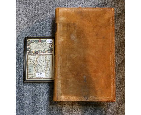
Lot 423
William Augustus Russel, A new and authentic history of England, from the most remote period of genuine historical evidence to the present important crisis... (London, J. Cooke, Shakespeare's -head, No. 17. Pater-Noster Row, [1777-81?]), fo., 100 engravings including frontispiece and protrais of the Kings and Queens of England, book plate for 'J. Howse 1829', bound in calf; together with a framed and coloured map engraving depicting the road from London to Barrick (2)

Lot 258
MAP OF GLASGOW,framedCondition report: Dated late 19th century (pictured), depicting map od Glasgow in 1650.Condition is good to fair: two stripes of discouration in the centre, spot of dirt trapped under glass. Frame slightly aged and worn. Map appears to be attached to a board. Additional images available.
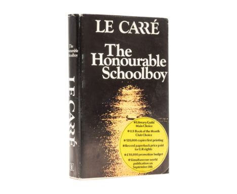
Lot 176
Le Carré (John) The Honourable Schoolboy, uncorrected proof copy, bookplate double-signed by the author on title, map endpapers laid down as issued, original stiff wrappers, light creasing to upper cover, proof dust-jacket, minor chipping, light creasing and rubbing to spine tips and corners, an excellent example overall, 8vo, 1977.⁂ The scarce dust-jacket differing from that on the first edition in a few respects being slightly shorter, with a promotional sticker to upper panel, larger spacing to the text on the lower flap and with a misspelling of the photographer's surname.
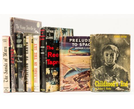
Lot 60
Clarke (Arthur C.) Childhood's End, jacket with chipping to head and foot, rubbing and creasing to extremities, 1954; The Reefs of Taprobane, signed by the author on half-title, ink stamp to half-title, map endpapers, jacket price inked out, jacket spine ends and corners chipped, closed tear and some creasing to head, extremities rubbed, 1957; The Sands of Mars, card signed by the author loosely inserted, map frontispiece, toning to text margins, ink ownership inscription, jacket with light toning to spine, spine ends and corners a little chipped, light creasing to foot, 1951, first or first English editions, original boards, dust-jackets; and 5 others by the same, 8vo (8)
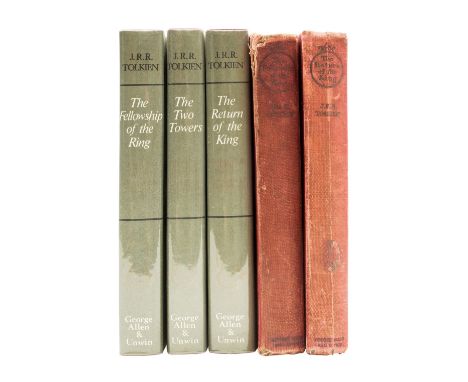
Lot 271
Tolkien (J.R.R.) The Return of the King, first edition, folding map, small library stamp to title and front endpaper, original cloth, slightly soiled, spine toned and a little worn, 1955; The Fellowship of the Ring, fifth impression, upper hinge weak, original cloth, slightly soiled, spine head and extremities rubbed, 1956; The Lord of the Rings, 3 vol., 3 folding maps, bookplates to front pastedowns, original cloth, dust-jackets, 1971, 8vo (5) ⁂ Return of the King with signature mark '4' and text block sagging.


Lot 534
TWO SIGNED LETTERS BY FRANCIS CHICHESTER one describing his plans for a trip leaving Plymouth beating his record to Ambrose Light, New York in forty and a half days, dated 14th March 1962; the other dated 27th March 1962 on Francis Chichester Ltd letter head, Navigation Specialist, Map Makers and Publishers (2)


Lot 404
Lloyd (William Watkiss)'The History of Sicily to the Athenian War...' with folding map. 8vo. Blue cloth. 1st Ed. John Murray, London 1872 plus 'Explanation of the Groups in the Western Pediment of the Parthenon 1854 with folding diagram. Full calf plus five assorted pamphlet form publications. All much worn (7) Provenance: From the Estate of Patrick Dockar-Drysdale

Lot 466
Ruskin (John) (1819-1900) English Writer and Polymath 'Notes by Mr Ruskin on His Collection of Drawings by the Late J.M.W. Turner R.A.'. Fine Art Society, London 1678. With 35 plates and map. Small Fo. Untrimmed paper. Some warping and staining. Original boards scuffed. With dedication by the Revd. Stopford Brooke from the Fine Art Society Feb, 1879 Provenance: From the Estate of Patrick Dockar-Drysdale


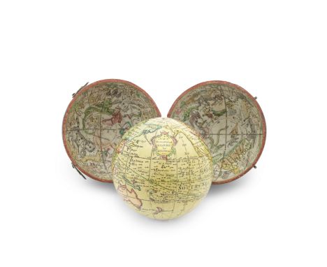
Lot 3
A John Newton 2 ½-inch Pocket Globe in Case, English, circa 1790,the cartouche printed A NEW Terrestrial GLOBE by J. Newton 1783, the sphere applied with gores hand coloured in red, yellow, and green, showing the trade winds and monsoons indicated by arrows, the Dampier Strait labelled, California shown as a peninsula, north-eastern Canada labelled Unknown Parts, the tracks of Anson's voyage and Cook are shown, Australia (labelled New Holland) and New Zealand drawn according to Cook's discoveries, in fish-skin covered case with two hooks and eyes, with map of the heavens applied to inner two hemispheres, 3in (7.5cm) diameter cased Footnotes:John Newton (1759-1844) founded the Newton family firm in the 1780s, an enterprise which flourished into the 19th century with support from various family members. The workshop primarily made pocket and table globes, before expanding to include mechanical planetaria. Newton globes were advertised in ten available sizes, ranging from just 1 inch up to 25 inches in diameter.For further information on this lot please visit Bonhams.com
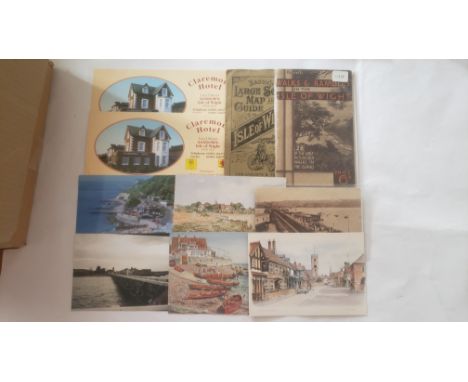
Lot 594
ISLE OF WIGHT, selection, inc. softback editions, Englands Eden, The Isle of Wight Book of Days, Yesterdays Papers (4), vol. 2-5 etc; postcards (15*), Shanklin, Seaview, Freshwater, Yarmouth, Cowes, (a few pu); Hardings guide map to the Isle of Wight, Bacons large scale map, photographs etc., G to VG, 30*

Lot 103
WW2 Polish Fighter Pilots printed Information Sheets Relating to WW2. A Obituaries of Kazimiers Paddy Szrajer events over a Captured V 2 Bomb. Prints of Details of Polish Pilots Killed in Dungeness Area including a map of crashes and Printed Newspaper Clipping. Includes is 3 printed photos of Flight Sergeant DJ Hulbert From a Leading Battle Of Britain Expert Personal Collection. Good condition. All autographs come with a Certificate of Authenticity. We combine postage on multiple winning lots and can ship worldwide. UK postage from £4.99, EU from £7.99, Rest of World from £9.99

Lot 153
10 4 38 Bad Godesburg Am 10 April Dein Fuheer Den Ja Special Postmark. 13 Marz 1938. Ein Volk Ein Reich Ein Führer. An illustration of a golden German map with a photograph of Hitler s face in profile pasted onto it. Caption reads: 13 Marz 1938. Ein Volk Ein Reich Ein Führer. Good condition. All autographs come with a Certificate of Authenticity. We combine postage on multiple winning lots and can ship worldwide. UK postage from £4.99, EU from £7.99, Rest of World from £9.99

Lot 700
Germany, Weimar Republic, Atlantic “Meteor” Expedition Medal 1925-27, 1st class, silver, the edge inscribed, ‘Bayer Hauptmunzamt, Feinsilber’, with silver-gilt oak leaves suspension, in its original gilt inscribed, red leather fitted case of issue, nearly extremely fine, rare £600-£800 --- Issued by the Research Aid Society of German Science, and designed by the Bavarian Mint, 23 1st Class Medals were issued with gilt oak leaves to naval officers and civilian scientists, and 188 2nd Class Medals were issued with silver oak leaves to crewmen. In the aftermath of Germany’s defeat in the Great War, in a period of political and economic chaos, emerged one of the most important oceanographic expeditions of the 20th century, an expedition made possible by the establishment of the German Scientific Research Aid Council in 1920, a body charged with salvaging the pride of the country’s scientific research establishment. And it was in the spirit of that stated aim, in 1924, that Vienna-born oceanographer, Professor Alfred Merz of Berlin University, asserted that the ocean offered an open door of opportunity for exploration - that a well-planned voyage would invite solutions to many important questions of the deep - a view shared by the Council’s president, who quickly gathered the required support. As a result, the Meteor was fitted out for just such an expedition, a brigatine rig being put in place to reduce her reliance on fuel. Commanded by Kapitän zur See F. Spiess, with Merz heading the scientific agenda, her specially trained crew numbered 123 men, including 10 officers, 29 Petty Officers, 78 ratings and 6 civilians - given that the Medal was awarded to a total of 211 recipients, it must be assumed that some of these men were exchanged during the course of her voyage, and that other individuals indirectly connected with the expedition were also eligible for the award. In any event, the Meteor departed in April 1925 and conducted a shake-down cruise to the Canary Islands to ensure readiness for the voyage. Afterwards, a strenuous around the clock programme of scientific measurements was undertaken: water temperatures, depths, atmospheric observations and collecting water samples and marine life. In the end, the Meteor criss-crossed the Atlantic on no less than 14 occasions, from the northern tropics to Antarctica, and, using the ship's early sonar, profiles of the ocean floor were created between 20º N and 55º S. In addition, the expedition established 310 hydrographic stations and made 67,400 depth soundings to map the topography of the ocean floor, and released over 800 observation balloons, while an analysis of 9,400 measurements of temperature, salinity and chemical content at varying depths established the pattern of ocean water circulation, nutrient dispersal and plankton growth - a notable discovery during this survey was the extension of the Mid-Atlantic Ridge around the Cape of Good Hope towards the Indian Ocean and the Meteor was also the first to record an entire ocean's currents and make extensive studies of surface evaporation. By the time of her return to Germany in May 1927, Meteor had spent 512 days at sea and sailed over 67,500 nautical miles, thereby achieving a victory in peace for science and for Germany. The above information has been based on research undertaken by Glenn M. Stein, F.R.G.S.
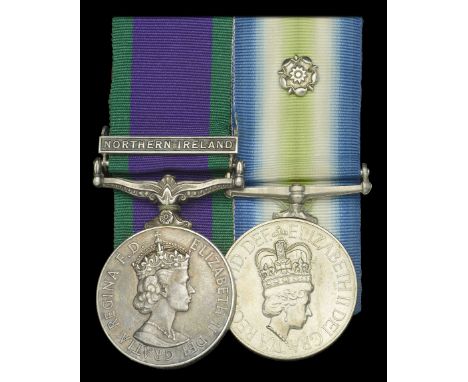
Lot 428
Pair: Private R. C. Hunter, Royal Army Ordnance Corps, attached to 2 Para in the Falklands War General Service 1962-2007, 1 clasp, Northern Ireland (24204706 Pte. R. C. Hunter RAOC); South Atlantic 1982, with rosette (24204700 Pte R C Hunter RAOC) note error in regimental number, mounted court-style but pin removed, very fine (2) £1,000-£1,400 --- R. C. Hunter is believed to have been attached to the 2nd Battalion, Parachute Regiment during the Falklands War. Sold with several photographs, including one with Major-General Jeremy Moore and another of captured arms; ‘Sympathy and Congratulatory Signal from Chief-General-Staff’ addressed to 2 Para, dated June 1982; special edition of the Aldershot News upon the return of the Paras, July 1982; Billingham (Stockton-on-Tees) Parish magazine announcing ‘Congratulations to Mr & Mrs Hunter of 9 Finchale Avenue, on the safe return of their son, Robert from the Falklands Islands Task Force. They also have two more sons in the Army.’; and a Ministry of Defence ‘Operation Corporate Manoeuvre Map, 21 May - 14 June 1982’, showing movements of major units of 3 Cdo Bde and 5 Inf Bde on East Falkland.
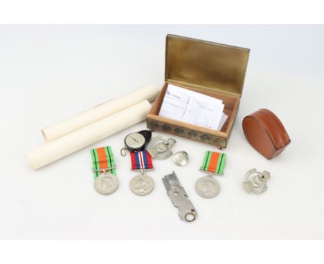
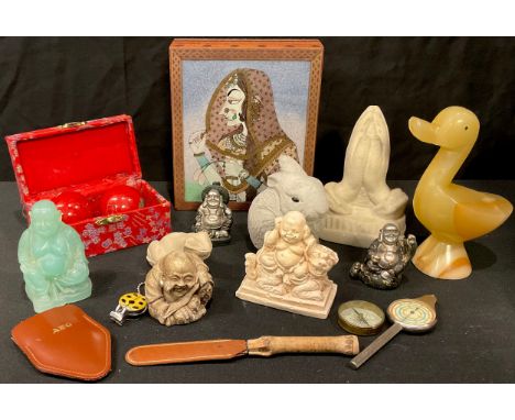
Lot 40
A Rare Original Second World War Period ' Handy MP Knife', folding knife with magnifying glass and wire stripper, making use of a disposable razor as the blade.possibly for use by downed RAF pilots / POW to aid espace, 6cm when folded; together with two Defense Medals and War medal, Civil Defence Comitee Warden certificates, ARP button, map measuring tool and compass, plus a pair of 1930s RAC lapel badges (a lot)


-
109182 item(s)/page