

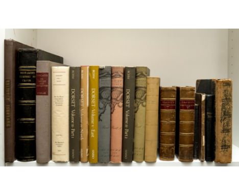
NO RESERVE Nottingham.- White (William) History, Gazetteer, and Directory of Nottinghamshire, title and several leaves laid down on tissue, bound without map, scattered spotting, advertisements at end, ex-library with ink-stamp, modern cloth, Sheffield, 1844 § White (Francis) History, Directory and Gazetteer of ... Nottingham, title and several leaves strengthened with tissue, occasional light spotting and finger-soiling, bound without map, ex-library, modern cloth, Sheffield, 1853 § Orange (James) The Nottingham Annual Register ... and a New and Corrected Directory for 1840, title and several leaves laid down on tissue, several names scored out by hand, advertisements at end, ex-library with usual ink-stamps, modern cloth, 1840 § Glover (Stephen) The History and Directory of the ... Town of Nottingham, title laid down on tissue, ex-library, modern cloth, Nottingham, 1844; and other Nottingham directories, v.s. (13)
We found 109182 price guide item(s) matching your search
There are 109182 lots that match your search criteria. Subscribe now to get instant access to the full price guide service.
Click here to subscribe- List
- Grid
-
109182 item(s)/page

NO RESERVE Nottingham.- Salmon (Edward) Plan of the Town of Nottingham and its Environs, large map in six sections, lithographs on wove paper mounted onto linen, each sheet 680 x 860 mm (26 3/4 x 33 3/4 in), several sections with large marginal repaired tears and areas of loss, otherwise handling creases, some nicks to extremities, all sheets with strip affixed with ring binding holes to one edge, minor surface dirt and browning, unframed, James Wyld, [circa 1870]⁂ Scarce at auction.

NO RESERVE Nottingham.- Speed (John) The Countie of Nottingham described, The Shire Townes Situation and the Earls thereof Observed, two variant states of Speed's county map of Nottingham, including one Sudbury and Humble without text verso, engraving, both on laid papers and mounted onto linen support, each sheet approx. 390 x 530 mm (15 1/4 x 20 3/4 in), purple ink stamps of 'Nottingham Free Public Libraries' to each, old folds and handling creases, several repairs to nicks and losses, some repaired splitting, unframed, Sudbury and Humble, and Bassett and Chiswell, respectively, [circa 1610-1676]; together with a good group of 18 other maps of Nottingham, all from the 'Nottingham Free Public Library', including Frederic Sanderson's 'Poor Law Union and Parish Map of the County of Nottingham', numerous unpublished proposal maps and plans, a Morden county map, and others, various sizes, all unframed, 17th to 20th century (20)
Yorkshire.- Miller (Edward) The History and Antiquities of Doncaster, folding engraved map frontispiece, list of subscribers, 11 engraved plates, illustrations, frontispiece with 2 tears with old tape repairs, with very small portion of marginal loss, another plate with short marginal tear, scattered spotting, mainly to plates, the odd patch of light soiling, water-staining to a few plates, modern cloth, red morocco labels to upper cover and spine, faint spotting to spine, uncut, Doncaster, 1804; and others, British topography, including an album of early 20th century photographs of Bedfordshire, v.s. (18)

America.- Agriculture.- Cultura americana que conte'm huma relaçao do terreno, clima, produçao, e agricultura das Colonias Britanicas no Norte da America, e nas Indias Occidentais, 2 vol. in 1, engraved folding frontispiece map, titles with woodcut royal arms, errata at end of vol.1 and to final verso, index ff. for both vol. at end of vol.2, vol.1 sig. SS duplicated (vol. complete), occasional spotting, lightly browned, contemporary mottled calf, richly gilt spine in compartments and with black morocco label, spine repaired and a little chipped, little worming to lower cover, corners worn, rubbed, [Borba de Moraes (1983) II, 674; Bosch 258; Innocêncio IV, 321 & VIII, 110; Período Colonial 285; Sacramento Blake I, 129 & IV, 417; Sabin 62954 & 106062], a good copy, 8vo, Lisbon, Antonio Rodrigues Galhardo, 1799.⁂ A partial translation of American husbandry. Containing an account of the soil, climate, production and agriculture, of the British colonies in North-America and the West-Indies, 1775. It is variously attributed to the English botanist Dr. John Mitchell, who settled in Virginia; or to the English agriculturalist Arthur Young.
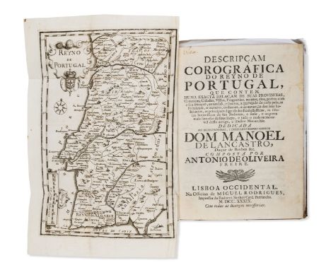
Portugal.- Oliveira Freire (Antonio de) Descripçam corografica do Reyno de Portugal, first edition, engraved folding frontispiece map (not called for), woodcut head- and tail-pieces and decorative initials, some staining / water-staining, occasional spotting, lightly browned, contemporary mottled calf, richly gilt spine in compartments and with morocco label, spine ends and corners worn, upper cover with worm trace and scuffmark, rubbed, [Innocêncio I, 214 & VII, 433], Lisbon, Miguel Rodriguez, 1739; and 3 others, 18th century Portugal, 1 an odd vol., v.s. (4)
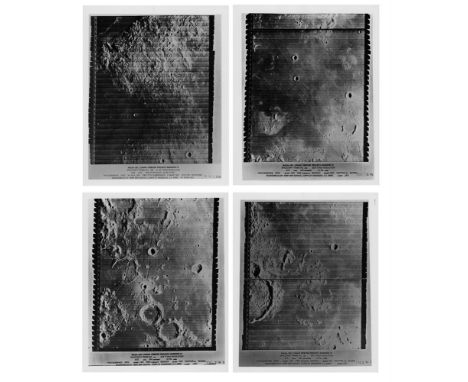
Four superb high resolution views of the lunar surface, high resolution frames IV-109-H2, IV-132-H2, IV-132-H3, IV-137-H2, Lunar Orbiter 4, May 1967 Vintage gelatin silver prints on fibre-based paper, 25.3 x 20.3 cm (10 x 8 in), with detailed NASA Langley Research Center / US Army Map Service photo informations in bottom margins, (4)Footnotes: The objective of Lunar Orbiter IV and V was to provide an expanded photographic survey of the lunar surface, offering far higher resolution imagery than was available from ground based telescopes. The two last orbiters brought the cumulative photographic coverage by the five Lunar Orbiter craft to 99% of the Moon's surface and amazing detailed views of the Moon's surface.

Four great medium resolution views of the lunar surface, medium resolution frames V-54-M, V-97-M, V-102-M, V-125-M, Lunar Orbiter 5, August 1967 Vintage gelatin silver prints on fibre-based paper, 25.3 x 20.3 cm (10 x 8 in), with detailed NASA Langley Research Center / US Army Map Service photo informations in bottom margins, (4)Footnotes: The objective of Lunar Orbiter IV and V was to provide an expanded photographic survey of the lunar surface, offering far higher resolution imagery than was available from ground based telescopes. The two last orbiters brought the cumulative photographic coverage by the five Lunar Orbiter craft to 99% of the Moon's surface and amazing detailed views of the Moon's surface.
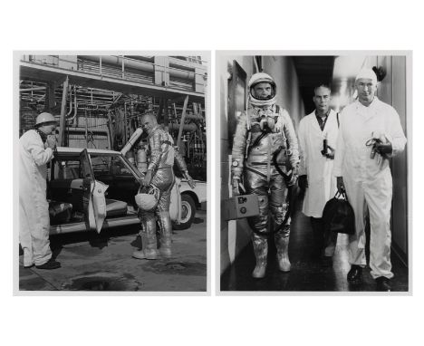
Four views of John Glenn during various phases of the preparation for the first manned orbital American mission Mercury Atlas 6, February 1962.Vintage gelatin silver prints on fibre-based paper, 20.4 x 20.3 cm (10 x 8 in), with NASA captions on versos of the first three, (NASA, Cape Canaveral), (4).Footnotes: Glenn enters station wagon at during simulated activities at Cape Canaveral (first photo), Glenn, Dr. Douglas and suit technician Joe Schmitt at the Aero Med facilities of the famous Hangar S at Cape Canaveral (second photo), Glenn studies recovery map with Astronaut Deke Slayton looking on (third photo), Glenn in front of Mercury network tracking antenna (fourth photo).
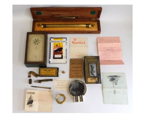
A collection of items owned by Sir. Edgar Britten who was a Cunard Line captain & the first captain of the ocean liner RMS Queen Mary in 1936 to include a Queen Mary compass box, a brass map reader, inscribed Commander E. T. Britten KB RD RNR, an art deco RMS Queen Mary ashtray, United States Lines Europe blotter presented to E. T. Britten & various Cunard ephemera with other objects

A silk lined box, owned by Queen Mary, wife of King George VI, bearing her monogram in silver, containing an ivory handled & white metal map wheel & a private note from Queen Mary, gifted personally to King George VI Royal chauffeur, William George Figg. Ivory weight is less than 10% of total & an exemption certificate has been obtained: Ref. no. ND7CBNR3


Two retro 1960s General Post Office GPO-produced educational / advertisement map posters, being a 1968 'Submarine Telephone Cables and Microwave Radio Systems between the United Kingdom and Europe' to measure 54cm x 42cm, and 1969 Tele Ed 2 'Post Office Overseas Telecommunications Services' map of Europe designed and drawn by Brian Craker, to measure 100cm x 72cm. (2)


VARIOUS PRODUCTIONS - Doug Beswick-Autographed Medium Stop-Motion Surface Gauge - A medium-size stop-motion surface gauge autographed by Doug Beswick. Beswick worked as a stop-motion artist and animator on several of history's most popular films, including Star Wars: The Empire Strikes Back, The Terminator, and Aliens.Beswick used this metal gauge, essential in stop-motion animation, to map scale and distance between puppets and models in animation sequences. It consists of two adjustable rods mounted to an elevated base, which in turn is screwed into a large base. The higher base is signed in silver-color marker by Beswick and exhibits some scratching; the metal rods exhibit some discoloration. Dimensions: 9.5" x 5" x 3.5" (24.25 cm x 12.75 cm x 9 cm)Estimate: $1,000 - 2,000Bidding for this lot will end on Friday, June 30th. The auction will begin at 8:00AM PDT and lots are sold sequentially via live auctioneer; tune in to the live streaming broadcast on auction day to follow the pace. Note other lots in the auction may close on Wednesday, June 28th or Thursday, June 29th.

TALES FROM THE CRYPT PRESENTS: BORDELLO OF BLOOD (1996) - Vincent Prather's (Phil Fondacaro) Framed Treasure Map - Vincent Prather's (Phil Fondacaro) framed treasure map from Gilbert Adler's horror comedy Tales from the Crypt Presents: Bordello of Blood. Prather followed his treasure map to a cave containing Lilith (Angie Everhart), the mother of all vampires. This color-printed map of the Tierra del Fuego archipelago features a trail marked with a red "X." It comes mounted behind glass in a custom wooden frame painted gold-color and black and affixed with a metal hanging wire on the reverse. The map is intentionally distressed by production to appear burned and torn from age and use. Dimensions: 16" x 15" x 1" (40.75 cm x 38.25 cm x 2.5 cm)Estimate: $600 - 1,200Bidding for this lot will end on Friday, June 30th. The auction will begin at 8:00AM PDT and lots are sold sequentially via live auctioneer; tune in to the live streaming broadcast on auction day to follow the pace. Note other lots in the auction may close on Wednesday, June 28th or Thursday, June 29th.
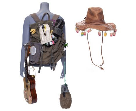
TANK GIRL (1995) - Tank Girl's (Lori Petty) Backpack and Hat - Tank Girl's (Lori Petty) backpack and hat from Rachel Talalay's sci-fi film Tank Girl. Tank Girl carried her backpack scavenging and wore her hat as she dressed for the sex club.This lot consists of a canvas and faux leather backpack, hat, and accessories. The backpack's attached bag has a reflective disk, charms, keychains, silver-color foil around one strap, a canteen, spoon, broken toothbrush, map, feather, and gold-color lantern. Included is a ukulele. The hat features dangling cork stoppers. The lot exhibits cracked, peeling leatherette, discoloration, scratches, and production-added distressing to appear aged and dirty. Dimensions: (backpack) 20" x 17" x 12" (51 cm x 43.25 cm x 30.5 cm)Estimate: $800 - 1,600Bidding for this lot will end on Friday, June 30th. The auction will begin at 8:00AM PDT and lots are sold sequentially via live auctioneer; tune in to the live streaming broadcast on auction day to follow the pace. Note other lots in the auction may close on Wednesday, June 28th or Thursday, June 29th.

JURASSIC PARK (1993) - Park Visitor Brochure - A park visitor brochure from Steven Spielberg's Academy Award®-winning sci-fi action-adventure Jurassic Park. The park's brochures appeared at various locations, including the Visitor Center and within the Ford Explorer tour vehicles.This double-sided, glossy paper brochure features a printed map of Jurassic Park on one side pinpointing sites on the island, including the Visitor Center, helipad, dinosaur enclosures, and fences. Its reverse features a printed drawing of the park gates with general information, a section in Japanese, a camera film advertisement, and a mountain terrain photograph that forms the cover. The brochure exhibits creasing and edge wear from folding. Dimensions: (folded) 8.25" x 4" (21 cm x 9.5 cm)Estimate: $3,000 - 6,000Bidding for this lot will end on Wednesday, June 28th. The auction will begin at 8:00AM PDT and lots are sold sequentially via live auctioneer; tune in to the live streaming broadcast on auction day to follow the pace. Note other lots in the auction may close on Thursday, June 29th or Friday, June 30th.
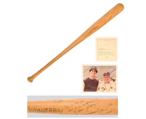
THE NATURAL (1984) - Robert Redford-Autographed Roy Hobbs' Rehearsal "Wonderboy" Bat - A Robert Redford-autographed Roy Hobbs' rehearsal "Wonderboy" bat from Barry Levinson's sports drama The Natural. Baseball star Hobbs' signature bat Wonderboy was carved from the wood of a tree that was struck by lightning at the same time his father (Robert Rich III) suffered a heart attack. While the standard Wonderboy bats featured in the film were wood-burned, the text and symbol on this example were carved in and then outlined with marker; the bat was used during production for rehearsals, and may have been one of the early prototypes for the wood-burned bats seen on screen. When filming wrapped on the movie, this bat was signed and inscribed by Redford and gifted to Chris Pollack - the son of the film's costume designer Bernie Pollack and nephew of the producer Sydney Pollack. The inscription reads: "Dear Chris, This is my bat and it is impervious to your pitching - Robert Redford (Roy Hobbs)." Chris was an aspiring baseball player himself and previously spent time on set during filming, where he got to know Redford and other cast members.A few years later, when Chris Pollack signed with the Montreal Expos and entered professional baseball, Redford sent him a letter of congratulations stating "I know it was the bat," a joke that this Wonderboy prop bat was the reason for Pollack's success.Designed by property master Barry Bedig from period-specific Louisville Sluggers, this light brown oak bat features "Wonderboy" and a lightning-shaped "W" symbol carved into it. Also included is a color photograph of Chris Pollack and Robert Redford on set, which is signed and inscribed "Can you spot the Natural? Fondly, Robert Redford"; the congratulations letter Redford sent to Pollack in 1987; two strips of negatives for photos taken on set while Pollack visited enclosed in an envelope printed with a "The Natural" logo in the upper left corner; an invitation to the film's premiere enclosed in a Tristar envelope with a matching production logo; an RSVP card to the invitation; and a site map for the studio premiere. The Natural received four Academy Award® nominations, including Best Actress in a Supporting Role for Glenn Close, Cinematography, Art Direction, and Music. It is frequently cited as one of the best baseball movies ever made. The bat exhibits light scratches from use and fading from its age. Dimensions: 32.5" x 2.5" x 2.5" (82.75 cm x 6.5 cm x 6.5 cm)Estimate: $15,000 - 30,000Bidding for this lot will end on Wednesday, June 28th. The auction will begin at 8:00AM PDT and lots are sold sequentially via live auctioneer; tune in to the live streaming broadcast on auction day to follow the pace. Note other lots in the auction may close on Thursday, June 29th or Friday, June 30th.

NATIONAL TREASURE: BOOK OF SECRETS (2007) - Book of Secrets' Papers and Articles - Book of Secrets' papers and articles from Jon Turteltaub's action-adventure film National Treasure: Book of Secrets. Ben Gates (Nicholas Cage) located the President's Book of Secrets at the Library of Congress filled with articles and entries from previous presidents. This lot consists of various page inserts for the President's Book: four torn newspaper articles; nine black-and-white and color images of the moon landing and President Kennedy with handwritten notes; three blue FBI Wanted flyers; 25 paper and vellum White House letterheads; one map; and 10 top secret documents. This lot exhibits production made distressing on the pages throughout and fold creases. Dimensions: (extended) 18" x 10.5" (45.75 cm x 26.75 cm)Estimate: $1,500 - 3,000Bidding for this lot will end on Friday, June 30th. The auction will begin at 8:00AM PDT and lots are sold sequentially via live auctioneer; tune in to the live streaming broadcast on auction day to follow the pace. Note other lots in the auction may close on Wednesday, June 28th or Thursday, June 29th.
A Small Quantity of Second World War Ephemera, including a framed Secret Composite Sheet Map of Germany showing the area where the Germans surrendered to Montgomery, various Second World War Civil Defence pamphlets, three publications The Fifth British Division 1939-1945, Report by the Supreme Allied Commander Mediterranean to the Combined Chiefs of Staff on The Italian Campaign 8th January 1944 to 10th May 1944, and Bomber Command, a quantity of newspapers, framed and unframed etchings
A Quantity of Militaria, including a modern Mess dress uniform to a Captain, slip-on shoulder rank straps, a Territorial flag, lanyards, a stable belt, an H.M. Forces Saving Map of the British Army, prints, two large portrait photographs of Elizabeth II and the Duke of Edinburgh with facsimile signatures, button plates, French and US badges etc.

A First World War RFC Navigation Map Board, in boxwood, the arched pediment set with a compass, with brass paper rollers to each side and buckled leather wriststrap to the back; an Elliott Speed Indicator Cockpit Instrument, numbered 27348; four Pieces of RFC Trench Art, comprising a copper ashtray, a brass cigarette lighter, trivet and a brass and copper mug and cover; also, an RFC canteen tea cup and saucer, two RFC embroidered cloths, a 1918 Victory flag printed with a Union Jack and RAF badge, a silver plated cake basket, later set with a German First World War pilot's badge; a Japanese Ice Carving Knife, the 10cm bevelled blade with squared off chisel head, the hardwood grip and scabbard with bone mount. (Belonged to vendor's grandfather in the 1920's who was Captain of SS Millpool which sank with all hands on 3rd October 1934 during a hurricane in the Atlantic).(11)

A mixed lot to include various tablecloths, some boxed, Lady Clare placemats and coasters, and other table accessories including LSA drinking glasses, Delux lever action corkscrew, and other items, along with a framed and glazed map of Cumberland, and a print of Melton Mowbray market place Location:

After Michael Drayton (1563-1631)map of Glocestershyre (sic), from the poetic travelogue 'Poly-Olbion', 25cm x 33cm and a map of Glocestershire (sic) after Robert Morden, 34cm x 42cm (2)Provenance:The collection of Paul Whitfield (1942–2018)The Drayton map has some discolouring and wear around the fold. The Morden map is creased and has some foxing.
![Turkish Empire. Ortelius (Abraham), Turcici Imperii Descriptio, [1579], engraved map framed and glazed](https://cdn.globalauctionplatform.com/ee333b27-c84c-4bb1-b04e-b00300d1600d/6e9c4b0d-e2a6-4b4c-8199-b02d009f6137/468x382.jpg)


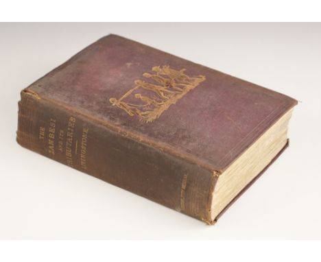
Livingstone (David & Charles), NARRATIVE OF AN EXPEDITION TO THE ZAMBESI AND ITS TRIBUTARIES; AND OF THE DISCOVERY OF THE LAKES SHIRWA AND NYASSA 1858-1864, first edition, red cloth, gilt embossed illustration to boards, pasted and tipped in advertisement pages, foldout engraved frontispiece, engraved plates and illustrations, foldout map, John Murray, London 1865 (at fault)

DECORATIVE BINDINGS: A miscellany of works on religion, to include Geikie (Cunningham), THE LIFE AND WORDS OF CHRIST, two vols, full tree leather, gilt embossed decoration to boards and spine, marbled block, marbled endpapers, fold out Palestine map frontispiece to volume one, Cassel & Co Ltd, London 1885; Gardner (James), THE FAITHS OF THE WORLD, A DICTIONARY OF ALL REGIONS AND RELIGIOUS SECTS, two vols, ¾ leather, marbled block, marbled endpapers, engraved frontispiece, illustrated title page, A Fullarton & Co, London; Benson (C), ON SCRIPTURE DIFFICULTIES, second edition, ¾ leather, marbled boards, Baldwin, Craddock and Joy, London 1825, Benson (C), ON EVIDENCES OF CHRISTIANITY ETC, Baldwin, Craddock and Joy, London 1825; Burkitt (W), EXPOSITORY NOTES, WITH PRACTICAL OBSERVATIONS UPON TH ENEW TESTAMENT OF OUR LORD AND SAVIOUR JESUS CHRIST, printed for John Bumpus, London 1825, etc (Qty) (at fault)

A George III Laurie & Whittle’s ‘Geographical Pastime for England and Wales’ game, comprising a hand coloured map on linen in 16 sections, with descriptions of some of the cities and towns and rules of the game on either side of the map, in original blue cardboard sleeve with applied label, published by Laurie and Whittle, London, 1794, the map 55cm x 68.5 cm (opened) (at fault)


George III oval silk embroidered map of the United Kingdom, dated 1796 and named Mary R Mortimore, Bradninch, in glazed mahogany frame, 54 x 47cmOverall condition is quite good, a few small tears to border (see images) colours are muted and some time staining to the linen ground, various splits to the original frame

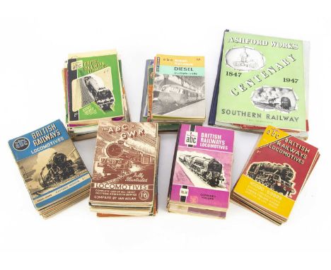
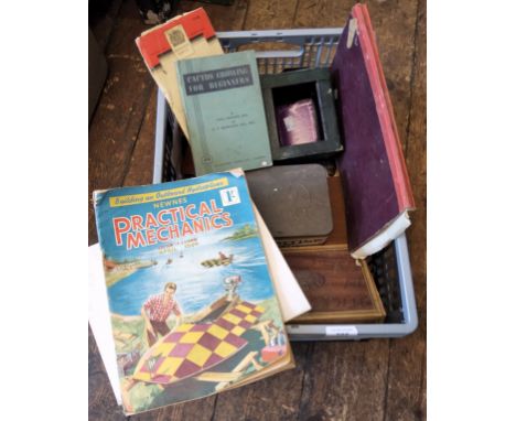
ABC Guides and Other Railway Related Volumes (70+) a large collection of Ian Allan ABC guides some with annotations/markings, British Railways Locomotives (22), ABC of LMS (2) 1943/45, ABC of LNER (4), 1943, 1946 92), 1947, ABC of Southern (3), 1943, 1945 (2), Locoshed Book (8) and two hard back combined volumes, British Railway Coaches, British Electric Trains, London Transport Railways, British Express Trains, Southern Locomotives and Electrics, BR Diesels, BR Diesel Multiple Units, Southern and LMS, ABC of GWR (3) 1943, 1945 (2) with differing covers, Famous Trains No 7, Romney Hythe & Dynchurch (4), Locomotives and Engineers of the SR 1946, Sectional Map of the BR 1948, six later/reprinted volumes, Christian & Sykes BR locomotive Reference 1951, locomotives of the LMS 1947 by LM&SR, Travelling on the Southern Railway 1946 (2), Ashford Works 1947 Centenary SR, Festival of Trains 1951 (BR), Good Firemanship 1956 (BTC) and 1951 LT/BR Welcome to London Festival of Britain pocket/guide, F-G, (70+)

Two Postwar Exeter Tourism Posters, two posters, one depicting a map of the county of Devon, Exeter The Heart of Devon The Finest Centre For Touring Devon, designed and printed by Southwoods Exeter (one small nick out of bottom edge), the other with text and illustrations of the Cathedral and Guildhall City and County of the City of Exeter Places of Interest, by Wheaton Exeter, each 50cm wide x 75cm high, both G, (2)

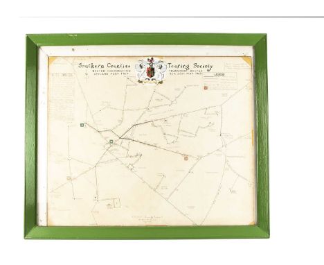
Southern Counties Touring Society Souvenir Excursion Maps and Tickets, two maps framed and glazed, hand drawn map of Exeter Corporation Transport Routes Leyland PD2/1 Trip Sunday 30th May 1965, depicting Horse Tramways, Electric Tramways and Motor Omnibus routes, scale 6" to 1 mile, 60cm wide x 50cm high, a printed copy of South London Tram Tour 25th June 1950 in car no 1877, originally drawn by F Merton Atkins July 1950, 55cm wide x 37cm high and a collection of related tickets, G, (Qty)

Edwardian and Later London Tram Bus and L&SWR Guides and Publications, 1909 edition published 1910 by Armitage and Ibbetson, Official Tramways Guide issued by London County Council, includes period advertising and guide to London and tram routes, (spine poor), The Panoramic Guide of the London & South Western Railway 1909, contains period adverts and illustrations (one page cut spine poor), London Guide No 3 issued by London Underground published by Odhams 1924, a guide to London includes a pocket map of London's transport network (spine poor), Round & About London by Tram North and South of the Thames (two volumes), by Charles G Harper, both include many period adverts 1920s/30s, both G, pocket maps,1947 Trolleybus & Tram map of routes London Transport, hand written For the Chairman's Use with inked route on map, Greenline 1948 coach map also hand written for the Chairman's Use, 1926 London & London's Country published by London Underground list of excursions, by train and bus and ABC Guides by Ian Allan, London Transport Buses and Coaches, 1952 (pages cut many notes) and the eighth edition (many notes), London's Transport Services 1944, No 2 Trams and Trolleybuses 1948, Buses Coaches & Trolleybuses ninth edition many listings underlined and Buses & Coaches 7th edition also with many listings underlined, P-VG, (14)

-
109182 item(s)/page