We found 109198 price guide item(s) matching your search
There are 109198 lots that match your search criteria. Subscribe now to get instant access to the full price guide service.
Click here to subscribe- List
- Grid
-
109198 item(s)/page


Lot 196
Four map related books 'Christopher Saxton's 16th Century Maps' by Chatsworth Library, 'British County Maps Reference & Price Guide' by Yasha Beresiner, Antique Collector's Club, 'Antique Map Price Guide No. 2', 2017 edition and 'Antique Maps of North Wales' by John Booth, second edition with dust cover


Lot 321
Large shoe box lot of assorted tea, cigarette cards and postcards, including quantity of Ogden Guinea Golds, 1914 Ogden's Owner's Racing Colours and Jockeys, Ogden Optical Illusion, Prominent Racehorses and Leader's of Men, Kensitas, Major Drapkin & Co, King Egbert Rowntree, Mitchell, A Road Map of Scotland.

Lot 321
J Bye, "Commencement of the Roads to the Lakes of Lancaster, Westmoreland & Cumberland, as far as Hinckley & Leicester", hand coloured road map, 30.5cm x 25.5cm visible size, The Road from London to Derby, hand coloured road map, 16 x 21cm visible size, The Road from Hereford to Leicester, hand coloured road map, 16 x 21.5cm visible size, and Southam-Coventry-Nuneaton-Ashby de la Zouch-Derby road map, hand coloured, 18.5 x 12.8cm visible size. (4)


Lot 85
MILITARY INTEREST a WWII canvas map holder, a WWI oval wall mirror with a photographic print of a soldier, an army metal helmet, The Commandants Prize For The Best Quick March (The Collins Cup) awarded to S/B T. L. Crichton A.R.C.M. of the Argyle & Sutherland Highlanders, 1965 and a wooden model of a British WWI tank


Lot 503
Six Facimile maps of London - St Marylebone/St Pancras/Paddington in 1834, two sheets, engraver BR Davies, Publisher The Topographical Society in 1962- George IVs Map of British Metropolis in 1827, six pages, Printer Headley Bros, Publisher Harry Margary - Langley & Belchers New Map of London, in 1812, publisher The Topographical Society in 1971 - Hollars Exact Surveigh of the City of London in 1687, publisher, The Topographical Society - Atlas of London - Relief and Drainage/sand and gravel sources/Hydrography 1971 - publisher European Printing Corp for Pergamon Press from Ordanance Survey maps, three pages - Facsimile of the Ordanance Surveyors Drawings of the London Area 1799-1808


Lot 315
The history of the decline and fall of the Roman Empire. New edition by Edward Gibbon esq. Twelve volumes, folding engraved map by Thomas Kitchin Snr published by Vernor, Hood & Shape, included in Volume 1 printed for and sold by J Robertson No15 Nicolson Street and No4 Horse Wynd Edinburgh 1806

Lot 622
STAMPS : TURKEY : ALEXANDRETTA & HATAY, a superb collection starting with the overprinted 1938 Alexandretta set used inc Air stamps, 1938 used set of five with black borders opt & postage due set used. Then Hatay issues with 1939 Turkey issue optd used, 1936 Map & Flag used set of 13 etc with mint perf & overprint varieties. 1939 annexation of Hatay to Turkey overprinted mint stamps with varieties etc. Fine, well presented collection!


Lot 201
Marked to top GRAY'S NEW MAP OF THE WORLD IN HEMISPHERES.Original, displayed on white board. An exemplary edition of Frank A. Gray's 1879 map of the world on a hemispherical projection. A significant map, considered to be the first with comparative mountains and rivers chart. Gray also incorporates a center weighted chart that details the peaks of the United States. Subsequent mappings follow the Gray model. Drawn by Frank A. Gray and engraved by William H. Holmes. Dated, copyrighted, and entered according to Act of Congress, in the year 1879, by O. W. Gray & Sons, in the office of the Librarian of Congress at Washington. Issued: 1879 Dimensions: 17"H x 27"W, map; 20"H x 30"W, backing board Manufacturer: O.W. Gray Country of Origin: United States Condition: Age related wear, some foxing around the edges

Lot 202
A Jacksonian Era map, with geographic details of North America.Includes the vast central Louisiana Territory of the young United States and areas then claimed by overseas nations including Spain, and Great Britain's historic Northwest Territory (now the states of Washington, Oregon, etc., and Canada). Published in 1844 by Nuttall, Fisher and Dixon (Liverpool), mapmakers, framed and presented in a decorative robin's egg blue matte. Includes Certificate of Authenticity. Issued: 1844 Dimensions: 7.75"H x 9.25"W, map; 12.25"H x 15.25"W, framed Manufacturer: Nuttall, Fisher and Dixon Country of Origin: England Condition: Good

Lot 203
Atlas map of Western Hemisphere marked PAGE 6 in top right corner.An original hand colored antique map, Page 6 from ATLAS OF THE WORLD by James Wyld the Elder (1790-1836), Geographer Royal, who introduced the art of lithography into England. A founding member of the Royal Geographical Society, he became one of the foremost geographers in Europe, and his maps, founded upon researches in the archives of various countries, were remarkable for their accuracy and excellence.�Certificate of Authenticity included. Issued: 1829 Dimensions: 11.25"H x 9.5"W, map; 15.25"H x 12.25"W, framed Manufacturer: James Wyld Country of Origin: England Condition: Good

![[JAPAN]: Unusual drawn and written attractive document, being a Japanese city map [C.19th century] with lengthy carefully wri](https://cdn.globalauctionplatform.com/02e68003-75e4-48bb-bfe9-aa37014106f0/df2cfa0f-e75e-4ef7-b987-aa37014d75e8/468x382.jpg)
Lot 624
[JAPAN]: Unusual drawn and written attractive document, being a Japanese city map [C.19th century] with lengthy carefully written information. Large foldable city map of Osaka-Kyoto, small 8vo when folded, 31 x 11.5 fully opened, fully drawn and written to recto and verso, partially coloured, in Japanese. The written text details the rickshaw prices in this area. Overall age wear, cover partially loose. F £400-600


Lot 151
Falklands & Dependencies Collection on Stocksheets from QV to 1980s mint and used. Includes Victoria mint to 2 1/2d, KGV to 6d mint incl 2d (3) 2 1/2d (5) shades, 1935 Jubilee set fu on piece (2), 1938 to 5/-, 1952 to £1, 1955 set (2), 1971 ovpt. set (2), 1974 Battle (2). Dependencies including 1946 3 mint sets from each dependency, 1963 to 5/- including blocks, map sets (7) etc. Many commem sets. mint and u/m. Stated to cat £3,000+

Lot 334
Vintage Postcards - A fascinating collection in three old albums and in envelopes. Mainly topographical, often Edwardian, cards usually fair to fine. Albums are tatty but with many better cards with lots of local Yorkshire interest including many real photographic. With Leeds, Halifax, Bradford, Sheffield, Rotherham with Greasbrough, Wath sidings, Mechanics Institute and others, North East, Totley tram terminus Sheffield, Thirsk, East Witton, Ripon with horses, Wath and many others. Also some thematic with Cromer Express disaster 1913, Stephenson's No 1 at Darlington, Isle of Man steamer, silks, comic, greetings etc. In addition, an interesting vintage Africa map and News Chronicle War Map. Careful viewing will reward. Many 100s in a box.
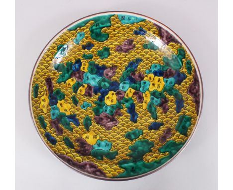
Lot 1744
A VERY UNUSUAL JAPANESE MEIJI PERIOD IMARI ENAMEL MAP OF JAPAN PORCELAIN CHARGER, the dish forms a typical Imari style that depicts a map of Japan, the sea highlighted with yellow enamel and styled as waves, the regions of Japan highlighted in different shades of green, brown and yellow, the reverse is enamelled green with formal foliage scrolling, with a yellow centre and a stylized mark. 36.9cm diameter.

Lot 260
China. Schenk (Peter) & Valk (Gerard), Imperii Sinarum Nova Descriptio. Auctore Joh van Loon, decorative title cartouche lower left, part hand coloured engraved map, Amsterdam, [early 18th century], mounted, framed and glazed 66 x 72cm overall Provenance: Property of a lady from a Normandy Manoir.清18世纪早期 《大清全图》 拍品来源:法国私人收藏
Lot 406
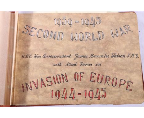
Two albums of ephemera pertaining to or collected by BBC war correspondent James Brownlee Watson, one album with cover decorated with his bullion wire "British War Correspondent" badges and titled Invasion of Europe 1944-1945, this album begins with photographs of personal in Clevedon 9th April to 19th April 1944, a caricature sketch drawn by Howell Dodd, photographs of RAF Padre holding a Church Service at Creully Air Strip July 1944, photographs of Falaise with Bernard Yuffy, Falaise to Flers images of deceased soldiers, hand drawn map detailing the journey taken, etc., the next album titled "Second World War Pacific Theatre", the first page with cloth "US War Correspondent" badge and details of the journey taken, photographs of Douglas Willie and James Watson, Operators License certificates, photograph of the USS Missouri in Tokio Bay 2nd Sept 1945, rising sun admittance card for the signing ceremony of the Japanese surrender on the USS Misourri, etc., and a third album of correspondence

Lot 1024
A collection of 20th century coloured maps with Bartholomew's examples including Aberystwyth, English lakes, New Forest etc, ordnance survey examples including Reigate and Tunbridge Wells, The Peak District etc and further assorted including Pocket Atlas of the World by J. Bartholomew (binding af), Letts's Cycling Map of 50 Miles Round London etc, with further tourist and topographical ephemera.Additional InformationAll in worn condition to varying degrees, please judge from viewing or illustrations and request additional if necessary.


Lot 942
Original Water Colour On Paper - "Bruges" Loosely Rendered Watercolour Depicting The Belgian City, Signed To Lower Right SE. Marley. 13x9 Inches. Together With A Framed Map Depicting "The Wards Of Coleman Street And Bassishaw, Taken From The Last Survey With Corrections" Framed And Glazed, Image Size 15x9 Inches.

Lot 523
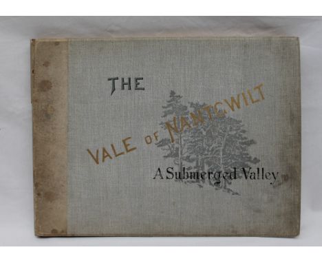
Tickell, (R. Eustace) - The Vale of Nantgwilt, a Submerged Valley, illustrative and descriptive of the Elan and Claerwen valleys in Radnorshire, shortly to be submerged by the reservoirs for the water supply of Birmingham. With twelve plates, a map of the district and a model of the watershed, printed board cover. Printed by J.S Virtue & Co, Limited, London, 1894

Lot 524
Lewis, (Samuel) A Topographical Dictionary of Wales, comprising the several counties, cities, boroughs, corporate and market towns, parishes, chapelries and townships, with historical and statistical descriptions, illustrated by maps of the different counties and a map of wales shewing the Principal towns, roads, railways, navigable rivers and canals. Volumes 1 and 2. first editions, published by S. Lewis & Co, London 1833, together with Leigh's guide to Wales and Monmouthshire, illustrated with a map of Wales, fourth edition, printed for Leigh and Son, London, 1839; Blacks picturesque guide through North and South Wales, and Monmouthshire, sixth edition, printed by Adam and Charles Black, Edinburgh, 1856, with fold out map; James,(Arthur) Handbook for Cardiff and District , prepared for the use of the British Association, printed by Daniel Owen & Company, Cardiff, 1891, first edition; A tour in Wales and through several counties of England, including both the universities, first edition, printed for Richard Phillips, London, 1806; T.J Llewellyn Pritchard, The Cambrian Balnea, or guide to the watering places of Wales, Marine and Inland, printed by John and H.L Hunt, London, 1825, and Pryse's handbook to the Radnorshire and Breconshire mineral springs, with various descriptive journeys and excursions therefrom to numerous places of interest in central Wales
-
109198 item(s)/page