We found 109182 price guide item(s) matching your search
There are 109182 lots that match your search criteria. Subscribe now to get instant access to the full price guide service.
Click here to subscribe- List
- Grid
-
109182 item(s)/page


Lot 207
'A New Map of Turkey in Europe', 'A New Map of Europe' by J. Bayly, both published by Harrison & Co. in "The Geographical Magazine 1784"; Map L'itineraire Ida Pfeiffer Voyage au tour du monde 1883, Hachette & Co., 'Planisphere du Monde de la Sphere, Mallet's Description de l'Univers; Duche de Toscane, Systeme de Descartes, Mallelt's, all 1683; Vagoundy Map of Northern Portugal, published by Gilles Robert, 1749; Map of Switzerland by J Lodge, published by C Cooke, 1810; A Map of the Earth illustrating the transit of Venus, June 6th, 1761; The Orbit of the Earth, Toms-Pluche 1747; Plan de la Ville Constantinople by Jacques-Nicolas Bellin, 1755;The Spanish Invincible Armada, Universal Magazine, 1750 for J Hinton; North Greece during Ottoman Empire by Delisle, 1794; Southern Greece, text in Latin, by Delisle, 1794; Three maps of ancient Greece from Philipp, 1711; Map of ancient Persia by Culverius, 1710; Map of ancient Greece by Santini, 1784; The World in Hemispheres with comparative heights of mountains, published by Holloway, London (15)

Lot 208
A General Map of the Caledonian Canal by W Lorimer, published by Constable, Edinburgh; Plan of Ayr Harbour, 1772, Ramsgate Harbour, 1774 and Dover Harbour all published by Longman, Hurst, Rees, Orme & Brown, London; A New and Correct Plan of all the house destroyed by the Fire of London, 1748 from the London Magazine, published by R. Baldwin; Map of England, printed for A Bell & C MacFaquar, 1794 from Encyclopaedia Britannica

Lot 209
A Map of South Eastern Asia and Northern Australia, Tonquin Annam, published in The Graphic, 1883 by Letts Son & Co.; Climats Selon les Anciens and 17th century map of Goree both by Allain Manesson-Mallet; Two Chinese Town Maps by Jacques-Nicolas Bellin; The Seat of War, map of the Black Sea; Island of Ceylon maps x 2, the Greek Archipelago, Wellington Channel, Kamtchatka, Iceland by GH Swanston, published by Archibald Fullarton, 1860

Lot 269
A 19th century 'Plan of the Parish of Rocester in the County of Stafford, Binns and Clifford, Surveyors, Union Street, Birmingham, 1839'. Rocester is a town near Uttoxeter in Staffordshire. This map is approximately 205cm by 205cm and is made of paper on fabric. The map shows other local parishes such as Denstone, Croxden etc and shows upto areas such as Clownholme. In reasonable condition with signs of staining, worm etc. Local interest to Staffordshire.


Lot 284
1974 BMW 2002 Convertible by Baur Transmission: manualMileage:86789The BMW 2002 series is important in the history of BMW for several reasons; not the least of which being that it brought the company out of near bankruptcy in the 1960’s and put BMW on the map in the United States. It was the ancestral grandfather to the BMW 3 Series and was produced from 1968 to 1976. German BMW importer Max Hoffman is credited with the car's creation. He had suggested to BMW's engineering director that a 2.0 litre engine should be installed into the small two-door 1602 to improve performance and emissions. The resulting 2002 (named after the new motor's displacement) was popular in its first year on sale.This BMW 2002 is one of only 354 examples manufactured in right hand drive format. Conversions on these outstanding vehicles were by coachbuilder Karosserie Baur in Stuttgart at a time when ‘wind in the hair’ motoring was rare. Baur retained a ‘T’ bar in the roof design helping dramatically to reduce any scuttle shake. This BMW has been owned and enjoyed by its car enthusiast vendor since 2001. This rare 2002 will require restoration but when done could provide plenty more miles of open top driving. Supplied to auction with a V5C registration document and various bills and receipts, this car is offered without reserve.Interested parties should satisfy themselves as to the description and condition of each lot prior to the sale. Accordingly, buyers are on notice that each vehicle is offered ‘as is/as seen’ subject to the Terms and Conditions for the auction. Buyers are advised to inspect the vehicle in person or use a professional to carry out this service. Historics will not entertain disputes over descriptions.


Lot 362
MAPS: COLLECTION OF ASSORTED EARLY 20TH CENTURY WORLD FOLDING MAPS, including 'Taride's Road Map of France', 'Edward Stanford Maps', 'Bartholomew's New Reduced Survey Maps', 'Daily Mail Military Map of Korea', 'Ordnance Survey Maps', 'Groom's New Map of Soudan' ETCThere are 22 Stanford maps in total.None of them have dates.1. England & Wales – Sheet 93 – Scale 1/633602. England & Wales – Sheet 94 – Scale 1/633603. England & Wales – Sheet 29 – Scale 1/633604. England & Wales – Sheet 38 – Scale 1/633605. England & Wales – Sheet 39 – Scale 1/633606. England & Wales – Sheet 119 – Scale 1/633607. England & Wales – Sheet 106 – Scale 1/633608. England & Wales – Sheet 115 – Scale 1/633609. England & Wales – Sheet 236 – Scale 1/6336010. England & Wales – Sheet 254 – Scale 1/6336011. England & Wales – Sheet 268 – Scale 1/6336012. England & Wales – Sheet 285 – Scale 1/6336013. England & Wales – Sheet 287 – Scale 1/6336014. England & Wales – Sheet 300 – Scale 1/63360 – Water Stains15. England & Wales – Sheet 319 – Scale 1/6336016. England & Wales – Sheet 357 & 360 – Scale 1/6336017. No Sheet Title – The Balkans – Scale 1/250,00018. No Sheet Title – Serbia – Scale 1/250,00019. No Sheet Title – Turkey – Scale 1/250,00020. No Sheet Title – The Balkans, Kozana – Scale 1/250,00021. No Sheet Title – The Balkans, Elbasan – Scale 1/250,00022. England & Wales – Sheet 118 – Scale 1/63360


![BLOME, Richard (1635-1705). A General Mapp of North Wales. [etc.]BLOME, Richard (1635-1705). A General Mapp of North Wal](https://cdn.globalauctionplatform.com/a3276cf8-db78-46ec-8c8b-ad5900c80e7d/87102d3c-7b8d-4629-986b-ad5900dc45ad/468x382.jpg)
Lot 531
BLOME, Richard (1635-1705). A General Mapp of North Wales. [etc.]BLOME, Richard (1635-1705). A General Mapp of North Wales … and ye Isle of Anglesey. [London: c. 1673 or later]. Fine hand-coloured engraved map, title and 6 coats-of-arms within fully-coloured baroque cartouches, galleons, 335 x 450mm, unframed. With 9 other hand-coloured engraved county maps by Richard Blome of Kent, Leicester, Oxfordshire, Staffordshire, Suffolk, Warwickshire, Worcestershire, The West Riding of Yorkshire and The North Riding of Yorkshire, all unframed. (10)
![CORNWALL - Thomas KITCHIN (1718-84). A New Improved Map of Cornwall. [etc.]Thomas KITCHIN (1718-84). A New Improved Map of Co](https://cdn.globalauctionplatform.com/a3276cf8-db78-46ec-8c8b-ad5900c80e7d/bf3a1e2e-55b9-4c36-8c59-ad5900dc2201/468x382.jpg)
Lot 549
CORNWALL - Thomas KITCHIN (1718-84). A New Improved Map of Cornwall. [etc.]Thomas KITCHIN (1718-84). A New Improved Map of Cornwall from the Best Surveys and Intelligencies Divided into its Hundreds. London: Printed for T. Bowles, [c. 1750]. Large hand-coloured engraved map, title within fully hand-coloured figural cartouche, dedication within baroque cartouche, inset map of The Isles of Scilly (browned apart from a strip an inch wide at the centrefold, some spotting and staining), 515 x 680mm., framed and glazed. With Nicolas Sanson's Provinces d' West; autrefois Royaume d' Westsex: ou sont Aujourdhuy les Comtes Hant-shire, et l' Isle de Wight, Barck-sh. Wilt-sh. Dorcet.sh. Somerset.sh. Devon.sh. et Cornwall [etc] (Paris, 1654, framed and glazed) and Blaeu's Cornubia, sive Cornwallia (Amsterdam, [c.1640], hand-coloured engraved map of Cornwall, framed and glazed). (3)
![[DRAYTON, Michael (1563-1631)]. Kent. [etc.][DRAYTON, Michael (1563-1631)]. Kent. [London: c. 1622]. Hand-coloured engra](https://cdn.globalauctionplatform.com/a3276cf8-db78-46ec-8c8b-ad5900c80e7d/f61acf06-9429-47dd-bd01-ad5900dc29ba/468x382.jpg)
Lot 555
[DRAYTON, Michael (1563-1631)]. Kent. [etc.][DRAYTON, Michael (1563-1631)]. Kent. [London: c. 1622]. Hand-coloured engraved map with allegorical figures, 255 x 345mm., framed and glazed. With 6 other maps of Kent including John Ogilby’s The Road from London to Hith [sic, i.e. Hythe, in Kent] ([London, n.d.], hand-coloured strip map) and Bayly’s A Map of the Hundreds of Toltingtrough and Shamel ([London, n.d.]), all framed and glazed. (7)
![JANSSONIUS, Johannes (1588-1664). Wiltonia [Map of Wiltshire].JANSSONIUS,Johannes (1588-1664). Wiltonia sivecomitatus Wilton](https://cdn.globalauctionplatform.com/a3276cf8-db78-46ec-8c8b-ad5900c80e7d/a49dc6cb-ce6a-4572-ba29-ad5900d13c4e/468x382.jpg)
Lot 577
JANSSONIUS, Johannes (1588-1664). Wiltonia [Map of Wiltshire].JANSSONIUS,Johannes (1588-1664). Wiltonia sivecomitatus Wiltoniensis. Anglis Wilshire. Amsterdam: “Apud JoannemJanssonium”, [c. 1660]. Hand-coloured engraved map of Wiltshire, figural titlecartouche, scale cartouche with putti, coats-of-arms, French text onverso, 398 x 495mm., unframed.
![SEUTTER, Matthaeus (1678-1757). Asia. [etc.]SEUTTER, Matthaeus (1678-1757). Asiacum omnibus imperiis provinciis. [Augsburg: 1](https://cdn.globalauctionplatform.com/a3276cf8-db78-46ec-8c8b-ad5900c80e7d/1249955b-588e-4815-a09a-ad5900da563d/468x382.jpg)
Lot 609
SEUTTER, Matthaeus (1678-1757). Asia. [etc.]SEUTTER, Matthaeus (1678-1757). Asiacum omnibus imperiis provinciis. [Augsburg: 1725]. Hand-coloured engraved mapof Asia, extending from the Mediterranean in the west to Japan in the east, andshowing part of the northern coast of Australia ("Nova Hollandia"), 2elaborate figural cartouches, 490 x 570mm, unframed. With Carel Allard’s RegniPoloniae, magni ducatus Lithuaniae ([Amsterdam, c. 1705], hand-colouredengraved map of Poland, unframed). (2)
![BARRINGTON, Daines ([?]1727-1800). Miscellanies.BARRINGTON, Daines ([?]1727-1800). Miscellanies. London: Printed by J. N](https://cdn.globalauctionplatform.com/a3276cf8-db78-46ec-8c8b-ad5900c80e7d/76fc414e-18ca-416d-90d9-ad5900e4748d/468x382.jpg)
Lot 630
BARRINGTON, Daines ([?]1727-1800). Miscellanies.BARRINGTON, Daines ([?]1727-1800). Miscellanies. London: Printed by J. Nichols, 1781. 4to (269 x 208mm). Woodcut device on title, engraved portraits of Mozart and Sir John Wynne, folding engraved "Map of Europe for the Illustration of King Ælfred's Anglo-Saxon translation of Crosius" and "North Part of the Great Sea Pacific Ocean" including California, engraved music, tables, including one folding (variable mainly marginal spotting and staining). Contemporary speckled calf, spine gilt with red morocco lettering-piece (joints split, rubbed and scuffed, upper cover nearly detached). Provenance: James Brodie of Brodie (armorial bookplate); from the Collection of Lt. Cdr. Andrew David (bookplate). FIRST EDITION of this diverse, and diverting, collection of essays by an English lawyer, antiquary and naturalist. Their titles include "Tracts on the Possibility of reaching the North Pole", "Whether the Turkey was known before the Discovery of America", "On the sudden Decay of several Trees in St. James Park", "Account of Mozart, a very remarkable young Musician", "Some Account of Little Crotch" [the English musical prodigy William Crotch (1775-1847) who would have been five- or six-years-old at the time of writing] and "Journal of a Spanish Voyage in 1775, to explore the Western Coast of N. America." Bell B61; Cox II, 25; Hill 56; Howes B177; Sabin 3628; Wagner Northwest Coast 674; Streeter IV, 2445; Wickersham A Bibliography of Alaskan Literature 1724-1924 6653.
![FINDLAY, Alexander George (1812-75). A Directory for the Navigation of the Pacific Ocean. [etc.]FINDLAY, Alexander George (18](https://cdn.globalauctionplatform.com/a3276cf8-db78-46ec-8c8b-ad5900c80e7d/d895df9f-755b-427b-af80-ad5900d0cbf4/468x382.jpg)
Lot 636
FINDLAY, Alexander George (1812-75). A Directory for the Navigation of the Pacific Ocean. [etc.]FINDLAY, Alexander George (1812-75). A Directory for the Navigation of the Pacific Ocean; withDescriptions of its Coasts, Islands, etc., from the Strait of Magalhaens to theArctic Sea, and those of Asia and Australia; its Winds, Currents and OtherPhenomena. London: R. H. Laurie, 1851. 2 volumes, large 8vo (237 x 150mm).Double-page engraved map printed in blue and black, publisher’s advertisingslip inserted before title of vol. one, tables (title of vol. one torn withoutloss). Contemporary blue half roan gilt (joints splitting, extremities rubbed).Provenance: United Services Club (label). FIRST EDITION. With 3 otherworks of related interest, namely George Back’s Narrative of the Arctic Expeditionto the Mouth of the Great Fish River, and along the Shores of the Arctic Ocean(Philadelphia, 1836, folding engraved map, modern buckram), M. Russell’s Polynesia:Or, an Historical Account of the Principal Islands in the South sea, includingNew Zealand … Second edition (Edinburgh, 1843, original cloth) and ThomasBoyles Murray’s Pitcairn: The Island, the People, and the Pastor … EighthEdition (London, 1857, modern half calf). Provenance: from theCollection of Lt. Cdr. Andrew David (bookplate). (5)
Lot 638
FRANKLIN, John (1786-1847). Narrative of a Journey to the Shores of the Polar Sea.FRANKLIN, John (1786-1847). Narrative of a Journey to the Shores of the Polar Sea, in the Years1819, 20, 21, and 22 … With an Appendix on Various Subjects relating to Scienceand Natural History. London: John Murray, 1823. 4to (285 x 220mm). 20 engraved platesand 11 hand-coloured aquatint plates, 4 folding engraved maps at the end, onehand-coloured in outline (title and first plate [bound as frontispiece]spotted, some mainly marginal spotting and staining, first map laid down onlinen [?as issued]). Modern half calf gilt. Provenance: C. L. Lloyd(inconspicuous modern signature at head of title); from the Collection of Lt.Cdr. Andrew David (bookplate). FIRST EDITION. The plate count for this work isusually just 30 plates; the final hand-coloured natural history plate in thiscopy, engraved by J. Swan [illustrated], may be inserted from another work. Abbey Travel 635;Arctic Bib. 5194; Graesse II, 630; Hill 635: “Franklin’s narrative at oncebecame a classic of travel literature”; Lande 1181; Nissen ZBI 1419;Sabin 25624.
Lot 653
SEEMAN, Berthold Carl (1825-71). Narrative of the Voyage of H.M.S. Herald ... Being a Circumnavigation of the Globe, and Three Cruizes [sic] of the Arctic Regions in Search of John Franklin.SEEMANN, Berthold Carl (1825-71). Narrative of the Voyage of H.M.S. Herald during the Years 1845-51, under the Command of Captain Henry Kellett, R.N., C.B., being a Circumnavigation of the Globe, and Three Cruizes [sic] of the Arctic Regions in Search of Sir John Franklin. London: Reeve and Co., 1853. 2 volumes bound in one, large 8vo (212 x 140mm). Half title to vol. one, 2 tinted lithographed frontispieces, folding coloured map with route of the voyage marked in red, tables (lacks all before half title [i.e. endpaper], half title browned, occasional light spotting and staining). Original mauve pebbled pictorial cloth gilt, gilt edges (extremities rubbed, some staining, mark to upper cover). Provenance: Hudson (armorial bookplate); from the Collection of Lt. Cdr. Andrew David (bookplate). FIRST EDITION. Arctic Bib. 15680; Hill p. 271; Howes S-271; Sabin 78867; Stafleu and Cowan TL-2 11602; Wickersham 6593.
![SEEMAN, Berthold Carl (1825-71). Viti: An Account of a Government Mission to the Vitian or Fijian Islands. [etc.]SEEMANN, Ber](https://cdn.globalauctionplatform.com/a3276cf8-db78-46ec-8c8b-ad5900c80e7d/ca02edc9-6f5a-4026-9cdd-ad5900d84875/468x382.jpg)
Lot 654
SEEMAN, Berthold Carl (1825-71). Viti: An Account of a Government Mission to the Vitian or Fijian Islands. [etc.]SEEMANN, Berthold Carl (1825-71). Viti: An Account of a Government Mission to the Vitian or Fijian Islands in the Years 1860-61. Cambridge: Macmillan & Co., 1862. 8vo (224 x 140mm). Half title, tinted lithographed frontispiece, double-page engraved map, and 3 tinted lithographed plates (some light mainly marginal spotting and staining). Modern green half morocco gilt, new endpapers. FIRST EDITION. Howgego III, 516. With Joseph Waterhouse’s Vah-ta-ah, the Feejeean Princess: with Occasional Allusions to Feejeean Customs; and Illustrations of Feejeean Life (London, 1857, original cloth). Provenance: from the Collection of Lt. Cdr. Andrew David (bookplate). (2)
![SMYTH, William (1800-77) & Frederick LOWE (1811-47). Narrative of a Journey from Lima to Para [sic], Across the Andes and](https://cdn.globalauctionplatform.com/a3276cf8-db78-46ec-8c8b-ad5900c80e7d/44d06990-9b8c-4a80-8afb-ad5900d8520d/468x382.jpg)
Lot 655
SMYTH, William (1800-77) & Frederick LOWE (1811-47). Narrative of a Journey from Lima to Para [sic], Across the Andes and Down the Amazon.SMYTH, William (1800-77) and Frederick LOWE (1811-47). Narrative of a Journey from Lima to Para [sic], Across the Andes and Down the Amazon: Undertaken with a View of Ascertaining the Practicability of a Navigable Communication with the Atlantic, by the Rivers Pachitea, Ucayali, and Amazon. London: John Murray, 1836. 8vo (225 x 140mm). Lithographed frontispiece, wood-engraved vignette on title, 10 lithographed and wood-engraved plates, folding engraved “Plan of the Rivers Ucayali and Amazon”, 14-pages of publisher’s advertisements at the end (plates and map quite heavily stained and browned with some offsetting onto text leaves, some mainly marginal staining to text). Modern half calf gilt, new endpapers. Provenance: from the Collection of Lt. Cdr. Andrew David (bookplate). FIRST EDITION.
Lot 660
WILLIAMS, Thomas (1815-91). Fiji and the Fijians.WILLIAMS, Thomas (1815-91). Fiji and the Fijians … Edited by George Stringer Rowe. London: Alexander Heylin, 1858. 2 volumes, 8vo (185 x 120mm). Half title in vol. II, folding engraved map, 12 plates, 3 of which coloured, one-page of publisher’s advertisements at the end of vol. II (plates generally spotted, some light spotting and staining to text). Original peach cloth decorated in blind (spines discoloured, inner hinges weak or broken, stained). Provenance: Henry Hannen (armorial label); from the Collection of Lt. Cdr. Andrew David (bookplate). FIRST EDITION. Abbey Travel 603; Hill p. 1885. (2)

Lot 384
TOMASI DI LAMPEDUSA GIUSEPPE: (1896-1957) Italian Writer, the last Prince of Lampedusa. Rare signed and inscribed book by Lampedusa, being a 4to paperback edition of the book En Sicile by Gabriel Fauré, in French. Signed and inscribed in Italian by Tomasi di Lampedusa to the title page `To my very dear Guido, twenty years have passed, but always with the same affection, Giuseppe´, also dated 21st July 1951. The 200 pages edition, published by B. Arthaud in 1951, numbered 505, includes 181 gravures showing images of Sicily. s, 1917. Lampedusa dedicates the book to his close friend Guido Lajolo, with whom he served in the same regiment during World War I. The book includes a separate map of Sicily. Overall age wear with foxing stains to the covers. Some age toning to the edges of the pages. G
Lot 441
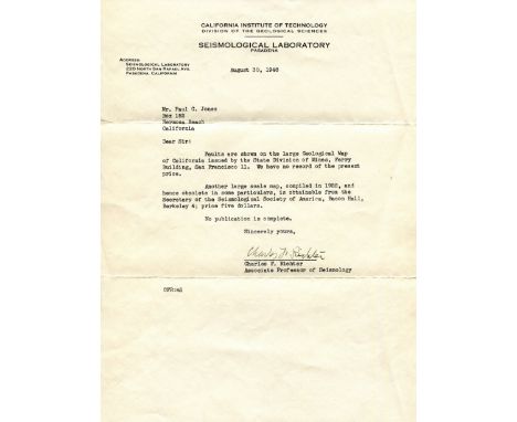
RICHTER CHARLES F.: (1900-1985) American Seismologist & Physicist, creator of the Richter magnitude scale. A rare T.L.S., Charles F. Richter, one page, 4to, Pasadena, California, 30th August 1948, to Paul C. Jones, on the printed stationery of the Seismological Laboratory at the California Institute of Technology. Richter writes, in part, 'Faults are shown on the large Geological Map of California issued by the State Division of Mines…..Another large scale map, compiled in 1922, and hence obsolete in some particulars, is obtainable from the Secretary of the Seismological Society of America…..' Accompanied by the original envelope. One extremely small, minor tear to the left edge of a fold, otherwise VG

Lot 546
SIKORSKI WLADYSLAW: (1881-1943) Polish Lieutenant General of World War II, Prime Minister of Poland 1922-23, 1939-43. An unusual 4to sheet of feint graph paper with various neat and attractive ink annotations commemorating Sikorski, and featuring a montage incorporating a magazine image of the Lieutenant General in a head and shoulders pose wearing his uniform and a map of Poland with the caption Long Live Poland. At the base of the map, in the centre of the page, Sikorski has signed his name in bold blue fountain pen ink, adding the words and date Prime Min. of Poland, London, 26.IX.42 in his hand beneath. An attractive presentation. VG


Lot 107
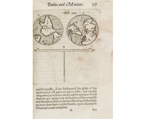
Ridley (Mark) A Short Treatise of Magneticall Bodies and Motions, first edition, second issue with X3 cancelled and containing errata, with first and last blanks, engraved architectural title by Elstrack showing planets and scientific instruments, engraved portrait on a4v, woodcut initials, head-pieces and printer's device at end, 21 engraved and one woodcut diagrams and illustrations, some full-page, one with volvelle (pasted down), damp-stained throughout with purple mildew but stabilised and restored, a few minor tears and repairs (mostly marginal), resewn and recased in old vellum wrapper (part of a contemporary manuscript indenture), also stained, [Honeyman VI 2649; Sabin 71297; STC 21045.5], small 4to, Nicholas Okes, 1613.⁂ An important work in the history of experimental science in England, and the most important work on magnetism after William Gilbert's De magnete. "Ridley gives directions for carrying out experiments on the lodestone, magnet, and terrella. He includes numerous engravings and descriptions of his improved instruments for determining the declination of the magnetic needle and for making use of the inclinatory needle for finding position at sea" (ODNB). There is also a map showing New England, Virginia, and Terra Australis.
Lot 157
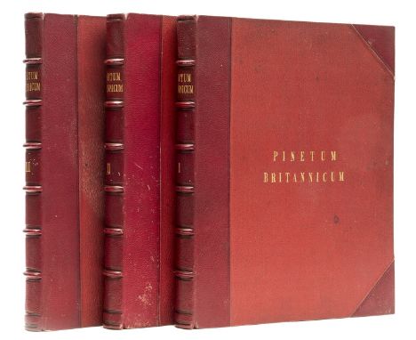
Arboriculture.- Ravenscroft (Edward) The Pinetum Britannicum. A Descriptive Account of Hardy Coniferous Trees, 3 vol., first edition, 48 hand-coloured lithographed plates, 4 mounted albumen prints, 1 engraved map, errata slip, foxing, almost exclusively affecting the text but not plates, contemporary red half morocco, covers lightly stained, a little rubbed, folio, [Nissen BBI 1588], 1884.⁂ This stunningly illustrated work was the result of over twenty years of collaboration and research. The tree portraits in colour are predominantly from the original drawings of William Richardson, those of cones and leaves by Dr Greville and James and Robert Black, and the characteristic sketches of the Deodar Cedars in vol. 3 were captured 'in the field' by Lady Canning during her time in India. The extensive woodcut illustrations throughout the text were also executed by multiple hands; Andrew Murray, James M'Nab, Dr Greville and Dr Maxwell T Masters. Meanwhile, leading conifer specialists of the day, from institutions such as the British Museum, Royal Horticultural Society and Royal Botanical Gardens, as well as individual professors from Florence, Berlin and Paris, and several private experts, all contributed to enhance the publication. On its commencement in 1863, the project received immediate royal support; Queen Victoria requested the work be dedicated to the memory of the recently deceased Prince Albert and provided photographs of two specimens at Osborne House for inclusion, while Emperor Napoleon III secured thirty copies for distribution among French schools of Forestry and Agriculture. Considered one of the great British works on coniferae, the Pinetum Britannicum is a testament to the nineteenth century fascination with natural history and fashion for classifying and cataloguing, and remains unmatched in scope and quality.
![Ptolomaeus (Claudius) Geographiae libri octo, edited by Gerard Mercator, second edition, collation: []2 A-L6, M4, (?)4, A-L2,](https://cdn.globalauctionplatform.com/65d8a6eb-dfaf-49c0-9249-ad4e00f63bf4/ec857183-34de-490b-8325-ad4e01092703/468x382.jpg)
Lot 181
Ptolomaeus (Claudius) Geographiae libri octo, edited by Gerard Mercator, second edition, collation: []2 A-L6, M4, (?)4, A-L2, K2, M-O2, N-Z2, Aa-Bb2, a-b6, c4 (lacking final blank c4), engraved title and 28 engraved maps, all but Egypt double-page, but that of Egypt bound horizontally and thus appearing double-page and smaller, woodcut illustrations, decorations and initials, title with marginal soiling, last map with marginal defect, occasional minor soiling, modern calf, folio, Cologne, Godfried von Kempen, 1584.⁂ The second edition of Mercator's version of Ptolemy, which first appeared in 1576. An important 16th century work, representing Mercator's life-time fascination with Ptolemy and, more broadly, the Renaissance's continued negotiation with the classical past. In order to produce this book, Mercator edited and revisited Ptolemy's Geography, which had been rediscovered in a Greek version in the 14th century and then translated into Latin. Though Ptolemy gave detailed instructions and coordinates in the work as to how maps should be prepared, none are known from classical example. Mercator therefore went through the Latin text carefully, trying to ensure that he obtained the best and truest possible version and drew up the maps from it according to Ptolemy's specifications. The result is this important and attractive work.Literature: VD 16 P 5219
Lot 223
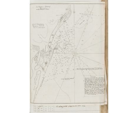
Royal Navy.- Malcolm (George John, Rear-Admiral, 1830-84) Log of the Proceedings of H.M.S... Inconstant... Curacoa... Firebrand..., autograph manuscript, titles and c. 380pp., numerous monochrome wash watercolour slips of coasts and pen and ink maps (including a map of Pernambuco, Brazil), slightly browned, original calf, repaired, folio, 1842-46.⁂ Places visited include: Spain (Tarifa), Straits of Gibraltar, Funchal (Madeira), west coast of Africa, Brazil (Pernambuco), Uruguay ("Plan of the Harbour of Monte-Video") and Argentina (Buenos Ayres Mole").Malcolm was the eldest son of Sir Charles Malcolm (1782-1851), naval officer. He followed in his father's footsteps, serving in the Royal Navy for his entire career and becoming Rear Admiral in 1882. His long naval career took him to North and South America, the West Indies, the Baltic, the English Channel, Egypt, and the East Coast of Africa. After he retired from active service in 1873, he entered the Turkish services as Pasha and was employed at Constantinople as Director General of the Abolition of the Slave Trade and Judge of the Slave Courts.
![Bible, English.- [The Holy Bible, Conteyning the Old Testament, and the New: Newly translated out of the Originall Toungues],](https://cdn.globalauctionplatform.com/65d8a6eb-dfaf-49c0-9249-ad4e00f63bf4/bb5ed892-d7b7-4782-9ec3-ad4e01097a62/468x382.jpg)
Lot 254
Bible, English.- [The Holy Bible, Conteyning the Old Testament, and the New: Newly translated out of the Originall Toungues], woodcut illustrations, initials and head- and tail-pieces, double page map, double column in blackletter 72 lines, Kalendar in red and black, lacking general title but with New Testament title within woodcut border, lacking 6 initial ff. (all before B2, and B4) and final 4ff., some spotting and staining throughout, initial and final leaves heavily creased or defective at margins, several loose, contemporary boards, all leather missing, binding stitching largely present, corners worn, [STC 2226, Herbert 322], [Robert Barker], folio, [1613].⁂ An example of the 'She-Bible' version of the King James Bible, distinguishable from the other folio version of 1613 by its smaller type in 72 lines per column. The She-Bible nomenclature stems from the typographical difference in Ruth 3:15 between early printings of the King James Bible, in some the verse reading 'and she went into the city', while in others it is 'he' who went into the city, known as the 'He-Bibles'. This discrepancy, being the most famous of several such examples, has sparked comment ever since. The desired rapidity and quantity of the print roll out of the King James Bible led Barker, whose family had previously been granted monopoly of royal authorised bible production by Elizabeth I, to subcontract printing out to two further publishing houses, soon resulting in dispute and fervent competition. Thus, it has often been assumed that the She-Bibles are the result of a 'correction' by a typesetter, compositor or proof-reader at some point during the printing process in one or other of the presses; 'she' seems to make more sense in the narrative flow and subsequently became the dominant translation. Such interpretation supports the view that the editio princeps is indeed the He-Bible, but not necessarily as is often consequently thought, because the male pronoun is an original error. Considering the biblical text of Ruth 3:15 in its ancient languages is also obscure since Hebrew and Syriac manuscripts, the Greek Septuagint and Latin Vulgate offer alternative translations. The 40 or so biblical scholars responsible for the King James Old Testament, however, based their efforts on the Masoretic Hebrew texts (the canonical Hebrew as established c.1000AD), which provide the strongest support for the male 'he' translation. Thus the He and She-Bible phenomenon offers scholars of biblical history and book production a continuing historical mystery, touching as it does upon unanswerable questions over the complex material production process of the King James Bible, as well as upon an ancient query of translation.

Lot 256
Bible, English.- The Bible: Translated according to the Hebrew..., woodcut general and New Testament titles, woodcut illustrations, initials and head- and tail-pieces, double column in blackletter, lacking 2M8, 2N1 upper corner defective with loss of some text, 2N5 and 2R4 with marginal tears but no loss of text, a few manuscript prayer annotations, [STC 2241, D&M 340], Robert Barker, 1615 issued with R.F.H, Two profitable and fruitful Concordances, double-page map, Robert Barker, 1615 bound after The Book of Common Prayer, title a little creased, heavily trimmed, affecting headlines and side notes, [Wing B3612], Robert Barker, 1641 bound with The Whole Book of Psalms, worming with slight loss of text, [Wing B2452A], for the Company of Stationers, 1653, some light foxing, soiling and staining throughout, contemporary calf, rebacked with original spine laid down, covers and extremities worn, 4to.
Lot 28
Africa.- Hoskins (G. A.) Travels in Ethiopia, above the Second Cataract of the Nile, first edition, folding engraved map, 53 lithographed plates, 2 hand-coloured, 4 chromolithographed, several folding or double-page, wood-engraved illustrations, small stain to frontispiece and title, map lightly browned and torn & repaired at folds, Ricardo A.Caminos copy with his small ink stamps to dedication, modern morocco-backed buckram by Sangorski & Sutcliffe, spine faded, 4to, 1835.⁂ Ricardo A.Caminos (c.1916-92), Argentine Egyptologist who worked particularly on epigraphy and palaeography.
Lot 30
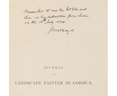
Mediterranean.- Lear (Edward) Journal of a Landscape Painter in Corsica, first edition, presentation copy from the author inscribed "Presented to me by Mr. Edward Lear on his departure from India on the 16th July 1874. J.M.Boyd" on half-title, 40 wood-engraved plates, wood-engraved map and illustrations, occasional spotting, modern black morocco, tan calf label, large 8vo, 1870.⁂ Probably Lieutenant Colonel J.M.Boyd, who served in Abyssinia and the Second Anglo-Afghan War in 1880, taking part in the march from Kabul to Kandahar under General Roberts in August 1880. He was also an accomplished amateur watercolourist which would explain the gift from Lear.
Lot 32
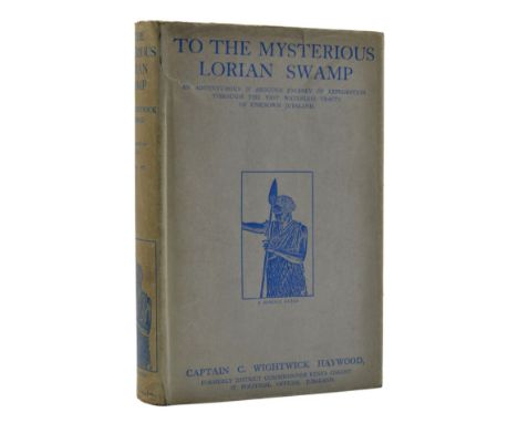
*** Please note the description of this lot has changed.Africa.- Haywood (Capt. C. Wightwick) To the Mysterious Lorian Swamp, first edition, photographic frontispiece and 15 plates, folding map, 12pp. advertisements, original pictorial cloth, gilt, dust-jacket, light toning to spine, a few short repaired tears to head and foot with some light creasing, a very good example overall, 1927.⁂ Rare in the dust-jacket. Sporting adventure in Jubaland, now Somalia, in which the author killed a rhino with an automatic pistol when it charged at him as he was taking a photograph. "[I]t is not the sort of effort I care to repeat...".
-
109182 item(s)/page