We found 109182 price guide item(s) matching your search

Refine your search

Year

Filter by Price Range
  • List
  • Grid
  • 109182 item(s)
    /page

Lot 185

Phillips, Richard (Sir) 1806 A Map of the Country from Rariton River in East Jersey, to Elk Head in Maryland, Shewing the Several Operations of the American & British Armies, in 1776 & 1777 A fine Revolutionary War plan covering the area between Elk Head and northeast to Trenton and on to New Brunswick, New Jersey. The map details troop positions, particularly those of General Irvine along the Delaware River on the opposite shore from Trenton, and locates scores of towns and villages. Engraved by Neele. 15.3"" W x 9.9"" H Issued folding with a printer`s crease near the center.

Lot 186

Johnson, A. J. 1862-64 [Lot of 2] Johnson`s Map of the Vicinity of Richmond, and Peninsular Campaign in VirginiaÂ… [and] Johnson`s Virginia, Delaware, Maryland & West Virginia ""A. Johnson`s Map of the Vicinity of Richmond, and Peninsular Campaign in Virginia. Showing Also the Interesting Localities Along the James, Chickahominy and York Rivers..., dated 1862 (26.6 x 17.9""""). A very interesting Civil War map that was compiled from the Official Maps of the War Department. This well-engraved map covers the region of the James, Chickahominy and York Rivers, and includes the cities of Norfolk, Richmond, and Petersburg. The map shows great detail of military movements, lines and fortifications. It notes the location of the """"contest"""" between the Monitor and Merrimac on 9 March 1862, the Confederate evacuation of Yorktown, May 4 1862, the battle in the vicinity of Williamsburg, May 5 1862, the battle of Malvern Hill and several other military engagements in the vicinity of Richmond. Condition: There are a few tiny edge tears and light toning along the top edge of the sheet. Narrow margins as issued. (B+) B. Johnson`s Virginia, Delaware, Maryland & West Virginia, dated 1864 (23.2 x 17.0""""). A very graphic and attractive double-page map filled with detail of railroads, roads, towns, villages and topographical information. With a large vignette birds-eye-view of Fort Monroe and the University of Virginia. Decorative borders. Condition: Faint toning along the centerfold with a centerfold separation at bottom confined to the blank margin. (A)"" "" W x "" H See descriptions above.

Lot 187

Magnus, Charles 1863 One Hundred and Fifty Miles Around Richmond. Eastern Army Guide This scarce Civil War map focuses on the center of action in Virginia. It covers the region from Baltimore south to Raleigh and from the Chesapeake Bay to Lexington, Virginia. Details include roads, railroads, cities, courthouses, rivers and topography. The map is attached to its original stiff boards and includes an 1863 almanac (calendar) and a hand-colored song sheet entitled ""The Captain With His Whiskers"" which came with the 5.5 x 8.5"" portfolio. The front cover gives a list of the contents which includes these described items only with a note ""Almanac for 1863 Gratis"" which helps to positively date the map. Stephenson does not list this edition, but the 1863 date and lack of inset maps and illustrations around the map itself likely make this an early edition. As stated on the cover, this portfolio and its contents were "" published for the Union soldiers by Charles Magnus."" 22.4"" W x 22.3"" H The map has scattered foxing and staining with a few tiny splits at fold intersections that have been closed on verso with archival tape. Covers have light wear and stains.

Lot 188

U.S. Coast & Geodetic Survey, 1904 Chesapeake Bay Maryland and Virginia This large format map, printed and joined on two sheets, shows incredible detail of the Chesapeake Bay from Norfolk, Virginia north to Havre de Grace, Maryland. The chart extends west and north following the James, Potomac and Patapsco Rivers to Richmond, Washington D.C. and Baltimore respectively. The bay is filled with soundings and buoys while lighthouses are noted along the coast at Cape Charles, Cape Henry and Hog Island. A stamp at bottom notes that while the map is dated 1904, it has been corrected to 1906 with ""Aids to Navigation corrected for information received to August 27, 1906."" 31.9"" W x 63.1"" H There is a small area of loss at bottom right and one short edge tear at top confined to the blank margin and closed on verso with archival tape. Otherwise a nearly fine example.

Lot 189

U.S. Corps of Engineers, 1925 Air Navigation Map No. 46 (Experimental) Washington, D.C. to Middletown, PA. ""In 1921, the United States Army Air Corps initiated a compressive evaluation of aeronautical charts in an effort to develop a standardized map for aerial navigation. Based upon this study, the Air Corps issued 63 air navigation maps covering most of the military routes in the United States. Prior to 1926, these maps were jointly compiled by the Geological Survey and U. S. Army Engineer Reproduction Plant. By 1926, the preparation of air maps shifted to the U.S. Coast and Geodetic Survey (under the Commerce Department) with the passage of the Air Commerce Act. Maps from this point on were intended to merge the growing commercial airways system with the military network. This map covers the area from Washington D.C. to Middletown, Pennsylvania (near Harrisburg) and shows elevation and contours, cities and towns, rivers, roads and railroads. Airfield classifications are shown with different symbols including seaplane landings. True north and magnetic north are depicted. On a scale of 8 miles per inch."" 10.2"" W x 19.5"" H A colorful example with some minor toning. Backed in linen. Ex-library stamp on verso.

Lot 190

Blunt, Edmund 1815 The Bay of Chesapeake, from Its Entrance to Baltimore This chart details the Chesapeake Bay from the Currituck Inlet north to Baltimore. It is filled with shoals and soundings, many of which extend into the James, York and Potomac Rivers. The map is oriented with north to the right and shows both true and magnetic North. Issued in the eighth edition of the Coast Pilot. 17.2"" W x 7.2"" H Issued folding and now flattened and backed with tissue to reinforce and repair a tear that enters 3"" into map at left. Remargined at left with a small portion of neatline in facsimile. Occasional toning and light soiling, primarily along the folds.

Lot 191

Railroad Companies, (Various) 1835 Map and Profile of the Route of the Wilmington and Susquehanna Railroad... This rare, early railroad survey was compiled by J. Trautwine under the direction of W. Strickland and published in the Journal of the Franklin Institute. The map covers the route of this proposed railway from Wilmington, Delaware to Charlestown, Maryland. Detail includes waterways, roads, villages and towns, and structures with ownersÂ’ names. The map was lithographed by Lehman & Duval Lith. and has a scale of 1 inch to a mile. 27.2"" W x 7.4"" H Issued folding on a bright sheet which has been remargined at right to repair a few edge chips and tears with very minor loss of neatline. Faint toning along one fold.

Lot 192

Hondius, Jodocus 1619 Virginiae Item et Floridae Americae Provinciarum, Nova Descriptio This stunning map was compiled from two of the most important source maps of the early colonial period: John White`s Virginia and Jacques le Moyne`s Florida. Hondius` map became the prototype map of the region for the first half of the 17th century and continued to influence the cartography of the region until the middle of the 18th century. Largely due to the enormous success of Hondius` Atlas, Le Moyne`s erroneous depiction of a large inland lake (Lacus aquae dulcis) from which the R. de May (St. John`s River) flows in a southeasterly direction was popularized. Chesapeake Bay, here called Chesepioock Sinus, and the area south towards C.S. Romano Hispanis are shown in their White delineations. The Indian villages of Paquiwok, Croatoan, and Wococon are named in the Outer Banks and several others along the Albemarle and Pamlico Sounds. The map is extensively decorated with depictions of Indian villages incorporated in the title cartouche, a Floridian king and queen and Virginian natives in a canoe taken from De Bry, wildlife including a wild turkey, ships, sea monsters and a superb compass rose. French text on verso. 19.1"" W x 13.5"" H A nice impression with full original color, light overall toning, minor color offsetting, and a crease adjacent to centerfold.

Lot 194

Homann Heirs, 1740 D. Carolina nebst Einem Theil von Florida This map details the roads, forts, towns, and coastal shoals between the mouth of Chesapeake Bay to The South Bounds of Carolina according to the last Charter, which is in present-day Florida just south of St. Augustine. It extends inland to just west of the Apalaxy R. (Apalachicola River) and north to two battlefields of the Tuscarora War. The map was based off of Moll`s map from Atlas Minor, circa 1729. As in Moll`s map, the region of present-day Georgia is labeled Azilia for the aborted ""Margravate of Azilia"" of Sir Robert Montgomery. Seluda Desert, a remnant of the misconceptions perpetuated by John Lederer is also shown. Many of Moll`s notations throughout the map have been translated into German and Latin. Several additions have also been made, including Ebenezer of the Salzb. at the mouth of the Savannah River, and Fort Col Angile (Argyle) near the mouth of the Howgeche (Ogeechee) River. This map was one of four separate maps printed on one sheet, titled Dominia Anglorum in America Septentrionali, showing the British possessions in North America based on Moll. 10.8"" W x 8"" H Professionally remargined with old paper at top, left, and right, with neatline at left replaced in facsimile. A nice impression with one tiny hole in border at right and an abrasion near the southern border of Carolina with a small portion of the image

Lot 195

Bonne, Rigobert 1780 Carte de la Partie Sud des Etats Unis de l`Amerique Septentrionale Attractive and concise copper-engraved map that covers the states of Virginia, North and South Carolina, and Georgia in the new United States. All settlement is confined east of the Appalachians with les Cherokees the only note in the otherwise blank region west of the mountains. There are four distance scales located on the left side of the map. 12.3"" W x 8.3"" H There is faint offsetting and a few small stains in the image. To the right of the title are a small hole and 0.5"" tear that have been closed on verso with archival tape.

Lot 196

Lodge, John 1780 A New and Accurate Map of North Carolina, and Part of South Carolina, with the Field of Battle between Earl Cornwallis and General Gates This scarce map of the Carolinas, published during the American Revolution, is apparently based on Henry Mouzon`s 1778 foundation map of the region. It is filled with topographical notes and the locations of important plantations, court houses, meeting houses, swamps, and chapels. This map illustrates the region involved in the southern theater of the war. After General Clinton seized Charleston in May of 1780, the British began a campaign into the Carolinas in pursuit of the remnants of the Continental Army. The map illustrates the Battle of Camden in August, 1780, where the American General Gates was defeated by British General Cornwallis. Includes two pages of related text describing the conflict. 15"" W x 10.8"" H Issued folding and now flattened with faint offsetting and light soiling along a professionally repaired fold separation that enters 1"" into map at top. There are a few tiny holes at fold intersections, only visible when held to light.

Lot 198

Rochefoucald Liancourt, Francois Alexander 1800 Carta delle Provincie Meridionali degli Stati-Uniti This is a very uncommon Italian map of the southeastern region. The map covers the states of Kentucky, Virginia, Tennessee, North and South Carolina, and part of Georgia. It provides a nice view of early settlements and roads, as well as the mountains, forests, and Indian villages. Between Tennessee and Georgia is a long strip of land labeled Territorio degli Stati Uniti. This land originally belonged to South Carolina but was ceded back to the United States in 1787, subject to Indian occupancy. Numerous Indian villages are shown, especially in the region of present-day Alabama. This map is from either an Italian edition of Francois la Rochefoucald Liancourt`s Travels through the United States of North AmericaÂ… or Carlo Botta`s Storia della Guerra dell` Independenza Degli Stati Uniti d`America. Howes does not list an Italian edition of La Rochefoucald Liancourt`s book, but this map is a copy of his map. 19"" W x 13.5"" H Issued folding with very faint printer`s ink residue and some minor edge tears, well away from image.

Lot 199

Phillips, Richard (Sir) 1800 Map of the Southern Provinces of the United States Interesting map covering all of the Carolinas with parts of Virginia, Kentucky, Tennessee, and Georgia. Great detail of early roads and settlements. Between Tennessee and Georgia is a long strip of land labeled United States Territory. This land originally belonged to South Carolina but was ceded back to the United States in 1787. Numerous Indian villages are shown, especially in the region of present-day Alabama. Engraved by John C. Russell. 19.9"" W x 13.6"" H Issued folding with a binding trim that extends to the neatline at left and a short binding tear just entering the map that has been closed on verso with archival tape. There is also a hint of offsetting.

Lot 200

Marshall, John 1807 Theatre des Operations les Plus Importantes de l`Armee du Sud, dans la Virginie, dans les Deux Carolines, et dans la Georgie This map extends from north of Richmond, Virginia, to Savannah, Georgia, and depicts the southern theater of the Revolutionary War. Towards the end of the war, the British shifted their attention towards the southern colonies, and succeeded in seizing control of several important port cities, including Savannah and Charleston. The map depicts towns, roads, rivers, mountains and important battle sites, including the Battle of Cowpens, shown at left. This map appeared in the French edition of Marshall`s Life of Washington. 10.2"" W x 14.1"" H On watermarked paper with the margin trimmed close to the neatline at left and a hint of offsetting.

Lot 201

Duval, Pierre 1682 La Floride While the composition of this map is based on Sanson`s famous map of 1657, Duval has given prominence to the Rio del Spiritu Sto over the other rivers flowing into the Gulf of Mexico. La Caroline is named on the R. de May, and the French claim to the region is shown as Floride Francoise. This is the third state, with Charlesford renamed Charlesfort. Pierre Duval was Nicolas Sanson`s nephew and pupil. He published a wide range of atlases and individual maps including a fine miniature world geography with many of the maps based on Sanson. 4.8"" W x 3.8"" H A fine impression with attractive color on watermarked paper and light toning along the centerfold.

Lot 202

Aa, Pieter van der 1729 La Floride, Suivant les Nouvelles ObservationsÂ… This splendid map of the southern United States was based on Delisle`s influential Carte du Mexique de la Floride of 1703. The map is filled with details of early colonial settlements and Indian tribes. The large lake first found on Le Moyne`s 1591 map is here called Lac Grande and it is land-locked. The Mississippi is shown too far west of its true course and the Apalachicoli River flows from a large spurious lake in present day Tennessee. Details of the Bahamas are included. The Gulf of Mexico is filled with a large cartouche featuring Native Americas and an incongruent lion. The entire map is enclosed in a unique large picture frame-style border. 16"" W x 13.2"" H A fine impression on watermarked paper with two tiny tears in bottom blank margin, not affecting map. Small manuscript ink page number in lower right corner.

Lot 203

Gibson, John 1763 A Map of the New Governments, of East & West Florida This map was published in November 1763 just a few weeks after the British acquisition of Florida at the conclusion of the French and Indian War. The region was divided into two British provinces, East and West Florida. The division was along the Apalachicola River, the boundary line for the Royal Proclamation of 1763 that extended from the Ohio River to Florida along the watershed of the Appalachian and Allegheny Mountains. The Proclamation was designed to reduce confrontation between Indians and colonists by outlawing English settlement west of the line. East Florida encompassed primarily the Florida peninsula; West Florida included the Gulf Coast region from the Apalachicola River to the Mississippi River south of 31° of latitude. The map locates many settlements, swamps, and rivers. Southern Florida is split by many waterways, giving the appearance that it`s made up of numerous small islands. A large inset, Plan of the Harbour and Settlement of Pensacola, provides good detail of the Bay of Sta. Maria Galres (now Pensacola Bay) complete with soundings and a compass rose. 9.9"" W x 7.6"" H Issued folding, now pressed flat, with some faint soiling.

Lot 204

Harrison, John 1788 Map of Louisiana from D`Anville`s Atlas This is the English version of D`Anville`s 1732 Carte de la Louisiane, drawn by Haywood and engraved by Bowen. The map focuses on the Mississippi delta, showing the Red River as far as Adayes, a Spanish garrison of the Province of Tecas. The coastal area extends in the east from Cape San Blas and Apalachicola Bay (C. Escondido) to an area named Cabo del Norte shown with a small island off the cape. It names New Orleans, Fort Conde, Pensacola, Fort Louis and Mobiliens. The northern portion of Louisiana Territory is portrayed in an inset. The map has many notations of towns destroyed by battles, both Indian and French. 19.5"" W x 12.3"" H Moderate toning and a few spots of foxing with a centerfold separation at bottom that extends 1"" into the image and has been closed with archival tape. A small 1"" x 1"" chip in an unengraved portion of the map at bottom has been replaced with old paper.

Lot 205

Scott, Joseph 1795 Georgia This lovely, small map of Georgia is the first state of this early American produced map. It shows Georgia`s boundary extending from the Atlantic Ocean westward to the Mississippi River, with New Orleans, Mobile and the coast shown in West Florida. The Okefenokee Swamp is named the Ouaquaphenogaw Swamp. 7.5"" W x 6"" H Some occasional faint offsetting and a narrow top margin.

Lot 206

Russell, John C. 1794 Map of the State of Kentucky; with the Adjoining Territories This is an important map depicting the entire state of Kentucky, most of Tennessee (labeled as South Western Territory), and the northern part of Georgia. The best map of the trans-Appalachian frontier, it was issued only two years after statehood for Kentucky and before Tennessee became a state. Within Kentucky, ten counties are delineated and pioneer roads (called traces) are shown throughout both Kentucky and Tennessee. Towns such as Lexington, Louisville, Nashville, Knoxville, Boonsborough, and even mills and orchards are denoted. Of particular interest are the depictions of the planned, but never built, utopian settlements of Somerset, Lystra, Ohiopionmingo, and Franklinville. Several Bounty Land Grants are shown in the adjacent territory. 18.1"" W x 14.9"" H Issued folding with faint offsetting, minor toning along one fold, two tiny holes at fold intersections, and a tear at left that just touches the neatline and has been repaired on verso with archival materials.

Lot 207

U.S. War Department, 1867 [Lot of 3] Section of Map of the States of Kansas and Texas and Indian Territory, with Parts of the Territories of Colorado and New Mexico... [and] General Topographical Map. Sheet XXIV [and] General Topographical Map. Sheet XXV ""This lot consists of Plates CXIX, CLIX, and CLX from The Atlas to Accompany the Official Records of the Union and Confederate Armies 1861-1865, which was published from 1891 to 1895. Lithography by Julius Bien & Co. Size varies slightly. Plate CXIX, Section of Map of the States of Kansas and Texas and Indian Territory, with Parts of the Territories of Colorado and New Mexico..., is an excellent map of the region showing considerable detail. Topography and hydrology are nicely developed. Two tables provide lists of stations and authorities with many army posts and exploration routes traced on the map. Numerous Indian Reservations are delineated in Kansas and the plains between the settled regions of Kansas and Denver are shown to be the territory of the Cheyennes and Arapahoes. The map provides an excellent view of the various emigrant roads in the region. Plate CLIX, General Topographical Map. Sheet XXIV, centers on the meeting point of Indian Territory, Texas, and Arkansas. The following plate, General Topographical Map. Sheet XXV, covers the region directly north of the previous sheet, stretching from the northern parts of Indian Territory and Arkansas up to southern Kansas and Missouri. Both show excellent topographical detail, waterways, towns, military sites, railroads, and Indian lands."" 27.7"" W x 16.7"" H Other than some minor offsetting on the third sheet, the maps are in fine condition.

Lot 208

Bellin, Jacques Nicolas 1757 Carte de la Louisiane et Pays Voisins pour Servir a l`Histoire Generale des Voyages This superb small map, based on Delisle`s map of French Louisiana, extends from the Great Lakes to the Gulf of Mexico and from Nouveau Mexique to Florida (not showing the tip of Florida). Many Indian place names, forts and early European settlements are shown. Nouveau Mexique in the far west includes Santa Fe and names the S. Jerome de Taos. The decorative title cartouche includes the distance scale. 12.1"" W x 8.8"" H Issued folding on watermarked paper with a binding trim to the neatline at top left, faint offsetting, and just a hint of toning. There is a thin 2.25"" slice along a fold at bottom left that appears to have occurred during the publishing process.

Lot 209

Le Page du Pratz, 1757 Carte de la Louisiane Colonie Francaise avec le Cours du Fleuve St. Louis, les Rivieres Adjacentes, les Nations des Naturels, les Stablissems. Franciase et les Mines ""This scarce map of the heart of French Louisiana covers the Mississippi River valley and extends from Santa Fe in the West to the Appalachian Mountains in the East. The Great Lakes, naming Forts Detroit and Niagara, are shown with numerous portages linking them to rivers flowing into the Mississippi River. The Missouri River flows from the West unimpeded by any mountains. This representation was consistent with the widely held belief that the source of the Missouri was near the source of the Rio Grande (here called Rio del Nort). Numerous forts, trading posts, Indian villages and mines are located along the rivers. Both French and Spanish forts are located near Natchitoches reflecting the conflicting claims to Texas by those two nations. West of the Mississippi is Lahontan`s Grande Riviere nearly connecting with the Belle Riviere (Beautiful River) purportedly forming the long sought Northwest Passage. In his book, Le Page du Pratz tells of an Indian (Moncacht-ape) who discovered a route to the Pacific Ocean via the Beautiful River. The IndianÂ’s path from the Missouri to the Beautiful River is shown on the map. Le Page du Pratz, a French military engineer, resided in Louisiana in the early part of the eighteenth century. During this period he made a five-month tour of the interior of Louisiana. On his return to France he wrote this important history of Louisiana based on his own adventures combined with information from other French explorers including Bourgmont, Charlevoix and Dumont de Montigny. Thomas Jefferson owned the English edition of Le Page du PratzÂ’s work and used it as a reference source for his treatise on Louisiana. Meriwether Lewis took a borrowed edition on the expedition to the Pacific and made several references to the work in his journal of the expedition."" 13.5"" W x 10"" H Issued folding, now flattened on watermarked paper with minor offsetting and a few spots of foxing.

Lot 211

Carey & Lea, 1823 Geographical, Statistical, and Historical Map of Arkansa Territory / Map of Arkansa and other Territories of the United States For this commercial atlas version of the Stephen Long report map, Carey & Lea chose a single sheet format at a reduced scale with the political boundaries highlighted in color. Extraneous details, including Major Long`s astronomical notations, camp site locations, and elevation profile were eliminated, and information about Arkansas and surrounding territories was added in columns framing the map at the sides. The geological details were retained thus qualifying the map for an affordable alternative to Long`s report-version map. Minor variations in place names, landform engravings and lettering between the atlas and Long`s map exist with the most obvious being ""Great Desert"" substituted from Long`s famous ""Great American Desert"" found on his report map. Other interesting differences exist, such as ""Pawnee villages deserted in 1810"" whereas the Long map uses the date of 1820 on the first edition, thereafter changing to 1810. This second edition Carey & Lea edition also contains minor variations in the surrounding text. Claims are sometimes made that the first edition (1822) Carey & Lea map preceded the publication of the Long report map based on a date of 1823 for the report. However, both were actually published in 1822 making the distinction impossible to tell from date alone. Even Wheat erroneously assigns an 1823 date to the Long report map. An interesting question that deserves further study. The map itself measures 14.5 x 14.5"". Drawn by Stephen Long and engraved by Young & Delleker. 20.6"" W x 16.6"" H Fine, original hand color with light offsetting and toning along centerfold. There is an archivally repaired centerfold separation at bottom that does not enter map.

Lot 213

Gratiot, Charles 1837 Map Illustrating the Plan of the Defences of the Western & North-Western Frontier, as proposed by Charles Gratiot, in his report of Oct. 31, 1837 This map is from the series of maps that illustrated the factious Congressional debate over the nature of the frontier defenses in the region between the Mississippi River and the Rocky Mountains. Issued under the direction of Col. J. J. Abert by W. Hood, the map depicts the states of Missouri, Arkansas, Louisiana and the Indian nations bordering them to the west. It shows the locations of many military forts and outposts from Ft. Jessup to Ft. Snelling with notations throughout concerning lands ceded by several Indian nations with the dates of the treaties. The threat posed by hostile Indians, whose numbers greatly exceeded those of the area`s settlers, resulted in a protracted Congressional debate concerning the defenses required along the frontier. A table at lower left notes the distances between forts and the equivalent ""days of march"" at 15 miles per day. 15"" W x 21"" H Issued folding with light soiling and several short fold separations and edge tears that just enter map border and have been closed on verso with archival tape. There are a few tiny chips in blank margins and some pencil notations in the top blank margin

Lot 214

General Land Office, 1841 [Maps with Report] Letter from the Secretary of the Treasury, Transmitting the annual report of the Commissioner of the General Land Office. December 27, 1841 ""This original report contains thirteen early maps by the General Land Office. The report contains 97 pages plus a 16 page annex to the full report containing the late annual report from Arkansas. Sketch of the Public Surveys in the North Part of Michigan (15 x 17.8""""). By W.J. Stone this map locates Grand Traverse Bay, Saginaw Bay, Mackinaw Island and shows good watershed detail north from the Kalamazoo River. Sketch of the Public Surveys in Iowa Territory (7 x 10""""). By W.J. Stone this map is centered on Iowa City and locates Salem, Bloomfield, Elkford, Davenport, etc. Good watershed detail and the progress of surveys is indicated. Sketch of the Public Surveys in Wisconsin Territory (19 x 13.4""""). Extends from Prairie du Chien to Green Bay and also to show part of the valley of the Wisconsin River where Grigon`s Trading & Farming Establishment, several mills including Conant`s, and Whitneys, and Yellow Banks and Plover Portage are identified. Locates the lands of the Stockbridge and Oneida Indians. Diagram of the State of Illinois (12 x 21.5""""). Shows the entire state with townships. Major towns are located. Diagram of the State of Missouri, 1841 (21 x 17""""). Shows the entire state with townships. Major towns are located. [Four maps of Louisiana] Map of the South Western District (10 x 13.5"""") ; South Eastern District (10 x 8"""") ; Map of the District North of Red River (9.5 x 8.5"""") ; and St. Helena District (8 x 5""""). Each township is noted. Diagram of he Surveying District South of Tennessee (11 x 16.5""""). Centered on Jackson the map names Grand Gulf, Natches, Vicksburg, Granada, and Columbus. Good detail of the Pascagoula, Pearl, Big Black and Yallobusha rivers. Locates the Choctaw Cession of 1830 and the Old Choctaw Boundary. A Diagram of the State of Alabama (11.5 x 22.7""""). A Plat Exhibiting the State of the Survey in the Territory of Florida (23 x 10""""). This early, interesting map shows the status of public land surveys in the Eastern and Western Land Districts of the Florida Panhandle. The boundary of the Forbes Purchase is shown. St. Augustine, Amelia Island, and Tallahassee are named. From the Surveyors Office in Tallahassee by Robert Butler Survey General Territory of Florida. Arkansas, 1841, (17 x 15"""")."" 5.7"" W x 9"" H There is some scattered foxing to the maps with light toning and foxing to the text.

Lot 215

SDUK Society for the Diffusion of Useful Knowledge, 1852 North America Sheet VIII Ohio, with Parts of Kentucky, Virginia and Indiana This map covers all of Ohio and portions of Kentucky, Virginia, West Virginia and Indiana. The National Road is clearly depicted between Springfield, Ohio and Indianapolis. Presents good detail of county lines, villages, courthouses, canals, railways, and roads throughout the area with topographical and watershed detail. Published by Charles Knight. 12.7"" W x 14.6"" H Original outline color with minor toning along sheet edges.

Lot 218

1861-64 [Lot of 2] Johnson`s Nebraska, Dakota, Colorado, & Kansas [and] Johnson`s Nebraska Dakota, Colorado Idaho & Kansas ""A. Johnson`s Nebraska, Dakota, Colorado, & Kansas, by Johnson & Browning, circa 1861 (15.5 x 12.5""""). This colorful map features Nebraska with a long panhandle to about present-day Idaho near Ft. Bridger and Fremont`s Peak. Above Nebraska is a huge Dakota Territory that extends all the way to the Canadian border, west to the Continental Divide and east to Minnesota Territory. The map is filled with information and locates numerous Indian tribes, trading posts, wagon roads and trails, exploration routes, mountain peaks, and more. It shows the railroad routes explored by Gov. Stephens, Lt. Beckwith, and Capt. Gunnision, numerous forts and early settlements. The Oregon Trail is shown, but not named, and several other emigrant roads are traced including several converging on Denver. North, Middle, and South Parks, as well as several forts and a few towns are shown in Colorado. Condition: The sheet is lightly cockled with light scattered foxing and a few stains in the Dakota Territory. (B) B. Johnson`s Nebraska Dakota, Colorado Idaho & Kansas, by Johnson & Ward, circa 1864 (15.7 x 12.7""""). Handsome map that depicts the Dakota Territory and a portion of the huge Idaho Territory as it was prior to the creation of Montana and Wyoming. There is early detail of topography and watershed. Numerous exploration and wagon routes in addition to the proposed routes for the Pacific railroads are identified. Indian tribes and army forts are noted. Decorative scroll-style border. Condition: Minor scattered foxing and faint show-through of chart on verso. (B+)"" "" W x "" H See description above.

Lot 220

1907 Dell`s Electric Railway Map. Showing the Various Electric Systems in Operation and Under ConstructionÂ… This rare and colorful pocket map of the Midwest focuses on the rapidly expanding electric railway system of the early 1900s. The map covers the region from Erie and Pittsburgh west to Detroit, South Bend and Louisville and shows both existing and proposed railway lines. An inset shows the network in western New York from Syracuse to Niagara Falls. At bottom is an advertisement for the Western Reserve National Bank of Warren, Ohio indicating this was a promotional giveaway. Folds into blue paper wrappers (3.3 x 6.6""). 23.5"" W x 17.8"" H The map is clean and bright with the fold intersections reinforced on verso with archival tape. Map is no longer glued to paper wrappers, which are slightly worn and faded.

Lot 221

U.S. Corps of Engineers, 1925 Air Navigation Map No. 47 (Experimental) Dayton, Ohio to Mt. Clemens, Mich. ""In 1921, the United States Army Air Corps initiated a compressive evaluation of aeronautical charts in an effort to develop a standardized map for aerial navigation. Based upon this study, the Air Corps issued 63 air navigation maps covering most of the military routes in the United States. Prior to 1926, these maps were jointly compiled by the Geological Survey and U. S. Army Engineer Reproduction Plant. By 1926, the preparation of air maps shifted to the U.S. Coast and Geodetic Survey (under the Commerce Department) with the passage of the Air Commerce Act. Maps from this point on were intended to merge the growing commercial airways system with the military network. This map covers the area from Dayton, Ohio to Mt. Clemens, Michigan and shows elevation and contours, cities and towns, rivers, roads and railroads. Airfield classifications are shown with different symbols including seaplane landings. True north and magnetic north are depicted. On a scale of 8 miles per inch."" 10.2"" W x 34.8"" H A colorful example with minor light toning. Backed in linen. Ex-library stamp on verso.

Lot 222

U.S. Coast & Geodetic Survey, 1928 Airway Map No. 105 Kansas City, MO., to Moline, Ill. ""In 1921, the United States Army Air Corps initiated a compressive evaluation of aeronautical charts in an effort to develop a standardized map for aerial navigation. Based upon this study, the Air Corps issued 63 air navigation maps covering most of the military routes in the United States. Prior to 1926, these maps were jointly compiled by the Geological Survey and U. S. Army Engineer Reproduction Plant. By 1926, the preparation of air maps shifted to the U.S. Coast and Geodetic Survey (under the Commerce Department) with the passage of the Air Commerce Act. Maps from this point on were intended to merge the growing commercial airways system with the military network. This map covers the area from Kansas City, Missouri to Moline, Illinois and shows elevation and contours, cities and towns, rivers, roads and railroads. Airfield classifications are shown with different symbols including seaplane landings. True north and magnetic north are depicted. On a scale of 8 miles per inch."" 10.2"" W x 43.1"" H A colorful example with some minor soiling at top and bottom. Backed in linen. Ex-library stamp on verso.

Lot 224

Franklin, William Buell [Lt.] 1845 Map of the Route Pursued by the Late Expedition under the Command of Col. S.W. Kearney, U.S. 1st Dragoons [with report] ""This is an early and historical map of the region included in the uncommon H.R. Document #2. Part of this map is based on Fremont`s map of 1843. It covers the region between the Arkansas and Platte Rivers, and extends westward to South Pass and the Green River. The dragoons departed Ft. Leavenworth and marched to South Pass via the Oregon Trail and returned 99 days later via the Arkansas River route, a distance of 2,200 miles over the tough western terrain. Engraved by the firm of Smith & McClelland. The map is still bound into the 893 pp. report which includes 7 folding tables. The text includes interesting information involving the annexation of Texas (including various proclamations by Anson Jones), the Oregon boundary question, and Colonel Kearny`s report and map of his expedition to the Rocky Mountains. 893 pp. Octavo, hardbound in quarter leather other marbled boards."" 13"" W x 8"" H Map and text are lightly toned and foxed, with a faint damp stain confined to bottom blank margin. Contents are tight with the usual minor shelf wear.

Lot 225

Fremont/Preuss, 1845 Map of an Exploring Expedition to the Rocky Mountains in the Year 1842 and to Oregon & North California in the Years 1843-44 [with] Report of The Exploring Expedition to the Rocky MountainsÂ… This is the large edition of the influential map which details John Charles Fremont`s epic exploration of the American West. Fremont and his traveling companion and topographer, George Carl Preuss, launched the expedition from the frontier settlement of Westport at the juncture of the Kansas and Missouri Rivers. There Fremont first met Kit Carson who signed on as guide to the expedition. Traveling across the Rocky Mountains at South Pass to the Columbia River in Oregon Territory, they then continued south along the Sierra Nevada nearly to the ""Pueblo del los Angeles"", northeast to Lake Utah and finally east to the Arkansas River. Fremont`s map and report had a profound influence on emigration to the Far West as his westward route eventually became the Oregon Trail. Wheat, who called this ""an important step forward from the earlier western maps"" devoted seven text pages to its description. The map was drawn by Charles Preuss ""whose skill in sketching topography has probably never been surpassed in this country."" There is much to study and appreciate in this rare map, but we return to Wheat for this short praise: ""To Fremont and his magnificent map of his Second Expedition all praise. This is an altogether memorable document in the cartographic history of the West, and for it alone Fremont would deserve to be remembered in history."" 51"" W x 30.5"" H Issued folding with numerous splits at fold intersections and a few resulting in small loss in blank areas of map image. Scattered foxing.

Lot 226

Mitchell, Samuel Augustus 1846 No. 15 Map of Oregon and Upper California This is the smaller school atlas version of Mitchell`s well-known map which is based largely on Fremont`s map of 1845. This edition has the US/Canadian boundary as we know it today with the notation ""Boundary of 1846."" Upper California extends eastward to the Rio Grande and Oregon Territory to the Continental Divide. The map delineates the Oregon Route (Oregon Trail) in good detail as it winds from the Sweetwater River through South Pass to Oregon City. Numerous Indian tribes and villages and forts are located. An early depiction of the Great Basin is here called the Great Interior Basin of California. At lower left is the inset ""Map of the Columbia River from the Cascades to the Pacific Ocean"" which locates Oregon City, Ft. Vancouver, a mission on the Columbia, Mt. Hood, and Mt. St. Helens with a height of 13,300 feet. 8"" W x 10"" H Original color with light toning and minor soiling.

Lot 227

1852-65 [Lot of 2] Map of the Territories & Pacific States to Accompany ""Across the Continent"" [and] Map to Illustrate Capt. Bonneville`s Adventures Among the Rocky Mountains, Compiled by J. H. Colton ""A. Map of the Territories & Pacific States to Accompany """"Across the Continent"""", by Samuel Bowles, dated 1865, hand color (18.0 x 13.7""""). A handsome map of the western United States showing the routes of the Union Pacific and Central Pacific railroads, the Butterfield Express and Stage route, mail routes and the tracks of the Colfax expedition. The Spanish Trail and Emigrant Road are also featured on this very detailed map that was engraved by Goldthwaite and printed by Colton on banknote paper. The large Dakota Territory includes today`s Wyoming and Arizona is still in possession of the southern tip of Nevada. An inset titled Plan of Central California on an Enlarged Scale is at lower right. Condition: Issued folding with light scattered stains and minor extraneous creases in the image. B. Map to Illustrate Capt. Bonneville`s Adventures Among the Rocky Mountains, Compiled by J. H. Colton, by George P. Putnam, dated 1852, black & white (17.6 x 11.3""""). This interesting map is based on Fremont`s map. The region west of the Mississippi to the Pacific Ocean is delineated with the rivers and towns of the gold region in California well shown. The expedition route described is that of Captain Benjamin Bonneville who explored the American West from 1832-1836. The expedition party traveled parallel to the course of the Snake and the Columbia Rivers, going as far as Fort Walla Walla before turning back. Fremont`s route through California is shown, as well as Kearny`s route along the Gila River and the Emigrant route. Published by J.H. Colton, No. 172, William Street, New York. Printed on fine banknote quality paper. Condition: Issued folding with a binding trim at lower right trimmed to just inside the neatline."" "" W x "" H See descriptions above.

Lot 228

Ransom & Doolittle, 1863 A New Map of the State of California and Nevada Territory... This rare pocket map of California and Nevada Territory is an updated version of a map issued a few short months earlier by the same authors (also copied by A.L. Reed). It depicts the important mining districts that sprung up in the area along with the roads leading to them. The Reese River district shows the towns of Austin, Clifton and Jacobsville, and there are the new districts of Smoky Valley and Big Canyon to the south and Mt. Hope to the north. The acceleration of mining activity and resultant economic boom was a key factor is NevadaÂ’s early statehood (well ahead of its neighbors Utah, New Mexico and Washington Territory). The map shows six land districts in California, delineates counties, and shows the Overland Stage Road with thirteen stations named east of Austin, Nevada (another indicator of NevadaÂ’s growth). Utah is shown appropriately with a western border along the 115th meridian and Washington Territory is still named despite Idaho Territory being created early in that same year. Includes 4 pp. of text showing tables of routes and distances. Folds into stiff red cloth covered boards with gilt title on front cover. 21.5"" W x 26.3"" H Issued folding with several short splits at fold intersections that have all been archivally repaired, a 3"" professionally repaired tear from Sonoma to Sutter county, and minor toning where the map folds into the boards. The covers are lightly worn and s

Lot 229

Bonneville, Benjamin L. E. de 1837 Map of the Territory West of the Rocky Mountains This map was published in Washington Irving`s important book based on the explorations of Capt. Bonneville. The map extends from Monterey, California to Cape Flattery and inland to Flathead Lake in today`s Montana. The Great Salt Lake is named Lake Bonneville. The map locates and names the Salmon, Boise, Malade, Snake, Columbia and Flat Head Rivers. Several dead-end rivers and lakes are shown in the Great Basin area including Lost River, Ashley`s Lake, Battle Lake, and the Mary or Ogden`s River. It describes the territories of the Shoshoco, Eutaw, Too-el-Iican, Skynses, Flat Head, Pends Oreilles, Wallawallah and Bannack Indians. Of navigational importance to the western immigrants are the three buttes located in the Lava Plains of Idaho. Among his discoveries, Bonneville is credited with finding the Humboldt and San Joaquin Rivers. An important map for any collector of western material. 16.5"" W x 17.3"" H Issued folding with light soiling and several fold separations and edge tears closed on verso with archival tape. There is a binding trim at right and associated binding tear that extends 3"" into the image also closed on verso with archival tape.

Lot 230

U.S. Railroad Surveys, 1853-55 Milk R. to the Crossing of the Columbia RÂ… Remarkable map that details the 1853-1855 surveys conducted to locate a northern route (47th and 49th Parallels) on an expedition led by Isaac Stevens, Governor of Washington Territory. Most of the map covers Montana, with extraordinary detail and excellent relief by hachure, the naming of rivers, numerous routes with dates, and interesting topographical commentary. The map not only shows the main party`s route, but also numerous routes followed by the various parties attached to the command. This large map is joined on two sheets. It is dated 1853-5, but was published in 1860. 60.9"" W x 27.3"" H Issued folding on a bright sheet with a few minor stains. Professionally backed in tissue to repair several short fold separations and small holes at fold intersections.

Lot 231

Mitchell, Samuel Augustus 1860 Map of Oregon, Washington, and Part of British Columbia In 1859, Oregon became a state and in the process Washington Territory gained land from Oregon that eventually became Idaho and part of Montana. The map clearly shows the Oregon Trail, and the Emigrant Wagon Road to California. The entire eastern half of Oregon is unorganized with Klamath, Curry and Wasgoren (likely an editing error for Wasco) counties being the furthest east. The eastern part of the state is labeled as unexplored. Klamath County was not organized until 1882, so its appearance here is a mystery, as the decorative floral border of this edition was replaced long before 1882. 13.5"" W x 10.8"" H Map image is near fine with light toning along the sheet edges.

Lot 232

Johnson & Ward, 1862 [Lot of 2] Johnson`s New Map of the State of Texas [and] Johnson`s California Territories of New Mexico and Utah ""A. Johnson`s New Map of the State of Texas (24.8 x 16.3""""). The first edition of this handsome map, with county development mostly in eastern Texas and only the three large counties of El Paso, Presidio, and Bexar in the west. The panhandle, noted as the Staked Plain (Elevated Table Land, without Wood or Water), includes a large section that is unorganized. There are numerous wagon roads, a few completed railroads, and the US Mail Route traced on the chart. Insets include a Plan of Sabine Lake, Plan of the Northern part of Texas, and Plan of Galveston Bay. Surrounded by Johnson`s early strapwork border. On verso is text from a Historical and Statistical View of North America. Condition: Light offsetting and toning with a few small spots in the image. There are a few edge tears at bottom confined to the bottom blank margin closed on verso with archival tape. B. Johnson`s California Territories of New Mexico and Utah (24.5 16.8""""). This is one of the most desirable editions from this great series of maps covering the Southwest. Arrizona shows up in the southern part of New Mexico Territory. This is thought to represent the Confederate Territory of Arizona that existed for nearly a year from August 1861 until July of 1862. The Confederate General Baylor appointed himself the territorial governor and claimed all of New Mexico Territory south of the 34th parallel. In the southern part of Arizona is the """"Gadsden Ten Million Purchase of Mexico."""" The Utah/Nevada border is too far west on the 116th meridian. Details the Emigrant Road, the Hastings Road, and the routes of numerous explorers and military expeditions. The Gold Region in Colorado`s South Park is prominently shown. The map is filled with historic and interesting notations. One note in the area of Quartzite, Arizona refers to the area as being """"exceedingly fertile and abundantly timbered and well watered."""" Additional details include the U.S. Mail routes, the Emigrant road to California, the proposed railroad route through Utah, Nevada and California, and the Pony Express trail, the last time it appears on this series of map. Johnson was diligent in constantly revising his plates with new information. Condition: Light toning with an edge tear at bottom that extends 2"""" into the image and has been closed on verso with archival tape."" "" W x "" H See descriptions above.

Lot 233

Colton, G.W. & C.B. 1865 Colton`s Map of California, Nevada, Utah, Colorado, Arizona & New Mexico This map of the Southwest features the Pacific Railroad which is shown only partially completed just entering Utah, with the ""proposed route"" extending westward. Arizona Territory encompasses the southern tip of Nevada and has its first four counties, namely Mohave, Yuma, Pima and Yavapai with Prescott as the capitol. New Mexico Territory retains its original `strip` counties. The Utah/Nevada border still extends to 115&deg, and Wyoming is known as Dakota Territory. The Pony Express route is shown, as is the Mail Route. The map has exceptional information on railroads, both built and planned. It is filled with place names, information on topography and watershed, and numerous notes. For example, one note in west central Colorado states ""Elevated plain, fertile, gently rolling with fresh water, lakes and timber."" Fancy titling and decorative scroll-style border. Dated 1865, but published circa 1869. 26.5"" W x 17.1"" H Original color with a few small spots and light toning along centerfold and sheet edges.

Lot 234

U.S. Geological Survey (USGS), 1898 The Gold and Coal Fields of Alaska Together with the Principle Steamer Routes and Trails This fine geological map printed in the five-color lithographic method has considerable place name detail. The Birch Creek and Forty Mile gold regions are prominently shown. Strong red over printing is used to detail steamer routes, trails, and the gold regions. There are two insets: ""Trails from the tide water to the headwaters of the Yukon River, Alaska"" and ""The Klondike Gold Region, Canada."" The large Fort St. Michael Military Reservation is shown centered on Norton Sound. The monthly steamer routes servicing areas from Norton Sound, along the south side of the Aleutians and along the Alaskan Coast to San Francisco are shown. Note below the title indicates the map was published in January, 1898 and based in part on a portion of the 1897 Chart T of the U.S. Coast and Geodetic Survey. Published by the Department of the Interior, Charles D. Walcott, Director. Bound into report with 44 pp. of related text. 28.5"" W x 23.5"" H Issued folding with a few tiny holes only visible when held to light. Text is very good. Covers are toned and soiled with the back cover separated.

Lot 235

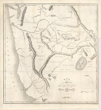
1901-19 [Lot of 4] Clason`s Guide Map of Arizona [and] Territory of Arizona [and] Arizona [and] Arizona. Sketch Map of Irrigated Areas and Main Topographic Features ""A. Clason`s Guide Map of Arizona, by Clason Map Company, dated 1919, printed color (15.0 x 17.6""""). This folding pocket map is complete with descriptive booklet, """"Clason`s Arizona Road Map and Railway Guide"""" (4 x 6.3""""). The map delineates early Automobile Roads and Main Automobile Roads via red overprinted lines. The legend also locates the state capital (Phoenix), counties lines, county seats, railroads, rail trunk lines, Indian reservations, and National Forests. Below the map is a list of towns with populations: Phoenix had just over 30,000 people, a number that stayed small until air conditioning came into commercial use. The map shows Greenlee County, created from part of Graham County in 1909. Folds into paper covers with 24-page booklet which includes full-page city plans of Tucson and Phoenix. Condition: A clean and bright example. (A) B. Territory of Arizona, by General Land Office, dated 1901, printed color (16.9 x 20.2""""). A colorful and fascinating map with great detail issued eleven years before statehood. The extent of nine Indian reservations and at least three Military reservations, including Camp Apache, are clearly shown in different colors. Numerous confirmed and unconfirmed land claims are named and located. A huge Grand Canyon Forest Reserve is shown. The brown hachured mountain area and the blue waterways combine to provide great visual impact. Information includes watershed, mountains, railroads, wagon roads, private claims, unsurveyed townships, etc. A beautiful example published while Harry King was the Chief of Drafting and the Hon. Binger Hermann was commissioner. Condition: Fine. (A+) C. Arizona, by U.S.G.S, circa 1902, black and white (18.4 x 21.7""""). This uncommon map accompanied the 1902 congressional report on preparations for Arizona statehood. It shows the areas that could and could not support population with the vast majority of land deemed """"open to entry, but not capable of supporting population."""" Condition: A clean sheet with one tiny split at a fold intersection and a slightly narrow left margin due to binding trim. (A) D. Arizona. Sketch Map of Irrigated Areas and Main Topographic Features, from Report of Governor of Arizona, dated 1901, black and white (6.4 x 9.0""""). Smaller and more basic map as above, showing the irrigated areas of the state. Condition: Fine. (A+)"" "" W x "" H See descriptions above.

Lot 236

Derby, George Horatio (Lt) 1849 The Sacramento Valley from the American River to Butte CreekÂ… A map of major importance to the California Gold Rush. On a scale of 4-1/2 miles to the inch, it provides a detailed view of the region with numerous small towns, ranches, Diggings (including Mormon and Dry), trails and roads. Interesting notations concern grazing, road conditions and soil fertility. This early look at the Gold Regions locates Sacramento City just south of the American River (as a simple grid pattern), Vernon, Fremont, Sutter and Green Spring. 17.5"" W x 22.5"" H Issued folding with a few very light stains along the folds and a binding trim at left.

Lot 237

Tyson, Philip 1850 Geological Reconnoissances in California This California Gold Rush map shows the area from San Francisco Bay north and east to the Yuba River and east to the Calaveras River. Published in Tyson`s, Report upon the Geology and Topography of California, the map traces his route from San Francisco by way of Vernon to the Yuba diggings, then south passed the Emigrant`s Road to the Salt Lake, through the gold region to the Calaveras River, and west through Bonsal`s Ferry, LivernoreÂ’s Ranch and Martinez. It notes dates of his encampments, geological formations and the points where gold was being mined. According to Wheat, Tyson`s work was ""probably the earliest work of a true scientific research to emerge from the Gold Rush."" 14.8"" W x 11.7"" H Issued folding and trimmed to the neatline at top with some light stains along one fold. There are a few edge chips confined to the left blank margin.

Lot 238

Parke, John G. (Lt.) 1854-55 Map No. 1 From San Francisco Bay to the Plains of Los Angeles... Wheat dedicates more than a full page to what he calls ""a map of the greatest interest, not only for its route, which is that of the Southern Pacific Coast Line, but because of its showing of ranchos and missions along the route."" The proposed line is shown from San Jose south to the Pubela de Los Angeles, San Bernardino and through the San Gorgonio Pass on its way east. Remarkable detail along the route including well rendered hachure depicting elevation. The Spanish Trail, mail route to Salt Lake City and Whipple`s route are shown passing through Cajon Pass and on to the Mojave River. 34.8"" W x 28.2"" H Issued folding, with light toning along a few fold lines. Professionally backed in tissue to support a few separations along folds and a couple of small holes at fold intersections. A binding trim at bottom left, with small loss of neatline, has been re

Lot 239

Vandermaelen, Philippe Marie Guillaume 1825 Amer. Sep. Partie de la Nouvle. Californie. No. 52 ""This map features the central California coast from approximately Monterey south to Catalina Island. A chart of elevations fills the bottom of the map. The Atlas Universel contained 400 maps in six volumes. It was the first atlas made up of lithographed maps, and the first to present all the maps on the same scale (1: 1,641,836), with each map covering an area of approximately 20 degrees longitude (from Paris) and 6 degrees of latitude. If all the maps were joined together they would form a globe of 7.75 meters in diameter. The maps were published by subscription between 1825 and 1827, with each part containing ten maps. There was only one edition and the subscription list shows that 810 copies were sold; thus the maps are quite rare."" 19.6"" W x 18.3"" H Original color with scattered foxing.

Lot 240

U.S. Government, 1847 [Lot of 4] Sketch of the Battle of Los Angeles Upper California... [and] Sketch of the Passage of the Rio San Gabriel... [and] Sketch of the Actions Fought at San Pascal... [and] [Untitled - Map of the California Coast] ""This lot of four government issued maps displays troop positions and actions in Southern California during the Mexican-American war. These maps were published in the Message from the President of the United States to the Two Houses of Congress at the Commencement of the First Session of the Thirtieth Congress in 1847. A. Sketch of the Battle of Los Angeles Upper California, Fought Between the Americans and Mexicans Jany. 9th 1847 (8.4 x 5.8""""). A very early map showing Los Angeles. Locates the Pueblo de Los Angeles, the Rio de Los Angeles, and the moving positions of forces during the battle. B. Sketch of the Passage of the Rio San Gabriel, Upper California, by the Americans, --Discomfiting the Opposing Mex: Forces, Jan: 8th 1847 (8.3 x 6.3""""). Shows the American troops advancing across the Rio San Gabriel and the resulting withdrawal of Mexican forces. C. Sketch of the Actions Fought at San Pascal in Upper California between the Americans and Mexicans Dec. 6th & 7th 1846 (8.0 x 11.2""""). Depicts the battle between Kearny`s troops and those of Mexican Major Andres Pico. Once reinforcements arrived, Kearny was able to push Pico`s troops south and reach San Diego. D. [Untitled - Map of the California Coast] (12.0 x 14.5""""). Covers the California coast from Fort Sacramento south with an inset of lower Baja California. It displays the route of the American militia from Sutter`s Fort to San Diego from mission to mission. There is a key at left that gives the number of men present between different points of the march."" "" W x "" H Issued folding with a few minor spots in the image. The third and fourth map each have binding trims at top, and the third map has one small binding tear closed on verso with archival tape.

Lot 241

1923 [Lot of 5] Los Angeles Times Annual Midwinter Number Parts I-V ""This fascinating lot is a special edition of the Los Angeles Times praising the virtues of Southern California. This """"Midwinter"""" edition, issued on New Year`s Day, ran from 1885 until 1954. It grew in size from a twenty-four page paper in 1886 up to 240 pages composed of five magazines - the maximum size allowable under the postal regulations. The magazines, printed on newspaper, are divided into five parts: Part I - The Year`s Achievements Part II - Commerce, Industry Part III - Encyclopedia Part IV - The Great Southwest Part V - Pictorial Journey (black & white) Part I includes a map of the Southwest United States on the cover and a centerfold entitled """"Los Angeles Harbor"""" which is a bird`s-eye view of the region by Charles H. Owens with an explanation of the points on the map on the preceding page. Part II has a very nice full page illustration of the """"Oil Pools and Wells at Santa Fe Springs."""" Part III has a double-page map by Owens of """"Motor Routes through the Heart of California"""" showing the topography of the state from Sacramento to the Mexican Border. Part IV has a dramatic centerfold map of the Southwest by Owens """"How the Mighty Colorado Will Put to Work for the Whole Southwest,"""" and a full page map of """"Rancho de las Palomas,"""" a massive ranch in Mexico on the U.S. border owner by a Los Angeles family. Part V includes """"The End of the Journey - Los Angeles, Metropolis of the West, Has Room for Expansion,"""" a large, double-page topographical map (black & white) by Owens of the region with an aerial photograph of the center city. In addition to the maps and views listed above, the magazines are absolutely filled with color illustrations and informative content. Folio, complete in five parts, 48 pp. per magazine. A very unique piece for any Southern California collector."" 11.7"" W x 16.4"" H The overall condition is very good considering it is newsprint. The magazines have light to moderate toning with edge tears and chips as to be expected. A few of the pages are loose, and Part V has some dampstaining on the sides and bottom, not signific

Lot 242

1903 Map of the City of Los Angeles ""This great pocket map extends west to the L.A. Country Club at Arlington Street and Wiltshire, east to beyond Evergreen Cemetery and south to Ascot Park. The map extends to the northeast, roughly following Figueroa Street (here named Pasadena Avenue), to Highland Park. Red overprinting radiates from downtown delineating the routes of the Los Angeles Railway, Pacific Electric Railway, Los Angeles Pacific Railway, the Traction Line, and the Los Angeles - Redondo Electric Line. Detailed route information is in a panel at top and right. City street index is at left. Blank verso. Folds into the booklet """"Newman`s Directory Guide and Handbook of Los Angeles and Southern California."""" The 101-page guide of Los Angeles covers everything imaginable """"For Strangers and Residents."""" Plus many unnumbered pages of pictorial advertisements including Morosco`s Burbank Theatre, Hotel Nadeau, Redondo Floral Co., The Automobile Livery and several railroad companies. Beige paper covers, 16mo. Published by T. Newman, 409 Mason Opera House, Los Angeles. The population is listed as only 160,000."" 20"" W x 21.2"" H Map is fine. Text is very good with a few pencil notations in the blank margins.

Lot 243

1925 Engineer`s Preliminary Map of Monterey Peninsula Country Club Subdivisions No. 1 and No. 2 This map shows the preliminary design for the Monterey Peninsula Country Club, which opened in 1926. The layout includes hundreds of homes, the Shore Golf Course, Dune Golf Course, tennis courts, a trapshooting course and an open air theater to name a few of the features. An inset shows the country clubÂ’s footprint on the Monterey Peninsula. Issued by the Del Monte Properties Company. Only 1 copy of a larger version of this map is found on OCLC. 14.6"" W x 13"" H Issued folding with a few small ink notations.

Lot 244

1925-48 [Lot of 3] [Untitled - Map of Avalon Bay] [and] [Untitled - Map of Catalina Island] [and] Avalon Town ""This charming lot contains three promotional brochures of Catalina Island and the town of Avalon including: A. [Untitled Map of Avalon Bay], by Frank E. Brown, dated 1925 (22.0 x 8.3""""). This folding brochure includes a detailed panoramic view of Avalon Bay. Identifies the names of several buildings including Hotel St. Catherine, Catalina Country Club, the estate of William Wrigley Jr., and the training ground of the Chicago Cubs. The verso contains text and illustrations describing the island and its attractions. Brochure measures 9.0 x 4.0"""". Condition: The bottom right corner of the brochure is dog-eared with some very minor soiling along the sheet edges. (B+) B. [Untitled Map of Catalina Island], circa 1927 (13.9 x 6.0""""). Folding brochure containing a pictorial map of the island in the style of Jo Mora or Ruth White. A key at top identifies 24 different points of interest on the island. The verso contains text and illustrations describing the island and its attractions. Brochure measures 9.0 x 4.0"""". Condition: (A) C. Avalon Town, by Wren Lister, dated 1948 (21.6 x 16.5""""). This attractive bird`s-eye view depicts Avalon and the surrounding hills. Vignettes around the border feature the pleasures of the area including water skiing, fishing, sailing, etc. A sticker in the middle of the map image identifies the location of the Sea Breeze Cottages, and a pink paper label with additional advertising for the cottages has been neatly pasted over the central index of the directory. On the verso is an additional map showing all of Catalina. Folds into a mailer measuring 8.5 x 5.5"""". Condition: (A+)"" "" W x "" H See descriptions above.

Lot 245

Hollister, Ovando J. 1867 Map of Colorado Territory to Accompany Hollister`s `Mines of Colorado` Corrected from the Public Surveys of 1866 [with book] Mines of Colorado This scarce map of Colorado shows great detail throughout. The map lists sixteen counties and a large Indian Reserve, which is divided into Cheyenne and Arapahoe tribes. There is extensive watershed information and mountains are shown in hachure. Locates all mining communities, forts, railroads, and more. The map is accompanied by an important book on Colorado: ""The Mines of Colorado."" It provides a view of the geography, geology, climate and agriculture with extensive information on over 165 mining enterprises. 450 pp. Hardbound in quarter leather with tips over marbled paper boards with gilt title on spine. 21"" W x 16"" H The loose folding map is very good with light toning along one fold and a binding trim at right and an associated 2"" binding tear just touching Arapahoe County that has been closed on verso with archival tape. The book is internally very clean and sound

Lot 247

Carey & Lea, 1822 Geographical, Statistical, and Historical Map of the District of Columbia This map of the nation`s capital is on a full folio sheet (20.6 x 16.6"") with surrounding text describing boundaries, climate, population, nearby towns, commerce, government, and history. Washington, Alexandria, and Georgetown are shown as plans, and several waterways and roads are identified. A compass rose capped with a fleur-de-lis indicates that the north is oriented to the upper left and an arrow indicates the direction of the Potomac River. Engraved by Young and Delleker. 10.5"" W x 10.8"" H Original outline color with centerfold separations at top and bottom that do not enter the map image and have been closed on verso with archival tape.

Lot 248

Thomas, Cowperthwait & Co., 1850 City of Washington This finely engraved plan of the Capital names all major streets and buildings; notably, the President`s House, the Smithsonian Institute, and the Navy Yard. The Mall is mostly blank, but the Washington Monument Reservation is present along the Potomac River. Extensive table at lower left lists and keys to map 107 important buildings. Decorative scroll-style border with an engraved vignette depicting the ""Plan of the Principal Floor of the Capitol."" 15.6"" W x 12.5"" H Original color with some light toning along the edges of the sheet.

Lot 249

1861-62 [Lot of 2] Johnson`s Georgetown and the City of Washington The Capital of the United States of America [and] Plan of the City of Washington. The Capitol of the United States of America ""A. Johnson`s Georgetown and the City of Washington The Capital of the United States of America, by Johnson & Browning, circa 1862 (15.1 x 12.3""""). This fine nineteenth century plan of the city also portrays three large vignettes of The Capitol, Washington Monument, and Smithsonian Institution. All major streets and buildings are named. The map is surrounded with a decorative, metalwork border typical of the earlier Johnson maps. Condition: Light toning with a few tiny edge tears. B. Plan of the City of Washington. The Capitol of the United States of America, by S.A. Mitchell, dated 1861 (13.6 x 11.0""""). Nice example of this map with major buildings and sites noted including the Presidents House, Washington Monument and the Smithsonian Institute. Engraved by W.H. Gamble. Surrounded by a floral and ribbon border, which appeared in Mitchell`s atlases from 1863-66. Condition: Just a few tiny spots of foxing and minor soiling in the blank margins."" "" W x "" H See descriptions above.

Lot 251

1784 Cartes Particulieres des Concessions Faites par l`Angleterre a la France et a lÂ’Espagne par la Traite de 1783 ""These four maps represent British possessions that were handed over to Spain and France as a result of the Treaty of Paris. The territories of East and West Florida and Minorca were given to Spain while France gained Tobago and Senegal. The map of Florida is shown with a northern border at 31 degrees latitude, about half a degree farther north than its present border. A huge area along the east coast is shown as swamp, most likely a misplaced Everglades. Each of the maps show only a few place names and basic topography. The map appeared in Nicolas Ponce and Francois Godefroy`s Recueil d`estampes representant les differents evenements de la guerre qui a procure l`independance aux Etats unis de l`Amerique. This was the first French publication to name the United States in its title. On a sheet of French text measuring 8.0 x 9.0""""."" 6.9"" W x 5.1"" H There is a faint damp stain occupying the left portion of the image and an infilled worm track in the bottom left corner of the text beneath the map image.

Lot 252

Hinton, John Howard 1832 Map of the State of Florida The title of this early map is misleading because in 1832 Florida was a territory and not a state. There are only a few counties designated including Monroe County taking in the entire southern tip, and Mosquito County taking in most of the east coast. Seminole Indians are shown in Central Florida and an Indian Path connects a solitary road, that terminates in the Tampa vicinity, with the east coast. A road along the east coast terminates at a town named Florida near present-day Miami. 9.8"" W x 8"" H There are a few small spots of foxing in the image, else very good.

Lot 253

Matthews-Northrup Co, 1926 Map of the Peninsula of Florida and Adjacent Islands. Florida East Coast Railway This 1926 edition is one of the last examples of this map, which first appeared in the 1890s. It shows the Flagler railroad system from Jacksonville to Miami and Key West, with steamboat connections to Havana. Apart from the panhandle, which does not appear on this map, all the current Florida counties are depicted along with cities, roads, rivers and lakes. Includes an inset at bottom ""Map of Florida and the West Indies."" 15.6"" W x 39.8"" H Issued folding with a few fold separations that have been closed on verso with archival tape. There are a few closed edge tears and small damp stains confined to the blank margins.

Lot 254

U.S. Government, 1837 A Plat Exhibiting the State of the Surveys in the Territory of Florida This map is one of the earliest to illustrate the status of public land surveys in the Eastern Land District (east of the Suwanee River) and the Western Land District (west of the Suwanee) in the Florida Panhandle. Survey efforts south of the Indian Boundary Line (marked in red/pink) in southern Florida were largely suspended due to the guerilla warfare of the ongoing Second Seminole War. St. Augustine, Amelia Island, and Tallahassee are named. In this early edition, the supposed boundary of the Forbes Purchase is uncolored and the legend notes that its limits are undefined. From the Surveyors Office in Tallahassee by Robert Butler, Surveyor General for the Territory of Florida. A very early edition of this chart. 23"" W x 8.4"" H Issued folding with a few short fold separations confined to the blank margins that have been closed on verso with archival materials and some minor toning, mostly along the sheet`s edges and folds.

Loading...Loading...
  • 109182 item(s)
    /page

Recently Viewed Lots