

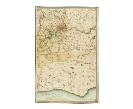
Nolli (Giovanni Battista) Nuova Pianta di Roma, engraved throughout with double-page of note to reader facing title, 4 index leaves numbered 1-4, 12 double-page maps (5-28), 4 more index leaves (29-32) and 2 double-page general maps of modern and ancient Rome by Piranesi and after Bufalini (33-36), the last two loose, the rest mounted on stubs, some light marginal foxing, contemporary ink inscription and note "Dec. 24 1757. Januar. 7.1758 L'ichnographia di Bufalini, e la Topographia di Nolli si trovano nel libro mio di vari Stampe, overo Prints" to front free endpaper, old bookplate, contemporary vellum, spine titled in manuscript, rubbed and rather soiled, [Berlin Kat. 2703, imperfect; Millard Italian 64], folio, [Rome], 1748.⁂ Magnificent plan of Rome with individual sheets to form one large wall map, incorporating vignettes with allegorical figures set against ancient monuments and contemporary landmarks, and a dedication to Pope Benedict XIV surrounded by putti, all within a decorative rococo border. The final two maps by Piranesi and Bufalini are not always found with the main wall map.
We found 109182 price guide item(s) matching your search
There are 109182 lots that match your search criteria. Subscribe now to get instant access to the full price guide service.
Click here to subscribe- List
- Grid
-
109182 item(s)/page
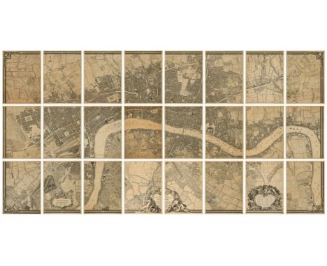
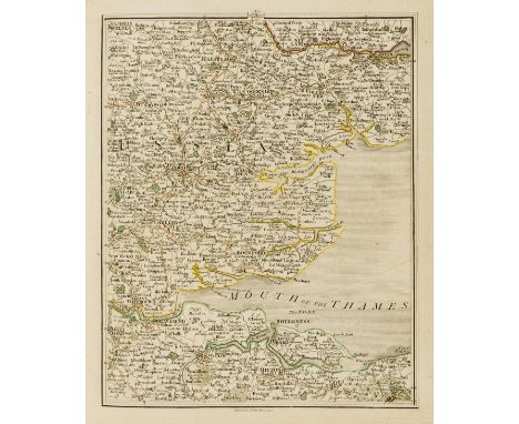
Rocque (John) A Plan of the Cities of London and Westminster and Borough of Southwark, large wall map of London in 24 sheets, extending west to east from Hyde Park to Limehouse and north to south from New River Head to Walworth, an excellent example of the second edition from c.1749 with no changes to the title or imprint, but with some minor alterations to the map, such as the addition of Chesterfield House on sheet A2 (completed in 1749), engravings by Richard Parr on laid paper with large watermarks of Strasbourg Lily and with roman numeral countermarks, each sheet approx. 710 x 515 mm (28 x 20 1/4 in), if joined total map approx. 2130 x 3605 mm (83 3/4 x 142 in), faint horizontal drying creases to some sheets, many corners with small expert repairs to minor loss, other scattered nicks and small tears to marginal extremities with repairs visible verso, some even toning to sheets, but A1 and D2 slightly more browned than the others, larger repaired tears visible verso of H2, upper left corner of C2 with printed map loss replaced in pen facsimile, sheet A1 with repair verso to old splitting to drying crease, otherwise scattered spotting and surface dirt, unframed and loose, presented in modern cloth drop-back box, [Howgego 96 (2)], elephant folio, John Pine & John Tinney, 1746 [but c.1749].⁂ A magnificent and highly detailed 18th century wall map of early Georgian London. Larger than any earlier published map of the city, and a defining moment in the history of London cartography. Begun in March of 1737, upon a scale of 26 inches to one statute mile, the map would take nine years to produce.
![Roussel (French engineer and cartographer, 16[??]-1733) Paris, ses fauxbourgs et ses environs où se trouve le détail des vill](https://cdn.globalauctionplatform.com/7cebb886-88e1-48ab-996d-af1f010038fc/b0ac3cc9-c0bd-4174-a4a4-af1f011994cb/468x382.jpg)
Roussel (French engineer and cartographer, 16[??]-1733) Paris, ses fauxbourgs et ses environs où se trouve le détail des villages, châteaux, grands chemins pavez et autres, des hauteurs, bois, vignes, terres et prez, levez géométriquement, large wall map of Paris extending from Vincennes to the Bois de Boulogne, and from Saint-Denis to Ivry-sur-Seine, decorated with ornate Rococo border featuring cartouche with Royal coat of arms to upper centre, within the map itself numerous famous buildings are depicted including the Palais de Tuileries, the Louvre, the Hotel Royal des Invalides and Notre Dame, among many others, engraving with original hand-colouring, on nine sheets joined and laid on linen with wooden rollers, total size approx. 1250 x 1780 mm (49 1/4 x 70 1/8 in), numerous old tears and small losses, mainly to the extremities, some surface abrasion, surface dirt and browning, handling creases and old folds throughout, rolled, Paris, 1731.⁂ A milestone in the mapping of the city of Paris with particularly fine engraving. Scarce at auction in any edition, but particularly those from the early 1730s; we can find only one other copy in the last 25 years having come to auction.

Speed (John) The Kingdome of Scotland, with inset map of the Orkney Islands, four costumed figures to vertical borders, engraving with hand-colouring, platemark 390 x 515 mm (15 1/2 x 20 1/4 in), sheet 420 x 540 mm (16 1/2 x 21 1/4 in), old repairs verso to central vertical fold, small repairs elsewhere, heavy browning and surface dirt, Bassett & Chiswell, [1676].
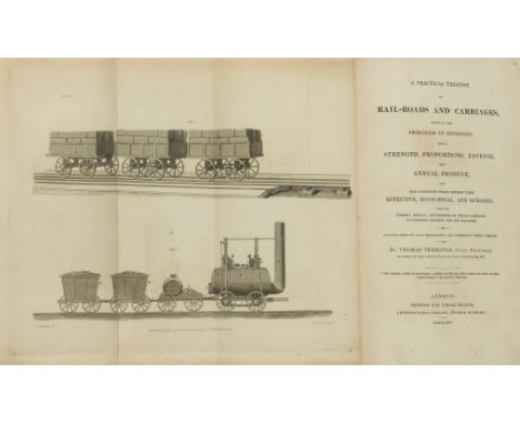
Tredgold (Thomas) A Practical Treatise on Rail-Roads and Carriages, first edition, 16pp. publisher's catalogue at beginning, folding engraved frontispiece, 3 engraved plates, modern half morocco, uncut, 1825; The Principles and Practice and Explanation of the Machinery of Locomotive Engines, Division A only (of 3: B & C being Marine & Stationary Engines), 10 parts in 1 vol., 41 engraved plates on 40 sheets, most folding, one silked, one with small tears to fore-edge, modern half morocco, 1850 § Roscoe (Thomas) The London and Birmingham Railway, folding hand-coloured engraved map dated 1839 bound as frontispiece, additional engraved vignette title and 16 plates, all on india paper and mounted, plan of Birmingham at end, illustrations, tissue guards, foxing to plates, upper hinge split, original cloth, spine gilt, rubbed and faded, Tilt, [1839]; and 7 others on railways including an 1840 Bradshaw's Railway Companion, plate vol. only of Clark's Railway Machinery of 1855 and an oblong folio volume of engravings of bridges, v.s. (10)
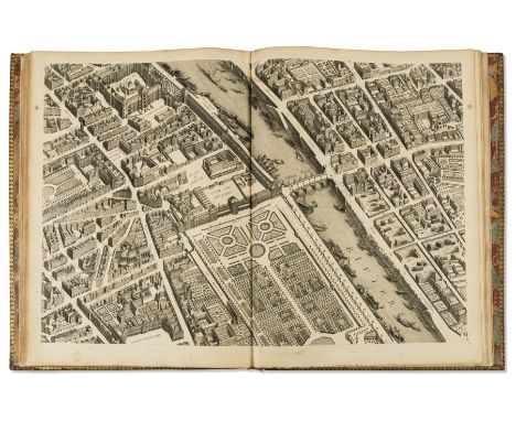
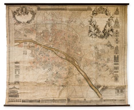
Turgot (Michel Etienne) Plan de Paris, engraved throughout with folding key map and 20 detailed maps by Claude Lucas after Louis Bretez, on thick laid paper, all double-page and mounted on stubs, maps 18 and 19 joined and folding incorporating title in elaborate cartouche (old fold reinforced), some light browning, one or two creases, a few small tears and repairs to lower edge, those in plates 6, 9 & 20 extending into image or border, plate 1 lacking tip at lower outer corner (outside plate-mark), contemporary manuscript note "1740 Ce livre apartieu a Mdelle de Caumigny" to head of front pastedown, also remains of engraved bookplate and wax seal, handsome contemporary French mottled calf with central gilt arms of the city of Paris, gilt fleurs-de-lys and double-fillet border, larger gilt fleur-de-lys corner-pieces, spine gilt in compartments with fleurs-de-lys and red morocco label, rubbed, a few light stains and neat repairs to boards, edges worn, spine ends repaired (worn at foot), [Berlin Kat. 2506; Cohen-de Ricci 807; Millard French 39], folio, Paris, [c.1739].⁂ Turgot's magnificent plan of Paris comprises twenty sheets forming a single bird's-eye plan within a decorative engraved border, measuring approximately 2.5 x 3.2 metres. The extraordinary detail provides a fascinating guide to the city prior to its development by Haussmann in the 19th century.
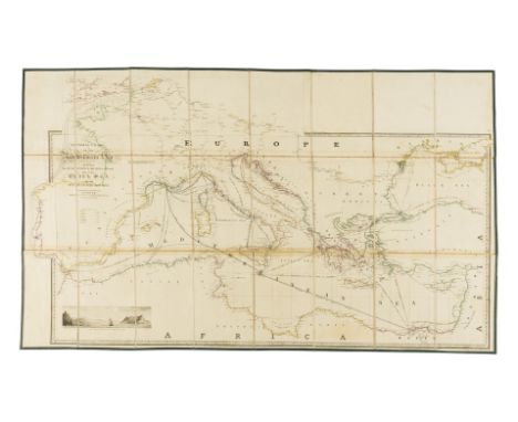
Wyld (James) General Chart of the Mediterranean Sea Including the Gulf of Venice, Archipelago and part of the Black Sea with the Steampacket routes, or 'Wyld's New Map showing the route from London to Alexandria, engraving with original hand-colouring, additional engraved sections pasted collage-style, including the west coast of Spain and the English Channel included above the title, sheet 650 x 1030 mm (25 1/2 x 40 1/2 in), some toning to sheet, scattered spotting and surface dirt, edged with green linen, folding with marbled ends into slipcase with publisher's printed label to upper panel, bumped and worn, 1844; together with 15 further mainly folding maps, including Jean Alibert's 1781 map of Paris 'Nouveau Plan Routier de la Ville et Faubourgs de Paris', three Perrier road maps, 8 various folding maps of the British Isles by Bartholomew and others, Simmon's 1851 'Map of England and Wales showing the Railways, Canals & Inland Navigation Compiled from the Ordnance Surveys and other sources', Stanford's 1863 map 'A new Map of Metropolitan Railways & Miscellaneous Improvements', and a folding strip map of various London rail bridge proposals with stamps of the 'Great Western Railway, Engineers Office, Paddington', various sizes, mainly 19th century (16)
Bradshaw (George) Map of Canals, Navigable Rivers, Rail Roads &c., in the Midland Counties of England; Map of Canals, Situated in the Counties of Lancaster, York, Derby and Chester; Map of Canals, Navigable Rivers, Railways &c., in the Southern Counties of England, 3 large folding maps, the last mentioned presented in 3 sections, engravings with full-hand-colouring, various sizes, some offsetting, minor surface dirt, each trimmed with matching green linen edges, folding with marbled ends into two contemporary morocco uniform book-style slip-cases, rubbed and scuffed, 4to, 1829; included with the maps are two accompanying small books titled 'Lengths and Levels to Bradshaw's Maps' and 'Appendix to G. Bradshaw's Map of the Canals', presented in slipcase with the 'Southern Counties' map, 1829 (2)

Carletti (Niccolo) and Giuseppe Aloja. Mappa Topografica della citta di Napoli et di suoi contorni, 35 double-page engraved sheets incorporating large cartouche with dedication to Charles III of Spain, family tree of coats-of-arms, panorama of Naples and index, all mounted on stubs, some light marginal foxing, small tear to fore-margin of final sheet repaired, later Dampierre bookplate, contemporary half mottled calf, spine ruled in gilt with red morocco label, short split to upper joint, spine ends and corners repaired, rubbed, folio, Naples, 1775.⁂ Magnificent map of Naples commenced in 1750 under the direction of Giovanni Carafa and completed by Giovanni Pignatelli, Prince of Monteroduni.
Cary (John) Cary's New Map of England and Wales with Part of Scotland, engraved title, hand-coloured general map and 79 sheets (numbered 1-81), mostly engraved maps hand-coloured in outline but including dedication, key and scale as part of sheets, no sheets numbered 62 or 80 (?]as issued), bound with list of places, directions and index at end, tear to lower inner corner of dedication and general map affecting borders and corner of map (repaired), a good clean copy, modern half calf, spine ruled in gilt with red & blue labels, very slightly rubbed and faded, 4to, 1794.
Cary (John) Cary's Improved Map of England and Wales with a considerable portion of Scotland, planned upon a scale of two statute miles to one inch, monumental survey map, complete in 65 sections, with calligraphic title, index map sheet, and Explanation key sheet, engravings with bright original hand-colouring, each map section approx. 530 x 650 mm (20 7/8 x 25 1/2 in), dissected and mounted on light-brown coloured linen, some offsetting and occasional spotting and browning throughout, minor surface dirt, each folding with printed label of Parisian publisher 'Ch. Piquet', small red ink collector's stamp 'Bibliothèque St. [?] Grieg' to many, and vellum tab to all, the Index map with heavy toning, presented in five uniform blue-green marbled slip-off cases, each with gilt red label to spine lettered in French, rubbed and worn, 4to, 1832 (5)

Cross (Joseph) Cross's New Plan of London, showing from Canonbury to Camberwell, and from Hyde Park to East India Dock, showing outline of Paddington Station, engraved map with vibrant original hand-colouring, 660 x 1100 mm (26 x 39 1/4 in), dissected and mounted on linen, scattered spotting and browning, minor surface dirt, folding with later blue paper ends, lacking slip-case, [Howgego no. 317, an unrecorded variant state between (8) and (9)], 8vo, 1841; and 3 other folding maps of London, including a good copy of 'Davies's New Map of the British Metropolis', c.1853, with early hand-colouring, Davie's 'Post Office London Directory 1858', William Faden's 'The Country Twenty-Five Miles Round London', 1796 (4)
Delagrive (Abbé Jean, Lazarist priest and official geographer of the City of Paris, 1689-1757) Nouveau plan de Paris et de ses Faubourgs, dressé sur la Méridienne de l'Observatoire et levé géométriquement par M. l'Abbé Delagrive, large wall map of Paris with ornate title cartouche in the top right surmounted by the arms of Paris surrounded by the goddesses Piety and Justice, accompanied by Minerva, Neptune, Mercury and Venus, and with another large cartouche in the upper left corner with dedication to King Louis XV, decorated with his portrait, each of the borders decorated with various vignettes and profiles of monuments, including the Louvre, Invalides, Tuileries, Luxembourg, Sorbonne, Val de Grâce, Notre-Dame, and others, with tables identifying locations within columns to each side, engraved map by Louis Borde and Claude Duflos, on six sheets of thick laid paper joined as one and presented on linen with wooden rollers, total size approx. 1550 x 1880 mm (61 x 74 in), some old tears and splits, a few of the joins starting to lift up, some small perforations and surface abrasion, surface dirt and some browning throughout, numerous handling creases and old folds from being rolled, published chez l'auteur, cloître Saint Benoît, Paris, 1728.⁂ Monumental wall map by the Lazarist priest Delagrive, who was originally born in Krakow, Poland. He devoted himself exclusively to topographic engraving, surveying, and triangulation techniques. His plans of Paris, Versailles, and the surroundings of the city, earned him the position "de géographe de la ville de Paris". The present wall map took two years to complete following direct observation rather than copying of others' work, and was said to be the the first plan of Paris offered to the public for subscription. An engraved facsimile was produced after the map and published in 1880.Rare at auction. We cannot trace another copy being sold in the last 20 years. Other examples are held in the British Library as well as a rather worn copy in the Bibliothèque Nationale de France.

![SCOTLAND & IRELANDBLAEU (WILLEM & JAN) [Le Grand Atlas] Geographie Blaviane, contenant les livres xii. & xiii. de](https://cdn.globalauctionplatform.com/8d78902b-1711-42b6-949d-af2b00cde630/dc1b8608-fcb4-4abc-9748-af2b00cf8f79/468x382.jpg)
SCOTLAND & IRELANDBLAEU (WILLEM & JAN) [Le Grand Atlas] Geographie Blaviane, contenant les livres xii. & xiii. de l'Europe, 2 parts in 1 vol., printed title with wood-engraved device and 54 engraved maps, comprising 48 double-page maps of Scotland (of 49) and 6 maps of Ireland (5 double-page), wanting engraved title and the map of Aberdeen & Banff, some browning and damp-staining at edges (occasionally just touching map edge), a few creases, contemporary boards, worn, rebacked in pigskin, folio (538 x 345mm.), Amsterdam, Jan Blaeu, 1667Footnotes:NotesWide-margined copy of the French edition of Blaeu's atlas of Scotland and Ireland, issued as volume 6 of the Atlas major.This lot is subject to the following lot symbols: •• Zero rated for VAT, no VAT will be added to the Hammer Price or the Buyer's Premium.For further information on this lot please visit Bonhams.com

EDINBURGH HISTORYMAITLAND (WILLIAM) The History of Edinburgh, from its Foundation to the Present Time, folding engraved map, engraved plates, modern cloth with ridged morocco spine, Edinburgh, for the author, 1753--ARNOT (HUGO) The History of Edinburgh, engraved frontispiece, speckled calf with ridged red labelled spine, folding map, Creech of Edinburgh and Murray of London, 1779--GEDDIE (JOHN) The Water of Leith From Source to Sea publisher's cloth, Edinburgh, 1896; and three titles relating to the High Constables of Edinburgh (6)This lot is subject to the following lot symbols: •• Zero rated for VAT, no VAT will be added to the Hammer Price or the Buyer's Premium.For further information on this lot please visit Bonhams.com

ROBSON (GEORGE FENNELL)Scenery of The Grampian Mountains...Representing the Hills from Such Points as Display their Picturesque Features, 41 hand-coloured aquatint plates, one hand-coloured engraved folding map, list of subscribers, contemporary half gilt morocco, folio, Longman, 1819For further information on this lot please visit Bonhams.com
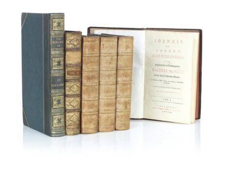
SCOTTISH HISTORYFORDUN (JOHN OF) Scotichronicon, cum Supplementis et Continuatione Walter Boweri, 2 volumes, speckled calf with ridged gilt spine, label ex libris Bibliothecam S.Emerami, folio, Edinburgh 1759--CHALMERS (GEORGE) Caledonia or An Account Historical and Topographic of North Britain..., 3 volumes, speckled half calf with ridged gilt spine, fold-out map in first volume, Caddell and Davies London 1807--GORDON (SIR ROBERT) A Genealogical History of The Earldom of Sutherland From Its origin to the Year 1630, half calf with gilt ridged spine, marbled endpapers, engraved portrait frontispiece, ex libris Alexander Cunighame, folio, Constable Edinburgh 1813--General Post Office Annual Directory 1812-13--Herman Moll's 'Atlas of Scotland' publisher's gilt cloth with calf spine, Limied edtion 147 of 500, with slip case, folio, Heritage Press (5)This lot is subject to the following lot symbols: •• Zero rated for VAT, no VAT will be added to the Hammer Price or the Buyer's Premium.For further information on this lot please visit Bonhams.com


Seven mostly 19th century hand-coloured antiquarian map engravings to include India, bird's-eye view of St. Petersburg, Iceland by Edward Weller, Bohême Silésie Moravie Lusace (18th / 19th century), Turkey in Asia, Australia and Persia. Later glazed gilt frames. Some fading commensurate with age, but mostly in good condition.


A 19th century gilt framed and glazed (later) hand-coloured map engraving by Edward Weller 'The Empire of Japan with part of the continent of Asia showing the river Amoor and the new boundary between the Russian & Chinese Territories' (46.5cm x 31.5cm), together with one other slightly smaller hand-coloured map engraving also of Japan (35cm x 27cm) (2)


* Sampler. A Map of Europe, by Mary Martin, circa 1850, cross-stitch needlework worked mostly in black thread, showing a map of Europe with coloured outlines, above 6 columns, the first and fourth detailing the kingdoms of England, Scotland, Ireland, Norway, Sweden, Denmark, Holland, Belgium, France, Spain, Portugal, Switzerland, Italy, Turkey, Greece, Russia, Prussia, Germany, and Austria, the second and fifth with corresponding chief city for each country, and the third and sixth with the corresponding religion, i.e. 'England - London - Lutherans' and 'Turkey - Constan[tinople] - Mahomedan', 8-line verse to foot flanked by stylised trees in green thread, upper left corner with maker's name, and title enclosed by a double-line octagonal frame, worked on a canvas ground, toned, period darn to top of Africa (4.5 x 2 cm), a few letters missing from verse, 59 x 39 cm (23.25 x 15.5 ins), framed and glazed (68.8 x 49.5 cm)QTY: (1)NOTE:An ususual map sampler with information about the various countries shown, and patriotic verse reading: "Into quarters the Globe we are wont to divide/To live in great Britain in Europe our pride/For Europe though least is now greatest in [l]an[d]/Next America Africa Asia we name/Then America, Africa Asia tis plain/With Europ[e] are quarters our earth doth contain/One Sun and one Moon do enlighten the whole/The Lord made them all and does them control".

Isaak Tirion, Dutch, 1705-1765, Nuova Carta delle Isole di Sunda come Borneo, Sumatra e Java Grande.., published c.1760, Amsterdam, detailed engraved map on laid paper of the region from Sumatra and Malaca, Borneo and Java, 29.5cm x 38cmAttached to card mount with three strips of cellotape to reverse of top edge. Fold to centre and viewed from reverse the two halves have been reinforced with narrow strip of paper. Small tear to left of centre. Some areas of blotchy brown spots to include to left side and lower and centre left, as well as to top right. Some discolouration following centre strip and grey discolouration over words of Borneo Java to lower left. Irregular horizontal crease to centre left. Some slight ruckling to paper. Writing in pencil to lower and top right corner as well as lower left corner of reverse. Small rectangular impression into image in lower margin.

AMENDMENT: Please note, this map now no longer has the glazing of its frame. Robert Laurie & James Whittle, British, 1755-1836 & 1757-1818, Europe divided into its several States according to their Modern Extent, hand-coloured engraved map, published by Laurie & Whittle of 53 Fleet Street, London, May 12th 1794, mounted and held in a gilded glazed frame, 50cm x 57.5cm
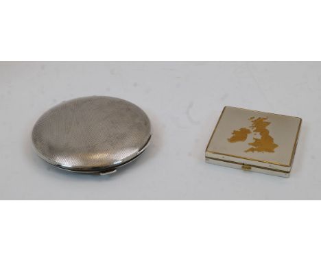
A silver circular engine turned compact, Birmingham, 1932, Goldsmiths & Silversmiths Co. Ltd., gross weight approx. 5.5oz, together with a silver plated compact, gilt edged and with an applied map of Great Britain and Ireland engraved with principle cities, the hinged top enclosing mirrored interior, marked foreign to gilt interior, 1.1cm high, 6.6cm wide, 6.7cm deep (2)Please refer to department for condition report


![Bishop [née Bird], Isabella L. Journeys in Persia and Kurdistan, Including a Summer in the Upper Karun Region and a Visit to](https://cdn.globalauctionplatform.com/c84c49b7-4547-47dd-9e7a-af2c015356cf/c9afaf7a-db37-437d-bb85-af2e011d3495/468x382.jpg)
Bishop [née Bird], Isabella L. Journeys in Persia and Kurdistan, Including a Summer in the Upper Karun Region and a Visit to the Nestorian Rayahs, first edition, in two volumes, London: John Murray, 1891. Octavo, publisher's patterned cloth lettered in gilt, frontispiece to each volume, folding map to rear of each volume, 2pp. publisher's advertisements, all 36 illustrations as called for (13 plates including frontispieces; 23 illustrations within the text; two maps). Contents very good, clean, bright, the occasional mark in places, maps well-preserved with one short tear to blank margin of map in second volume, untrimmed page edges slightly worn & knocked in places, slight wear to gutters at endpapers, cloth bumped & worn at corners/edges with discolouration to lower boards (2)

Africa. A collection of books on Africa to include The Rise of Our East African Empire, by Captain F. D. Lugard, in two volumes, Edinburgh & London: William Blackwood & Sons, 1893, illustrated with plates & maps (some folding), including the map in front pocket, publisher's cloth, bearing armorial bookplate for Robert B. Finlay; In Darkest Africa, by Henry M. Stanley, in two volumes, London: Sampson Low, 1890, ex-library, and others, condition varied, sold with all faults (8)

Alexander, Sir James Edward. An Expedition of Discovery into the Interior of Africa, first edition, in two volumes, London: Henry Colburn, 1838. Octavo, publisher's ribbed blue cloth with gilt lettering & lions to spines, complete with all 15 illustrations as called for (including the folding map and two frontispieces). Vol. I: xxiv, 302pp.; Vol. II: viii, 306pp., 6pp. advertisements. Contents well-preserved, clean, bright, the occasional small mark, one short tear to folding map, neat owner inscriptions, cloth bumped & worn at corners with some loss at spines (2)

Livingstone, David. Missionary Travels and Researches in South Africa, first edition, London: John Murray, 1857. Octavo, publisher's embossed cloth lettered in gilt, complete with all illustrations, plates & maps, as called for. ix, 687pp., 4pp. publisher's advertisements dated 1 November 1857, 8pp. other advertisements. The book includes a quantity of loosely-inserted newspaper clippings, 1869-72, reporting on the disappearance, safety, and death of Livingstone, with one article stating that he has been murdered, and another claiming he 'has been killed and burnt by the natives'. There is also a letter dated 1864 regarding an order of wool, recipient unknown, which has presumably been used as a bookmark with notes referring to the text, and a later inscription on ffep stating that the book was 'rescued from an unoccupied house in Helgoland, via a requisitioned German warship'. Contents generally good, but the text-block detached from its worn cloth binding, the map in rear wallet is very well-preserved, sold as found with all faults

Johns, W. E. Biggles Sweeps the Desert, first edition, October 1942, colour frontis. & eight b&w illustrations (two double-page), restored wrapper; Biggles Fails to Return, first edition, August 1943, colour frontis. & 15 illustrations, map endpapers, dust-jacket with loss at top & bottom of spine; Biggles in the Jungle, first edition, 1944, colour frontis. & four illustrations by Terence Cuneo, dust-jacket chipped at edges, loss at base of spine, cloth faded top & bottom edges; Biggles in the Orient, first edition, November 1944, colour frontis. & 12 illustrations by W. Stead, dust-jacket priced 6/- on flap, pale blue cloth, slightly faded at spine & corners (4)

Johns, W. E. Gimlet Comes Home, first edition, Hodder & Stoughton, 1946, illustrated by W. Stead, unclipped dust-jacket, neat owner inscription. Tog. w/ five Brockhampton first editions comprising: Gimlet's Oriental Quest, 1948, unclipped d.j.; Gimlet Lends a Hand, 1949, clipped d.j.; Gimlet Bores In, 1950, unclipped d.j.; Gimlet Off the Map, 1951, unclipped d.j.; Gimlet Mops Up, first edition, 1947, the final title in worn wrapper with loss & lacking ffep (6)

Sir Stanley Spencer, CBE RA (1891-1959). Stanley Spencer, by Elizabeth Rothenstein, London: Phaidon, 1945, bearing gift inscription from Stanley Spencer to Richard Smart [a director at Arthur Tooth & Sons Gallery], 'Very kind regards to Richard Smart from Stanley Spencer, Dec 28th year of St Anthony (1945)', with a loosely-inserted autograph letter signed by Spencer, inviting Smart to his home at Cliveden View, Cobham Rise, with a sketched map explaining how to find the property, pencil, signed 'Stanley', the book itself bearing Richard Smart's bookplate [by Reynolds Stone] and notes, including 'S.S. with a deal of truth once declared himself "on the side of angels and of dirt"', hardback, no dust-jacket. Together with Stanley Spencer: The Astor Collection, by Carolyn Leder, limited edition numbered 246/950, London: Thomas Gibson, 1976, hardback with dust-jacket, bookplate of Richard Smart; Stanley Spencer RA, Royal Academy of Arts, London: Weidenfeld & Nicolson, 1980, bookplate of Richard Smart; several postcards, prints, clippings and ephemera [not signed by Stanley Spencer], a couple of the postcards addressed to Richard, one from Ronald Shaw-Kennedy, plus a more recent typed letter to Caroline from Jeremy Gardiner

![Landt, Rev. G. A Description of the Feroe [Faroe] Islands with An Account of Their Situation, Climate and Production, London:](https://cdn.globalauctionplatform.com/c84c49b7-4547-47dd-9e7a-af2c015356cf/ac6fad26-13e7-4452-95f9-af2e011cd254/468x382.jpg)
Landt, Rev. G. A Description of the Feroe [Faroe] Islands with An Account of Their Situation, Climate and Production, London: 1810. Octavo, half-calf with marbled boards, re-laid & rebacked. Including folding map and two plates (one folding). Contents worn and discoloured, sold with all faults
![ALOSTUM, URBS FLAN DRIAE IMPERATORIAE FIRMISSIMA [Aalst, a very strong city in Imperial Flanders], a hand coloured engraved m](https://cdn.globalauctionplatform.com/de28c272-998a-48c0-8dc6-af23008b2074/77deae20-9f8b-4fef-bcbf-af25009b58c1/468x382.jpg)
ALOSTUM, URBS FLAN DRIAE IMPERATORIAE FIRMISSIMA [Aalst, a very strong city in Imperial Flanders], a hand coloured engraved map on laid paper, published for the "Civitates Orbis Terrarum" of Georg Braun and Frans Hogenberg circa 1590, soldier vignette top right, title cartouche lower left, visible plate mark, Latin text and "Cities Exhibition" label verso, 33cm x 42cm (sheet 41cm x 54cm) (at fault)

A hand coloured woodcut Ptolemaic map of Central Asia north of the Himalayas, early 16th century, divided into "Scithia Extra Imaum" [Scythia Outside Imaum, home to the nomadic Scythian people] and "Serica Regio" [Silk Region], with a reference to "Antropophagorum" [cannibals] in the north, and "hippophagi" [horse eaters] in the northwest, climate notes down the right hand side, illuminated Latin text verso, probably published for a Lorenz Fries edition of "Geographia" (editions published in 1522, 1525, 1535 and 1541), 42cm x 57cm, unframed CONDITION REPORT:The map side shows bleed-through from the illuminated border and capital of the Latin panel verso, and further stain-through from the reinforcing strip applied verso. There is a repair to the lower right corner of the paper, and soft pencil inscriptions to the top right and bottom right corners. There is a fox mark approximately halfway down the right side of the paper, with further foxing, stain marks and areas of dirt across the paper, but most noticeably to the lower lower left and right corners. The reverse of the paper is in a similar condition.

A collection of unframed British county maps, 17th century and later, to include: after John Speed (1552-1629), SHROPSHYRE DESCRIBED THE SITUATION OF SHROWESBURY SHEWED WITH THE ARMES OF THOS EARLES, AND OTHER MEMORABLE THINGS OBSERVED, a later coloured map on laid paper, title cartouche with the arms of Roger Montgomery and John Talbot, inset map of Shrowesbury [sic], published by George Humbell circa 1625, trimmed to plate mark and strengthened with paper mounting strips, the sheet 40cm x 54cm; with after John Speed, STAFFORD COUNTIE AND TOWNE WITH THE ANCIENT CITIE LICHFIELD DESCRIBED; maps from various editions of "Moule's English Counties"; maps from various editions of "The Beauties Of England And Wales; etc. (Qty) (at fault)
![After John Ogilby (1600-1676), THE CONTINUATION OF THE ROAD FROM LONDON TO HOLYHEAD [plate 3] COMENCING AT THE CITY OF LICHFI](https://cdn.globalauctionplatform.com/de28c272-998a-48c0-8dc6-af23008b2074/f9948696-7a75-48dd-afb0-af25009b6a19/468x382.jpg)
After John Ogilby (1600-1676), THE CONTINUATION OF THE ROAD FROM LONDON TO HOLYHEAD [plate 3] COMENCING AT THE CITY OF LICHFIELD & EXTENDING TO THE CITY OF CHESTER, a strip road map on laid paper, later hand coloured, visible plate mark, 31cm x 43.7cm, framed and glazed; with three further strip road maps on laid paper after John Ogilby, THE ROAD FROM LONDON TO CARLISLE IN COM: CUMBERLAND, 33.5cm x 42cm, framed and glazed; THE ROAD FROM SHREWSBURY AND CHESTER TO HOLYWEL COM FLINT, visible plate mark, 35.5cm x 45.5cm, unframed; and THE CONTINUATION OF YE ROAD FROM LONDON TO ST DAVIDS, visible plate mark, 34cm x 45cm, unframed, pasted to later board (4)
![After Johannes Janssonius [Jan Jansson/Jan Janszoon] (1588-1664), DUCATUS EBORACENSIS ANGLICE YORKSHIRE, an engraved map on p](https://cdn.globalauctionplatform.com/de28c272-998a-48c0-8dc6-af23008b2074/56fcb2e3-1596-4291-bc06-af25009b6bf3/468x382.jpg)
After Johannes Janssonius [Jan Jansson/Jan Janszoon] (1588-1664), DUCATUS EBORACENSIS ANGLICE YORKSHIRE, an engraved map on paper depicting the county of Yorkshire, the title cartouche depicting stonemasons, the scale cartouche depicting farmers and livestock, visible plate mark, later hand coloured, possibly taken from "Le Nouvel Atlas Ou Theatre du Monde : Auquel Est Representée La Grande Bretagne... Amstelodami : apud Joannem Janssonium" published 1646, 39cm x 49.5cm, framed and glazed (at fault)
-
109182 item(s)/page