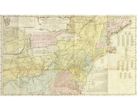

POWNALL (THOMAS)A Topographical Description of Such Parts of North America as are Contained in the (Annexed) Map of the Middle British Colonies in North America, FIRST EDITION, large folding hand-coloured engraved map of the 'Middle British Colonies in North America. First Published by Mr. Lewis Evans, and since corrected and improved, as also extended, with the addition of New England, and bordering parts of Canada; from actual surveys ... by T. Pownall... March 25th 1776' on 2 sheets joined (510 x 845mm.), a few tears at blank gutter margin, light stain in lower margin of title-page, edges untrimmed with some corners rolled, contemporary blue wrappers, lacks spine, upper cover creased at edges with later paper label [ESTC T97733; Howes P543; Sabin 64835], folio (440 x 275mm.), J. Almon, 1776Footnotes:FIRST EDITION OF POWNALL'S IMPORTANT MAP OF AMERICA, complete with the original descriptive text. The map makes revisions to Lewis Evans's map and analysis of 1755, providing new details including New England and bordering parts of Canada, and the addition of the route of Christopher Gist's 1750-1751 trek through Kentucky, West Virginia, and Ohio. As well as Gist's journey, those of explorations by Captain Harry Gordon (1766), Captain Anthony Von Schaik (1756), Captain Humphrey Hobbs (1756), and Lewis Evans (1743) are described in the text.Provenance: Sold on behalf of a descendant of Thomas Pownall.This lot is subject to the following lot symbols: •• Zero rated for VAT, no VAT will be added to the Hammer Price or the Buyer's Premium.For further information on this lot please visit Bonhams.com
We found 109182 price guide item(s) matching your search
There are 109182 lots that match your search criteria. Subscribe now to get instant access to the full price guide service.
Click here to subscribe- List
- Grid
-
109182 item(s)/page
![BIBLIA NEERLANDICA -- DEN BIBEL. Tgeheele Oude ende Nieuvve Testame[n]t met grooter naersticheyt naden Latijnsche[n] text gec](https://cdn.globalauctionplatform.com/e74b066e-c7e3-49f4-87ae-b09600c49d57/dda1196b-0c55-47d9-8bd4-b09600e9c644/468x382.jpg)
BIBLIA NEERLANDICA -- DEN BIBEL. Tgeheele Oude ende Nieuvve Testame[n]t met grooter naersticheyt naden Latijnsche[n] text gecorrigeert. (…) Met schoone[n] Figueren ghedruckt ende naerstelijck weder oversien. Item oock een schoone zeer profitelijcke Tafel (…) niet ghedruct geweest. (Antwerp, W. Vorsterman, 1542). 3 parts in 1 vol. (14), 196; 166; 102 lvs. W. letterpress ti. to O and NT within border consisting of 4 woodcut illustr. (the one for the NT slightly deviant), 1 fold. woodcut map of the Holy Land (270 x 390 mm), a calendar printed in red & black on 3 pp., c. 250 woodcuts of uneven size in text, partly by Jan Swart, num. decorated woodcut initials and ornaments, and printer's device of two-headed eagle on verso of final page. Fol. Later vellum, spine raised in compartments & gilt dec., black ti. label. (Inner margin of some lvs. reinforced, rep. in places, fold. map. rep. on v°, a bit stained/thumbed throughout, tear in leaf e6 (OT), small hole in inner margin leaf C6 (NT), occasional stains/small defects, but a very good copy). NOTE: Rare, complete copy of the 5th edition of the Vorsterman Bible (first 1528), richly illustrated with an abundancy of fine woodcuts, including the map of the Holy Land after Lucas Cranach. The text follows the Liesvelt Bible, was read by protestants and catholics alike and became a large success. One of the rarest 16th c. bibles. - Den Hollander 73; Belgica Typ. 464 &5201; Darlow & Moule 3285; Poortman I, pp. 92-94; Poortman & Augusteijn, Kaarten in bijbels, pp. 63-65.

BIBLIA NEERLANDICA -- LUYKEN, J. Afbeeldingen der merkwaardigste geschiedenissen van het Oude en Nieuwe Testament (…) met nieuwe en leerzame Beschryvingen opgeheldert. Amst., Joh. Covens & Corn. Mortier, 1729. W. 5 engr. double-p. maps (incl. a world map), and 62 double-p. engr. (39 to the OT and 24 to the NT), and 30 additional engr. to NT in text. Fol. Cont. tree cf. bind., spine gilt and raised in compartments. (Upper hinge broken, bind. in general a bit worn, 1 map bound upside down, but in very good condition). NOTE: In fine modern clamshell cardboard box. Second edition of the 1729 publication w. the 30 'oval' engravings at the end of the NT, called for by Poortman II, p. 131.

BIBLIA NEERLANDICA -- (MARTIN, D.). Historie des Ouden en Nieuwen Testaments. (Vert. d. W. Séwel). Amst., P. Mortier, 1700. 2 vols. (18), 282, (8); (26), 163, (11) pp. W. 2 differing engr. fronts., lge. engr. vign. on each ti., 32 engr. head- & tailpieces, 5 engr. double-p. maps (incl. a world map & 3 indexes) & 214 engr. plates (141 to the Old & 73 to the NT) w. c. 428 illustrations. Lge-fol. Cont. full cf. w. raised bands, richly dec. gilt backs, large gilt dec. centerpieces (w. angel) on all sides, surrounded by 2 gilt dec. borders. (Spines a bit dam. espec. at the ends, joints (partly) split, corners bumped/worn, some faint marg. waterstains, else a fine and clean set with ample margins). NOTE: So-called 'Grote bijbel van Mortier'. One of the finest illustrated bibles produced in the Netherlands with engravings after Luyken, Picart, Goeree, Tideman, Hoet by Baptist, Blois, Mulder a.o. On this luxurious bible cf. Van Eeghen/v.d. Kellen 351; Klaversma/Hannema 180, 187; Poortman II, 98-105.

BIBLIA NEERLANDICA -- (MARTIN, D.). Historie des Ouden en Nieuwen Testaments. (Vert. d. W. Séwel). Amst., P. Mortier, 1700. 2 vols. (18), 282, (8); (26), 163, (11) pp. W. 2 differing engr. fronts., lge. engr. vign. on each ti., 32 engr. head- & tailpieces, 5 engr. double-p. maps (incl. a world map) & 214 plates w. c. 428 engr. illustrations. Lge-fol. Richly gilt dec. cont. cf. w. large gilt center pieces on all sides (all a bit dam. unfortunately), spines w. red label raised in compartments. (Binds. a bit rubbed and dry, stamp on first free endpaper repeated on h.-title, but apart from some minor flaws in a very good interior condition). NOTE: So-called 'Grote bijbel van Mortier'. One of the finest illustrated bibles produced in the Netherlands with engravings after Luyken, Picart, Goeree, Tideman, Hoet by Baptist, Blois, Mulder a.o. On this luxurious bible cf. Van Eeghen/v.d. Kellen 351; Klaversma/Hannema 180, 187; Poortman II, 98-105.

BALTIC -- CATTEAU-CALLEVILLE, J.P. Tableau de la Mer Baltique, considerée sous les rapports physiques, géographiques, historiques et commerciaux. Par., Pillet, 1812. 2 vols. xvi, 355, (1); (4), 358, (1) pp. W. large fold. engr. map & 3 fold. tables. Beautifully cont. marbled cf. w. richly dec. spines, dec. gilt borders on both sides, green mor. labels & marbled edges. (Top of spine vol. 1 chipped, else a fine set). NOTE: Kress 5962; Goldsmiths B.20411.
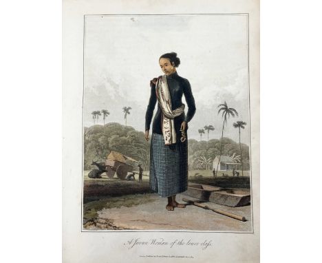
JAVA -- RAFFLES, Th.S. The history of Java. Lond., printed by Cox and Baylis for Black, Parbury and Allen, and for John Murray, 1817. 2 vols. xlviii, 479; viii, 288, (4), cclx (appendix) pp. W. 64 (of 65) engr. plates. by W. Daniell & several fold. tables. Ocl. (Spines discold. & dam. at ends, cloth dam. at extremities, vol. 1 w. faint waterstaining in first chapter, one p. torn through & repaired w. Japan tape, several smaller tears which do not run into text or images, repaired on v°. w. brown paper, some pp. a bit loose but holding, several plates in vol. 2 w. annot. in ink, some yellowing throughout, fold. map of Java lacks). NOTE: First edition, printed in 900 copies only. Abbey Travel 554; Bastin/Brommer 80-90. - Sold w.a.f., not subject to return.

SOUTH AMERICA -- PETIT, P. Traité historique sur les Amazones; Où l'on trouve tout ce que les Auteurs, tant Anciens que Modernes, ont écrit pour ou contre ces Heroines: Et où l'on apporte quantité de Medailles & d'autres Monumens anciens, pour prouver qu'elles ont existé. Leyden, J.A. Langerak, 1718. (8), 324; (2), -325-621 pp. W. engr. front., 1 fold. map, 3 full-p. engr. and 47 small engr. in text. Sm-8°. Cont. vellum. (A bit browned throughout, map misfolded, but a good copy altogether). NOTE: Amazons (Ancient Greek: Amazónes or Amazonides) was the name given by the Greeks to a mythical people of female warriors, who in the epic were situated beyond Troy and also in Thrace. In the 6th century BC they were thought to live in Scythia, in the 5th century BC they were situated in Themiscyra near the Thermodon and in the Hellenistic period they were situated in the far east and west. This is the translation in French of the Latin edition which was published in Amsterdam in 1687. - Brunet IV, 529.

ATLASES -- PEETERS, J. L'Atlas en abrégé, ou Nouvelle Description du Monde, (…). Antwerp, "Chez l'Auteur aux quatre Parties du Monde", 1692. (4), 82, (2) pp. W. engr. front. and 42 plain double-p. engr. maps, incl. a celestial and a world map by Harrewijn. Sm-8°. Later cf. bind. (Margins a bit cropped, some soiling/thumbing, but a very good copy). NOTE: From the library of Raymond Gevers, Antwerp and w. his bookplate. - Koeman Pee 1.

ATLASES -- SCHOTANUS À STERRINGA, B. Uitbeeldinge der Heerlijkheit Friesland. Zoo in 't algemeen als in haare 30 bijzondere Grietenijen. (Leeuw.), Fr. Halma, 1718. (2) lvs. W. fine engr. allegorical front. by Folkema, full-p. engr. coat of arms of Friesland, 2 full-p. dedicatory engr. consisting of coats of arms (i.a. of noble Frisian families), and 39 engr. double-p. maps, of which 2 extra large, all superbly cold. by a cont. hand. Lge-fol. Late 19th c. h. marbled cf. w. simili reptile print covers. NOTE: Second revised and enlarged edition of the first atlas of the Dutch province of Friesland, the pictorial decoration of 22 of the maps being executed by the brothers Jan and Caspar Luyken. All the maps and plates magnificently coloured by hand. With printed table of content laid down on inside front cover, every map also with small printed index label on v°-sides. - Koeman III, Schot2.

ATLASES -- (WEILAND, C.F.). Allgemeiner Hand-Atlas der ganzen Erde nach den besten astronomischen Bestimmungen, neuesten Entdeckungen und kritischen Untersuchungen entworfen. Weimar, Verl. d. Geogr. Instituts, n.d. (1827-33). W. steel-engr. ti.-p., letterpress double-p. index, and 60 steel-engr. double-p. maps by C. Metzeroth, cold. by hand in outlines. Lge-fol. Cont. hcf. bind. w. marbled paper sides. (Bind. worn, more or less foxed/slightly browned throughout, traces of use, outer right margin map of Russia a bit dam. (but without loss of image), lower outer corners of first 10 maps stained). NOTE: This copy still with the title page of the earlier editions; later the title is altered to 'Allgemeiner Handatlas der ganzen Erde und des Himmels'. With all the maps called for: 2 hemisphere maps and maps of Europe (39), Asia (6), Africa (7), America (5) and Australia (1).
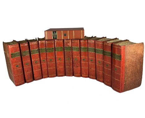
MARITIME HISTORY - TRAVELLING -- COOK, J. Reize rondom de waereld. Vert. d. J.D. Pasteur. Leyden, (etc.), Honkoop, Allart & v. Cleef, 1795-1809. Tog. 14 vols. incl. index by W. Chevallerau & clamshell box. W. engr. portr. of the author, 13 ti.-vign., 52 fold. maps, 134 (fold.) fine engr. views, etc. by A. & J.S. Klauber & C. v. Baersel, (5 lge-fold. maps loose in box). Fine cont. h. red roan w. dec. gilt backs & green labels, uncut & matching clamshell box. (Binds. skilfully restored, A few plates w. glue remnants on v° (show through a bit on r°), but altog. a very nice and complete set). NOTE: The first collected edition in Dutch, probably based on the German ed. of 1781, with a short biography of James Cook added. The first three volumes contain the life of Cook and Cook's first voyage from 1768-1771 after the account by J. Hawkesworth. Vols. 4 -7 contain Cook's second voyage from 1772-1775 after Cook's own account with notes from the Journal by G. Forster, and vols. 8 -13 contain Cook's third and last voyage from 1776-1778, after the accounts by and J. King & himself. This set with the large folding map of the world (nr. 26). - Tiele 268; NHSM 1, 140.

MARITIME HISTORY - TRAVELLING -- HULSIUS, L. Erste -, Siebende -, Neuntzehende -, Zwanzigste Schiffa(h)rt(h). (=Vols. 1, 7, 19, and 20). Frankfurt a/M, (etc.), 1624-29. 4 vols. of the series. W. tog. 4 (of 5) fold. maps, 11 extra full-p. engr. maps (not called for), and tog. 19 (of 33) engr. views. Sm-4°. Mod. hcf. w. marbled paper brds., new endpapers. (Large part of text vol. 7 fails which is also dam., all a bit browned). NOTE: All four volumes incomplete in some way, but with the rare world map in vol. 1 and the map of New England by Smith. - Church (Vol. 2): 260, 287, 311 and 312. - Sold w.a.f., not subject to return.

MARITIME HISTORY - TRAVELLING -- RALEIGH, W. Brevis & admiranda descriptio regni Guianae, auri abundantissimi, in America, seu novo orbe, sublinea aequinoctilia siti: Quod nuper admodum, annis nimirum 1564 [i.e. 1594]. 1595 & 1596. Nuremberg, Imp. L. Hulsii, 1599. (6), 12, (2) pp. W. ti-engr., 6 engr. plates & 1 fold. engr. map (laid down on thin linen mount). 4°. Cont. cf. (Skilfully rebound w. use of old calf, page 2 is misnumb. 6, margins skilfully restored in places, outer margin of some plates cut too short, a bit thumbed/stained in places). NOTE: Sabin 67546: "This Latin translation of Raleigh's account of his voyage to Guiana was probably printed subsequently to the German version of the same year, (…) which forms the fifth part of the series of voyages published by Hulsius. (…) The map and plates are the same as those in the German version. The map represents the northern part only of South America, with the date 1599." The lower part of the map was published in 1602. - Adams R-46 (no map). Provenance: Nicholas Darnell Davis (1846-1915), Colonial Office, Downing Street, dated Dec. 4th 1873.

MILITARY HISTORY -- PFAU, Th.Ph. de. Histoire de la campagne des Prussiens en Hollande en MDCCLXXXVII. Trad. de l'Allemand. Berl., 1790. xii, 40, 310 pp. W. stipple-engr. portr. of the Earl of Brunswick, 1 lge-fold. engr. map & 14 plans, cold. in outlines. 4°. Cont. hcf. w. red label. (Joints split, corners a bit bumped).

HAARLEMMERMEER -- LEEGHWATER, J.A. Haarlemmer-Meer-Boeck. Dienende Tot een Remonstrantie, Verklaring ende Voor-bereydinge om de Haarlemmer ende de Leytse-Meer te bedyken (…). Mitsgaders: Van meest alle de Meeren die in Noort-Hollant tegen de Huigen-dyk en Saardam bedykt (…). 48 pp. W. 1 fold. map & engr. portr. of Leeghwater. - Bound with: Id. Een Kleine Chronyke ende Voorbereidinge v.d. Afkomste ende 't vergroten van de Dorpen van Graft en de Ryp. 47, (1) pp. W. 1 full-page engr. & 2 engr. in the text. - Amst., P. Visser, J. v. Heekeren & J. Graal, 1714. 2 in 1 vol. 4°. Cont. blind tooled vellum. (Sl. browned in places). NOTE: Nijhoff/v. Hattum 181; Haitsma Mulier/v.d. Lem 289; Kemper 392.

HEDENDAAGSCHE HISTORIE, of tegenwoordige staat der Ver. Nederlanden. Dl. 27-29: Tegenwoordige staat van Overyssel. Amst., 1781-1801. 3 vols. (4), 494; (4), 533; (2), 614 pp. W. engr. ti., fold. map & 7 fold. engr. views. (Without vol. 4.1). -- Added: HEDENDAAGSCHE HISTORIE, of tegenwoordige staat der Ver. Nederlanden. Dl. 23-26: Beschrijving van Friesland. Amst., 1785-89. 4 vols. W. engr. front., 3 (of 4) fold. maps, 11 fold. views. -- Tog. 7 vols. Uniformly bound in cont. hcf. w. raised bands and red & blue labels. NOTE: Tiele 1033.

POLDER MAPS -- DELFLAND -- KRUIKIUS, N. & J. 't Hooge Heemraedschap van Delfland met alle de Steden, Dorpen, Ambachten, Litmaten, Polders, (etc.). (N.pl.), 1712-50. Engr. ti. in 2 parts, engr. general map & 25 numb. double-p. engr. maps (each measuring 515 x 590 mm) by T. Doesburgh, L. v. Anse, J. & J. Deur & P. Sluyter after N. & J. Kruikius & A. Houbraken (forming, when put together, a wall map of 260 x 280 cm). Lge-fol. Cont. mottled cf., gilt dec. spine raised in bands, rectangle-shaped gilt centrepiece with title on both front & back, surrounded by 2 gilt dec. borders. (Spine ends slightly dam., endp. on both ends yellowed & somewhat stained, maps in very good condition). NOTE: Several maps flanked by fine large armorial cartouches. "Niet door het formaat, maar door de kwaliteit van de kartografie waarmee op de "gevoelige" schaal van 1:10.000 gewerkt is overtreft de Delfland-kaart alles wat er in de 17e en 18e eeuw in de categorie waterschapskaarten gepresteerd is." Koeman. Geschied. v.d. kartografie van Nederland, p. 140; Donkersloot-de Vrij 806; C. Nonhof 'De meetkundige grondslag v.d. kaart v. Delfland v. 1712 door de gebroeders Kruikius'. In: Caert-thresoor. Jg. 31, nr. 4, 107-114; De Wilt, (a.o.). Delflands kaarten belicht, p. 29.

ITALY -- L'ITALIE PITTORESQUE. 2ème ed. Paris, Ledoux, 1845. C. 600 pp. Prof. illustr. w. many etchings & 1 fold. map. 4°. Ocl. w. gilt dec. & gilt edges. (Dam. to extremities, hinges delicate, some spotting & yellowing). -- Th. ROSCOE. The Tourist in Switzerland and Italy. Lond., 1830. W. many engr. plates. Cont. hcf. extra. & gilt edges. -- C. STRAHLHEIM. Die Wundermappe (…). 1. Bd., III Abt. Unter-Italien (Neapel). Frankfurt a. M., 1834. W. engr. plates. Private hcf. w. dec. edges. (Some dam. to extremities). -- (3).
EGYPT - SUDAN -- VERNER, W. Sketches in the Soudan. Lond., R.H. Porter, 1885. (4), 4, (4) pp., (39) lvs. with one-sided text, lithogr. ti., lithogr. cold. map & 37 tinted lithogr. plates by J.G. Keulemans after Verner, & at the end 2 pp. w. publisher's advertisements. Fol.-obl. Or. h. vellum w. printed front cover. (Bottom of spine torn, sides a bit stained and worn along edges, last 8 lvs. waterstained in upper margin). NOTE: The first edition of this highly successful account of a military expedition in the area, based on the diaries of the author and illustrated with fine lithos after his locally produced drawings.
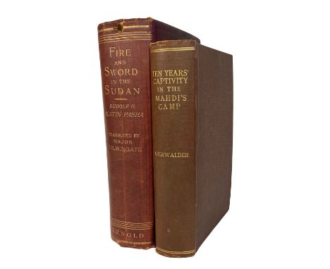
EGYPT - SUDAN -- WINGATE, F.R. Ten years' captivity in the Mahdi's camp 1882-1892. From the original manuscript of Father Joseph Ohrwalder. Lond., 1892. 459 pp. W. many plates & photogr. lithographs in the text, and 3 fold. maps: Plan of Omdurman, Map of the Nile Basin, and Sketch map showing (…) Uganda. Ocl. (Shelfwear, some yellowing & foxing, maps delicate at attachment points). From the library of Arnold Toynbee w. his autograph on first free endpaper. -- R. SLATIN. Fire and sword in the Sudan. A personal narrative of fighting and serving the Dervishes. 1879-1895. Lond., 1896. W. several plates & 2 fold. maps. Ocl. (Wear at extremities, first free endpaper and frontispiece detached, otherwise a clean copy). -- (2).

HARDOUIN, E. & W.L. RITTER. Java. Tooneelen uit het leven, karakterschetsen en kleederdragten van Java's bewoners in afbeeldingen naar de natuur geteekend. Leyden, W. Sijthoff, 1855. xiv, (2), 242 pp. W. mounted lithogr. on engr. ti., fold. map of Java cold. in outlines and 26 handcold. lithogr. plates. 4°. Or. (!) richly gilt dec. cream cloth, a.e.g. (Bind. soiled/stained, extremities sl. worn, a bit browning/foxing). NOTE: Landwehr, Books w. cold. plates, 302; Bastin/Brommer 539.

ASIA -- "2 PARTIE DE LA NOUVELLE GRANDE CARTE DES INDES ORIENTALES, Contenant les Empires de la Chine & du Japon, les Isles Philippines, (etc.)". Amst., J.B. Elwe, 1792. Engr. map in cont. colouring on laid paper w. wm 'Henry Reno'. 537 x 620 mm. NOTE: In very good condition. Koeman El 2 (28).


ASIA -- CHINA -- "IUNNAN IMPERII Sinarum Provincia Decimaquinta". (Amst., J. Blaeu, 1658-59). Engr. map w. large dec. cartouche w. elephants & infants, & legend with a Buddha statue. Cont. handcold. 450 x 500 mm (image size). (Some smudges at the margins, margin reinforced w. paper in one place, colours clean & bright). -- "XENSI, IMPERII Sinarum Provincia Tertia". (Amst., J. Blaeu, c. 1655-59). Engr. map w. dec. cartouche & legend w. a donkey (?), cont. handcold. 400 x 485 mm (image size). (Some smudges at the edge of the margins, small tears of c. 2 cm at upper and lower end of the fold, colours crisp). -- "IMPERII SINARUM nova descriptio". (Amst., J. Blaeu, c. 1655-59). Engr. map w. dec. cartouche. Cont. handcold. 480 x 650 mm (image size). (Yellowed, some waterstains, small tear at the fold, upper end of the fold reinforced w. tape). -- And 1 o. (4). NOTE: Van der Krogt II, 8435:2; 8423:2; 8410:2B.

ASIA -- INDIA -- "MAGNI MOGOLIS IMPERIUM". Amst., P. Schenk & G. Valk, (c. 1700). Engr. map in cont. handcolouring w. 2 cartouches 365 x 485 mm. NOTE: An attractive map in good condition of the region bounded by Northern India, Pakistan, Afghanistan and Bangladesh and extending inland up the Ganges and Indus Rivers to Tartary and the Himalayas, including Katmandu, Kabul and other legendary cities along the great trading route. - Koeman III p. 114 (nr. 421).

ASIA -- INDIA -- "PENINSULA INDIAE citra Gangem, hoc est, Orae celeberrimae Malabar & Coromandel cum adjacente Insula non minus celebratissima Ceylon". Nürnb., Homann heirs, 1733. Cont. handcold. engr. map, large dec. cartouche w. elephant in lower right corner. 537 x 475 mm. (Sm. tear in outer blank margin, else a fine copy of this attractive map). -- Added: "LES INDES ORIENTALES". Venice, 1779. Engr. map cold. in outlines by S. Robert. 490 x 575 mm. -- (2).

ASIA -- "INSULARUM MOLUCCARUM nova descriptio". Amst., J. Janssonius, (1633). Engr. handcold. map. 380 x 500 mm. French text on v°. (Remargined). -- Added: "NATOLIA, quae olim Asia Minor". (Amst., Blaeu, 1635). Engr. plain map. 385 x 495 mm. Latin text on v°. -- And 1 o. (3). NOTE: Van der Krogt I, 8560:1; II, 8110:2.


ASIA -- SRI LANKA/CEYLON -- "INS. CEILAN quæ incolis Tenarisin dicitur". (Amst., Mercator-Hondius, 1623). 347 x 500 mm. Engr. map in cont. colouring w. 3 cartouches and compass card. (Strengthened on fold on v°, 2 small marg. rep., sl. browned). NOTE: Latin text on v°. - V.d. Krogt I, 8380:1A:1.

ASIA -- "TARTARIAE SIVE MAGNI CHAMI REGNI". (Amst., J. & G. Blaeu, c. 1640). Engr. plain map w. cartouche w. camel. 385 x 500 mm. (Sm. tear/rep. on bottom of fold, else fine). NOTE: Blaeu's famous map of the region from the Caspian Sea to the East China Sea, with the Great Wall clearly marked. German text on v°. - V.d. Krogt II, 8050:2.

ATLANTIC -- "PASCAERTE vande Zee custen van Guinea, en Brasilia; Van Cabo de Verde, tot C. de bona Esperança: en van R. de Amazones tot Rio de la Plata, (…)". Amst., J. v. Keulen, n.d. (c. 1700). Engr. chart in cont. colouring. 600 x 510 mm. (Some very minor foxing, 5 small rep. to marginal splits on v°, but in fine condition). NOTE: Map of the South Atlantic Ocean, showing the coasts of Brazil and western Africa, oriented to the North. From Van Keulen's 'Zee-fakkel', part V. - Cf. i.a. Koeman IV, p. 357.

BELGIUM -- "LEODIENSIS DIOECESIS TYPUS". (Antw., Ortelius, 1603). Engr. plain map. 379 x 497 mm. (Sm. rep. on v° fold., sl. yellowed). -- NOBILIS HANNONIAE COMITATUS DESCRIP.". (Antw., Ortelius, 1603). Engr. plain map. 370 x 495 mm. -- "BRABANTIÆ, Germaniæ inferioris nobilissimæ provinciæ descriptio". (Antw., Ortelius, 1584). Engr. handcold. map. 365 x 504 mm. (Remnants of hinges, browned). -- And 1 o. (4). NOTE: Van den Broecke 63 (1603L40), 70 (1603L43), 65, (1584L34), 44 (1574L15).

BELGIUM -- "SECUNDA PARS BRABANTIAE cuius urbs primaria Bruxellae". (Amst.), G. & J. Blaeu, (c. 1640). Engr. handcold. map. 415 x 525 mm. (Remnants of hinges in upper margin). -- "PARS FLANDRIAE TEUTONICAE OCCIDENTALIOR". (Amst.), G. & J. Blaeu, (c. 1640). Engr. plain map. 380 x 490 mm. -- "FLANDRIAE PARTES DUAE". (Amst.), G. & J. Blaeu, (c. 1645). Engr. handcold. map. 415 x 525 mm. (Remnants of hinges in upper margin, sl. yellowed). -- Added: "BELGII PARS MERIDIONALIS cum Occidentalibus Germaniae et Septentrionalibus Franciae Confiniis". (Amst., N. Visscher, c. 1680). Engr. handcold. map w. 'Table alphabetique/Naamwyser on v°. 475 x 535 mm. (Sm. marg. rep., Arabic writing in upper margin, marg. stains). -- (4). NOTE: Ad 1-3: French text on v°. Van der Krogt 3111:2, 3201:2, 3215:2.

EASTERN EUROPE -- "BOHEMIA". (Amst., G. & J. Blaeu, c. 1645). Engr. plain map. 410 x 545 mm. (Sl. yellowed). -- "SILESIAE TYPUS descriptus et editus a Martino Heilwig Neisense, et nobili viro Nicolao Rhedinger dedicatus anno 1561". (Antw., Ortelius, 1592). Engr. plain map. 279 x 384 mm. -- And 1 o (browned/laid down) map of Moravia (Mercator). (3). NOTE: Ad 1: Latin text on v°. - Van der Krogt II, 2850:2; Latin text on v°. - Van den Broecke 102.

EASTERN EUROPE -- "HUNGARY REGNUM". Amst., G. & J. Blaeu, (1635). Engr. plain map. 420 x 510 mm. (Fold rep. on v°). -- "HUNGARY REGNUM". (Amst.), H. Hondius, (1638). Engr. plain map. 370 x 445 mm. (Stain in lower blank margin, a bit browned). -- "SCLAVONIA, CROATIA, BOSNIA cum Dalmatiæ parte". (Amst., Mercator/Hondius, 1638). Engr. plain map. 360 x 460 mm. -- "KARSTIA, CARNIOLA et Windorum marchia cum confinys". (Amst., Mercator/Hondius, 1638). Engr. plain map. 345 x 475 mm. (Stain in lower blank margin, sl. browned/foxed). -- (4). NOTE: Latin text on v°. Van der Krogt II, 2800:2A; Latin text on v°. Van der Krogt I, 2800:1A.2; Latin text on v°. Van der Krogt I, 7601:1.2; Latin text on v°. Van der Krogt I, 7170:1A.2.

EASTERN EUROPE -- POLAND -- "CARTE DES ETATS DE LA COURONNE DE POLOGNE, nouvellement dessinée par Tob. Mayer / Mappa Geographica Regni Poloniæ (…)". Nuremberg, Heirs of Homann, 1750. Engr. map, modestly cold. by hand, w. large armorial cartouche in left lower corner. 495 x 560 mm. (Some splits in blank margin (1 rather deep and closed at v°-side), but in good condition). -- Added: "LUBOMERIÆ et Gallicæ Regni". (Nuremberg), Heirs of Homann, 1775. Engr. map, partly cold. by hand, w. large armorial cartouche in upper right corner. 472 x 605 mm. -- (2).

EASTERN EUROPE -- POLAND -- "DER KÖNIGLICHEN REPUBLIK POLEN, Woiwodschaft, Kiow, das ist die obere Polnische Ukraine oder Klein Polens östlicher Theil" - "DER KÖNIGLICHEN REPUBLIK POLEN, Woiwodschaften, Plotzk und Masau oder Gross Polens östlicher Theil" - (Vienna, 1791). 2 engr. maps by I. Albrecht, cold. in outlines. 260 x 320 mm each. -- Added: "Li PALATINATI di Cracowia, Lekzyca, Sieradz, Sandomir, e Lublino, tratta dall' Atlante Polacco del Sigr Rizzi Zanoni". Venice, A. Zatta, 1791. Engr. map, cold. (in outlines) by hand. 328 x 420 mm. -- And 3 o. of Poland. (6).
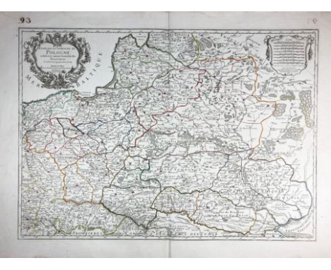
EASTERN EUROPE -- POLAND -- "ESTATS DE LA COURONNE DE POLOGNE Subdivisés suivant l'estendue des Palatinats". (Par.), N. Sanson, 1708. Engr. map by H. Jaillot, cold. in outlines, with title cartouche and scale of miles in second cartouche. 470 x 650 mm. (In v.g. condition, but upper outer left corner torn off (corner however present and provisionally fixed again on v°)).

EASTERN EUROPE -- POLAND -- "LES PALATINATS de Plock, De Brzesc, d'Inowroclaw, de Culm, de Posnanie et le Nouveau Palatinat de Gniezno formé de la partie septentrionale de celui de Kalisz / Woie wodztwa Pomorskie y Malborskie oraz Pomerania Elektorska". N.pl., no publ., n.d. (18th c.). Plain engr. map of the North of Poland, engr. captions in upper and lower margin. 670 x 580 mm. (Folds visible, browning to vertical fold on the left side, 3 splits in right outer margin). - Very detailed map.


EASTERN EUROPE -- POLAND -- "POLONIA ET SILESIA". (Amst., Mercator/Hondius, 1634). Plain engr. map. Dutch text on v°. 350 x 462 mm. (Some small splits and dents in upper blank margin, tiny wormholes in lower blank margin). V.d. Krogt I, 1900:1A.1. -- Added: "POLONIA REGNUM, et Silesia Ducatus". (Frankf.), M. Merian, (1638). Engr. map, w. some modest colouring. 280 x 363 mm. -- And: "POLONIÆ finitimarumque locorum descriptio Auctore Wenceslao Godreccio Polono". (Cologne), Joh. Bussemecher, (1594). Plain engr. map. 186 x 266 mm. -- And 2 o. of Poland (Moll and De Fer). (5).


EASTERN EUROPE -- POLAND -- "ROYAUME DE POLOGNE par Robert de Vaugondy. Divisé et corrigé Selon les partages faits en 1815, entre la Russie, la Prusse et l'Autriche". N.d., c. 1815. Engr. map cold. in outlines. 255 x 295 mm. -- "NIEUWE KAART van t' Koninkryk Poolen verdeelt in zijn byzondere Waywoodschappen". Amst., I. Tirion, c. 1760. Plain engr. map. 300 x 360 mm. -- "DELINEATIO geometrica arcis et civitatis Marienburgensis in Borussia obsessæ (…) anno 1656" - "DELINEATIO geometrica civitatis Elbingesnsis (…)" - "DELINEATIO FORTALITIJ POLONORUM (…)" - (1697). 3 engr. plans both from Pufendorf's chronicle on The Northern Wars and military campaigns of Sweden's King Charles X. -- And 8 o. relating to Poland, incl. 3 small maps. (13).

EASTERN EUROPE -- POLAND -- "SCHLESIA nach aller gelegenheit in Stetten, Wässern und Bergen, mit sampt andern anstossenden Ländern". (Basel, c. 1590). Woodcut map from Seb. Munster's 'Cosmographia' of the Silesia region of Poland. 305 x 362 mm. (Margins short, but in fine condition, German text on v°).

EASTERN EUROPE -- ROMANIA/MOLDAVIA -- "PRINCIPATUS TRANSILVANIÆ in suas quasque nationes (…)". Nuremberg, J.B. Homann, (c. 1720). Cont. handcold. engr. map w. cartouche. 495 x 583 mm. (Lower blank corners a bit stained). -- "TRANSYLVANIA SIBENBURGEN". (Amst., G. & J. Blaeu, 1635). Engr. plain map. 382 x 500 mm. (Sl. browned on fold). -- "PONTUS EUXINUS sive Mare Nigrum vulgo Das Schwarze Meer". (Nuremberg), Homann Heirs, 1769. Cont. handcold. engr. map. 473 x 512 mm. (A few faint marg. stains). -- (3). NOTE: Ad 2: Latin text on v°. - Van der Krogt II, 7700:2.


EASTERN EUROPE -- RUSSIA -- "NOVISSIMA RUSSIÆ TABULA". (Amst.?, H. Hondius, 1638). Engr. plain map by I. Massa. 472 x 555 mm. (Sm. chip/crack in lower margin, sl. yellowed). NOTE: Decorative example of the Mercator-Hondius map of the Russian Empire and Scandinavia. Latin text on v°. - Van der Krogt I, 1800:1B.1.


EUROPAM SIVE CELTICAM veterem. (Amst., Janssonius, c. 1638). 355 x 475 mm. -- Added: "PLAN DE LA VILLE de la Gibaltar". Amst., N. Visscher, 1706. Engr. plain map of the Gibraltar peninsula with a plan of Ceuta and an elevation view of the Rock of Gibraltar. 440 x 530 mm. (Margins cut, sl. yellowed). -- And: Map of Great Britain by Blair. -- (3). NOTE: Ad 1: Latin text on v°. Van der Krogt 1000H:1A.

FORTIFICATIONS - SIEGES -- SERVIA -- "NIEUWE ACCURATE CAART van de omleggende Lande van Belgrado, als mede des selfs Belegeringh, ende Marse der Keyserlyke Armee A° 1717". Amst., J. Ottens, (c. 1720). Engr. map of the siege of Belgrade and surroundings in cont. colouring above 1 engr. containing 3 perspective views of "Peter Wardein", "Belgrad" and "Temeswar", also cold. Map 350 x 420, views 100 x 420 mm. In fine condition.


FRANCE -- PARIS -- "PLAN DE LA VILLE et Faubourg de Paris divisé en 12 municipalités". Par., Jean, 1797. Engr. map cold. in outlines w. cartouche, divided in 24 sections, mounted on linen. Total size: 638 x 976 mm. In or. gilt tooled slipcase with green title-label: "Nouveau plan de Paris'. (Slipcase a bit dam., a few faint stains). NOTE: An extraordinary map of pre-Haussmann Paris and the early Faubourgs (suburbs) issued in 1797, during the final days of the Directory and the French Revolution and just two years before rise of Napoleon Bonaparte. Covers Paris on both sides of the Seine from the Champ de Mars to Le Trone, extends north as far as Montmartre and south roughly to Port Royal.

FRANCE -- "PERFECTE KAERTE, van t' Berger en Broucborger Ambacht, mitsgaders de wateringen ende de vier dycken". (Amst.), J.C. Visscher, 1658. Engr. handcold. map on 2 joined sheets w. inset plans of Duynckercken, Brouckborgh and Mardijck. 408 x 748 mm. (Sev. sm. marg. repairs, a bit browned in places). -- And 1 o. (browned) map. (2).

GERMANY -- "CIRCULI SAXONIÆ SUPERIORIS" (&) "CIRCULUS SAXONIÆ INFERIORIS". (Amst.), F. de Wit, (c. 1680). 2 engr. handcold. maps. Each c. 500 x 580 mm. (Second mentioned, w. some rep. on v°, remnants of hinges, lower blank corners cut, sl. foxing). -- "NOVA TOTIUS WESTPHALIA descriptio". (Amst.), F. de Wit, (c. 1680). Engr. handcold. map. 475 x 545 mm. (Sl. browned). -- "THÉATRE DE LA GUERRE ou carte nouvelle du cours du Rhin". Amst., R. & J. Ottens, (c. 1740). Engr. handcold. map. 505 x 595 mm. -- "KORT BEGRYP VAN DUYTSLAND, de drie ryx collegien (…)". Utr., C. Specht, 1706. Engr. handcold. table w. inset map of Germany, 15 coats of arms w. description, 42 sm. coats of arms and an extensive explanation of the hierarchy and the functions of the noble families mentioned. 508 x 595 mm. -- (5).

GERMANY -- ORTELIUS -- "BRANDENBURGENSIS Marchae Descriptio". (Antw., 1592). Engr. plain map. 359 x 501 mm. -- "BAVARIAE olim vindelicae (…)". (Antw., 1592). Engr. plain map. 383 x 490 mm. -- "WIRTENBERG DUCATUS". (Antw., 1592). Engr. plain map. 384 x 440 mm. -- "WESTPHALIAE TOTIUS, (…)". (Antw., 1592). Engr. plain map. 346 x 498 mm. -- "SAXONIAE, MISNIAE, THURINGIAE, (…)". (Antw., 1592). Engr. plain map. 345 x 503 mm. -- "GERMANIAE VETERIS TYPUS". (Antw., 1592). Engr. plain map. 363 x 459 mm. -- (6). (A bit browned/foxed in places). NOTE: Van den Broecke 97, 110, 113, 91, 93, 199.

GERMANY/BALTIC -- "NOVA FAMIGERABILIS INSULAE ac ducatus Rugiae descriptio". (Amst., J. Hondius/Mercator, 1619). Engr. handcold. map. by E. Lübben w. large cartouches. 375 x 485 mm. (Lower margin rep., browned/foxed). -- "LIVONIA VULGO LYEFLAND". (Amst., G. & J. Blaeu, 1642). Engr. handcold. map. 380 x 500 mm. (A bit browned/foxed). -- "POMERANIAE DUCATUS TABULA". Amst., G. Blaeu, (c. 1640). Engr. plain map. 380 x 485 mm. (Sl. foxed/browned). -- Added: 1 (rather dam.) map of Denmark. -- (4). NOTE: French text on v°. Van der Krogt I, 2192:1A; German text on v°. Van der Krogt II, 1710:2; Latin text on v°. Van der Krogt II, 2190:2.2.
-
109182 item(s)/page