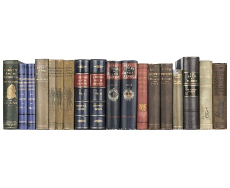
Koldewey (Karl). The German Arctic Expedition of 1869-70, and narrative of the wreck of the "Hansa" in the ice, London: Sampson Low, Marston, Low, & Searle, 1874, chromolithographic frontispiece, 2 maps (1 folding), 3 chromolithograph plates, numerous woodcut illustrations (both full-page and to text), library stamp to title, lightly spotted, endpapers and pastedowns renewed, original green pictorial cloth, rebacked with original backstrip laid on, boards lightly marked, extremities worn, 8vo, together with:Payer (Julius). New Lands within the Arctic Circle, 2 volumes, London: Macmillan, 1876, frontispieces, 2 double-page maps, numerous illustrations (many full-page), half-titles, errata leaf to verso of map in volume 1, bookseller's ticket to rear pastedown of volume 2, lightly spotted, original blue pictorial cloth, rebacked, boards lightly dust-soiled, extremities worn, 8vo, withGreeley (Adolphus). Three Years of Antarctic Service, an account of the Lady Franklin Bay Expedition of 1881-84, 1st edition, 2 volumes, New York: Charles Scribner's and Sons, 1886, frontispieces, large folding map in rear pocket of volume 2, 4 further maps (1 folding), numerous woodcut illustrations (full-page and to text), hinges cracked, upper margins of titles torn with loss (touching text), original pictorial dark blue cloth, extremities rubbed, boards faintly marked, 8vo, with 13 other books related to Polar explorationQty: (18)


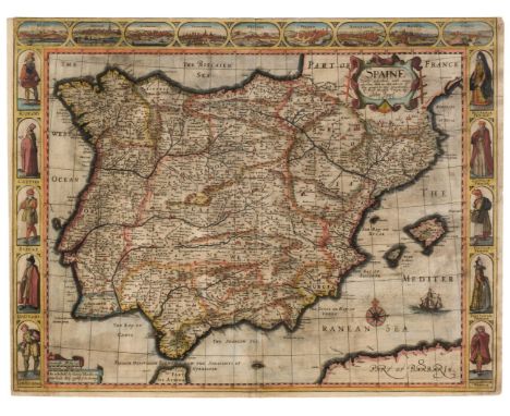
![Scotland. Ortelius (Abraham), Scotiae Tabula, [1573 or later], engraved map with contemporary hand-colouring, orientated to t](https://cdn.globalauctionplatform.com/bdb07c26-397e-4c2f-bdb4-ae5c00ef4cbe/53bd6384-df48-4da7-93ea-ae6000e99eaa/468x382.jpg)


![Bible [English]. The Holy Bible, containing the Old Testament, and the New: Newly translated out of the original tongues: and](https://cdn.globalauctionplatform.com/bdb07c26-397e-4c2f-bdb4-ae5c00ef4cbe/103182ce-6412-4ab5-b4fa-ae6000e895b5/468x382.jpg)
![[Mearne Binding for Charles II]. The Works of Publius Virgilius Maro. Translated, Adorn'd with Sculpture, and Illustrated wit](https://cdn.globalauctionplatform.com/bdb07c26-397e-4c2f-bdb4-ae5c00ef4cbe/0e9b26ca-26b4-4796-b2ac-ae6000e899c6/468x382.jpg)


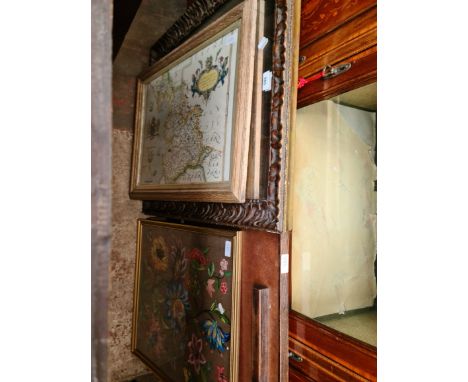
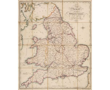
![Embroidered map. Oval map of England & Wales by Eu.[nice Denton] Birch (1777-1877), 1784, map of England and Wales divide](https://cdn.globalauctionplatform.com/bdb07c26-397e-4c2f-bdb4-ae5c00ef4cbe/2503697d-5af9-49b7-97f7-ae6000e8fb49/468x382.jpg)
![Pogany (Willy, illustrator). Rubaiyat of Omar Khayyam, Presented by Willy Poga?ny, London: George G. Harrap & Co., [1909]](https://cdn.globalauctionplatform.com/bdb07c26-397e-4c2f-bdb4-ae5c00ef4cbe/0e46aa42-7d06-4b0d-980b-ae6000e922ae/468x382.jpg)


![Bristol. Braun (Georg & Hogenberg Frans), Brightstowe, [1581], uncoloured engraved city plan, very slight spotting and so](https://cdn.globalauctionplatform.com/bdb07c26-397e-4c2f-bdb4-ae5c00ef4cbe/e413b476-83b8-4765-8456-ae6000e95a79/468x382.jpg)