We found 109198 price guide item(s) matching your search
There are 109198 lots that match your search criteria. Subscribe now to get instant access to the full price guide service.
Click here to subscribe- List
- Grid
-
109198 item(s)/page


Lot 59
Cary (John). Cary's New and Correct English Atlas: Being a New set of County Maps from Actual Surveys..., 1793, engraved title, twelve pages of road junctions and two pages of an index to routes, general map of England & Wales, and forty-six (complete) engraved maps with contemporary outline colouring and some later enhancement to the titles and the coastline, each with a page of descriptive text, some near contemporary manuscript annotations to text pages, map of Nottingham with small repaired hole, occasional spotting and staining throughout, mostly confined to margins, two small indentation marks to upper margin of first thirty-five pages, slight offsetting, bookplate of Count Le Pelletier, contemporary green grained sheep with gilt title to upper siding, spine faded with slight fraying at head & foot, 4to (Qty: 1)NOTESChubb CCLXI

Lot 33
Lyon (George Francis). The Private Journal of Captain G. F. Lyon of H.M.S. Hecla, during the Recent Voyage of Discovery under Captain Parry, 1st edition, London: John Murray, 1824, bound with: ibid., A Brief Narrative of an Unsuccessful Attempt to reach Repulse Bay ... in His Majesty's Ship Griper in the Year MDCCCXXIV, 1st edition, London: John Murray, 1825, 2 works in 1 volume, each with folding map and 7 engraved plates, spotting, later half calf, 8vo (20.8 x 12.4 cm), together with: Scott (Robert Falcon), The Voyage of the 'Discovery', 2 volumes, 1st edition, 2nd imprssion, London: Smith, Elder, & Co., 1905, all plates and maps as called for, spotting, volume 1 inner hinges cracked, plate facing p. 190 loose, volume 2 slightly shaken, original cloth, spine-ends nicked, extremities rubbed, 8vo, Geikie (Archibald, & others), National Antarctic Expedition 1901-1904. Album of Photographs and Sketches with a Portfolio of Panoramic Views, 1st edition, London: Royal Society, 1908, 138 photogravure, halftone or lithographic plates (of 165: lacking plates 23, 107, and 110 and the porfolio containing plates 129-152 and maps A and B), plates 1, 22 and 164 loose, plate 1 damp-stained, contemporary cloth, spine sunned and worn, folio, and 6 others, polar exploration (Qty: 11)
Lot 490
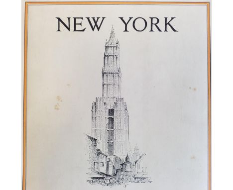
Fleming (Ethel) . New York, 1st edition, 1929, A. & C. Black, 24 monochrome plates plus black & white illustrations by Herbert S. Kates, some light spotting throughout, original illustrated black cloth in dust jacket, covers lightly spotted, large 4to, together with Urwick (W.) , Indian Pictures drawn with pen and pencil, circa 1891, slight spotting throughout, numerous black & white engraved illustrations, all edges gilt, original gilt decorated red cloth, boards & spine slightly rubbed, large 8vo, and Willoughby (Howard) , Australian Pictures drawn with pen and pencil, 1886, colour folding map, numerous black & white illustrations some light spotting, period inscription to front endpaper, original gilt decorated brown cloth, boards & spin light rubbed, large 8vo, plus other late 19th & 20th century travel reference & related, some leather bindings, mostly original cloth, some in dust jackets, G/VG, 8vo/folio (Qty: 6 shelves)
![* Italy. Speed (John), Italia newly augmented by J. Speede, Thomas Bassett & Richard Chiswell, [1676], hand coloured engr](https://cdn.globalauctionplatform.com/45651768-0840-4e6b-a25a-ab4401107d4e/7a3483d5-a497-48ca-8ec6-ab450106e503/468x382.jpg)
Lot 124
* Italy. Speed (John), Italia newly augmented by J. Speede, Thomas Bassett & Richard Chiswell, [1676], hand coloured engraved 'carte à figure' map. decorated with eight costumed figures in the vertical margins and six oval vignettes of the principal cities to the upper horizontal margin, 395 x 520 mm, mounted, framed and double glazed, English text on verso (Qty: 1)
![South West England. Gloucestershire. Saxton (Christopher & Hole G), Glocestriae comitatus olim sedes Dobunorum, [1637], h](https://cdn.globalauctionplatform.com/45651768-0840-4e6b-a25a-ab4401107d4e/70322d97-49e7-4bdc-b62b-ab45010719df/468x382.jpg)
Lot 172
South West England. Gloucestershire. Saxton (Christopher & Hole G), Glocestriae comitatus olim sedes Dobunorum, [1637], hand coloured engraved map, large ornate cartouche, mileage scale and compass rose, toned overall, occasional marginal closed tears, 285 x 315 mm, together with Saxton (Christopher & Kip William). Dorcestriae comitatus vulgo Dorset..., circa 1610, hand coloured engraved map, large strapwork cartouche, mileage scale and compass rose, small margins, laid on later card, 275 x 385 mm, with another six county and road maps of Dorset, Cornwall, Somerset and Gloucestershire, including examples by Conder/Hogg, Owen & Bowen, Badeslade & Toms, De La Rochette and Archer, various sizes and condition (Qty: 8)
![* World. Moithey ( Maurille Antoine), Indication Nautique des Principaux Espaces de l'Ocean, Paris, [1787], hand coloured eng](https://cdn.globalauctionplatform.com/45651768-0840-4e6b-a25a-ab4401107d4e/f7ca3048-7d5a-4cde-9513-ab45010724c2/468x382.jpg)
![Composite Atlas. [Untitled European atlas], mid-late 18th century, German manuscript index, no title or preliminaries, a comp](https://cdn.globalauctionplatform.com/45651768-0840-4e6b-a25a-ab4401107d4e/401bf84b-0125-4bd4-acbd-ab450106d298/468x382.jpg)
Lot 102
Composite Atlas. [Untitled European atlas], mid-late 18th century, German manuscript index, no title or preliminaries, a composite atlas of 86 maps of European countries and regions with maps by Lotter, Seutter, Schenk, Homann and Homann's heirs and De L'Isle, all with contemporary hand and outline colouring with the exception of a map of Spain by Schenk which is uncoloured, the atlas has 3 world maps, 2 on a hemispheral projection by Lotter and Homann's heirs and a Mercator projection by Lotter, a general map of Europe by Lotter and four maps of the British Isles, England & Wales, Scotland and Ireland also by Lotter, a few maps partially split along central fold, a few maps with light toning, occasional spotting and dust soiling, contemporary manuscript title and number to verso of each map, loosely inserted is a four leaf manuscript document in German, the pagination and the index would indicate that two maps have been excised (numbers 4 & 5), contemporary sheep, with a partial index list in blind of eight European countries to upper siding, contrasting morocco title label to spine which reads 'Catalogus Mapparum Geographicarum Tomus I', heavily worn, rubbed and frayed, folio (Qty: 1)NOTESSold as a collection of maps, not subject to return.
Lot 111
England & Wales. A collection of eight maps, 18th & 19th century, including Reilly (Franz Johann). Das Konigreich Englang Nach Kitchin neu verzeichnet herausgegeben, published Vienna, 1795, engraved map with contemporary outline colouring, slight dust soiling, 540 x 695 mm, together with Ellis (J., engraver). Bowles's New One-sheet Map of England & Wales with the addition of New Roads and other Improvements by Daniel Paterson Esq., published Bowles & Carver, [1798], engraved map with contemporary hand colouring, 610 x 530 mm, with Enouy (J.). The Invasions of England and Ireland with all their Civil Wars since the Conquest, published Laurie & Whittle, 1797 [paper watermarked 1810], engraved map with contemporary hand colouring, central fold partially split at base, 435 x 580 mm, plus Paterson (D.). Bowles's New Pocket Map of England and Wales Revised and Corrected from the best authorities, printed for Carington Bowles, 1773, engraved map with contemporary outline colouring, dust soiled, light overall toning, slight staining, some marginal repaired closed tears, 605 x 530 mm, with another four maps similar by De Vaugondy, Gall & Inglis, Johnson & Ward and Sayer, various sizes and condition (Qty: 8)
![South-East England. Blome (Richard), A Mapp of Surrey with its Hundreds..., [1673], hand coloured engraved map, 260 x 310 mm,](https://cdn.globalauctionplatform.com/45651768-0840-4e6b-a25a-ab4401107d4e/666cf913-e9ca-4b1b-955f-ab4501071a50/468x382.jpg)
Lot 173
South-East England. Blome (Richard), A Mapp of Surrey with its Hundreds..., [1673], hand coloured engraved map, 260 x 310 mm, together with A Mapp of the County of Middlesex with its Hundreds, [1681], hand coloured engraved map, old folds, strengthened and repaired on verso, 145 x 210 mm, mounted, with Perrot (A. M.), Middlesex, [1824], engraved map with contemporary outline colouring, 110 x 75 mm, with another eight county, strip road maps and regional maps of South East England by Archer, Kitchin, Paterson, Mogg and Bartholomew, plus an uncoloured engraved view of London, Southwark and Blackfriars bridges By E. Roberts after W. H. Bartlett, plus six county maps of Buckinghamshire and Bedfordshire with examples by Van Langre n , Ramble, Perrot, Seller/Grose, Rollos and Fullarton, and Speed (John). Buckingham both Shyre and Shire towne describ., published Henry Overton, circa 1710, hand coloured engraved map, inset town plans of Buckingham and Reading, trimmed with thread margins, heavily toned overall, 380 x 505 mm, no text on verso (Qty: 18)
Lot 13
Chardin (John). The Travels of Sir John Chardin into Persia and the East-Indies... To which is added the Coronation of this present King of Persia, Solyman the Third, 2 parts in one, 1st edition, London: Moses Pitt, 1686, engraved portrait frontispiece by D. Loggan (dated 1643, repairs to verso), additional engraved title, folding map, 16 engraved plates, one or two leaves detaching, a few tears and small repairs, some mainly marginal damp stains and soiling, a few small marginal wormtracks, some insect damage to fore margins of later endpapers, later calf with red and black labels (one label rubbed), a few stains, small wormtrack to lower cover, folio (Qty: 1)NOTESCox I, pp. 249-50; ESTC R12885; Wing C2043. First English edition, published concurrently with the French edition. Shah Abbas II (and his successor son Suleiman I) had made Chardin his agent for the purchase of jewels in 1666, and the book describes his travels to Persia via India and Russia from 1664-69 and 1671-77 and his account is a highly regarded and reliable source of information on the court, art, religion and culture of Safavid Persia.

Lot 32
Landon (Perceval). Lhasa, an Account of the Country and People of Central TIbet and of the Progress of the Mission sent there by the English Government in the Year 1903-4, 2 volumes, 1st edition, London: Hurst and Blackett, Ltd., 1905, 42 plates including frontispieces (photogravure, halftone and coloured), 3 maps (1 folding), occasional spotting, volume 2 frontispiece loosening, original cloth, spines faded, covers mottled, 8vo, together with: Verner (Willoughby), My Life among the Wild Birds in Spain, 1st edition, London: John Bale, Sons & Danielsson, Ltd., 1909, all plates as called for, including one folding on linen, original cloth, 4to, Ward (F. Kingdon), The Mystery Rivers of Tibet, 1st edition, London: Seeley Services & Co. Limited, 1923, 16 halftone plates, folding map (repaired), original cloth (repaired tear to spine), 8vo, and 15 others, travel including Himalayan exploration and other works by Ward, early 20th century, original cloth (Qty: 21)

Lot 121
Hampshire. Bill (John), Hant Shire , 1626, hand coloured engraved map, 90 x 120 mm, English text on the verso, together with another four county and strip road maps relating to Hampshire, including examples by Cole & Roper, Mogg and Archer, with Illustrated London news, publisher). The City of Salisbury, 1872, uncoloured double page wood engraved view of Salisbury, 360 x 520 mm (Qty: 6)
![* England & Wales. Ortelius (Abraham), Angliae Regni florentissimi nova descriptio auctore Humfredo Lhuyd..., [1602], han](https://cdn.globalauctionplatform.com/45651768-0840-4e6b-a25a-ab4401107d4e/cfdd08aa-08ee-4304-865a-ab450106dd0c/468x382.jpg)
Lot 113
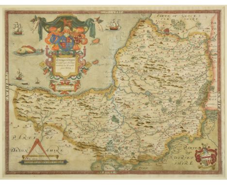
* England & Wales. Ortelius (Abraham), Angliae Regni florentissimi nova descriptio auctore Humfredo Lhuyd..., [1602], hand coloured engraved map, large strapwork cartouche and mileage scale, several repaired marginal closed tears, some staining caused by old tape repair, central fold strengthened on verso, some creasing, 375 x 470 mm, mounted, framed and double glazed (Qty: 1)NOTESMarcel van den Broecke, Ortelius Atlas Maps, 19.
Lot 6
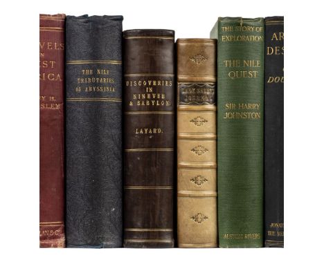
Baker (Sir Samuel W.). The Nile Tributaries of Abyssinia, and the Sword Hunters of the Hamran Arabs, 1st edition, London: Macmillan and Co., 1867, engraved frontispiece, 2 maps (1 folding), 23 wood-engraved plates, light finger-soiling, frontispiece and title-page slightly spotted and marked, short split to one fold of folding map, inner hinges cracked, contemporary patterned cloth, 8vo (22.2 x 14 cm), together with: Sale (Lady Florentia), A Journal of the Disasters in Affghanistan, 1841-2, 1st edition, London: John Murray, 1843, advertisement slip tipped to title-page, plan, folding map (laid down), 12 pp. advertisements, contemporary ownership inscription to title-page, modern half calf to style, 8vo in 12s (19.8 x 12 cm), Layard (Austen H.), Discoveries in the Ruins of Nineveh and Babyon; with Travels in Armenia, Kurdistan and the Desert, 1st edition, London: John Murray, 1853, 14 lithographic plates including frontispiece, 2 folding maps, half-title discarded, repair to plan facing p. 67, plate at p. 115 partly split, closed handling tears to maps, later half calf, 8vo (20.7 x 12.8 cm), and 6 others, 19th and early-20th-century travel, including Livingstone, Missionary Travels and Researches in South Africa, 1st edition, 1857 (Qty: 9)NOTESCzech Africa p. 15 (Baker).
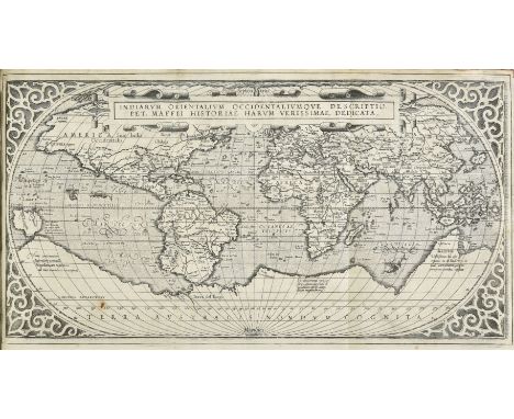
Lot 34
Maffei (Giovanni Pietro). Historiarum Indicarum libri XVI. Selectarum item, ex India Epistolarum, eodem interprete, libri IV. Accessit Ignatii Loiolae vita. Omnia ab Auctore recognita, & nunc primum in Germania excusa, Cologne: In Officina Birckmannica, sumptibus Arnoldi Mylii, 1589, title with printer's woodcut device, early inscription to upper blank margin and square paper patch to lower blank margin obscuring ink stamp, folding uncoloured engraved world map 'Indiarum Orientalium Occidentaliumque Descriptio, Pet. Maffei Historiae Harum Verissimae, Dedicata' (platemark 260 x 485 mm), with small rust spot, a few decorative woodcut initials, initial two leaves loosening, occasional light toning and minor dampstains, 20th-century bookplate of Dr. E. Vandenbergh to front pastedown (possibly later paper), without front free endpaper, contemporary vellum, manuscript title to spine (torn and with some loss at foot), slight wear to lower joint, lacking ties, folio (30 x 18.7 cm) (Qty: 1)NOTESAdams M92; Cordier Sinica 782; Sabin 43770 (note); Shirley The Mapping of the World , 166; cf. Borba de Moraes p. 9 (first edition, Florence, 1588). First edition printed in Germany. Maffei's history of the East and West Indies provides much important information on India, China, Japan and Brazil. 'Later issues are recorded from Venice, Bergamo and Antwerp but only those from Cologne in 1589 and 1593 contain a world map' (Shirley).

Lot 130
London. Mogg (Edward), London in Miniature with the Surrounding Villages, An entire new plan..., 1821, engraved map with contemporary outline colouring, slight staining, 515 x 940 mm, contained in a contemporary marbled card slipcase with printed label to upper cover, case heavily worn and frayed, label with large ink ownership initials (Qty: 1)NOTESJ. Howgego, Printed Maps of London , 237. Unrecorded publication date between states 13 & 14.

Lot 97
British Isles. Munster (Sebastian) , Engellandt mit dem anstossenden Reich Schottlandt so vor Zeiten Albion und Britannia haben geheissen, Basel, [1588 or later], hand coloured woodcut map, orientated to the west, very heavily wormed, repaired on verso, some tape staining largely confined to margins, occasional marginal closed tears, published in the 'Cosmographia' by Sebastian Petri, 320 x 360 mm, German text on verso (Qty: 1)NOTESR.W.Shirley. Early Printed Maps of the British Isles, 1477 - 1650, 148.

Lot 175
* Turkish Empire. Speed (John), The Turkish Empire newly augmented by John Speed, Thomas Bassett & Richard Chiswell, [1676], hand coloured 'carte-a-figure' map, 10 costumed figures to the vertical margins, 8 oval vignettes of the principal cities to upper horizontal border, 390 x 510 mm, mounted, framed and double glazed, English text to verso (Qty: 1)
![England & Wales. Speed (John), The Kingdome of England, 1st edition, John Sudbury & George Humble, [1611], hand colou](https://cdn.globalauctionplatform.com/45651768-0840-4e6b-a25a-ab4401107d4e/5c97102b-76de-4e8b-959c-ab450106dd7c/468x382.jpg)
Lot 114
England & Wales. Speed (John), The Kingdome of England, 1st edition, John Sudbury & George Humble, [1611], hand coloured engraved 'carte-a-figures' map with eight costumed figures to the vertical margins, slight mount staining, central fold partially strengthened on verso, 390 x 520 mm (Qty: 1)

Lot 94
British Isles. A collection of eight maps, 18th & 19th century, including Delamarche (Charles F., Kitchin Thomas & De Vaugondy Robert), Carte des Isles Britaniques qui renferment les Royaumes D'Angleterre, D'Ecosse & D'Irlande..., Paris 1804, engraved map with contemporary outline colouring, inset map of the Shetland and Orkney Islands, descriptive text in column in left hand margin, some spotting and staining, 545 x 720 mm, together with Wells (William). A New Map of the Brittish Isles Shewing their Present Genl. Divisions, Cities and such other Towns or Places as answer to the Towns of note in the time of the Romans, circa 1700, hand coloured engraved map, some creasing, 380 x 500 mm, with De Vaugondy (Robert). Britannicae Insulae in quibus Albion seu Britannia Major, et Invernia seu Britannia Minor..., Paris, 1750, hand coloured engraved map, slight spotting and offsetting, 490 x 545 mm, plus Rossi (Giacomo Giovanni). L'Isole Britanniche overo L'Inghilterra..., 1677, engraved map with contemporary outline colouring, inset map of the Shetland and Faroe Islands, slight staining to margins, 410 x 520 mm, with another four maps similar, including examples by Andriveau, De Vaugondy, Tavernier and Buy de Mornas, various sizes and condition (Qty: 8)
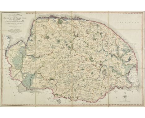
Lot 117
Folding County Maps. Milne (Thomas), A Topographical Map of the County of Norfolk reduced by a scale of Two Statute Miles to one Inch from the Large map in six sheets..., published W. Faden, 1803, engraved map with contemporary outline colouring, sectionalised and laid on linen, 590 x 890 mm, contained in a contemporary marbled card slipcase with publisher's printed label to upper cover, case worn and frayed, together with Dix (Thomas). A New Map of the County of Gloucestershire, Divided into Hundreds, published W. Darton, 1830, uncoloured engraved map, sectionalised and laid on linen, circular cartouche, mileage scale, compass rose and vignette of Tewkesbury Church, slight staining, 455 x 365 mm, contained in a contemporary marbled card slipcase with publisher's printed title label to upper cover case worn and frayed, with Cary (John). A New Map of Cornwall Divided into Hundreds exhibiting its Roads, Rivers, Parks &c., 1828, engraved map with bright contemporary outline colouring, sectionalised and laid on linen, oval cartouche, inset map of the Scilly Isles, 485 x 550 mm, marbled endpapers, contained in a contemporary marbled card slipcase with printed title label to upper cover, plus Hall (Sidney). Berkshire [and] Oxfordshire, circa 1850, two engraved maps with contemporary outline colouring, sectionalised and laid on linen, each approximately 195 x 250 mm, contemporary cloth gilt boards, and Walker (J. & C.). Kent [and] Wiltshire, 1835 & 1846 respectively, two engraved maps with contemporary outline colouring, sectionalised and laid on linen, map of Kent stained and dust soiled, each approximately 400 x 330 mm, bound in contemporary cloth boards with printed label to upper cover, with two folding fox hunting maps of Oxfordshire and South West England, various sizes and condition (Qty: 9)
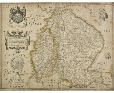
Lot 128
Lincolnshire & Nottinghamshire. Saxton (Christopher & Webb William), Lincolne & Notinghamshire with theire Severall Hundreds and Wapontakes most exactly drawne and described, 1642, engraved map with contemporary outline colouring, light overall toning and slight staining, margins a little frayed, central fold crudely strengthened on verso, 410 x 530 mm (Qty: 1)NOTESA rare edition of Saxton's map of Lincolnshire and Nottinghamshire, published during the English Civil War by William Webb in 'All The Shires Of England'.
![England and Wales. Hole (William), Englalond Anglia Anglosaxonum Heptarchia, [1637], hand coloured engraved map, large strapw](https://cdn.globalauctionplatform.com/45651768-0840-4e6b-a25a-ab4401107d4e/4c146c46-a76a-47d5-9470-ab450106de1b/468x382.jpg)
Lot 115
England and Wales. Hole (William), Englalond Anglia Anglosaxonum Heptarchia, [1637], hand coloured engraved map, large strapwork cartouche and compass rose, 275 x 320 mm, mounted, framed and glazed, together with Danckerts (Theodoris). Novissima et Accuratissima totius Angliae Scotiae et Hiberniae..., Amsterdam, circa 1685, engraved map with contemporary outline colouring, large allegorical cartouche, toned overall, some marginal chipping and staining, paper somewhat brittle, 505 x 585 mm, with another eight maps of England & Wales and the British Isles, including examples by Zatta, Wyld, J & C Walker, Blair, Smith, Archer and Badeslade & Toms, various sizes and condition (Qty: 10)

Lot 56
Atkyns (Sir Robert). The Ancient and Present State of Glocestershire , 2nd edition, 1768, 8 engraved armorial plates, double-page county map, plan and prospect of Gloucester and a view of Gloucester Cathedral, 61 (complete) double page birds-eye prospects of country seats by J. Kip, additional engraved plate of the chapel at Sudeley Castle dated 1782, tipped in to page 369, slight spotting and toning throughout, later marbled endpapers with slight staining, near contemporary half calf gilt rubbed and worn, upper board and front endpaper detached, worn and frayed, folio (Qty: 1)

Lot 57
Bowles (Carington). Bowles's Pocket Atlas of the Counties of South Britain or England and Wales..., printed and sold Carington Bowles, [1785], double page calligraphic title set in an oval cartouche, 56 (of 57) engraved maps on 48 sheets, all with contemporary outline colouring, including 15 folding, lacking index leaf and map of England & Wales, near contemporary manuscript map title to verso of each map, map of Dorset with repaired margins, slight marginal staining, rebacked but retaining contemporary marbled boards, worn and rubbed, 8vo (Qty: 1)NOTESChubb CCLVI. Scarce.

Lot 100
Canada. Blaeu (Johannes), Extrema Americae versus Boream ubi Terra Nova, Nova Francia Adjacentiaq, Amsterdam, circa 1660, engraved map with contemporary hand colouring, slight creasing, some fraying to margins but not affecting image, 450 x 570 mm, Dutch text to verso (Qty: 1)NOTESShowing Newfoundland, Nova Scotia, Labrador and Eastern Canada. This is the only map of Canada produced by Blaeu.

Lot 481
Firminger (Walter Kelly) . The Fifth Report from the Select Committee of the House of Commons on the affairs of the East India Company, 3 volumes, reprinted 1969, New York, publishers uniform original red cloth, 8vo, together with Prashad (Baini) , The Ma?thir-ul-Umar?, 2 volumes, reprinted 2003, The Asiatic Society, Kolkata, some minor marks, uniform original cloth in dust jackets, covers lightly rubbed to head & foot, 8vo, and Fitzclarence (George Augustus Frederick) , Journal of a Route across India, through Egypt to England..., 1999, New Delhi, black & white folding map, colour & monochrome illustrations, original cloth in dust jacket, spine faded & lightly rubbed to head & foot, 4to, plus other modern & scholarly India history & related reference, including publications by Oxford, Cresset Press, Cambridge, H.M.S.O., mostly original cloth in dust jackets, some paperbacks, G/VG, 8vo/4to (Qty: 6 shelves & a carton)

Lot 91
Blaeu (Johannes). Vectis Insula Anglice The Isle of Wight, Huntingdonenensis comitatus Huntington Shire, Radnoria comitatus Radnor Shire [and] Insulae Albion et Hibernia cum minoribus adjacentibus, Amsterdam, circa 1663, together four engraved maps of the Isle of Wight, Radnorshire, Huntingdonshire and a Ptolemaic map of the British Isles, all with contemporary outline colouring, very slight text show-through, each approximately 385 x 510 mm, Spanish text on verso (Qty: 4)
Lot 38
Moseley (Henry Nottidge). Notes by a Naturalist on the "Challenger," ... made during the Voyage of H.M.S. "Challenger" round the World, in the Years 1872-1876, 1st edition, London: Macmillan and Co., 1879, 2 tinted lithographic plates, folding map, occasional light spotting, original cloth, slightly marked, spine strengthened, 8vo, together with: Palgrave (William Gifford), Ulysses, or Scenes and Studies in Many Lands, 1st edition, London: Macmillan and Co., 1887, ownership inscription and light spotting to half-title, bookplate, original cloth, slightly rubbed, faint remnant of label to front board, 8vo, Baker (Sir Samuel W.), The Albert N'yanza, Great Basin of the Nile, and Exploration of the Nile Sources, 2 volumes, 2nd edition, London: Macmillan and Co., 1867, 13 plates including frontispieces, 2 maps (1 folding), occasional light spotting, mild damp-staining towards rear of volume 1, occasional pencil markings and annotations, folding map with discreet repair, volume 1 inner hinges tender, original cloth, slightly rubbed, small hole to volume 1 spine, 8vo, Barrow (Sir John), An Auto-Biographical Memoir, 1st edition, London: John Murray, 1847, frontispiece (spotted), 16 pp. advertisements, endpapers renewed, bookplate (Sir John Ogilvy, Bart, of Inverquaharity), original cloth, spine faded, tips bumped, 8vo, and 10 others, 19th-century travel, original cloth (Qty: 16)NOTESCzech Africa p. 15 (Baker); Mendelssohn I pp. 89-90 (Barrow).
Lot 36
Morgan (Henry J.) . Bibliotheca Canadensis: or a manual of Canadian literature, 1867, Ottawa, period inscription by the author to front endpaper, some light toning throughout, all edges gilt, contemporary gilt decorated full calf, front board loose to foot of spine, boards & spine rubbed & marked, 8vo, together with: Silveira de Braganza (Ronald Louis & Oakes, Charlotte) , The Hill Collection of Pacific Voyages, 1st edition, 1974, University of California, San Diego, monochrome frontispiece & map endpapers, publishers original gilt decorated blue cloth, 8vo, Ferguson (John Alexander) , Bibliography of Australia, 4 volumes, facsimile edition, 1975, Canberra, uniform original cloth in dust jackets, spines slightly faded, covers slightly rubbed to head & foot, 8vo, and other modern Australia, Pacific, & miscellaneous travel bibliography & reference, mostly original cloth, some in dust jackets, 8vo/4to (Qty: 27)

Lot 125
Kent. Symonson (Philip), A New Description of Kent ... the tractes of Ryuers, Rylles and creeks, with the trendinge of the sea-shore be more naturally described then heretofore it hath ben done, printed and sold by Peter Stent 1659, hand-coloured engraved map on two conjoined sheets, inset views of Rye and Dover Castle, ornate strapwork cartouche, old folds strengthened and repaired on verso, several small holes and closed tears affecting image, repaired on verso, trimmed with thread margins, borders extended with later paper, some creasing, 530 x 780 mm (Qty: 1)
Lot 144
Oxfordshire. Plot (Robert), The Map of Oxfordshire..., circa 1677, hand coloured engraved map, decorative cartouche, mileage scale, compass rose and table of explanation, old folds, a few folds repaired on verso, 500 x 480 mm (Qty: 1)NOTESCreated by the first keeper of the Ashmolean Museum of Oxford and decorated with 172 coats of arms of the county's gentry, Oxford colleges, the city and the four county towns. One of the most decorative maps of Oxfordshire ever produced.

Lot 60
Cary (John). Cary's New Map of England and Wales with part of Scotland on which are carefully laid down all the Direct and Principal Cross Roads, the Course of the Rivers and Navigable Canals..., 1st edition, 1794, printed title and dedication, title page with contemporary manuscript signature (Charles Imhoff), general map of England & Wales with contemporary hand colouring, table of explanation, seventy-seven engraved maps with contemporary outline colouring, slight offsetting, index and list of subscribers bound at rear, extensive neat near contemporary manuscript annotations to endpapers, later additional endpapers and pastedowns, modern half calf, spine faded, 4to (Qty: 1)
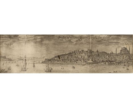
Lot 49
Sandys (George). Sandys Travailes: containing a History of the Original and Present State of the Turkish Empire ... the Mahometan Religion and Cermonies ... Constantinople ... Greece ... Egypt ... The Holy Land ... Italy ... and the Islands adjoyning; as Cyprus, Crete, Malta ... and other Places of Note, 6th edition, London: John Sweeting, 1658, engraved additional title-page, folding view of Istanbul, numerous engravings in the letterpress (including views, plans, costume, and antiquities), moderately browned, occasional staining, a few leaves slightly brittle and frayed along edges, repaired closed tears in gutter of engraved and letterpress titles and to inner fold of map, contemporary ownership inscriptions to front free endpaper (of which a large portion torn away), rear free endpaper excised, contemporary blind-ruled calf, front board detached, folio in 6s (29 x 19 cm), together with: Rycaut (Paul), The History of the Present State of the Ottoman Empire, 5th edition ('corrected and enlarged by the author'), London: by T. N. for Joanna Brome, 1682, 12 engraved plates, 17 full-page engravings in text, all depicting Ottoman costume, browning, leaves B6-8 chipped in lower margins, engraved bookplate of the earls of Harcourt, contemporary calf, covers detached, 8vo (18 x 11.5 cm), [Bancks, John], The History of the Life and Reign of the Czar Peter the Great, Emperor of all Russia, and Father of his Country, 1st edition, London: J. Hodges, 1740, engraved portrait frontispiece, toning, bookplate of John Hunter (d.1821) of The Hermitage, Hexham, contemporary calf, worn, 8vo (16.6 x 9.6 cm), Baronio (Cesare), Discours de l'origine des Russiens, et de leur miraculeuse conversion: et de quelques actes memorables de leurs rois ... traduict en françois du latin par Marc Lescarbot, 1st edition, Paris: Claude Morel, 1599, part 2 only (without part 1: 'Discours véritable de la réunion des Eglises d'Alexandrie & de Russie à la saincte Eglise catholique'), pp. [2] 59-101 [1], headlines trimmed, 18th-century marbled boards, small 8vo (15 x 9.5 cm), and 1 other (Wilkinson, Manners and Customs of the Ancient Egyptians, 1837-41, 4 volumes only, of 6) (Qty: 8)NOTESProvenance (Sandys): Sir Bindon Blood (1842-1940), British army officer (bookplate; pencilled ownership inscription dated 1920 to title-page). ESTC R1082 (Sandys), R33568 (Rycaut: four copies in UK libraries), T88910 (Banks: four copies in UK libraries); Wing S678 (Sandys), R2403 (Rycaut); cf. Blackmer 1484 for Sandys, 1621 edition ('at that time the most elaborately illustrated English book on the Levant'). Four copies of Baronio's work traced in libraries world-wide on OCLC.
![Scotland. Blaeu (Johannes), Fifae vice comitatus. The Sherifdome of Fyfe, Evia et Escia Scotis Evsdall et Eskdail [and] Orcad](https://cdn.globalauctionplatform.com/45651768-0840-4e6b-a25a-ab4401107d4e/c64a1417-0116-41c4-8e48-ab450107137d/468x382.jpg)
Lot 167
Scotland. Blaeu (Johannes), Fifae vice comitatus. The Sherifdome of Fyfe, Evia et Escia Scotis Evsdall et Eskdail [and] Orcadum et Schetlandiae Insularum accuarissima descriptio, Amsterdam, circa 1663, together three engraved maps with contemporary outline colouring, the map of the Orkney and Shetland Islands with text showthrough and slight toning, each approximately 425 x 530 mm, Fife and the Orkneys with Spanish text to verso, Eskdale with no text to verso (Qty: 3)
![* East Indies. Ortelius (Abraham), Indiae Orientalis Insularmumque Adiacenti..., [1601 - 1609], hand coloured engraved map, s](https://cdn.globalauctionplatform.com/45651768-0840-4e6b-a25a-ab4401107d4e/ce1ab527-4382-4b5c-9248-ab450106d67b/468x382.jpg)

Lot 85
Americas. Allard ( Carel ), Recentissima novi orbis sive Americae septentrionalis et meridionalis tabula, circa 1700, engraved map with contemporary hand colouring, insular California, some dust soiling, slight creasing, a little spotting to margins, central fold partially repaired on verso, 505 x 585 mm (Qty: 1)
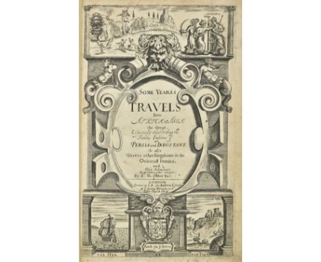
Lot 30
Herbert (Thomas). Some Years Travels into Divers Parts of Africa and Asia the Great, describing more particularly the Empires of Persia and Industan: interwoven with such remarkable occurrences as hapned in those parts during these later times. As also, many other rich and famous kingdoms in Oriental India, with the Isles adjacent, 3rd edition, London: J. Best for Andrew Crook, 1665, additional engraved title, folding engraved plate of Persepolis (torn with loss), engraved illustrations in text, lacks leaves 2G1 & 3K1, a few leaves close-trimmed, occasional light soiling and small stains,small marginal wormtrack to first few leaves, occasional early marginalia modern panelled calf gilt, two tiny wormtracks to lower cover, folio, together with: Chardin (John). The Travels of Sir John Chardin into Persia and the East-Indies... To which is added, the Coronation of this present King of Persia, Solyman the Third, 2 parts in one, 1st edition, 1686, additional engraved title (laid down), folding engraved map, 16 engraved plates, mostly folding, lacking engraved portrait, a few plates with tears and small mainly marginal losses, some water staining and soiling throughout, letterpress title and early leaves with some marginal insect damage, bookplate and shelf number, contemporary mottled calf gilt, small splits to joints, rubbed with some edge wear, folio (Qty: 2)NOTESWing H1534 & C2043.
Lot 4
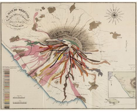
Auldjo (John). Sketches of Vesuvius, with Short Accounts of its Principal Eruptions, from the commencement of the Christian era to the present time, 1st UK edition, London: Longman et al., 1833, folding hand-coloured map, slightly edge-frayed with short closed handling tear, 16 uncoloured lithographed plates, several folding, a couple of short closed handling tears, modern boards, some light scratches and marks, printed paper labels to front cover and spine, 8vo (Qty: 1)NOTESNot in Abbey. First published in Naples the previous year.
Lot 82
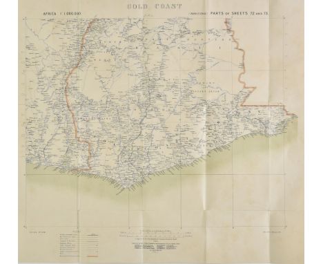
Africa. A mixed collection of maps of the Gold Coast and German East Africa, mostly 19th & early 20th century, engraved, lithographic and manuscript maps, including Ordnance Survey (publishers). German East Africa Mahenge, German East Africa Massassi, German East Africa Ikoma and another four regional maps similar, circa 1916, together seven colour printed maps, some marginal fraying caused by rodent damage, each approximately 670 x 770 mm, together with War Office (publisher), Gold Coast, 1907, colour lithographic map, old folds, 540 x 590 mm, with another similar but published by Ordnance Survey in 1906, with Wallach (Henry, surveyor). A Map of the Gold Coast with part of Ashanti showing the positions and Areas of Mining Properties, 1901, two large lithographic maps, sectionalised and laid on linen, some spotting, each approximately 1040 x 780 mm, with another nine printed and manuscript maps similar, various sizes and condition (Qty: 20)
Lot 126
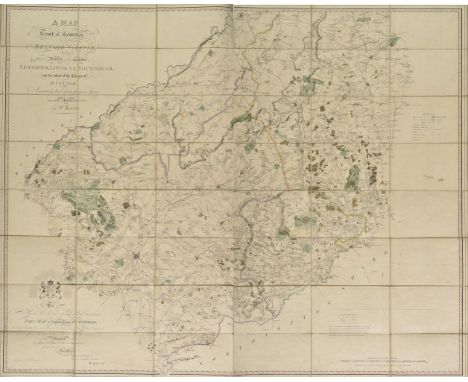
King (William). A Map of a Tract of Country Surrounding Belvoir Castle including extensive Districts of the Counties of Leicester, Lincoln & Nottingham; and the whole of the County of Rutland. Accurately laid down from a Survey taken in the years 1804. 5. & 6. engraved and sold by W. Faden, published Knipton, Nov. 8th, 1806, large scale engraved map with contemporary outline colouring, sectionalised and laid on linen, calligraphic title and dedication and mileage scale, slight dust soiling and very slight spotting, 1150 x 1440 mm, map seller's label (W. Faden) to verso, lacking slipcase (Qty: 1)NOTESUncommon.

Lot 101
Carnarvonshire . Speed (John), Caernarvon both Shyre and Shire-towne with the ancient Citie Bagor described, published Thomas Bassett & Richard Chiswell [1676], hand coloured engraved map, inset town plans of Bangor and Carnarvon, trimmed to neatline, 385 x 510 mm, English text on verso (Qty: 1)
![Van den Keere (Pieter). Twelve maps of Scotland and Ireland, [1627 or later], twelve uncoloured engraved miniature maps of Sc](https://cdn.globalauctionplatform.com/45651768-0840-4e6b-a25a-ab4401107d4e/5ee37427-9669-4db1-ab20-ab4501071c52/468x382.jpg)
Lot 176
Van den Keere (Pieter). Twelve maps of Scotland and Ireland, [1627 or later], twelve uncoloured engraved miniature maps of Scotland and Ireland, bound with their respective pages of descriptive text, index bound at rear, some water staining, map of the Kingdom of Scotland trimmed with slight loss, later endpapers, front endpaper with 20th century manuscript ownership signature and a blindstamped address, 19th century calf gilt over marbled boards, slight wear to extremities, slim oblong 8vo (Qty: 1)NOTESAppears to be a portion from the atlas 'England Wales Scotland and Ireland Described' . Sold as a collection of maps, not subject to return.

Lot 110
Eastern counties. Bill (John), Cambridgeshire and Isle of Ely, 1626, uncoloured engraved miniature map, small margins, 90 x 120 mm, English text on verso (text trimmed), mounted, together with Meisner (Daniel). Remedia as Sanitatem Servandam Creata sunt Nordovicum Angl. [1638], uncoloured engraved city plan of Norwich, 100 x 145 mm, with Bowles (Carington, publisher). Bowles's Reduced map of Norfolk, [and] Bowles's Reduced Map of Essex, (1769], two uncoloured engraved maps, old folds, each approximately 220 x 300 mm, with another five maps of Essex, Suffolk, Huntingdonshire and Cambridge, including examples by Seller/Grose, Seller, Cole & Roper, Bowles and Kitchin, various sizes and condition (Qty: 9)
![Northamptonshire. Smith (William), Northamptoniae Comitatus Descriptio....., J.Overton [1675 or later], hand coloured engrave](https://cdn.globalauctionplatform.com/45651768-0840-4e6b-a25a-ab4401107d4e/d0a8ff04-dd4f-4ed1-a96b-ab450106f289/468x382.jpg)
Lot 139
Northamptonshire. Smith (William), Northamptoniae Comitatus Descriptio....., J.Overton [1675 or later], hand coloured engraved map, large strapwork cartouche and mileage scale, toned overall, 365 x 480 mm (Qty: 1)NOTESWilliam Smith, antiquary and cartographer, was a contemporary of Christopher Saxton. He only completed twelve maps which were probably intended for an uncompleted English atlas. The maps were individually first published in 1602, and the plates were acquired by John Overton in 1670. Until comparatively recently their authorship was doubtful and they were known as the 'Anonymous Maps'. All of Smith's maps are considered scarce.
![[Castro, Casimiro]. [Album del Ferrocarril Mexicano, colleción de vistas, 1st edition, Mexico City: Victor Debray, 1877 or 18](https://cdn.globalauctionplatform.com/45651768-0840-4e6b-a25a-ab4401107d4e/b4be4cb5-8e6c-4196-b4b3-ab4501067e09/468x382.jpg)
Lot 11
[Castro, Casimiro]. [Album del Ferrocarril Mexicano, colleción de vistas, 1st edition, Mexico City: Victor Debray, 1877 or 1878], 2 parts in 1 volume, pp. 15-40 43-56, [2] 1-18 (i.e. lacking main title-page, pp. 1-14 and 41/2), first part with English and Spanish text in double column, second part in French (with separate title-page), chromolithographic additional title-page, 23 chromolithographic plates (of 24: lacking plate 23), double-page chromolithographic map, map with short closed tear near central fold and old marginal repair verso, marginal damp-staining to plates, just encroaching on upper outer corners of images towards rear, plates 1-4 slightly spotted, plate 24 slightly softened along edges, plates 14 and 20 strengthened along bottom edge verso (repairing closed tears), gilt edges, original cloth (front board dated 1878), spine defective, front board loose, cloth worn away and lifting at extremities, oblong folio (Qty: 1)NOTESThe vibrant chromolithographs depict bridges, stations and views along the railway, as well as views of Veracruz, Huamantla, Cordoba and Orizaba. The double-page map is titled 'Plano orografico de la zona recorrida por el ferro-carril Mexicano de Veracruz a Mexico formada por Antonio Garcia Cubas'.

Lot 178
* Warwickshire. Speed (John), The Counti of Warwick. The Shire Towne and Citie of Coventre described, John Sudbury & George Humble, [1627], uncoloured engraved map, inset town plans of Warwick and Coventry, some water staining, central fold repaired at base but not affecting image, 385 x 515 mm, English text on verso, framed and double glazed (Qty: 1)

Lot 168
Scotland. Van Keulen (Johannis), Nieuwe Paskaert vande oost cust van Engeland en Schotland beginnende van't Flamburger Hoost totaan de Rivier van Eedenborg zynd Naaukeurigh opgestelten van veel Fouten verbeetert, circa 1685, uncoloured engraved chart of the east coast of England from Flamborough Head to the Firth of Forth, inset map of Newcastle and the River Tyne, orientated to the east, compass rose and numerous rhumb lines, slight creasing, slight staining to central fold, 510 x 595 mm, together with Collins (Captain Greenville). The East Coast of Scotland with the Isles of Orkney and Shetland..., circa 1790, uncoloured engraved chart, some dust soiling, slight staining, some fraying to margins, 450 x 560 mm, with Mount (Richard & Page Thomas, publishers). A New Chart of the Sea Coast of Scotland with the Islands thereof, circa 1740, uncoloured engraved chart, inset map of Holy Island and the Staples, old folds, 475 x 535 mm (Qty: 3)

Lot 180
World. Le Rouge (George Louis), Mappe Monde Nouvelle Dediéer a Monseigneur le Comte de Maurepas Ministre et Secretaire d'Etat, Paris, 1744, engraved map on a hemispheral projection with contemporary outline colouring, the margins decorated with uncoloured allegorical images based around the emerging sciences of the day, some worming repaired on verso, 515 x 725 mm (Qty: 1)
Lot 170
* Somerset. Saxton (Christopher), Somersetensem Comitat (agri fertiltate Celebrem) hec ob oculos ponit Tabula. Anno 1575. et D.Elizabethe Regine Ao 17, [1579], engraved map with contemporary hand colouring, ornate heraldic and strapwork cartouche and mileage scale, with the arms of Thomas Seckford in the lower right corner, 395 x 520 mm (Qty: 1)NOTESPublished in 'An Atlas of England and Wales', this is a fine example of a map from the first complete English atlas. Saxton was a Yorkshireman who was educated at Cambridge and attached to the household of Thomas Seckford at whose instigation and expense and with the Authority of Queen Elizabeth, he surveyed and drew the first county maps of the Kingdom. The map was engraved by Lenaert Terwoort whose name appears beneath the mileage scale. T.Chubb. Maps of Somerset 1579 - 1914, no.1.
![* Ogilby (John). The London from London to Kings Lyn com. Norfolk, [1676 or later], hand coloured engraved strip road map, 34](https://cdn.globalauctionplatform.com/45651768-0840-4e6b-a25a-ab4401107d4e/58b5cfd9-87b2-467a-a979-ab450106f4f0/468x382.jpg)
Lot 143
* Ogilby (John). The London from London to Kings Lyn com. Norfolk, [1676 or later], hand coloured engraved strip road map, 340 x 450 mm, mounted with two pages of contemporary descriptive text, mounted, framed and glazed (Qty: 1)NOTESThe road runs from Pickering, through Cambridge, Ely and Downham, ending at Kings Lynn.

Lot 95
British Isles. Blaeu (Johannes), Britannia prout divisa suit temporibis Anglo-Saxonum praesertim durante illorum Heptarchia, Amsterdam, circa 1657, engraved map with contemporary hand colouring, vertical margins decorated with 14 scenes of Saxon figures and events, slight staining to margins, 415 x 535 mm, Spanish text on verso (Qty: 1)NOTESR. W. Shirley, Early Printed Maps of the British Isles 1477-1650 , no. 549.
![Northern Counties. Simmons (Matthew), Westmerland , [1636], uncoloured engraved triangular mileage table with a 'thumb-nail'](https://cdn.globalauctionplatform.com/45651768-0840-4e6b-a25a-ab4401107d4e/4385f047-8d42-4ed6-ade0-ab450106f332/468x382.jpg)
Lot 140
Northern Counties. Simmons (Matthew), Westmerland , [1636], uncoloured engraved triangular mileage table with a 'thumb-nail' map in the lower right corner, overall size 100 x 100 mm, together with Meisner (Daniel), Carcer nonnunquam firmum prougnaculum. Hull in Engellandt, circa 1638, uncoloured engraved town plan, 100 x 140 mm, with Hermannides (Rutger). Lancastria Lancaster, [1661], hand coloured engraved town plan, 105 x 130 mm, plus Saxton (Christopher & Hole G.). Eboracensis comitatus pars Septentrionalis vulgo North Riding, [1607], hand coloured engraved map, some mount staining and toning, 200 x 350 mm, Latin text on verso, with another five county maps of Cheshire, Yorkshire and Cumberland with examples by Morden (Large), Van Langran, Bowles, Cary and Ellis, various sizes and condition (Qty: 9)
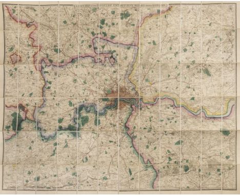
Lot 133
London. Wyld James, publisher), A New Map of the Country Twenty-five Miles round London, circa 1860. engraved map with bright contemporary hand colouring, sectionalised and laid on linen, 1040 x 1315 mm, marbled endpapers, contained in a contemporary cloth slipcase with publisher's printed label to upper cover, case partially split along joints, together with: Cary (John). Cary's New Pocket Plan of London Westminster and Southwark with all the adjacent Buildings in St. George's Fields &c. &c., 1825, engraved map with contemporary hand colouring, sectionalised and laid on linen, slight staining, 420 x 605 mm, marbled endpapers, contained in a contemporary card slipcase with printed title label to upper cover, case worn, Bacon (G. W., publisher). Bacon's Map of the Environs of London 12 Miles around Charing Cross, circa 1880, folding lithographic map with contemporary outline colouring, 640 x 795 mm, bound in contemporary cloth boards with decorative title label to upper cover, boards worn and faded, plus 1 0 other folding maps of London, The Thames Estuary and The River Thames, with examples by Stanford, Ravenstein, Reynolds, Ward and Ordnance survey, various sizes and condition (Qty: 13)

Lot 153
Poland. Lotter (Tobias Conrad), Polonia Seraphica Observans..., Augsburg, 1754, engraved map with contemporary hand colouring, large uncoloured allegorical cartouche showing Franciscan monks and friars praying to the Virgin Mary and the Christ Child, old folds, trimmed to neat line, 495 x 565 mm, together with Schenk (Pieter & Valk Gerard). Ducatus Breslanus sive Wratislaviensis [and] Ducatus Silesiae Wolanus..., circa 1700, together two engraved maps with contemporary hand colouring, some additional later colouring to the cartouche of the map of Breslanus, each approximately 390 x 480 mm, with Visscher (Nicolas). Regnum Bohemiae eique Annexae Provinciae Sileaiase Marchionatus Moraviae et Lusatiae vulgo Die Erb-Landeren, Amsterdam, circa 1740, engraved map with contemporary hand colouring heightened with gold, 500 x 590 mm (Qty: 3)

Lot 138
North America. Schenk (Pierre), L'Amerique Septentrionale Dressee sur les Observations de Mrs. de l'Academie Royale des Sciences..., Par G. de l'Isle, Amsterdam, circa 1710, engraved map with contemporary hand colouring, uncoloured decorative cartouche, slight creasing and marginal staining, repaired closed tears affecting image, some cracking caused by oxidisation of watercolour, repaired on verso, 455 x 590 mm (Qty: 1)
![* Prussia. Schleuen (Johann David). General-Carte der Gesamten Koniglichen Preussischen Lander..., Berlin, [circa 1750], engr](https://cdn.globalauctionplatform.com/45651768-0840-4e6b-a25a-ab4401107d4e/ba79a2dd-91c8-4bad-9d7f-ab4501071014/468x382.jpg)
Lot 162
* Prussia. Schleuen (Johann David). General-Carte der Gesamten Koniglichen Preussischen Lander..., Berlin, [circa 1750], engraved map with contemporary outline colouring on two conjoined sheets, inset views of Berlin, Breslau and Konigsberg, one old fold, 580 x 705 mm, mounted, framed and glazed (Qty: 1)NOTESA rare map of Northern Germany and part of Poland.

Lot 157
* Poland. Seutter (Matthaus), Wratislavia Antiquissima et Celeberrima Ducat. Silesiaci Metropolis..., / Breslau due Uhralte u Hochberuhmte Haupt Statt des Herzogth. Schleisien..., Augsburg, circa 1740, engraved city plan of Wroclaw with contemporary hand colouring, uncoloured panorama and two allegorical vignettes below map, small repaired hole affecting image, occasional repaired marginal closed tears, laid on card, 500 x 580 mm, mounted, framed and glazed (Qty: 1)

Lot 21
De Vaugondy (Robert). Nouvel Atlas Portatif destine principalement pour L'instruction de la Jeunesse d'apres la Geographie Modern de seu L'Abbe Delacroix, published S. Delamarche, Paris, 1795, decorative engraved title, introduction and contents list, 54 double-page engraved maps all with contemporary outline colouring (52 called for in index but there is a duplicate of 'Carte des premiers ages du monde' and an additional large folding map of France), maps re-guarded, map of Germany with sparse manuscript annotation to title, some spotting and ink staining throughout but largely confined to margins, slight creasing and fraying to foredge on first few leaves, pastedowns stained and with juvenile drawings to rear endpaper, contemporary quarter calf, on marbled boards with faint manuscript annotation to upper siding, corners repaired, worn and frayed, 4to (Qty: 1)
-
109198 item(s)/page