A rare prototype lithographed board for a London Underground map game,1909, designed by John Waddington Ltd., London, showing the 1908 London Underground Railways map as issued in mid-1908, printed by Johnson Riddle & Co.,20 x 27cmCondition ReportSome damage to top edge and coating has slightly darkened with age. Lithograph on board.
We found 109182 price guide item(s) matching your search
There are 109182 lots that match your search criteria. Subscribe now to get instant access to the full price guide service.
Click here to subscribe- List
- Grid
-
109182 item(s)/page
A collection of thirty-eight Westminster City Council defence planning documents, 1952, to include surveys on buildings within Westminster, two copies of revised schemes, one trench shelter survey, one ad hoc survey, and one hardback Public Shelter Survey (including folding map) published 1954, forty-three items in total relating to shelters in the event of an air attack (43)Condition ReportOne duplicate. Thumbing at the edges. Staining. Rust to the staples. Folding creases to the map.
A map of St Luke's Hospital for Lunatics,1755, a hand-coloured map of 'St. Luke's Hospital for Lunatic's in Upper Moorefields', executed by Benjamin Cole, inscribed 'Cripplegate Ward with it's Division into Parishes according to a new Survey - This Plan is most humbly Inscrib'd to John Blachford Esqr. Alderman of Cripplegate Ward in 1755', 37 x 24cm, framedCondition ReportWith folding creases evident. Some foxing along the lower edges.
John Speed, 'Leicester both Countye and Citie described...', hand-coloured map, published by John Sudbury and George Humble, dated 1610, 35x51cm.Condition report:This isn't a modern print. It is framed and glazed. It is in very good condition, with just some slight discolouration consistent with age, but no worm holes, water marks or stains.
An interesting album relating to Oxford City Football Club Tour to Austria and Hungary, Easter, 1913, with itinerary, approximately forty-one black and white photographs of the tour including some match examples, business cards, a handwritten diary relating to the tour and a town map of Budapest, all stuck down within privately produced album
THE STRANGLERS - LP / 12" / 7" PACK. A heroic pack of 3 x LPs, 2 x 12" and 7 x 7". Titles include Raven (UAG30262, 3D Sleeve, Includes Insert with map, Strong VG+ Record / Ex+ Sleeve), Black and White (US pressing SP.4706 ltd edition grey vinyl pressing - Ex+ condition record super clean, includes 7" white vinyl - Ex+/with printed inner/Ex condition LP sleeve), Rattus Norvesgicus (UK UAG 30045 - Ex condition LP/complete with Pleasant In the Big Shitty 7" - lovely Ex+/with printed inner/Ex LP sleeve), Skin Deep (TA4738 - VG+/Ex), Paradise (TA3387 - Ex+/Ex), Spectre of Love (3750357, ltd edition green vinyl 7" - Ex+/Ex), Peaches (2564633531, sealed 2014 RE), Grip '89 (Get A) GRIP (On Yourself) (EMR84, red vinyl - Ex/Ex+), Walk On By (2015 RSD ltd edition coloured 7", 7-547634 - Ex+/'as new') and All Day And All Of The Night (7" pic disc, VICE P1 - Ex+ condition).
FOLK / COUNTRY / SINGER SONGWRITER - LP COLLECTION. A collection of around 107 x LPs. Artists/ Titles include The Pentangle inc. Basket of Light, ...At Their Best, Fairport Convention - Glady's Heap, Strawbs - Grave New World, Paul Simon - The Rhythm of the Saints, Donovan - Donovan, Ry Cooder - Get Rhythm, Joan Armstrong - Steppin' Out, Steve Goodman - Somebody Elses Troubles, Gerry Rafferty, Dan Fogelberg - Nether Lands, Paul Metsers, Joe Egan - Map, Kevin Peek - Awakening, Judy Collins - Whales & Nightingales, Carly Simon - Anticipation and Dave Mason - Split Coconut. The condition is generally VG to Ex / Ex+.
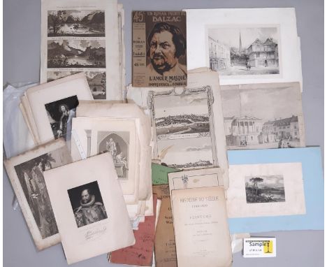
A folder containing engravings, maps and others to include: Maps of Essex: 'Guide to Southend' published by G. Mann 39 Cornhill London, inscribed 1860; Honoré de Balzac - 'L'Amour Masque ou Imprudence et Bonheur', 1911; New Business Map of South Eastern Essex, Scott & Co. Leicester; Topographical Guide and Director to Southend-on-Sea, Westcliff-n-Sea & District; H. Robinson - engraving of HRH Prince Augustus-Frederick, Duke of Sussex, Fisher & Son Co. London, 1844; 19th century and earlier engravings and lithographs of monarchs including: Richard II, Elizabeth I, Malcolm Canmore III, Henry II and III, Catherine Howard, William III, George I, II and III, Edward I and II and others; 19th century divines engravings: R Rolfe - Rev. James Slye, published 1828; Rev. Coombs published 1824; T.A. Dean - Rev. James Scott, published 1830; Rev. Francis Close; and others; Pre 1700 divines: After Hans Holbien - portrait of Martin Luther; and others - lords and noblemen, cardinals and bishops, authors; R.W. Wallis - 'The City of Astracan, the Capital of Tartary, engraving; and other 19th century maps and engravings of Essex and other areas
Four framed items including two maps: Robert Morden (c.1650-1703) - 'Cornwall', hand-coloured engraving on laid paper, 42 x 47 cm; After John Cary (1754-1835) - 'Gloucestershire', hand-coloured engraving, London published Jan 1st 1793 by J.Cary Engraver & Map seller, Strand, 26 x 21 cm; After Michael Angelo Rooker (1743-1801) - 'Barrington near Burford in Gloucestershire, the Seat of the Countess of Talbot', hand-coloured engraving, published by G.Kearsly, 1776, 13 x 20 cm; all framed and glazed; together with a cast brass plaque (4)
A SMALL GROUP OF SIX PICTURES AND PRINTS, comprising George Willis Pryce (1866-1949) 'Bracebridge Pool, Sutton Park' a water landscape signed bottom left, artist label verso, oil on board, approximate size 19cm x 24cm, George Henry Downing (1878-1940) a figure walking along a woodland path, signed bottom left, watercolour on paper, approximate size 50cm x 38cm, 'Aston Church' attributed to Rev George Fenwick circa mid 1900, watercolour on paper, a modern landscape oil on canvas signed Ann, Stephen Doig 'Wonderful life' a signed limited edition print featuring Cliff Richard and a reproduction map of the world (6)
A 1943 MAP OF JAVA Printed on March 10th and issued on March 15th 1943, with a vignette of northern Australia 54cm x 76cm Condition: For a condition report or further images please email hello@hotlotz.com at least 48 hours prior to the closing date of the auction. This is an auction of preowned and antique items. Many items are of an age or nature which precludes their being in perfect condition and you should expect general wear and tear commensurate with age and use. We strongly advise you to examine items before you bid. Condition reports are provided as a goodwill gesture and are our general assessment of damage and restoration. Whilst care is taken in their drafting, they are for guidance only. We will not be held responsible for oversights concerning damage or restoration.
A MAP OF JAPAN (20TH CENTURY) 20th century With insets of the Yezo, Kumamoto and Tokyo Region From 'The Times' Atlas. Artists and Engravers Published by the Edinburgh Geographical Institute and John Bartholomew & Co. 56cm x 43cm (without frame) Condition: For a condition report or further images please email hello@hotlotz.com at least 48 hours prior to the closing date of the auction. This is an auction of preowned and antique items. Many items are of an age or nature which precludes their being in perfect condition and you should expect general wear and tear commensurate with age and use. We strongly advise you to examine items before you bid. Condition reports are provided as a goodwill gesture and are our general assessment of damage and restoration. Whilst care is taken in their drafting, they are for guidance only. We will not be held responsible for oversights concerning damage or restoration.
A MAP OF THE THE BRITISH ROUTE FROM TURON BAY TO PEKING Engraving with hand colouring by John Barrow, engraved by B. Baker, titled 'A Chart on Mercator's Projection, containing the Track and Soundings of the Lion, the Hindostan and Tenders, from Turon Bay in Cochin-China to the mouth of the Pei-Ho River in the Gulph of Pe-Tche-Lee or Pekin'. This detailed chart was published in 'An Authentic Account of an Embassy from the King of Great Britain to the Emperor of China' and shows the route of the vessels carrying the embassy along the China coast Sheet size 80 x 59cm Condition: For a condition report or further images please email hello@hotlotz.com at least 48 hours prior to the closing date of the auction. This is an auction of preowned and antique items. Many items are of an age or nature which precludes their being in perfect condition and you should expect general wear and tear commensurate with age and use. We strongly advise you to examine items before you bid. Condition reports are provided as a goodwill gesture and are our general assessment of damage and restoration. Whilst care is taken in their drafting, they are for guidance only. We will not be held responsible for oversights concerning damage or restoration.
A FRENCH MAP OF THE ROUTE OF THE ENGLISH AMBASSADOR IN CHINA Hand coloured engraved map titled 'Carte de la Route que L'Ambassade Anglaise a suivie en allent de Hang-Tchou-Fou a Quang-Tchou-Fou ou Canton en Chine', by Tardieu L'aine, Rue de Sorbonne, circa 1800, unframed 65 x 47cm Condition: Condition Report The lefthand margin with large repair to reverse and many other small repairs to the page edges on reverse vertical and horizontal folds This is an auction of preowned and antique items. Many items are of an age or nature which precludes their being in perfect condition and you should expect general wear and tear commensurate with age and use. We strongly advise you to examine items before you bid. Condition reports are provided as a goodwill gesture and are our general assessment of damage and restoration. Whilst care is taken in their drafting, they are for guidance only. We will not be held responsible for oversights concerning damage or restoration.
A MAP OF THE SOUTHERN HEMISPHERE (1778) From 'Histoire Generale des Voyages' - A French edition of Capt James Cook's famous chart, first printed in London in 1777 with Cook's second voyage report. A key piece in Captain Cook's exploration collection! This map; engraved by Benard and printed from 1778 onward, depicts his first and second voyage's tract, together with the voyages of famous Captains such as Tasman, Bougainville, Wallis, Halley, Bouvet and others. Capt Cook 's second voyage, between 1772 and 1775, was commissioned by the British Goverment under advice from the Royal Society to explore the fabled Terra Australis or great Southern land. He proved the Terra Australis incognita to be a myth and predicted that an Antartic land would be found beyond the ice barrier. Even though Capt Cook circumnavigated Antartica, his chart shows no existance of the Continent. Ice was rarely marked on a map as it was assumed it would keep changing its shape. 53cm x 53cm Condition: Good condition, folds as issued, map has been restored
ANTIQUE FRENCH NORTHERN AND SOUTHERN HEMISPHERE MAPS (1789) Rigobert Bonne, engraved by Gaspard Andre (fl.1768-1801) Copper plate engraving with hand colouring 25cm high x 36cm wide each map Condition: Good with colours refreshed, fold as issued, restored to remove central bracket on the back.
A VERY LARGE REPRODUCTION MAP OF SINGAPORE CITY Of Singapore during the early 20th century, depicting Albert Street to Victoria Dock, and Killiney Road to Johnston Pier 162.5 cm high x 214.5cm wide Condition: For a condition report or further images please email hello@hotlotz.com at least 48 hours prior to the closing date of the auction. This is an auction of preowned and antique items. Many items are of an age or nature which precludes their being in perfect condition and you should expect general wear and tear commensurate with age and use. We strongly advise you to examine items before you bid. Condition reports are provided as a goodwill gesture and are our general assessment of damage and restoration. Whilst care is taken in their drafting, they are for guidance only. We will not be held responsible for oversights concerning damage or restoration.
A 1770 FRENCH MAP OF THE INDIAN SUBCONTINENT Published by Desnos, Paris " Carte de la partie meridionale de la Presqu'ile des l'Inde en deca du Gange ", a map designed by Brion de la Tour, Geographer to the King Presented in a gold-colour wooden frame 53cm long x 43cm high with frame Condition: Condition Report Good condition, maps as issued, washed This is an auction of preowned and antique items. Many items are of an age or nature which precludes their being in perfect condition and you should expect general wear and tear commensurate with age and use. We strongly advise you to examine items before you bid. Condition reports are provided as a goodwill gesture and are our general assessment of damage and restoration. Whilst care is taken in their drafting, they are for guidance only. We will not be held responsible for oversights concerning damage or restoration.
AN ANTIQUE MAP OF 'THE EAST INDIA ISLES' Drawn and engraved by I.Dower and published by Orr & Co, London in 'A General Descriptive Atlas Of The Earth', circa 1832 22x26cm Condition: For a condition report or further images please email hello@hotlotz.com at least 48 hours prior to the closing date of the auction. This is an auction of preowned and antique items. Many items are of an age or nature which precludes their being in perfect condition and you should expect general wear and tear commensurate with age and use. We strongly advise you to examine items before you bid. Condition reports are provided as a goodwill gesture and are our general assessment of damage and restoration. Whilst care is taken in their drafting, they are for guidance only. We will not be held responsible for oversights concerning damage or restoration.
Robert Morden (1650-1703) - Coloured engraving - Map of Gloucestershire, 14.5ins x 17ins, and R Creightom (18th Century), J&C Walker (19th Century) - Map of Devonshire, engraved for Lewis Topographical Dictionary, 9.5ins x 10.5ins, and two other coloured engravings and two later prints, all framed and glazed
COMIC MAP OF EUROPE, LATE 19TH CENTURY CARICATURE MAP,based upon Paul Hadol's popular prototype of 1870, hand-coloured lithograph, approx. 28cm x 42cm, mounted, framed and under glassThe map itself appears generally good. Foxing above the OF, and same position to bottom edge. Some other minor areas to edge, and yellowing of paper but generally good for age. Frame worn and would benefit from reframing. Additional images now available.
FOUR ENGLISH COUNTY MAPS, BOWEN (THOMAS),circa 1780, comprising Essex, Oxforshire, Shropshire and Yorkshire, each hand-coloured, mounted, framed and under glass, the largest Yorkshire at 37cm x 48cm overall, along with a map of Lancashire, pub. Fullarton of Glasgow, circa 1840s, and London by Edward Weller, circa mid-19th century, both also framed (6)
-
109182 item(s)/page