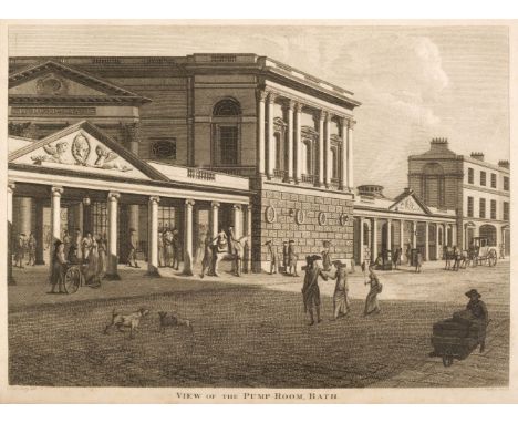

Warner (Richard). The History of Bath, 1st edition, Bath: Printed by R. Cruttwell, 1801, half-title discarded, engraved portrait frontispiece, folding engraved map, 13 engraved plates, some toning and scattered spotting, offsetting from plates, few leaves at rear damp stained at foot, later endpapers retaining 19th century bookplate of Alfred Thrale Perkins, 20th century bookplate and ownership signature to front endpaper, hinges split, contemporary diced calf, rebacked preserving spine, board edges worn, 4to, together with: Bath, The New Bath Guide; or, useful pocket companion for all persons residing at or resorting to this antient city. Giving an account of the first discovery of its medicinal waters by King Bladud..., new edition, improved and much enlarged, Bath: Printed by R. Cruttwell, 1785, engraved portrait frontispiece, engraved folding map, four engraved plates, original stab holes at gutter where previously sewn (with few leaves neatly strengthened to gutter margins, including frontispiece & title), original plain wrappers bound-in, modern calf-backed marbled boards, maroon morocco title label to spine, slight fading to spine, 12mo, Warner (Richard), A New Guide through Bath, and its environs, Bath: Printed & sold by Richard Cruttwell, 1811, ink stamp crest to title, ownership name and date to dedication leaf 'L. Clutterbuck, 3rd Nov. 1813', modern bookplate and ownership signature to front endpaper, contemporary green half calf, blind decorated spine with red morocco title label, extremities slightly rubbed, 12mo, and two other Bath related, Mainwaring (Rowland), Annals of Bath, from the year 1800 to the passing of the new Municipal Act, Bath: Printed by Mary Meyler & Son, 1838, and Britton (John), The History and Antiquities of Bath Abbey Church, London: Printed for the author, 1825Qty: (5)
We found 109182 price guide item(s) matching your search
There are 109182 lots that match your search criteria. Subscribe now to get instant access to the full price guide service.
Click here to subscribe- List
- Grid
-
109182 item(s)/page

Geikie (Archibald). The Ancient Volcanoes of Great Britain, 2 volumes, London: Macmillan and Co., 1st edition, 1897, numerous black & white illustrations & maps, some light spotting, publishers original uniform green cloth, spines lightly rubbed to head & foot, 8vo, together with; Forbes (James D.), Norway and its Glaciers visited in 1851, 1st edition, Edinburgh: Adam and Charles Black, 1853, monochrome map plus folding map to the rear, 14 colour & monochrome illustrations, period inscription to the head of the front endpaper some light toning, publishers original embossed cloth, boards & spine slightly rubbed to head & foot, 8vo, plus Vahl (M. et al), Greenland, published by the commission for the direction of the geological and geographical investigations in Greenland, 3 volumes, Copenhagen: C. A. Reitzel, 1928, some minor toning, contemporary uniform light blue cloth, boards & spines lightly rubbed, large 8vo, and other late 19th & early 20th-century geological reference & related, including Notes on the Geology & Natural History of the County of Durham, by Robert Calvert, Bishop Auckland: printed by W. J. Cummins, 1884, 8vo, mostly in publishers original cloth, 8voQty: (19)

Macpherson (H. A.). A Vertebrate Fauna of Lakeland..., Edinburgh: David Douglas, 1892, 9 monochrome full page illustrations including the rear folding map, black & white advertisements to the rear, later endpapers, top edge gilt, rebound in later gilt decorated green quarter morocco, spine lightly rubbed, 8vo, together with; Wheldon (J. A. & Albert Wilson), The Flora of West Lancashire..., Liverpool: Henry Young & Sons, 1907, 15 black & white illustrations plus a colour folding map to the rear, previous owner ink stamp to the front endpaper, some light marginal toning, publishers original green cloth, boards & spine lightly rubbed to head & foot, 8vo, plus Painter (W. H.), A Contribution to The Flora of Derbyshire..., London: George Bell & Sons, 1889, colour folding map, bookplate to front pastedown, some light toning & spotting, publishers original green cloth, boards & spine slightly rubbed to head & foot, 8vo and other late 19th & early 20th-century county flora & fauna reference, including The Flora of Cheshire, by Lord De Tabley, London: Longmans, Green, and Co., 1899, 8vo, all in publisher's original cloth, 8voQty: (22)

An interesting Second War O.B.E. group of five awarded to Mr Otway H. Little, Director of the Geological Survey of Egypt, late Lieutenant, 7th Field Survey Company, Royal Engineers, who was taken prisoner by the Turks in April 1916 and imprisoned at Yozgad, where he featured as one of the characters in E. H. Jones’ book The Road to En-dor, widely regarded as one of the most remarkable prisoner-of-war escape stories ever The Most Excellent Order of the British Empire, O.B.E. (Civil) Officer’s 2nd type breast badge, silver-gilt, in its Royal Mint case of issue; 1914-15 Star (Lieut. O. H. Little. R.E.); British War and Victory Medals (Lieut. O. H. Little.); Egypt, Kingdom, Order of Ismail, Officer’s breast badge, 75mm including crown suspension x 56mm, gold and enamels, reverse with Egyptian maker’s mark, and stamped with gold and silver marks, each with date letter ‘A’, suspension pin replaced with pin brooch to reverse of crown suspension, some minor enamel chips to the last, otherwise nearly extremely fine (5) £1,200-£1,500 --- O.B.E. (Civil) London Gazette 3 March 1944: ‘For services to the Forces and in connection with Military operations [all awards for Egypt]:- Otway Henry Little, Director of the Geological Survey, Egyptian Ministry of Finance. For scientific services.’ Order of Ismail, 4th Class, permission to wear London Gazette 29 July 1949: ‘For valuable services rendered by him in the capacity of Director of the Geological Section of the Egyptian Mines Department.’ Otway Henry Little, a graduate of Trinity College, Dublin, joined the Geological Survey of Egypt in November 1912. His first two field seasons were spent with the late John Ball in west-central Sinai on the last of those great expeditions of the Egyptian Survey which produced such valuable monographs on the geology of the desert. Then came the 1914-18 war and Little, who had joined the 7th Field Survey Company, Royal Engineers, was taken prisoner by the Turks in their successful raid on Qatia and Oghratina in April, 1916. Little was imprisoned at Yozgad and readers of that lively book The Road to En-dor will find mention of him in its pages. After his release, Little’s first mission was to southern Arabia 1919-20 and he reported on this in The Geography and Geology of Makalla, published in 1925. Returning to Cairo, Little found the Geological Survey greatly curtailed in scope and power. “Petroleum research” had been assigned to an independent department; the mapping of the desert to another. Field work was almost at a standstill, while, in the office, his chief’s attention was largely absorbed in amassing material for a work on The Geology of Egypt, which was never finished. Little had to abandon research and concentrate on the administrative task of keeping the Survey in being and, when time permitted, in compiling the 1:1,000,000 geological map of Egypt. From time to time he escaped from his office to investigate the water supplies of the oases, and A Preliminary Report on the Water Supply of Dakhla Oasis and (with M. Attia) The Deep Bores in Kharga and Dakhla contained valuable recommendations on the control of drilling new wells, to which the Egyptian Government paid little heed. In 1928, Little succeeded W. F. Hume as Director of the Geological Survey. In 1934, with Dr L. J. Spencer of the Natural History Museum, he took part in the field investigation of a remarkable find by Mr. (now Colonel) P. A. Clayton of the natural silica glass in the Sand Sea near the Egyptian-Libyan border. Many specimens, including some beautiful glass artefacts of the Acheulean type, were brought back but no satisfactory explanation of the occurrence was forthcoming. During the Second World War, Little placed his great experience of desert water supply at the service of the chief engineer, M.E.F., and was later awarded the O.B.E. In 1949, he retired and settled in South Africa, where his latter years were clouded by ill-health. He died near Stellenbosch, Cape Province, in October 1956. Little took life philosophically and with great good humour so that he made no enemies. In Cairo, he was always ready to welcome visitors to his museum and library and to help, when needed, with information and advice based on his own researches. Incapable of malice or spite, he was loved by his Egyptian colleagues and subordinates. As the head of an allied section of the Survey of Egypt, I always found Little a loyal colleague in the joint approaches we had often to make to the powers over us. Little was a valued member of the oldest scientific body in Egypt, the Institut d’Egypte, and served a term as its Vice-President.’ (Obituary by G. W. Murray from Proceedings of the Geological Society of London (1957) refers). Sold with mounted group of miniatures of the first four, silver medal of the ‘Institut Egyptien’, bronze medal of ‘Congres International de Geographie Le Caire 1925, and four enamelled badges for Geological Conventions for 1922 (2), 1929 and 1948, the last with name tag ‘Mrs D. Little’, together with comprehensive research.

W Britain (Britains) No.9494 Knight of Agincourt, comprising of a single lead knight mounted on a horse, with lance and shield, fixed arms, boxed; Crescent B.185 painted lead figure of a pilot in a flying suit, holding a map case, rectangular base; John Hill & Co. 267MC RAF mechanic figure, circular base, each unboxed (2); W Britain (Britains) No.1611 British Infantry in steel helmets and gas masks, comprising single figure with spade, movable arms, rectangular base, unboxed; No.1612, comprising single figure throwing a grenade, fixed arms, rectangular base, unboxed (2) [5]
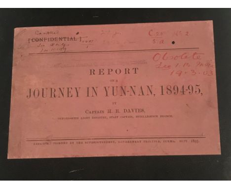
One volume “Report on a journey in Yun-Nan, 1894-95 by Captain H R Davies Oxfordshire Light Infantry Staff Captain Intelligence Branch”, printed by the Superintendent Government Printing Burma September 1895, bearing handwritten inscriptions “Obsolete….. Cancelled, etc.”, stamped to inside “The Property of The Government of India – issued by The Intelligence Branch QMG’s Department, containing maps of country on the scale of 16 miles:1” and elevations of principal roads in Yun-Nan to pocket of cover, bears label to inside of the cloth board cover “Arthur Probsthain Oriental Book Seller 41 Gt Russell Street London WC1”Condition ReportPlease note pen inscriptions to the front label and handwritten notations on Page 45, 46 and 47, 49, 50. There are 5 folded paper maps included in the lot. Map 1 "Map to illustrate Captain Davies' Journey in Yun-Nan", with section cut from lower left corner and discolouration to the centre fold. Map 2 "Map to show main roads from Burma to Yun-Nan", stamped "Intelligence Division 3 Feb 1896", inscribed top right "Chung-King" with hand added annotations / lines with four rips - see images for further detail.Map 3 "Sections and elevations of routes Sheet No. II by Mr. C Jensen Chinese Imperial Telegraph Service", again with some handwritten annotations, some light ripping at creases and handwritten inscription.Map 4 - "Sections and elevations of routes across the Burma-China frontier...", with handwritten titlesMap 5 - "Map to illustrate Captain H R Davies' Report 1894-95", with handwritten annotations and ripping to the creases - see images for further detail.

A rare 19th Century volume containing various letters, documents and cuttings to and from The India Office relating to Tibet, in marbled board binding with tooled and gilded leather spine inscribed “China – Cooper, Baber, Hosie”, including Times cuttings relating to The English Mission to Yarkand, map of the Singpho-Kampti Country or neutral ground between India and China, to illustrated a paper read before the Asiatic Society Benghal, 1st March 1882, by Charles H Lepper, together with reports by Mr Baber on the route followed by Mr. Grovesnor’s Mission between Tali-fu and Momein 1878, with map of the road from Yunnan-fu, another similar report by Mr. Hosie on a journey through central Ssu-ch’uan in June and July 1884 presented to both Houses of Parliament by Command of Her Majesty 1885, etc., etc.

AFTER J RAPKIN "Falkland Islands and Patagonia" a map, visible image 35.5 cm x 25.5 cm, together with AFTER J RAPKIN "East Canada and New Brunswick", coloured engraved map, image size approx 26 cm x 34.5 cm, a copy of "Tombelson's Panoramic Map of The Thames and Medway", two Polar charts and Central chart and another modern copy of a map (7)
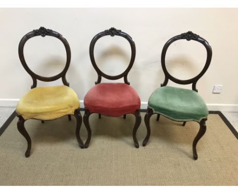
A set of three Victorian mahogany balloon back dining chairs with red, green and yellow velvet upholstered seats respectively, on cabriole legs to scroll decorated feet, an Edwardian mahogany and inlaid oval dressing mirror, a needlework panelled mahogany framed fire screen and a child's bobbin turned chair, bearing ivorine label "Sidney Adams Art Furnisher Bank St., Rugby" , a gilt framed oval mirror and an embroidered vintage map of EnglandCondition ReportCondition report and additional images refer to the 3 chairs only - seats approx 45 cm from the floor. Have had some repairs especially the yellow seated one where the front leg has been off and re-attached. Knocks, bumps, etc throughout the frames. All three need re-seating. Green chair - half of the back has been off and been re-attached. General wear and tear conducive with age and use. See images for further detail.


Books: Pensees Diverses, Ecrites a un Docteur de Sorbonne, A l'occasion de la Comete qui parut au mois de Decembre 1680, par Mr. Bayle, 5th edition, second volume only, published in Amsterdam, Herman Uytwerk 1722, leather bound; Historie Van'TBeghinsel,.......Artsch-Broederschap des H.Roosen-Crans vande Alder_heylighste altijt Maghet ende Moeder Godts Maria.... Published in Ghent, Maximiliaen Graet, 1655, leather bound, other books, including works of Goethe and Schiller and a map of Surrey (qty)

WW2. a 10x8 Black And White photo Showing RAF pilots/Staff discussing a map/raid. The Pilot Taking Charge of discussion is Richard Todd. Photo is signed by Former RAF Pilot Richard Todd. Good Condition. All autographs are genuine hand signed and come with a Certificate of Authenticity. We combine postage on multiple winning lots and can ship worldwide. UK postage from £4.99, EU from £6.99, Rest of World from £8.99
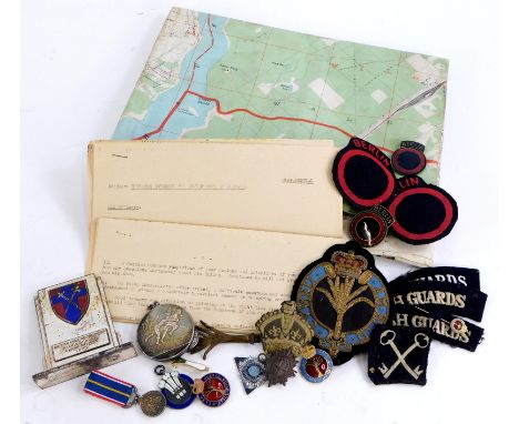
A collection of Welsh Guards military and sporting items, for the British Army, inter Rugby Championships 1952, winners medal awarded to the Second Lieutenant David Howard Davis of the First Battalion the Welsh Guards and an Army Rugby Union medal awarded to the same 1951 to 1952, an enamel fob for the North Wales Centre ACU, a miniature National Service medal from 1939 to 1960, military cloth and other badges, to include Welsh Guards, a map of Berlin, Berlin metal and cloth badges, etc.


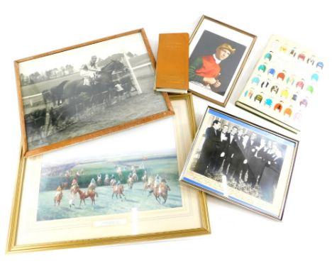
A collection of National Hunt horse racing memorabilia, etc., all relating to the jockey and latterly film stunt rider and trainer Tom Reeves to include a photograph of a farewell dinner to Steve Donoghue inscribed from his brother jockeys Piccadilly Hotel, 20th October 1937, present in the photograph are Tommy Weston, J Herbert, W Sibbert, Charlie Smirke, Steve Donoghue, Bernard Carslake, Michael Beary, Harry Wragg Joe Childs, Fred Fox and Gordon Richards, a photograph dedicated to Norma and Tom Reeves and dated 1988 from Harry Wragg, a black and white photograph, a print, a racecourse goer's map and guide and a Benson Hedges book of racing colours.


A late Victorian mahogany campaign pedestal desk The rectangular moulded top with red and gilt tooled leather inset writing surface above a long frieze map drawer simulated as three drawers; above a kneehole flanked by three short drawers to each side, on turned feet, with brass flush handles, with pencil inscriptions, Pattern 45, No.513, 'Wardroom', 130cm wide, 61cm deep, 78cm high.
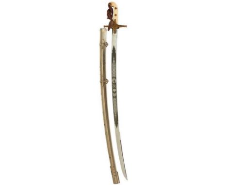
THE SWORDS AND PORTRAIT OF LIEUTENANT GENERAL SIR GEORGE MONTAGUE HARPER KCB DSO HIGHLAND DIVISION, comprising an 1831 Pattern General Officer's sword by DANIELS, 80cm curved clipped back blade etched with scrolling foliage, crowned crossed sword and baton, laurel wreaths, crowned GVR cypher, and maker's panel, retaining good original polish and matt ground, regulation gilt hilt, two-piece ivory grips, one chipped, contained in its plated steel scabbard, some lifting, complete with knot, together with his 1897 Pattern Royal Engineers Officer's sword by ROBERT MOLE, contained in its field service scabbard, a framed and glazed pencil portrait of Harper in service dress titled "France 1916" and signed Leonard Smith, a boxed pair of General Officer's cufflinks and one shoulder insignia, a 9ct gold First War tank tie pin, a 1913 dated half crown engraved with a tank and a bi-plane and 1918, a later? Highland Division sleeve patch and a copy of The History of the Fifty First Division 1914-1918 by Brewsher. (Group) Lieutenant General Sir George Montague Harper (1865-1922) was commissioned as a Lieutenant in the Royal Engineers in 1884, serving at the School of Engineering and promoted Captain while serving in India in 1892. Twice mentioned in Despatches during the Boer War he saw extensive service and rounded the campaign off with the receipt of the Distinguished Service Order. There then followed a number of staff appointments during the inter-war period, before going on to half-pay in 1911. The onset of the First World War saw Harper's appointment to the headquarters of the BEF. Principally his service during the First War was known for his command of the 51st (Highland) Division in France, serving at the Somme, Ancre, Arras, Menin Road and the Tank campaign at Cambrai. Leonard J. Smith (1892-?) was an artist, infantryman, sniper and camouflage designer who also made daring trips in to No Man's Land to map and sketch the German positions.


One volume, ' The Juvenile Travellers ' containing the remarks of a family during a tour of the principle states and kingdoms of Europe by Priscilla Wakefield, 3rd Edition, London 1804, with fold-out map, leather binding together with a quantity of other small 19th Century volumes, most leather bound


Christopher Saxton and John Speed, Norfolk, hand-coloured engraved map with a plan of Norwich, 1631 or later and two smaller maps,comprising a 19th century coloured engraved plan by Thomas Moule, 'University and Town of Cambridge' and a small map of Cheshire (3, framed, Norfolk glazed front and back)


-
109182 item(s)/page