

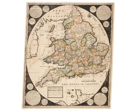
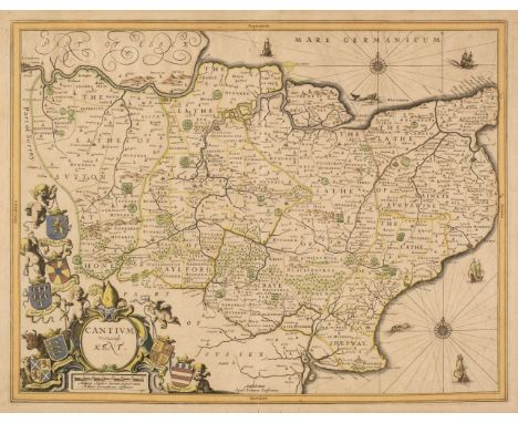
England & Wales. Overton (Henry, publisher), A New & Correct Map of England & Wales now called South Britain, done from the latest surveys and best observations..., 1719, engraved map with contemporary outline colouring with some later enhancement, ornate martial cartouche with a circular advertisement below, the inner vertical margins with columns of text listing cities and market towns, the outer vertical margins decorated with 54 heraldic shields of deaneries and bishoprics and 2 mitres of senior bishops, the printed margins with old folds strengthened and repaired on the verso with the lower horizontal margin replaced with later paper, 580 x 970 mmQty: (1)Footnote: R. W. Shirley. Printed Maps of the British isles, 1650 - 1750, Overton 11, state 1 (of 1). A scarce separately published map, with a striking resemblance to the 1715 map by George Willday.
We found 109182 price guide item(s) matching your search
There are 109182 lots that match your search criteria. Subscribe now to get instant access to the full price guide service.
Click here to subscribe- List
- Grid
-
109182 item(s)/page
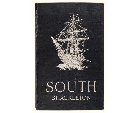
Shackleton (Ernest). South. The Story of Shackleton's Last Expedition 1914-1917, 1st edition, London: William Heinemann, 1919, colour frontispiece,half-tone illustrations, folding map, errata slip tipped-in, some toning to textblock (as usual), small circular ink stamp and shelf number at foot of title, Felixtowe College presentation label from Lord Ailwyn, 1979 to front endpaper, bookplate of 1st Baron Ailwyn (1855-1924, Conservative politician), original cloth, upper cover with illustration of the Endurance blocked in silver, edges slightly rubbed, small label residue to upper cover, 8vo Qty: (1)
England & Wales. Parker (Samuel), A New and Correct Map of England & Wales, Containing all the Cities, Market Towns, Post Towns, Borroughs and whatever places have the Election of members of Parliament &c. circa 1727, engraved map with contemporary outline colouring, laid on later linen, the map set within an oval format surrounded by roundels containing information and statistics, 445 x 365 mmQty: (1)Footnote: R. W. Shirley. Printed Maps of the British Isles, 1650 - 1750, Parker 1. Rare. Only 2 copies are listed on Copac. A separately published map that is occasionally found bound in Willdey Atlases. It is unlikely that Willdey commissioned the maps himself, as they would have contained advertisements for his firm and shop.

England & Wales. Saxton (Christopher & Van den Keere Pieter), Angliae Regnum, circa 1600, engraved map with contemporary outline colouring, table of information in the upper right corner listing cities, bishoprics and castles, central fold cracked and frayed, repaired and strengthened on verso, some oxidization to the old watercolour, some staining and dust soiling to the margins, some professional restoration to the upper right corner, some marginal repairs, 360 x 490 mmQty: (1)Footnote: R. W. Shirley. Early Printed Maps of the British Isles 1477 - 1650, no. 224. state 1. The map was separately published and is based upon Christopher Saxton's general map of England and Wales of 1579. Skelton suggests that the map may have been engraved to accompany the Hans Woutneel / William Smith atlas which was never completed. There are later, amended issues of the map published by Peter Stent and John Overton, but this first state is rare, with few copies ever appearing on the market.

England & Wales. Speed (John), The Kingdome of England, George Humble, circa 1632, hand-coloured carte-a-figures map, engraved by Abraham Goos, eight costumed figures to the vertical margins, inset table of the counties, central fold strengthened and repaired on verso, occasional marginal repaired closed tears, right-hand vertical margin trimmed to the neatline and extended with later paper, lower corners torn with sight loss, but professionally restored in facsimile, 385 x 510 mm, English text on versoQty: (1)Footnote: R. W. Shirley. Early Printed Maps of the British Isles, no. 318.

Estate Plans. Knight Frank & Rutley (Auctioneers), Outlying Portions of the West Dean Estate Sussex, Plan of the Elsted & Treyford Portion, 1911, large colour lithographic plan, laid on linen, some worming, old folds, presented on a wooden batten, 970 x 825 mm, together with Map of an Estate in the Isle of Wight the property of John Fleming Esq, 1817, pen and watercolour estate plan, toned overall some spotting, staining and dust soiling, closed tear affecting the image, 1200 x 755 mm, presented on two later non-matching battens, with Taylor (Isaac). Map of Hampshire..., 1759, but published by The Hampshire Field Club and Archeological Society, 1933, decorative printed wall map, laid on linen on 12 conjoined sheets, slight spotting, 1050 x 1200 mm, presented on two wooden battens, with another 5 British and foreign wall maps, all laid on linen and mounted on wooden battens, various sizes and condition, with Von Sydow (E.). Wand-Atlas..., Gotha bei Justus Perthes, 1851, fifty engraved sheets of Germany, sparse outline colouring, each approximately 300 x 380 mm, and another five assorted maps, various sizes and conditionQty: (approx. 60)
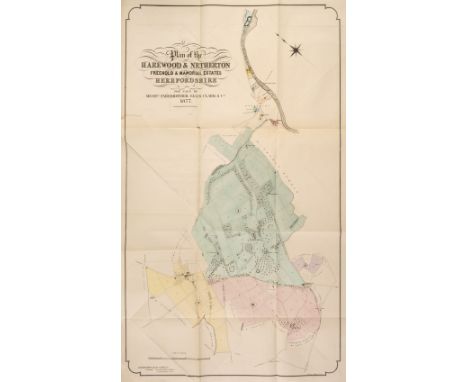
Estate Sale Catalogues. Five estate sale catalogues from Herefordshire, late 19th century & early 20th century, including The Harewood Estates, Auctioned by Farebrother, Ellis, Clark & Co., July 1877, two tint stone lithographs of the main house, large colour lithographic folding map of the whole estate, decorative publisher's paper wrappers with some dust soiling, slim folio, with Holme Lacey, Auctioned by Knight Frank & Rutley, 29th July 1909, frontispiece of a double-page Ordnance Survey map of the area surrounding the property, some creasing and two closed tears affecting the printed image, numerous uncoloured gravures of various properties within the estate, details of acreage, tenants and rent, publisher's paper wrappers, stained, dust soiled and frayed, slim folio, with an additional smaller auction catalogue containing a lithographic folding map of the whole estate, 4to and a separate folder containing two large folding maps of the estate, plus Eaton Bishop, Kingstone & Madley, Auctioned by Messrs. Stooke & Son, 7th June 1905, two large folding colour lithographic maps of the estates, details of acreage, tenants and rent, publisher's printed paper wrappers, slim folio, with another untitled folding estate planQty: (5)
Gloucestershire. Speed (John), Glocestershire contrived into thirty thre severall hundreds & those againe into foure principall devisions. The citie of Glocester & Bristowe discribed with the armes of such noble men as have bene dignified with ye titlles of Earles & Dukes therof, John Sudbury & George Humble [1627], uncoloured engraved map, inset town plans of Gloucester and Bristol, some staining and toning, margins chipped and frayed with slight loss to the printed surface, central fold strengthened and repaired on verso, 380 x 510 mm, together with Greenwood (C. & J.). Map of the County of Gloucester from an Actual Survey made in the year 1823, Jany. 26th 1831, uncoloured engraved map, calligraphic cartouche, compass rose, table of explanation and inset vignette of Gloucester Cathedral, slight creasing and staining, right-hand margin damp stained and frayed with some loss to the printed surface, 610 x 690 mm, with Atkyns (Robert). Glostershire [1712 or later], hand-coloured engraved map, 350 x 410 mm, mounted, plus Collins (H. G. publisher). The British Gazetteer, Glocestershire, [1852 or later], hand-coloured engraved map, old folds, occasional repaired marginal closed tears, slight mount staining, 425 x 350 mm, mountedQty: (4)

Hall (Sidney & Hughes, William, &c.). Black's General Atlas, Edinburgh: Adam and Charles Black, 1846, 57 (of 61) engraved maps with contemporary hand-colouring in outline, some generally light spotting and toning, all edges gilt, contemporary dark green half morocco, worn, front board detached after title, rear board loose, folio, together with an earlier edition of the same, 1844, 58 (of 61) engraved maps with contemporary hand colouring in outline, title partly detached, printed index at rear, variable spotting and dust-soiling, few short splits to folds, some staining to title, endpapers, and a few upper margins, map III-I detached, chipped and edge-frayed, hinges cracked, contemporary black half morocco, heavily worn, front board partly detached, folio Qty: (2)Footnote: Sold as a collection of maps, not subject to return.
![Hampshire. Speed (John), Hantshire described and devided, Thomas Bassett & Richard Chiswell [1676], hand-coloured engrave](https://cdn.globalauctionplatform.com/bdb07c26-397e-4c2f-bdb4-ae5c00ef4cbe/a5699256-544b-4439-9169-ae6000e97c38/468x382.jpg)

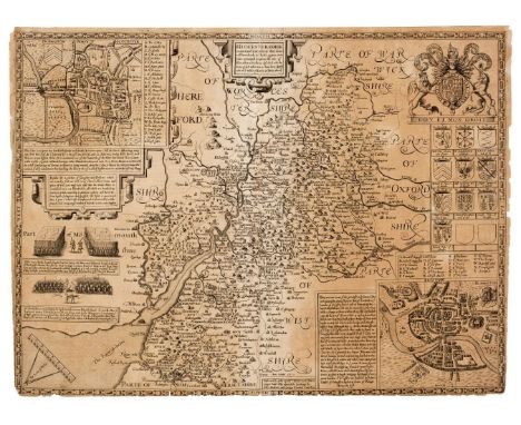
Herefordshire. Saxton (Christopher & Lea Philip), The County of Hereford resurveyed, circa 1683, hand-coloured engraved map, inset town plan of Hereford, slight creasing, 375 x 500 mm, mounted, framed and glazedQty: (1)Footnote: Originally published in 'The Shires of England and Wales described by Christopher Saxton'.
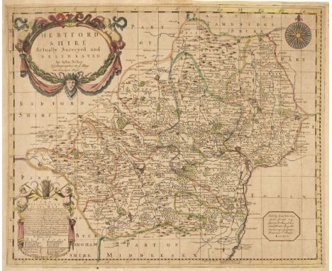
Hertfordshire. Seller (John), Hertfordshire Actually Surveyed and Delineated, Sold by G. Willdey at the Great Toy Spectacle, China Ware and Print Shop..., circa 1732, hand-coloured engraved map, large decorative title cartouche, compass rose and ornate table of explanation, torn with slight loss to the upper strapwork margin, replace in facsimile, slight marginal staining, toned overall, 420 x 500 mmQty: (1)Footnote: Uncommon.

Holy Land. Fuller (Thomas), Four regional maps, Jerusalem qualis (vt plurimum) extitit aetate Solomonis, Libanus et ejus Vicinia, Lectori en Tibi Antiquam Canaan (Qualis Tempore Abrahae, et Ante Adventum Jushuae Extitit) in Tredecim Nationes Divisam [and] An untitled map of the Tribes of Israel, circa 1650, together 4 uncoloured engraved maps, slight staining, each approximately 285 x 375 mmQty: (4)Footnote: Eran Laor. Maps of the Holy Land. Numbers 1024, 279, 280 & 289. Originally published in Thomas Fuller's "A Pisgah-Sight of Palestine".
![Hong Kong and the Far East. Four military issue maps, Hong King, Canton, Singapore [and] Hainan, U. S. Army Map Service Depar](https://cdn.globalauctionplatform.com/bdb07c26-397e-4c2f-bdb4-ae5c00ef4cbe/80ff1a27-1dff-4d45-bca9-ae6000e97f9b/468x382.jpg)
Hong Kong and the Far East. Four military issue maps, Hong King, Canton, Singapore [and] Hainan, U. S. Army Map Service Department, circa 1944, together four colour photolithographic maps, some dust soiling and staining, old folds, the map of Hong Kong worn with slight loss along old folds, each approximately 610 x 790 mmQty: (4)

Hungary. Speed (John), The Mape of Hungari newly augmented by John Speede Ano Dom. 1626, Thomas Bassett & Richard Chiswell [1676], hand-coloured engraved map, hand-coloured engraved carte-a-figures map, eight costumed figures to the vertical margins and four oval vignettes of principal cities along the upper margin, 395 x 520 mm, English text on versoQty: (1)

India. Jefferys (Thomas), The East Indies with the Roads, 2nd edition, To the Directors of the Honble. East India Company Thos. Jefferys Humbly dedicates this Map, 1768, large engraved map with contemporary outline colouring, printed on four sheets, partially conjoined and presented on three sheets, the upper margin on the two lower sheets frayed and slightly stained, overall size if joined approximately 1010 x 1350 mmQty: (3)

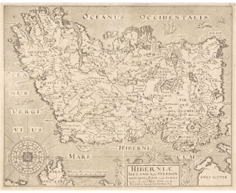
Ireland. Hole (G.), Hiberniae, Ireland Anglis Yverdon Britannis Erin..., 1610, uncoloured engraved map orientated to the west, strapwork cartouche and ornate compass rose, printer's fold, slight toning, 270 x 340 mm, together with Morden (Robert). The Kingdom of Ireland [1695 or later], hand-coloured engraved map, slight spotting and slight marginal tape staining, 410 x 350 mm, with another uncoloured example similar, plus Gall & Inglis (publishers). Gall & Inglis' Map of Ireland with the Railways, Edinburgh, circa 1850, coloured lithographic map, slight mount staining, 540 x 440 mm, and Seale (R. W.). A New and Accurate map of parts of England, Scotland & Ireland bordering on St. George's Channel, J. Hinton, circa 1780, hand-coloured engraved map, old folds, backed with archival tissue, 365 x 270 mmQty: (5)

![Isle of Man. Speed (John), The Isle of Man exactly described and into Several Parishes divided..., Roger Rea [1662], hand-col](https://cdn.globalauctionplatform.com/bdb07c26-397e-4c2f-bdb4-ae5c00ef4cbe/e341c559-7031-4957-80f4-ae6000e983fa/468x382.jpg)
Isle of Man. Speed (John), The Isle of Man exactly described and into Several Parishes divided..., Roger Rea [1662], hand-coloured engraved map, large strapwork cartouche and mileage scales to the vertical margins, large margins, one pinhole to the image, 380 x 505 mm, English text on versoQty: (1)
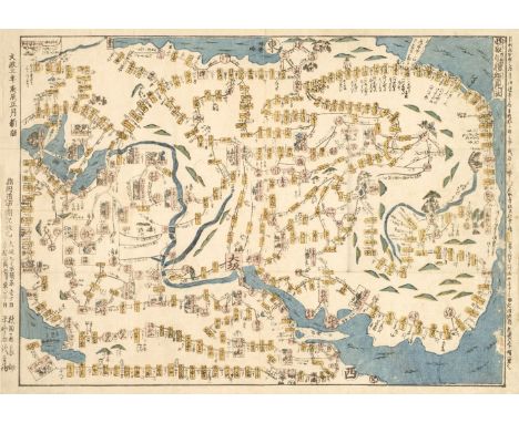
Japan. ??????? Saigoku junrei saiken zu, Saigoku Pilgrimage Map, circa 1820, colour printed woodblock map, old folds, contemporary card wrappers with title label, slight worming to the lower right corner, 320 x 445 mm Qty: (1)Footnote: A rare map of the Kansai region of Japan, that shows the 33 Buddhist temples that a follower must visit to complete the pilgrimage. Pilgrims traditionally wore white robes and carried a walking stick. Traditionally completed on foot, it is today, more commonly achieved in a car or on trains. Pilgrims record their progress with a prayer book, which the temple staff mark with red stamps and Japanese calligraphy indicating the temple number, the temple name, and the specific name of the Kannon image. Some pilgrims receive the stamps on their white coats as well and these are then stored and used as a shroud when the devotee is cremated.

Johnston (Alexander Keith). The Royal Atlas of Modern Geography, ...with additions and corrections to the present date by T.B. Johnston, new edition, Edinburgh and London: W. & A.K. Johnston, 1884, title and dedication, 44 (of 50) double-page engraved maps, with colour printing and contemporary hand-colouring in outline, some spotting (mainly to letterpress and upper blank margins), a few maps with short split to fold, half-title with fore-edge partly excised, first few leaves edge-frayed and somewhat chipped, map 29 with minor marks, map 44 lightly toned, stitching broken and several leaves detached, all edges gilt, contemporary half red sheep gilt, worn and stained, boards detached, lower third of spine missing, folio, together with: Betts (John, publisher), The London Modern Atlas, circa 1846, 16 (of 27) double-page engraved maps, with contemporary hand-colouring, some light offsetting and dust-soiling, most with short splits to folds, contents leaf detached and frayed, front hinge cracked, contemporary cloth-backed boards, printed paper label to front board, rubbed, extremities worn, front joint split, small slim folio, plus: Le Sage (A.), Atlas Historique, Généalogique, Chronologique, et Géographique, [Paris]: P. Didot l'Aine?, 1814, title and contents leaf, 33 double-page (and one half-page) engraved tables (complete as list), with contemporary hand-colouring, including 17 with engraved maps, scarce minor spots or toning, an additional engraved large folding table: Le Cours des Tems ou Tableau de Histoire Universelle, with contemporary hand-colouring, dated 1818 at foot, some edge-fraying and a couple of closed tears, front hinge cracked, contemporary half mottled calf, front board with shield-shaped gilt-lettered and decorated leather label, faded and worn, lacking spine, atlas folio, with three other atlases: The Harrow Atlas of Modern Geography, 1868; Black's General Atlas of the World, 1859; The Chambers of Commerce Atlas, 1925, various conditions and sizesQty: (6)Footnote: Sold as a collection of maps, not subject to return.


Leicestershire. Speed (John), Leicester both Countye and Citie described, The Honorable Famylies that have had the titles of Earls thereof. With other accidents therein observed, John Sudbury & George Humble,1st edition [1611], uncoloured engraved map, an inset town plan of Leicester, large margins, slight toning along the central fold, 385 x 510 mm, English text on versoQty: (1)

Lewis (Samuel). Atlas to the Topographical Dictionary of England and Wales, 1848, folding map of England and Wales and Yorkshire and 49 (only) engraved English and Welsh county maps, lacking Isle of Man, Suffolk and Rutland, all with contemporary outline colouring, some folding, plus an uncoloured folding plan of London, slight spotting throughout, occasional offsetting, contemporary cloth, boards detached and partially lacking spine, 4to, together with another copy similar containing the folding maps of England & Wales, Yorkshire and London and 49 (only) engraved English and Welsh county maps, some folding, all with contemporary outline colouring, lacking Devon, Dorset, Isle of Man, Hampshire and Staffordshire, some offsetting, slight spotting, rear board detached, lacking upper board and spine, 4toQty: (2)Footnote: Sold as a collection of maps, not subject to return.
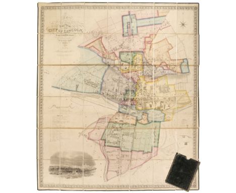
Lincoln. Padley (James Sandby), To Sir Edward French Bromhead Bart. This Map of the City of Lincoln is most respectfully Dedicated...,1842, new edition corrected to 1868, large engraved map with contemporary outline colouring, sectionalised and laid on linen, calligraphic title, table of reference, list of parishes, compass rose and an uncoloured vignette of the 'South View of the City of Lincoln', edged in green silk, marbled endpapers, contained in a contemporary morocco slipcase with gilt lettering to spine, corners bumped and frayed, 1200 x 1030 mmQty: (1)

Lithuania. Mercator (Gerard & Hondius Jodocus), Lithuania, circa 1630, engraved map with contemporary outline colouring, 375 x 435 mm, mounted, framed and glazed, together with Jansson (Jan). Lithuania, Amsterdam, circa 1628, hand-coloured engraved map originally published in the 'Atlas Minor', 150 x 200 mm, Latin text on verso, with Van den Keere (Pieter). Lithuania, Jodicus Hondius & Johannes Cloppenburg, Amsterdam, circa 1632, uncoloured engraved map, 190 x 250 mm, Latin text on verso, plus Mercator (Gerard & Hondius Henricus). Lithuania, Amsterdam, circa 1610, uncoloured engraved map, 140 x 180 mm, French text on versoQty: (4)

London. Cary (John), Cary's New and Accurate Plan of London and Westminster, the Borough of Southwark and parts adjacent: viz. Kensington, Chelsea, Islington, Hackney, Walworth, Newington &c with an Alphabetical list of upwards of 500 of the most principal streets with references to their situation, 1806,engraved map, sectionalised and laid on linen, contemporary outline colouring, with a list of over 500 of the principal streets, contained in a contemporary marbled card slipcase with printed label to upper board, rubbed at extremities, 815 x 1245 mmQty: (1)Footnote: James Howego. The Printed Maps of London, no.184, state 9 (of 20).

London. Coltman (N.), A New Survey of the Environs of London, Extending Twenty Miles North & South from the Parallel of St. Pauls..., published Whittle (James & Laurie Richard Holmes), 1st March 1828, engraved map with contemporary outline colouring, sectionalised and laid on linen, slight spotting, some dust soiling, 555 x 690 mm, marbled endpapers contained in the publisher's marbled card slipcase with printed label to the upper cover, slipcase worn and frayedQty: (1)Footnote: James Howgego. Printed Maps of London 1553 - 1850, no 241a. This state not recorded.
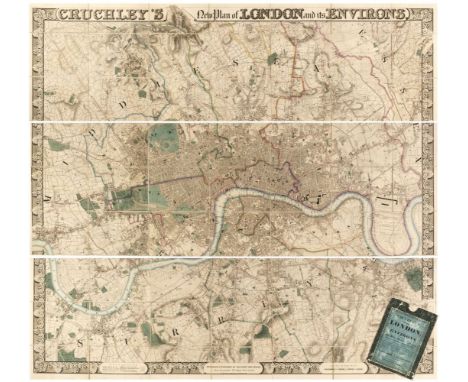
London. Cruchley (George Frederick). Cruchley's New Plan of London and its Environs, Engraved and Published by Cruchley, Map - Seller (from Arrowsmith's) 38 Ludgate Street, London (A New Edition Improved to the Present Time), [1835], large engraved map with contemporary outline colouring, sectionalised and laid on linen, on three sheets, decorative strapwork margins with the title above the map and a scale of references, publication details and a mileage scale incorporated into the lower horizontal margin, very slight offsetting, marbled endpapers with a printed notice to one, giving the boundary circle for the two-penny post, 1180 x 1350 mm, contained in a contemporary green marbled card slipcase with printed title label to the upper cover, worn at extremitiesQty: (1)Footnote: James Howgego. Printed Maps of London, number 317a, state 5. An impressive large scale map of London with bright contemporary colouring. Uncommon.

London. Mogg (Edward), London in Miniature with the Surrounding Villages, An entire new plan..., 1823, engraved map with contemporary outline colouring, slight staining, 515 x 940 mm, contained in a contemporary marbled card slipcase with printed label to upper cover, case heavily worn and frayedQty: (1)Footnote: J. Howgego, Printed Maps of London, number 237, State 14.

London. Wyld (James, publisher), A New Map of the Country Twenty-five Miles round London, circa 1860. engraved map with bright contemporary hand colouring, sectionalised and laid on linen, 1040 x 1300 mm, marbled endpapers, together with Stanford (Edward, publisher). A Map of the Environs of London Extending Twenty-Five Miles fr. the Metropolis, circa 1870, lithographic map with contemporary outline colouring, sectionalised and laid on linen, short split along one fold, contemporary cloth boards, but lacking rear board and spine, 890 x 940 mmQty: (2)

Middle East and the Holy Land. Homann (Johann Baptiste), Aegyptus Hodierna..., Nuremberg, circa 1720, engraved map with contemporary hand colouring, uncoloured engraved scenes of cataracts, pyramids and antiquities, 580 x 490 mm, framed and glazed, together with Mariette (Pierre). Natolia quae olim Asia Minor, Paris, circa 1658, engraved map with sparse contemporary outline colouring, based upon an earlier map by W. Blaeu, 375 x 490 mm, framed and glazed, with Lopez (Tómas Máuricio). Mapa geográfico de Siria y tierras adyacentes, Madrid, 1799, engraved map with contemporary outline colouring, old folds, 305 x 365 mm, framed and glazedQty: (3)

Monin (Charles V.). Atlas Classique de la Geographie Ancienne, du Moyen Age, et Moderne, a l'Usage des Colleges et des Pensions, nouvelle edition, Paris: Jacques Lecoffre, circa 1845, folding engraved comparison table (closed edge tear, affecting border), 34 (0f 40) engraved maps and charts, with contemporary hand-colouring in outline, scarce minor spotting (mainly at front), stitching a little strained, front pastedown with presentation bookplate, contemporary brown quarter morocco, printed paper label to front board, heavily worn, both boards detached, 4to, together with: Cellarius (Christopher), Geographia Antiqua: being a Complete Set of Maps of Antient Geography; beautifully engraved from Cellarius, Dublin: William Watson, 1814, 31 (of 33) engraved maps, one with some later hand-colouring in outline, generally dust-soiled, some staining, creasing and edge-fraying, one map margin with loss to lower blank corner, title with early ink mansucript ownership names, disbound in original sheep-backed wrappers, worn, soiled and stained, spine lacking, oblong 4toQty: (2)Footnote: Sold as a collection of maps, not subject to return.
![Northamptonshire. Smith (William). Northamptoniae Comitatus Descriptio..., John Overton [1675 or later], engraved map with co](https://cdn.globalauctionplatform.com/bdb07c26-397e-4c2f-bdb4-ae5c00ef4cbe/bed86715-7b00-408f-b48f-ae6000e99451/468x382.jpg)
Northamptonshire. Smith (William). Northamptoniae Comitatus Descriptio..., John Overton [1675 or later], engraved map with contemporary outline colouring, slight fraying to the margins. lower horizontal margin extended, 365 x 480 mm, together with, Valk (G. & Schenk P.). Comitatus Northantonensis vernacule Northampton Shire, circa 1720, engraved map with contemporary outline colouring, some oxidization to old watercolour causing slight cracking and splitting, 385 x 500 mmQty: (2)
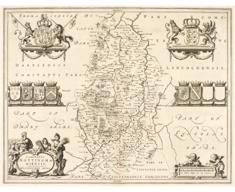
Nottinghamshire. Blaeu (Johannes), Comitatus Nottinghamiensis, Nottingham-shire, Amsterdam, circa 1650, uncoloured engraved map, decorative cartouche and mileage scale, 385 x 500 mm, French text on verso, together with Schenk (P. & Valk G.). Comitatus Nottinghamiensis sive Nottingham-shire, Amsterdam, circa 1700, engraved map with contemporary outline colouring, decorative cartouche and mileage scale, slight offsetting, 375 x 470 mm, with Saxton (Christopher & Kip W.). Notingamiae Comitatus olim pars Coritanorum, [1637], uncoloured engraved map, large strapwork cartouche and mileage scale, 260 x 315 mm, plus Simmons (Matthew). Nottingha. Shire, [1657 or later], uncoloured map engraved by Jacob Van Langeren, the map displayed beneath a triangular mileage table, overall size 105 x 100 mmQty: (4)


Ogilby (John). The Road from London to Buckingham continued to Banbury in com. Oxon. circa 1676, hand-coloured engraved strip road map, 340 x 440 mm, mounted, framed and glazed, together with The Road from Dartmouth in Com. Devon to Minhead in com. Somerset, circa 1676, hand-coloured strip road map, slight overall toning, 325 x 440 mm, mounted, framed and glazedQty: (2)Footnote: The first map commences in London and passes through Acton, Uxbridge, Amersham, Wendover, Alesbury and Buckingham and ends at Banbury. Sheet number 12. The second map commences at Dartmouth and passes through Exeter, Silverton, Tiverton and Bampton and ends at Minehead, sheet number 65.

Oxfordshire. Speed (John), Oxfordshire described with ye Citie and the Armes of the Colledges of that famous University, C. Dicey & Co. circa 1770, hand-coloured engraved map, inset town plan of Oxford, the vertical margins decorated with 18 heraldic shields, additional horizontal and vertical folds with some restoration, slight creasing and staining, trimmed to the neatline and laid on near-contemporary paper, 385 x 530 mm, mountedQty: (1)Footnote: The last and one of the scarcest editions of John Speed's maps.

Pembroke. Saxton (Christopher & Lea Philip), Pembrockshire Discribed by C. S. Corrected and Amended with many additions by P. Lea [1693], hand-coloured engraved map, inset town plans of Pembroke and Haverfordwest, 355 x 465 mm, mounted, framed and glazedQty: (1)Footnote: Originally published in "The Shires of England and Wales".

Poland. De Cassini (G. B.), Provincia Poloniae cum Confinys, 1712, hand-coloured engraved map, 225 x 330 mm, supplied with a sheet of descriptive text set in a floriate border, 225 x 330 mm, together with Walch (Johann). Polen nach seiner ersten und lezten oder gaenzlichen Theilung, Augusburg, 1796, engraved map with contemporary outline colouring, 490 x 590 mm, with Von Reilly (Franz Johann Joseph). Karte von Polen nach dem Petersburger Theilungs - Traktatee von 24th October und dem Russich Kaiserlichen manifeste von 25th December 1795..., Vienna, 1796, engraved map with contemporary outline colouring, 590 x 720 mm with another copy similar, plus Kitchin (Thomas). Carte de la Pologne, circa 1786, uncoloured engraved map, old folds, slight wear to old folds, repaired on verso, very slight toning, 400 x 495 mm, and Johnston (Andrew). Poland and Lithuania, D. Lizars, Edinburgh, circa 1840, engraved map with contemporary hand-colouring, 400 x 500 mm, with Brion de la Tour (Louis). Etats de Pologne et Lithuanie divisés par Palatinats et provinces Ecclésiastiques..., 1786, hand-coloured engraved map, trimmed to the foliate margins along the horizontal borders, 275 x 320 mmQty: (7)
![Poland. Ortelius (Abraham), Poloniae Finitimarumque Locorum Descriptio Auctore Wenceslao Godreccio Polono [1570 or later], un](https://cdn.globalauctionplatform.com/bdb07c26-397e-4c2f-bdb4-ae5c00ef4cbe/6aa3f3d3-553e-433c-8ebb-ae6000e99a66/468x382.jpg)

Poland. Petrini (Paolo), Stati Della Corona Di Polonia Divisa nele sue Principali Provincie e Palatinati..., Naples, circa 1700, engraved map with contemporary hand-colouring and some later enhancement, 430 x 550 mmQty: (1)Footnote: An uncommon map of Poland. Petrini's maps are typically based upon the work of Nicolas Sanson, although this example credits Nicolas's son, Guillaume Sanson.

Prussia. Van der Aa (Pieter), La Prusse suivant les Nouvelles Observations..., Leiden, circa 1714, hand-coloured engraved map, with a printed 'picture frame' border, mounted in a triple-aperture mount with two other examples, one uncoloured and one slightly later state without the picture frame border, two maps trimmed to the neatline of the upper margin, 265 x 385 mm, framed and glazed, together with Bonne (Rigobert). Royaume de Prusse, circa 1785, two hand-coloured engraved maps, displayed in a double-aperture mount, each approximately 235 x 345 mm, framed and glazed, with another six maps of Prussia, with examples by or after Munster, De L'Isle, Ortelius/Coignet, Kitchin, Walch and Munster/Solinus, small format, good condition, the Munster/Solinus framed and glazedQty: (9)
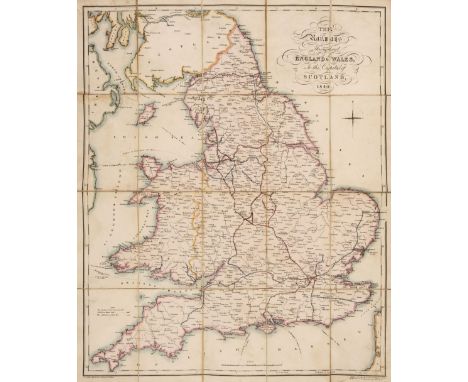
Railway Maps. The Railways throughout England & Wales, to the capital of Scotland, London: H. Tuck, 1840, lithographic map with contemporary hand-colouring, sectionalised and laid on linen, calligraphic title, some staining, verso to one section with adhered printed publisher's advertisement, 573 x 476 mm, inside upper board with printed Railway Compendium, bound in original cloth (soiled with some wear), printed label to upper board, with calligraphic title and steam engine vignette, somewhat soiled and rubbed, with ink manuscript date added, together with: Cheffins's Map of the English & Scotch Railways, London: C.F. Cheffins, 1848, lithographic map with contemporary outline colouring, sectionalised and laid on linen, inset map of the principal railways in Scotland, folding Cornwall extension, some discolouration and soiling, 708 x 580 mm, bound in original blind-stamped and gilt-lettered cloth, soiled and somewhat rubbed, plus: Wyld's Road Director, through England and Wales, London: James Wyld, 1857, engraved map with contemporary outline colouring, sectionalised and laid on linen, a trifle dust-soiled with some minor marks, slight wear where folds cross, 637 x 577 mm, without slipcase, and two others similar: Black's Road & Railway Travelling Map of England [cover-title], London: A. & C. Black, circa 1870; A Map of England & Wales ... shewing the principal roads, railways, rivers and canals, London: S. Lewis & Co., 1839, two parts only (of 4), various sizes and conditionQty: (6)

Russia. De Vaugondy (Gilles Robert), Partie Occidentale de l'Empire de Russie, où se Trouve Distinguée la Russie Europeenne..., Paris, 1750, engraved map with contemporary outline colouring, 475 x 590 mm, mounted, framed and glazed, together with Bowen (Emanuel). A New and Accurate Map of the Whole Russian Empire and contain'd both in Europe and Asia..., circa 1747, hand-coloured engraved map, 350 x 465 mm, mounted, framed and glazedQty: (2)
![Scotland. Ortelius (Abraham), Scotiae Tabula, [1573 or later], engraved map with contemporary hand-colouring, orientated to t](https://cdn.globalauctionplatform.com/bdb07c26-397e-4c2f-bdb4-ae5c00ef4cbe/53bd6384-df48-4da7-93ea-ae6000e99eaa/468x382.jpg)

Sheffield. Fairbank (W. & J.), A Map of the Town and Environs of Sheffield, 1808, large uncoloured engraved map, some spotting and dust soiling, slight creasing and lightly toned, two long repaired tears affecting the printed image, slight marginal fraying, laid on canvas, 1025 x 860 mmQty: (1)Footnote: Rare. Copac records only three institutional copies.
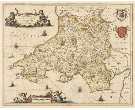
South Wales. Jansson (Jan), Principatus Walliae pars Australis vulgo South-Wales, 1646, engraved map with contemporary outline colouring, decorative cartouche and mileage scale, compass rose and numerous rhumb lines, slight offsetting, 415 x 520 mm French text on verso, together with Blome (Richard). A Generall Map of South Wales wherein are the Countyes of Glamorgan, Carmarden, Pembrock, Cardigan, Brecknock, Radnor [1673], hand-coloured engraved map, old folds, slight fraying to the margins, one repaired closed tear affecting the printed surface, 345 x 460 mm, with Schenk (P. & Valk G.). Principatus Walliae pars Australis vulgo South-Wales, Amsterdam, circa 1715, engraved map with contemporary outline colouring, occasional wormholes, slight spotting to the margins, 410 x 510 mm, plus Bowen (Emanuel). A New and Accurate Map of South Wales, containing the Counties of Pembroke, Carmarthen, Cardigan, Glamorgan, Brecknock & Radnor..., Carington Bowles, [1729 or later], two engraved sheets (only of six showing parts of Pembroke and Cardiganshire), both with contemporary outline colouring, some professional marginal restoration, each approximately 595 x 480 mm, and Walker (J. & A.). Map of South Wales drawn from Trionometrical Surveys, 1833, large engraved map with contemporary outline colouring, sectionalised and laid on linen, 630 x 785 mm, marbled endpapers with publisher's printed title label to one cover, with Morden (Robert). South Wales [1695 or later], uncoloured engraved map, 360 x 430 mmQty: (7)
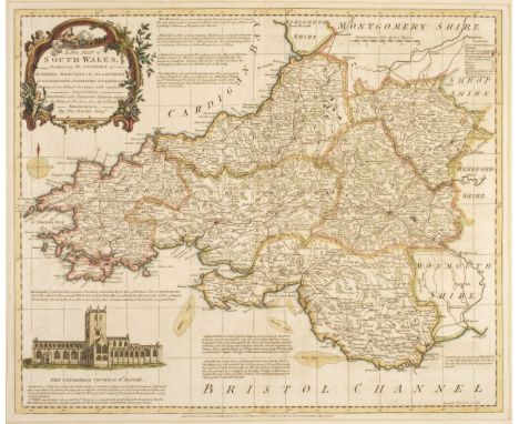
South Wales. Kitchin (Thomas), A New Map of South Wales, containing the Counties of Radnor, Brecknock, Glamorgan, Carmarthen, Pembroke & Cardigan..., Laurie & Whittle, Robt. Wilkinson and Bowles & Carver, 1762, engraved map with contemporary outline colouring and some later enhancement, vignette view of St. David's Cathedral, slight mount staining, 425 x 510 mm, with Jansson (Jan). Principatus Walliae pars Australis vulgo South Wales, Amsterdam, circa 1660, engraved map with contemporary outline colouring, 410 x 515 mm, no text on verso, together with Darton (W. & Son, publishers). A New Map of South Wales divided into its six Counties or Shires and the Parliamentary Divisions, circa 1835, engraved map with contemporary outline colouring, inset vignette view of Swansea, slight staining, old folds, some repair and strengthening to the old folds on verso, 545 x 690 mm, with Morden (Robert). South Wales [1695], uncoloured engraved map, 360 x 430 mm, with another 22 engraved and lithographic maps of South Wales, including examples by or after Arrowsmith, J & C Walker, Bartholomew, Cary, Duncan, Cassell, Collins, Iliffe & Son, Mason & Payne, Johnston, Teesdale, Roscoe, George Philip and Morden, occasional duplicates, various sizes and conditionQty: (26)


South West England. Mercator (Gerard), Cornubia, Devonia, Somersetus, Dorcestria, Wiltonia, Glocestria, Monumetha, Glamorgan, Caermarden, Penbrok, Cardigan, Radnor, Breknoke, Herefordia & Wigornia, [1595 or later], hand-coloured engraved map, large strapwork cartouche, slight offsetting, 370 x 470 mm, French text on verso, together with Sanson (Nicolas). Provinces d'West, autrefois Royaume d'Westsex, ou sont Aujourdhuy les Comtés Hant-Shire, l'Isle de Wight, Barck-Sh., Wilt-Sh., Dorcet-Sh., Somerset-Sh., Devonish et Cornwall &c...., Paris, 1654, uncoloured engraved map, large strapwork cartouche, 370 x 530 mm, with Collins (Captain Greenville). Plymouth [and] The Severn or Channel of Bristol, circa 1690, two hand-coloured engraved sea charts, slight creasing to the Bristol Channel, each approximately 450 x 570 mmQty: (4)
Spain. Speed (John), Spaine Newly described with many adictions both in the attires of the people & the Setuations of their Cheifest Cities by John Sped 1626, George Humble [1627], hand-coloured carte-a-figures map with 10 vignettes of costumed figures to the vertical margins and 9 oval vignettes along the upper margin of principal cities, trimmed to the neatline along the upper margin, some marginal fraying and short closed tears, dust-stained and toned overall, slight offsetting and water staining, short split at the base of the central fold, 410 x 535 mm, English text on verso, together with Mercator (Gerard & Hondius H.). Andaluzia continens Sevillam et Cordubam, circa 1640, engraved map with contemporary outline colouring, slight marginal fraying but not affecting the printed image, 355 x 500 mm, no text on verso, with De Vaugondy (Gilles Robert). Partie Meridionale des Etats de Castille..., Paris, 1751, engraved map with contemporary outline colouring, slight staining to the central fold, short split at the base of the central fold, 485 x 565 mm, with two other large scale maps of Spain by Arrowsmith and Swanston, various conditionQty: (5)

Spain. Speed (John). Spaine Newly described with many adictions both in the attires of the people & the Setuations of their Cheifest Cities by John Sped 1626, Thomas Bassett & Richard Chiswell [1676], hand-coloured carte-a-figures map with 10 vignettes of costumed figures to the vertical margins and 9 oval vignettes along the upper margin of principal cities, some creasing, central fold partially strengthened on verso, 420 x 535 mm, English text on versoQty: (1)

St. Petersburg. Homann (Johann Baptist), Topographische Vorstellung der Neuen Russischen Haupt-Residenz und See-Stadt St. Petersburg samt ihrer zu Erst Aufgerichten Vestug..., Nuremberg, circa 1720, engraved city plan with contemporary hand-colouring, large uncoloured allegorical cartouche, inset map of the River Neva, circular vignette of a view of Kronstadt Castle.500 x 590 mm, framed and glazed, Qty: (1)
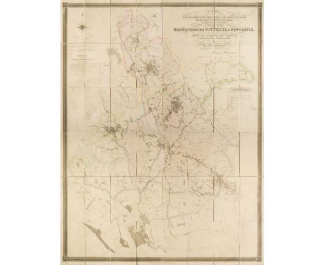
The Potteries. Hargreaves (Thomas), To the Most Noble George Granville, Marquess of Stafford K. G. &c. &c. The Zealous Promoter of the Interests of the Several Towns and Liberal Patron of their Public Institutions, This Map of the Staffordshire Potteries & Newcastle, Including their Vicinities, Shewing the Limits of the Boroughs, Parishes, Townships, etc., Engraved from a Minute Trigonometrical Survey, is with permission dedicated..., Burslem, 1st May 1832, large engraved map with contemporary outline colouring, sectionalised and laid on linen, calligraphic title cartouche, table of explanation and compass rose, slight staining, marbled endpapers, 1580 x 1220 mmQty: (1)


Wales. Dodd (J.J.), Dame Venodotia Alias Modryb Gwen; A Map of North Wales, published H.Humphreys, Carnarvon, circa 1850, allegorical uncoloured lithographic map after H. Hughes showing North Wales as an old woman with a sack on her back, key plate below image, slight spotting, 315 x 255 mm, together with Harvey (William, pseud. Aleph). Wales, 1869, colour lithographic allegorical map of Wales depicting Owen Glendwr, originally published in "Geographical Fun", four lines of rhyming text below the image, 265 x 210 mm, mounted, framed and glazed, with Tennant (Lillian Lancaster). Wales, [Adam & Charles Black, 1912], colour photolithographic allegorical map composed of figures from Welsh mythology, dominated by an image of King Edward presenting the first Prince of Wales to the people, 200 x 150 mm, mounted, framed and glazedQty: (3)
-
109182 item(s)/page