We found 109198 price guide item(s) matching your search
There are 109198 lots that match your search criteria. Subscribe now to get instant access to the full price guide service.
Click here to subscribe- List
- Grid
-
109198 item(s)/page


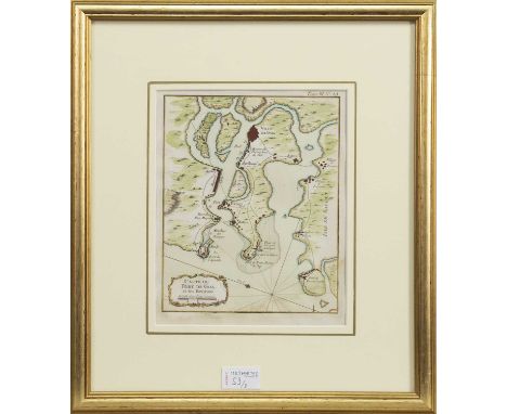
![MID-18TH CENTURY MAP BY M. BRION,L'Ecosse [...], hand-coloured, pub. S. Desnos, Paris circa 1766, image size 22.5cm x 26cm, f](https://cdn.globalauctionplatform.com/4f04e8cc-cc0f-479f-ba45-af2500be9141/d48f58ac-ac73-4108-8cf3-af9000c358c8/468x382.jpg)


Lot 26
COMIC MAP OF EUROPE, LATE 19TH CENTURY CARICATURE MAP,based upon Paul Hadol's popular prototype of 1870, hand-coloured lithograph, approx. 28cm x 42cm, mounted, framed and under glassThe map itself appears generally good. Foxing above the OF, and same position to bottom edge. Some other minor areas to edge, and yellowing of paper but generally good for age. Frame worn and would benefit from reframing. Additional images now available.


Lot 52
FOUR ENGLISH COUNTY MAPS, BOWEN (THOMAS),circa 1780, comprising Essex, Oxforshire, Shropshire and Yorkshire, each hand-coloured, mounted, framed and under glass, the largest Yorkshire at 37cm x 48cm overall, along with a map of Lancashire, pub. Fullarton of Glasgow, circa 1840s, and London by Edward Weller, circa mid-19th century, both also framed (6)


Lot 9080
Jodocus Hondius (Dutch/Flemish 1594-1629) & Hendrik Hondius (Dutch/Flemish 1597-1651): Carte du Pais de Xaintonge (Western France), engraved map with hand colouring pub. c1650 Amsterdam, with 'Description of the Country of Xaintoigne' book plate verso together with 19th century map of Gironde max 38cm x 50cm (2)


Lot 121
MACGILLIVRAY (JOHN)Narrative of the Voyage of H.M.S. Rattlesnake, 2 vol., FIRST EDITION, 13 lithographed plates, one folding map with a small tear, woodcut illustrations throughout, with publisher's advertisements, spotting mostly to plates and to first and last leaves of both volumes, publisher's dark blue cloth, spines faded, hinges soft, some wear to covers, corners bumped, 8vo, T.W. Boone, 1852 (2)Footnotes:Provenance: Meldon Park, bookplate.This lot is subject to the following lot symbols: •• Zero rated for VAT, no VAT will be added to the Hammer Price or the Buyer's Premium.For further information on this lot please visit Bonhams.com

Lot 124
SCARLETT (PETER CAMPBELL)South America and the Pacific, FIRST EDITION, 2 vol., 2 lithographed frontispieces and 3 lithographed plates, 4 engraved folding maps, folding letterpress table, spotting and occasional offsetting, hinges starting, half calf gilt, minor wear, 8vo, Henry Colburn, 1838--MUNDY (GODFREY CHARLES) Pen and Pencil Sketches, being the Journal of a Tour in India, 2 vol., 2 engraved frontispieces plus 14 plates, one folding engraved map with routes supplied in red and blue, woodcut illustrations in the text, spotting and offsetting throughout, half calf gilt, spines sunned, 8vo, John Murray, 1832-- LEWIS (MATTHEW GREGORY) Journal of a West India Proprietor, kept during a residence in the Island of Jamaica, 2 vol., FIRST EDITION, with half-title, half-calf gilt, minor wear, spines sunned, 8vo, John Murray, 1834; and 4 others (10)Footnotes:Provenance: Meldon Park, bookplates.This lot is subject to the following lot symbols: •• Zero rated for VAT, no VAT will be added to the Hammer Price or the Buyer's Premium.For further information on this lot please visit Bonhams.com

Lot 129
SURTEES (ROBERT)The History and Antiquities of the County Palatine of Durham; compiled from the original records, preserved in public repositories and private collections, 4 vol., FIRST EDITION, engraved plates and portraits, occasional foxing, contemporary half calf, spines gilt with black morocco labels, Nichols, Son and Bentley, 1816-1840--RAINE (JAMS) North Durham, in 2 original parts (as issued?), map and engraved plates (a couple damp-stained), publisher's printed cloth-backed wrappers, worn and stained, spines defective, one corner chipped, J.B. Nichols, 1830, folio (6)This lot is subject to the following lot symbols: •• Zero rated for VAT, no VAT will be added to the Hammer Price or the Buyer's Premium.For further information on this lot please visit Bonhams.com

Lot 136
NORTHUMBERLANDMACKENZIE (E.) Historical, Topographical & Descriptive View of the County of Northumberland, 2 vol., engraved folding map (torn without loss) and plates, some foxing, tears at edge of title-page, contemporary diced calf gilt, rebacked, wear to one cover, 4to, Newcastle, 1825; and 6 others on Northumberland etc (8)This lot is subject to the following lot symbols: •• Zero rated for VAT, no VAT will be added to the Hammer Price or the Buyer's Premium.For further information on this lot please visit Bonhams.com

Lot 225
JOAN BLAEU (1596-1673) 'Cornubia sive Cornwallia.' Copper engraved map of Cornwall, contemporary outline hand colouring, French text to verso, centre fold, mounted, glazed and framed, Amsterdam, [circa 1645]. 42cm x 52cm (Frame 67cm x 75.5cm)The hand colouring has been done with a good hand, there are incidences of some toning, but these are generally sporadic and don't affect the overal condition of the vg map, two dark spots approx 1.5cm, one in the centre left of the fold and t'other on the plate mark top left hand corner, some slight creasing towards bottom end of centre fold. Verso shows similar amount of small toned areas, with top dark spot showing through.The Hogarth frame and mount appears to be recently done.Genrally good to (more) very good.

Lot 230
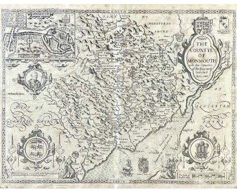
JOHN SPEED. 'Hereford-Shire described'. 'with the true plot of the Citie of Hereford as also the armed of those Nobles that have bene intituled with that Dignity,' hand coloured engraved map, an inset town plan of Hereford, toning, centre fold, English text to verso, framed and glaze, Henry Overton, [circa 1713]. 44cm x 56cm


Lot 306
Two works on the Nile and one other. EUSTACE A. REYNOLDS-BALL. 'The City of the Caliphs: A Popular Study of Cairo and its Environs and the Nile and its Antiquities,' Illustrated souvenir edition, highly decorative original cloth with gold embossing and thread work, staining to bottom of spine panel, textblock loosening from binding, spotting to frontis, plates, Dana Estes & Company, Boston, 1897; ROSITA FORBES. 'From Red Sea to Blue Nile. Abyssinian Adventures,' first edition, slight staining to original cloth, front board loosening, ink inscription to front free endpaper, frontis, plates and map, dedication reads 'To Abyssinia and her Heir-Apparent H. I. H. RAS TAFARI', a tidy copy, Cassell and Company, London, 1925; with an eight edition 'Tropical Africa', by Henry Drummond. (3)

Lot 371
T. GWYN ELGER FRAS 'The Moon: A Full Description and Map of its Principal Features.' First Edition, orig cloth, silver, plates and illustrations, top of spine has chips missing and the backstrip is starting to come loose; previous owner has made notes in pencil and biro on the ffep and on the half-title. George Philip & Son, 1895.

Lot 445b
Ruth MANNING-SANDERS. 'West Buckland Year Book, and Kalendar for 1857,' original embossed cloth with some mold staining, spotting to edge of textblock, ex libris label to pastedown John Davies Enys, plates, W. Tucker, South Molton, 1857; EDMUND BOGG. 'The Old Kingdom of Elmet: York and the Ainsty District,' original cloth, rubbed and bumped, small amount of spotting, illustrated, John Heywood, London, 1902; Rev W. THOMPSON. 'Sedbergh, Garsdale, and Dent,' original cloth, rubbed and bumped, loss to free endpaper and halftitle, some spotting, illustrations, Richard Jackson, Leeds, 1892; HARRY SPEIGHT. 'Nidderdale and the Garden of the Nidd: A Yorkshire Rhineland,' original pictorial cloth, loosening textblock, fold out map frontis, illustrations, Elliot Stock, London, 1894; 'Upper Wharfedale,' original pictorial cloth, loosening textblock, plates, Elliot Stock, London, 1900; THOMAS WILLIAM TEW (ed). 'The Sieges of Pontefract Castle,' stainong to original cloth, loss to titlepage, plates, fold out map frontis, Richard Holmes, Pontefract, 1887; With seven other works of topographical interest. (13)

Lot 500
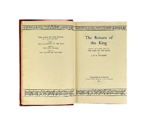
J. R. R. Tolkien first edition. 'The Return of the King,' signature mark '4' to page 49, lacks dj, original red cloth, spine cloth panel split at rear edge, rubbed and bumped, textblock sagging but in vg condition, fold out map to the rear in a fine condition, George Allen & Unwin, London, 1955.

Lot 57
G. B. WORGAN. 'General View of the Agriculture of the County of Cornwall'. Original publishers boards rebacked with modern cloth, ex libris label for 'Trelissick Library', cracked inner joint, fold out map for frontis, contemporary ink signature to titlepage, some margin notes, illustrations complete, a very good example, McMillan, London, 1811.The original spine does appear to be under the new cloth (it is only slightly perceivable), extremities are bumped and turned in. This book is otherwise in a very good condition, with untrimmed fore edge to leaves being slightly toned.


Lot 3182
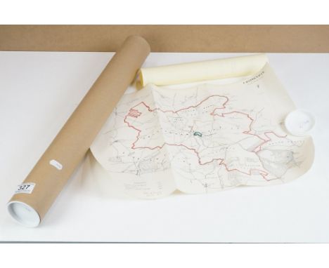
MAPS. A group of seven folding London Transport maps circa 1938-1939, comprising 'Underground Map', 'Underground Railway Map', 'Bus Map Central Area', 'Green Line Coach Map', 'Bus Map Central Area', 'Trolleybus & Tram Map' and 'Bus Map Central Area'.Buyer’s Premium 29.4% (including VAT @ 20%) of the hammer price. Lots purchased online via the-saleroom.com will attract an additional premium of 6% (including VAT @ 20%) of the hammer price.
-
109198 item(s)/page