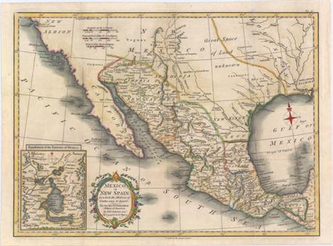

Kitchin, Thomas 1780 Mexico, or New Spain; in Which the Motions of Cortes May Be Traced This is a very attractive map of the American Southwest and Mexico. California is labeled New Albion with no detail outside of a few coastal place names. The region of present-day Arizona and New Mexico is well delineated with numerous Indian villages and the locations of missions. The area from New Mexico to Louisiana is named as ""Great Space of Land Unknown."" The small Texas settlement of Cenis is near the New Kingdm. of Leon. An inset shows Mexico City on the large Lake of Mexico. Finely engraved with a decorative title cartouche and compass rose. This map was originally published in 1777, this being a later edition by T. Cadell. 15.3"" W x 11.2"" H Issued folding, now pressed with light soiling. A binding trim at top right has been replaced with old paper to accommodate framing.
We found 109182 price guide item(s) matching your search
There are 109182 lots that match your search criteria. Subscribe now to get instant access to the full price guide service.
Click here to subscribe- List
- Grid
-
109182 item(s)/page
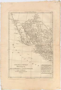
Bonne, Rigobert 1780 L`Ancien et le Nouveau Mexique, avec la Floride et la Basse Louisiane, Partie Occidentale This handsome map covers the region of present day southern California, Arizona, New Mexico, Texas and Mexico. Excellent detail, particularly of the Jesuit missions in Mexico and the Southwest, and of the numerous Indian tribes. The map locates San Diego, Santa Fe, Taos, Acapulco, Cabo St. Lucas and many towns along the Sea of Cortez and Baja Peninsula. Six distance scales at lower right. 9.3"" W x 13.5"" H On watermarked paper with faint offsetting and one small rust spot.

Tanner, Henry Schenck 1834 Mexico & Guatemala This map of the southwest shows Texas as still a part of Mexico but Austins Colony is noted. Sonora extends north into present-day Utah and is wedged between New Mexico and Upper California. The rivers Timpanogos and San Buenaventura run straight through the Great Basin into the Pacific. Insets include the Valley of Mexico and Guatemala. The map presents a great picture of the region prior to Texas declaring its independence. 14.7"" W x 11.7"" H Original color with a few small spots of foxing.

Brue, Adrien Hubert 1840 Carte Generale des Etats-Unis Mexicains de la Republique du Texas et des Etats de l`Amerique Centrale Handsome and uncommon map that details the independent Republic of Texas, the Southwest United States and Mexico. The lower left quadrant is filled with a large inset with Central America shown on the same scale as the main map. The title contains one of the few direct references to the Republic of Texas. Excellent detail throughout. With Brue`s embossed seal and surrounded by a decorative keyboard-style border that indicates longitude from Paris. Fancy title lettering embellished with flourishes. 14.3"" W x 20.3"" H Original outline color with light toning, color offsetting, and a fold separation confined to the left blank margin closed on verso with archival tape. Faint pencil notations in right blank margin.

SDUK Society for the Diffusion of Useful Knowledge, 1849 Central America II. Including Texas, California and the Northern States of Mexico... This excellent map covers the southwestern United States subsequent to Mexico losing the region in the Mexican/American War. Texas is shown at its largest extent with the panhandle extending well north up to Spanish Peaks. All of the Southwest and California are here noted as ""Nueva or Upper California."" Charles Fremonts first expedition up the Oregon Trail and through the Sierra Nevada is traced and there are several notations in the Great Interior Basin of California from that important exploration. Lake Tahoe makes an early appearance as Mountain L. The Great Spanish Track from Pueblo de los Angelos to Santa Fe is also noted. There is great detail throughout including forts, Indian tribes, and numerous interesting notations. This is an updated version of the map first issued in 1842; engraved by J. & C. Walker and published by Charles Knight. 15.8"" W x 12.3"" H There is a hint of toning and one short edge tear just entering the neatline at left that has been closed on verso with archival tape.

Tallis, John 1850 Mexico, California and Texas This is the second, and most desirable, state of this fine steel-engraved map that was issued during a time of great transition in the region. After gold was discovered in California, the plate was re-engraved to include a vignette of gold panning and to locate the gold regions of California which are delineated through hand coloring. Texas is shown with its original state borders that include much of present-day New Mexico and extend into Colorado. Two other vignettes show Mexican peasantry and the ancient Mayan ruins at Uxmal. The very decorative border incorporates native plants of the region. Map drawn and engraved by John Rapkin, vignettes drawn by H. Warren and engraved by J. Rogers. 13"" W x 10"" H Light toning along the centerfold and sheet edges with a few minor spots.

Hondius/Bertius, 1618 Nova Hispania A handsome small map of Mexico and southern Texas, noting numerous rivers and towns, including Mexico City, Guadalajara, and Veracruz (Cruz). The R. de Palmas is approximately where the current border lies between Mexico and Texas, and the R. Escondido is believed to be the Nueces River. Adorned with a decorative cartouche incorporating the distance scale. French text on verso. 5.2"" W x 3.9"" H A fine impression with minor show-through of text on verso and a damp stain in bottom blank margin.

1838 A Map of Mexico and the Republic of Texas This map features a young Republic of Texas and was issued in Niles & Pease`s History of Mexico & Texas. Settlements are confined to the eastern coast and include Houston, San Antonio, Galveston and Nacogdoches to name a few. The states of Mexico are delineated and the map extends to show a portion of Louisiana, Mississippi and Alabama. 16.5"" W x 12.8"" H Issued folding on thin, banknote style paper with moderate offsetting, uneven toning, and remnants of masking tape on verso confined to the blank margins. A 2"" edge tear and two 1"" fold separations have been closed on verso with archival tape, and a chip
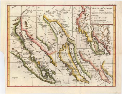
Robert de Vaugondy, Didier 1772 Carte de la Californie Suivant I. la Carte Manuscrite de l`Amerique de Mathieu Neron Pecci... This sheet has five depictions of California that present a fascinating cartographic history of the region. It was one of ten maps compiled by Robert de Vaugondy for Diderot`s important encyclopedia and depicts the mapping of California by five important cartographers. The earliest map reproduces Neron Pecci`s manuscript map of 1604 showing the peninsula with a ragged coastline and place names derived from Cabrillo`s voyage of 1542-3. The second map is a detail from Sanson`s 1656 map showing the island of California with place names from the voyage of Vizcaino. Map three is from Delisle`s map of America of 1700 with the question of California`s insularity left open to interpretation. Next is Fra. Eusebio Kino`s important map of 1705 that finally ended that cartographic myth. It is based on his overland expedition from the mainland to the Sea of Cortez. Finally, map five is a portion of a Spanish map, showing the Jesuit explorations, that first appeared in Miguel Venegas` Noticia de la California in 1757, which is the first published history of California. This is an essential map for any California map collection. 15.3"" W x 11.5"" H Nice impression on a clean sheet with minor printer`s ink residue and a binding trim at lower left.

Bry, Theodore de 1595 Hispaniae Novae Sive Magnae, Recens et Vera Descriptio This is a particularly interesting version of Ortelius` map of Mexico that was the prototype map of the region. It covers the Pacific coast from present-day Acapulco to about Mazatlan and inland to Mexico City, which is situated on a large lake. It is densely engraved with place names and shows the mining districts northwest of Mexico City. The map is elaborately decorated with engravings of Native Americans, bison, canoes, ships and two fabulous cartouches. 17.3"" W x 13"" H A nice example with minor soiling and a few tiny tears in blank margins that have been archivally repaired. Professionally remargined at bottom with old paper and with a minor amount of neatline replaced in facsimile.

Hondius, Jodocus 1619 Hispaniae Novae Nova Descriptio This splendid map illustrates the heart of the Spanish empire in the New World. The map is focused on the western part of Mexico from about Mazatlan to Acapulco (neither of which is named) and inland to include Lake Chapala and Mexico City, which is situated on a large lake. At upper left is a large inland sea filled with islands where the natives supposedly extracted salt. There are numerous notations, taken from Ortelius, that describe the native people including one that refers to cannibalism - Anthropophagi sunt, qui his montibus habitant (They who live in these mountains are cannibal). Diamond-shaped symbols mark the locations of numerous silver and copper mines. The map is fully decorated with three elaborate, strapwork cartouches. A Spanish Galleon and a fanciful sea monster adorn the ocean. Jodocus Hondius prepared this map for inclusion in his editions of the Mercator-Hondius atlas. Latin text on verso. 19"" W x 13.7"" H Old color with light toning, some color offsetting mainly along the centerfold, and an archivally repaired centerfold separation that extends 2"" into the image at bottom.

Coronelli, Vicenzo Maria 1690 Parte della Nuova Spagna, o` del Mexico doue Sono le Provincie di Guadalaira Xalisco Mecoacan e Mexico This scarce and superbly decorative map of western and central Mexico covers from Xiamora to Acapulco and includes Mexico City and Guadalajara along with cities, towns, mines, missions and Indian villages. Notations in the mountains north of Mexico City describe the rich deposits of silver and other annotations describe the manners and customs of the Indians. The active volcano at Popocatepec (Popocatzin) is vividly erupting in the lower right corner. Coronelli, a Franciscan priest, was a highly respected cartographer & globe maker. Largely through his religious connections, Coronelli had access to geographical information from the expeditions exploring the southwestern regions of North America. This map is decorated with an elaborate title cartouche with mythological figures and an equally attractive cartouche for the scale of miles. 23.9"" W x 17.9"" H A fine impression on watermarked paper with attractive color. This is a clean, bright example with a few minor centerfold separations that have been professionally repaired.

Hardy, Lieut. R.W.H Hardy 1829 Travels in the Interior of Mexico, in 1825, 1826, 1827, & 1828 ""This first edition is a vivid and early portrayal of the culture and geography of northwestern Mexico based on the author`s extensive travels in the region. Hardy was in search of pearls in the Gulf of California. The result of his journey is a fascinating book and map on """"the little known regions of Senora and Lower California"""", (Map of Sonora and Gulf of California, 17 x 13""""). This scarce map extends from the Gila River in the north to Mexico City. Most of the eastern portion is blank and shows only western towns, including S. Juan del Rio, Guanaxuato, Guadalaxara, Durango, Chihuahua and much of the Rio Grande River. Curiously, the town """"Arizona"""" is shown south of the Gila River in today`s New Mexico. Scores of villages are named in the northwest. All of Baja is included with only a few towns -- La Paz, Loreto and Mulege. Legend locates Hardy`s route, Ranchos, Gold and Silver Spots, Real di Minas, Mines, Presidio, and Missions. A second map, Plan of the Rio Colorado, by Lieut. R.W.H. Hardy (7.5 x 4.5"""") is the first American exploration and mapping of the Colorado River from its mouth in the Gulf of California to its confluence with the Gila River. A note claims the high water changes by 22 feet. The six called for plates are present and include: The Game of Monte, in the Streets of Mexico; A Pilgrimage Performed in Mexico; A Mexican Cavallero; Morning Salutations in Mexico; Water Carrier in Mexico; and An Evangelista, or Letter-Writer in the Haza Grande of Mexico. Most descriptions list seven plates, but here we count as a map the Colorado River plate. The book is hardbound in green cloth with gilt title on spine. This first edition is complete, 540 pp, two maps and six plates. Published by Henry Colburn and Richard Bentley, London, 1829."" 6"" W x 9"" H The map has light offsetting, a 1"" binding tear, and a small puncture in a blank area of the map near the center. Contents are clean and tight in near fine condition and the spine is lightly sunned. Library stamp on title page and pastedown on inside fr

Montanus/Ogilby, 1671 Nova Hispania Nova Galicia Guatimala This well-engraved map, based on the cartography of Hessel Gerritsz, includes Mexico through Costa Rica with nice detail. It also includes the U.S. Gulf coast, southwest Florida and a bit of Cuba with less detail. The large pictorial cartouche depicts Native Americans loading goods for a European merchant. 14"" W x 11.4"" H A fine impression with wide margins, slightly uneven toning, a small hole near center of map, and an archivally repaired centerfold separation in bottom blank margin.

Visscher, Nicolas 1682 Insulae Americanae in Oceano Septentrionali ac Regiones Adiacentes, a C. de May usque ad Lineam Aequinoctialem This handsome map focuses on the West Indies and covers the region from the Chesapeake through the Gulf of Mexico, with Central America and the northern part of South America. Two lovely cartouches with cherubs and mermaids decorate opposite corners. Eight ships sail the seas and three native canoes are depicted off the coast of North America. A number of interesting cartographic myths appear on the map. These include two large nonexistent lakes in the region of western Georgia and a non-existent mountain range extending from the Piedmonts bearing across the North American continent. In South America, the archetypal cartographic myth, Manoa o` El Dorado (the golden city), is located on the shores of the Lacus Parime vel Roponowini in Guyana. This is the second state with the addition of the privilege in the cartouche. 22.2"" W x 18.2"" H A fine impression in attractive original color with some small stains and a centerfold separations at top and bottom that have been archivally repaired on verso.

Fer, Nicolas de 1705 Le Vieux Mexique ou Nouvelle Espagne avec les Costes de la Floride This attractive small map covers the Gulf of Mexico through Central America and includes parts of Cuba and Jamaica. It extends through Mexico to show the southern tip of Baja California. This is an early map to show the correct location of the Mississippi River delta gleaned from the expeditions of La Salle and Iberville. Two French forts are located: LaSalle`s Fort St. Louis in Texas (Fortbati en 1685) and another near present-day New Orleans. One of the prominent features in northern Mexico is Les Fameuses Mines de Ste. Barbe, the legendary Santa Barbara mines of the Chihuahua-Durango region. The large cartouche features two native figures. Included with the map is a full page of text describing the region. 12.8"" W x 8.8"" H Watermarked paper with light toning and a small worm track in the dedication cartouche that has been closed on verso with old paper resulting in minimal image loss. There are minor damp stains mostly confined to the lower blank margin.

Anville, Jean Baptiste Bourguignon d` 1731 Carte des Isles de l`Amerique et Deplusieurs Pays de Terre Ferme... This detailed map covers the southern U.S., Central America, the West Indies, and northern South America. The map is dense with town names, waterways, and mountains. Florida features prominently here, stretching west just past Mobile Bay to Louisiane and north to Caroline, with its southern portion broken into an archipelago. A decorative title cartouche appears in the top right corner. Engraved by Delahaye. 17.3"" W x 12"" H Issued folding on watermarked paper with a binding tear at right that just enters the neatline that has been closed on verso with archival tape, a line of minor toning down the map`s center, and faint offsetting.

Homann Heirs, 1740 Mappa Geographica, Complectens I. Indiae Occidentalis Partem Mediam Circum Isthmum Panamensem II. Ipsumq. Isthmum. III. Ichnographiam Praecipuorum Locorum & Portuum ad has Terras Pertinentium... This informative and very graphic folio sheet has a large map of the region, titled ""Carte des Isles de l`Amerique et Deplusieurs Pays de Terre Ferme,"" attributed to D`Anville (1731). It covers the Gulf of Mexico, Central America and all of the Caribbean islands. It is nicely detailed with a key to show European possessions and a beautifully engraved title cartouche. Above the main map is the large, decorative title cartouche, flanked by insets of the isthmus of Panama and a plan of St. Augustine in Florida. Below the map is a large view of Mexico City, flanked by plans of Vera Cruz and San Domingo. A very handsome sheet, absolutely filled with information on the West Indies. 19.1"" W x 22.6"" H Original color on a sturdy, watermarked sheet with light toning confined to blank margins.

Bowen, Emanuel 1747 An Accurate Map of the West Indies. Drawn from the Best Authorities, Assisted by the Most Approved Modern Maps and Charts, and Regulated by Astronomical Observations This handsome map covers the southeastern United States, eastern Mexico, Central America, the West Indies, and the northern part of South America. It is derived from Popple`s important map of the region. The British colonies in North America are confined east of the Appalachians with France in control of Louisiana. Many early forts and Indian tribal territories are located. There are several interesting notations concerning the history of the region, such as a notation concerning the southern boundary of the Province of Carolina, ""so that Fort St. Augustin as well as Georgia falls within these limits."" Trade winds and sea routes are marked throughout, including the course of the Spanish gold fleet from Old Spain and the return trip from Cartagena and Vera Cruz. The title cartouche is adorned with Native Americans and an incongruous lion (likely representing the British colonies). This is the second state. 16.5"" W x 13.6"" H Issued folding, now pressed flat, with minor soiling and light offsetting concentrated along the centerfold, as well as centerfold separations at top and bottom that have been closed on verso with archival materials.

Sayer & Bennett, 1779 A New General Chart of the West Indies from the Latest Marine Journals and Surveys, Regulated and Ascertained by Astronomical Observations A spectacular, large-scale chart of the Gulf of Mexico, Florida and the Caribbean printed on two separate sheets and joined. The map is extremely detailed, and filled with information on coastal features, soundings, shoals and hazards. It extends to Central America and the northern tip of South America. The colonial possessions are denoted in color: pink for the British, yellow for the Spanish, and green for the French. The title is surrounded with a well-engraved cartouche comprised of items relating to the trade in the region. An uncommon map. 40.2"" W x 27.3"" H Issued folding on watermarked paper with original color, archival repairs to a few short fold separations, and very light toning along one fold. There are a few light spots of foxing and minor soiling. Please note that the bluish shadows running vertica

Bonne, Rigobert 1780 L`Ancien et le Nouveau Mexique, avec la Floride et la Basse Louisiane, Partie Orientale This nice map covers the Gulf of Mexico and Central America through Panama and includes most of Cuba and the Bahamas. It provides a good amount of detail along the gulf coast, including the Mississippi to above its conjunction with the Ohio. 9.3"" W x 13.7"" H Watermarked paper with a few minor spots in the image, else very good.

Robert de Vaugondy/Delamarche, 1785 Nouvelle Espagne, Nouvelle Mexique, Isles Antilles This attractive, small map was reissued by Delamarche, who was the successor to the Robert de Vaugondy family of mapmakers. It details the southern portion of North America, Central America, the West Indies and the northern tip of South America. The Azores are represented in an inset at the top right, and below the scales of miles is an additional title: ""les Audiences de Guadalahara, de Mexico, et de Guatimala, forment Le Mexique ou Nouvelle Espagne."" Engraved by E. Dussy. 12"" W x 9.5"" H Watermarked paper with some extraneous creases in left blank margin.

Lapie/Tardieu, 1806 A Map of the West-Indies and of the Mexican-Gulph / Carte des Indes Occidentales et du Golfe du Mexique This extremely rare large-scale map of the Gulf of Mexico shows the European possessions through a color-coded key adjacent to the title cartouche. The regions and islands controlled by the French, Spanish, British, Danish, Dutch, and Swedish are shown, along with the area belonging to the United States. This map was published shortly after the Louisiana Purchase in 1803, and shows the United States in control of Louisiana. Florida is divided into East and West, and extends to the Mississippi River. There is great topographical detail throughout, and rivers and place names fill the map. Engraved by Tardieu and separately issued in Paris by Tardieu and Dezauche. 29.1"" W x 19"" H Printed on heavy, bluish, watermarked paper with very minor offsetting.

Mitchell, Samuel Augustus 1860 Map of Mexico, Central America, and the West Indies This double-page map of Mexico and the West Indies extends to include the southern states, all of the Caribbean and Bahama Islands, and a portion of northeastern South America. There is excellent detail throughout Mexico and Central America. The Baja Peninsula is here called Lower California. Four insets show Cuba, Jamaica, Bermuda Islands and a map of the Panama Railroad. 21"" W x 13.1"" H A clean and bright example with two short edge tears that have been closed on verso with archival tape - one is confined to the top blank margin and the other just enters the map border at left.

Duval, Pierre 1682 Isles Antilles This miniature map of the Caribbean includes southern Florida and the Bahamas, and depicts major towns and key topographical features. Pierre Duval was Nicolas Sanson`s nephew and pupil. He published a wide range of atlases and individual maps including a fine miniature world geography with many of the maps based on Sanson. 5"" W x 4"" H Watermarked paper with wide, original margins and one tiny rust spot in title cartouche.

Sanson, Nicolas 1683 Les Isles Antilles, &c entre Lesquelles sont les Lucayes, et les Caribes Attractive map covering the southern tip of Florida and all of the Caribbean islands. There is good detail, especially on Cuba and Hispaniola, which display numerous place names and mountains in profile. Engraved by Antoine d`Winter. 12.2"" W x 8.2"" H Light toning, minor soiling, and one small hole in border at top left. There are a few tiny tears and chips in blank margins, and the left margin has been extended with old paper.

Fer, Nicolas de 1702 Les Isles de l`Amerique Connues sous le Nom d`Antilles, ou Sont les Isles de Cuba, St. Domingue et Jamaique les Lucayes, les Caribes, et celles du Vent There are a number of interesting historical and geographical notes on this map of the Caribbean. The map extends north to the Bahamas and the tip of southern Florida and encompasses the eastern shore of the Yucatan, parts of Central America, Panama and the northwest coast of South America. Between Florida and Cuba and the Bahamas, a reference to the Gulf Stream notes that is always flows north. Engraved by Herman van Loon with a handsome title cartouche and a small central compass rose. 13.2"" W x 8.8"" H Watermarked paper with some light damp staining confined to the lower blank margin.

Jefferys, Thomas 1760 The West Indies Exhibiting the English, French, Spanish, Dutch & Danish Settlements This is an uncommon map of the Caribbean showing the colonial holdings of Britain, France, Spain, the Netherlands and Denmark during the Seven Years` War. Southern Florida is shown with large, interconnected waterways effectively turning the region into an archipelago. The boundary between Florida and Georgia is labeled Limits Stipulated in 1738. There is good detail of the rivers, mountains, and coastal place names throughout. This map was published in The Natural and Civil History of the French Dominions in North and South America, Jefferys` monumental geographical and historical work describing Canada, Louisiana and the French possessions in the West Indies. This map is rarely offered on the market. 17.7"" W x 18.4"" H A nice impression, issued folding, now pressed with light offsetting and a few fold separations that have been professionally repaired. There is a binding tear at right that enters 1.5"" into image that has also been professionally repaired.


Bonne, Rigobert 1785 L`Isle de Cuba Attractive copperplate engraving of Cuba and the Bahamas. It is geographically accurate with some overall scale distortion, most notably in present-day Bay de Buena Vista, Golfo de Batabano, and Golfo de Guacanayabo. In the lower part of the map are the Cayman Islands and in the north are part of the Florida Keys to include the Tortugas. Interior and coastal information includes shoals, towns, missions, hospitals and plantations. The southern coast is a fragmented collection of islands and shoals. 12.6"" W x 8.5"" H Watermarked paper with light offsetting and soiling.
![Le Rouge, George Louis 1746 La Jamaique aux Anglois dans le Golfe du Mexique [on sheet with] La Bermude aux Anglois These tw](http://lot-images.atgmedia.com/SR/36385/2901770/377-201425154444_468x382.jpg)
Le Rouge, George Louis 1746 La Jamaique aux Anglois dans le Golfe du Mexique [on sheet with] La Bermude aux Anglois These two maps on one sheet show the British Possessions in the Caribbean and the Atlantic Ocean, Jamaica above Bermuda. Jamaica is engraved to show the plantations, denoting those growing sugar, cotton, cacao, and indigo. The map of Bermuda includes an interesting cartographic error which resulted from copying John Speed`s map of 1627. In that map, Bermuda was superimposed over a map of the coastline of New England and Virginia to show the relative position of Bermuda in addition to the main map of the island. Le Rouge dropped the coastlines of North America, but left the small depiction of Bermuda, which appears on this map as a small offshore island named Bermudos. 10.7"" W x 8"" H On watermarked paper with two pairs of minute symmetrical wormholes on either side of the centerfold.

Hondius/Bertius, 1618 Hispaniola A beautiful miniature map of the island also showing the eastern tip of Cuba. The ribbon style title cartouche incorporates the distance scale and the map is ornamented with a sea battle and two sea monsters. French text on verso. 5.3"" W x 3.8"" H A fine impression with minor show-through of text on verso and a damp stain in bottom blank margin.

Delisle/Covens & Mortier, 1730 Carte de l`Isle de Saint Domingue Dressee en 1722 pour l`Usage du Roy sur les Memoires de Mr. Frezier This is an important map of Hispaniola and the Turks & Caicos Islands. When initially published in 1722 by Delisle it was one of the first to depict the island`s true contours following Frezier`s important map of the island. The chart provides excellent detail of the three districts showing mountains, roads, towns, ports, plantations, sugar works and navigational hazards. Decorated with a large title cartouche and compass rose. Latin title above, ""Insulae S. Dominicae Tabula Accuratissima."" 24.1"" W x 18.6"" H Original color with a hint of toning along sheet edges.

Carey & Lea, 1822 Geographical, Statistical, and Historical Map of Porto Rico and the Virgin Islands The map is on a full folio sheet (20.8 x 16.5"") with English text giving a brief description of the islands, chief towns, population, government and history. Shows good detail along the coastline with little inland information. Colored to show the possessions of the English, Dutch and Spanish. Engraved by Kneass. 17.2"" W x 10.3"" H A strong impression on a sheet with a six-pointed star watermark. There is faint offsetting and toning along the centerfold.
![Le Rouge, George Louis 1748 Isle St. Christophle une des Antilles aux Anglois [on sheet with] La Barbade une des Antilles au](http://lot-images.atgmedia.com/SR/36385/2901770/383-201425154455_468x382.jpg)
Le Rouge, George Louis 1748 Isle St. Christophle une des Antilles aux Anglois [on sheet with] La Barbade une des Antilles aux Anglois Divisee par Paroisses Small map of the islands of St. Kitts and Barbados on one sheet, with parish divisions shown on Barbados and rocks noted around the islands by a small `x`. The cities, churches, and other sites of interest are located by means of a key at the lower left. 8.1"" W x 10.9"" H On watermarked paper with one small rust spot and faint soiling confined to the blank margins.

Bellin, Jacques Nicolas 1757 Carte de de l`Isle St. Christophe pour Servir a l`Histoire Genle. des Voyages This lovely map of St. Kitts is fully engraved with mountains, rivers, lakes, and towns. The island has twelve quarters and parishes, which are sometimes indicated by hand coloring, but not on this example. In the center of the island a note on the mountain Mont Misery locates Mines de Souffre. Grande Saline, Ville de la Basse Terre, forts, churches, and more are identified. Decorated with baroque-style title and scale of miles cartouches and a fleur-de-lys. 12.2"" W x 7.8"" H There is minor foxing and toning confined to the blank margins.

Bew, John 1782 An Accurate Map of the Island of St. Christophers, from an Actual Survey Shewing the Parishes, Churches, and Rivers... Handsome map of this Leeward island with detail of cities, towns, forts, plantations, and parishes. The surroundings waters are filled with depth soundings, shoals, and rocks. Engraved by John Lodge. 14.5"" W x 10.9"" H Issued folding, now pressed on watermarked paper with minor soiling and offsetting and a narrow left margin.

Bew, John 1782 A New and Exact Map of the Island of Antigua in America, According to an Actual and Accurate Survey, with the Different Parishes, the Churches, Divisions, Boundaries; and a Plan of English Harbour This attractive small map of Antigua was reduced from Robert Baker`s large survey of the island. The divisions and parishes are noted and there is a considerable amount of interior detail provided including the locations of churches. The coastal soundings and hazards are meticulously identified, with excellent notes of submerged rocks and other hidden dangers. A plan of English Harbour is included in an inset map. 14.5"" W x 11"" H Issued folding, now pressed, on watermarked paper with a hint of offsetting and light tissue reinforcing the folds on verso.

Hondius/Bertius, 1618 America Meridionalis This handsome miniature map of South America still depicts numerous geographical myths. A massive Terra Australis is separated from the continent by the Strait of Magellan, with no mention of Tierra del Fuego. Within the continent, two mythical lakes appear: Eupana Lacus, which connects the Amazon River to the Parana River; and Parime Lacus (here not named), with the fabled golden city of Manoa on its northern shore. Handsomely embellished with two sailing ships, a sea monster, and a strapwork title cartouche. The majority of the maps for Bertius` geographical treatise were engraved by Jodocus Hondius Jr. after Mercator, although there is no attribution on this map. French text on verso. 5.2"" W x 3.8"" H A fine impression on watermarked paper with two small stains in blank margins, not affecting map.

Herrera y Tordesillas, Antonio de 1622 Descripcion de las Yndias de Mediodia Antonio de Herrera Y Tordesillas was the official historian of Spain and the Indies. He compiled a history of the Spanish conquests and early explorations in the Americas, which included this simply engraved map of the continent. This rare map is largely derived from the manuscript charts of Juan Lopez de Velasco. The continent is dominated by the huge R. de los Amazona and R. de la Plato and the western mountain range. The Papal Line of Demarcation (Meridiano de la de Marcacion), which divided the non-Christian world between Spain and Portugal, divides the continent between Portugals tiny Brazil with the rest (Peru) belonging to Spain. 11.5"" W x 8.6"" H Watermarked paper with wide, original margins, light toning, and a few small spots of foxing.
![Fer, Nicolas de 1705 [Lot of 2] La Terre Ferme et le Perou avec le Pays des Amazones et le Bresil dans l`Amerique Meridional](http://lot-images.atgmedia.com/SR/36385/2901770/394-201425154514_468x382.jpg)
Fer, Nicolas de 1705 [Lot of 2] La Terre Ferme et le Perou avec le Pays des Amazones et le Bresil dans l`Amerique Meridionale [and] Le Chili et les Provinces qui Composent Celle de Rio de la Plata avec les Terres Magellanique ""This pair of maps combine to create a map of the continent, although each map stands on its own with full borders and a drape-style cartouche. Both maps were finely engraved by Charles Inselin. Size varies slightly. The northern map gives great detail of the Amazon River and its tributaries. Possible connections between the Paraguay River and the Amazon or Sao Francisco Rivers are depicted. Numerous towns are identified, primarily along the coasts, with several notations throughout the map. On the southern map, detail is again mostly confined along the coastlines, but there are some inland features including rivers, lakes, marshes and the locations of missions. The Andes are noted as a vast volcanic cordillera. A table of longitudes and latitudes of key cities and the publisher`s imprint are presented on a large chest, which is also supporting a globe, compass and armillary sphere."" 13.5"" W x 9.1"" H Nice impressions on watermarked paper with one small, professionally repaired hole in the Atlantic Ocean on the southern map and light printer`s ink residue.

Albrizzi, Girolamo 1740 Carta Geografica della America Meridionale Beautifully engraved, Italian edition of Delisle`s map of South America, extending from Nicaragua to Tierra del Fuego. Place names in South America are focused primarily along the coasts and along the Amazon and Parana Rivers. Two mythical lakes still appear: Lago Cassipa Dorada (a smaller version of the more-commonly known Lac de Parime) with the fabled city of Manoa to the southeast, and Lago des Xarayes in the center of the continent. Central Brazil is left blank except for a note explaining that the Brazilians claim that the S. Francesco and Real Rivers run for a long time together and connect with the Rio della Plata (Parana River). The south Pacific is also depicted with the routes of various explorers shown, including Magellan, le Maire, Olivier van Noort, and Mendana, with a portion of the Salomon Islands depicted. The large pictorial title cartouche features a mounted female surveying galleons in the distance and a hunter attempting to spear an alligator. 16.9"" W x 13"" H A nice impression on watermarked paper with attractive color and two minute worm holes only visible when held to light. There are minor creases adjacent to centerfold at top of map and in top blank margin.

Homann Heirs, 1740 Tabula Americae Specialis Geographica Regni Peru, Brasiliae, Terrae Firmae, & Reg: Amazonum... This large map covers the northern half of South America centered on the Valley of the Amazon. It delineates the river and its tributaries in particularly fine detail and is filled with annotations and place names. The title is enclosed in a very large allegorical cartouche with soldiers, a personified sun burst, and a pot of coins. 22.2"" W x 18.9"" H Watermarked paper with minor printer`s ink residue and a few soft creases.

Hondius, Henricus 1636 Venezuela, cum Parte Australi Novae Andalusiae Beautifully engraved map based on the cartography of Hessel Gerritsz covering the northern coast of South America, Venezuela, east to the mouth of the Orinoco, and including the offshore islands from Aruba through Dominica and Tobago. The fine engraving illustrates the mountains, forests, rivers and indigenous animals but shows place names primarily along the coastlines owing to the relatively few explorations made into the interior. The map is richly embellished with title and distance scale cartouches, compass roses and a galleon. Engraved by Evert Symonsz Hamersveldt and S. Rogeri. German text on verso. 19.2"" W x 14.9"" H Nice impression and color with wide original margins, minor printer`s ink residue in the image, and just a few small areas of paper weakness at far left and right.

Blaeu, Willem 1642 Guiana sive Amazonum Regio ""Blaeu`s beautiful map of Guiana covers the coastline from the Isla Margarita in the northwest to the coast of northern Brazil near Sao Luis east of the Amazon delta. At center lies a large inland sea, Parime Lacus; on its northwestern shore is the fabled city Manoa del Dorado, or the golden city of the Incas. The search for this city led many explorers, including Sir Walter Raleigh, on wild adventures through the jungles. The map is beautifully decorated with three cartouches, ships engaged in a sea battle, a sea monster, and a fine compass rose. Dutch text on verso, published between 1642-64. This is a fascinating and rare example, in which the publisher accidentally printed Blaeu`s map of Guinea on the sheet. After realizing the mistake, he printed the correct map of Guiana on a separate sheet, and then carefully pasted it over the map of Guinea. When holding this map up to the light, the underlying map can clearly be seen hiding behind the pastedown. This unique piece gives insight into the complexity of the printing process and the high cost of reprinting sheets. One can image that perhaps the copper plates were organized alphabetically by title!"" 19.4"" W x 14.7"" H A nice impression and original color on a sound sheet with wide margins. There is minor show-through of the Guinea map. The bottom corner of the pastedown, extending just a bit into the map border, was torn off and reattached, most likely during

1763 Carte de la Guyane Francoise ou France Equinoxiale Grand, Beau et Tres Fertile Pays de l`Amerique Meridionale, Situee, Entre la Riviere de Marauny, et le Cap Nord... This scarce and handsome map depicts the coastline between the Maroni River along the western border of French Guiana to the Araguari River, just north of the Amazon River. There is good detail of the rivers, mountains, and settlements in the region. There are several notations regarding the quality of the land and the location of Native Indians, including one that explains that ""this land is very good and is inhabited by the Maures, with whom we are at war."" At right are large insets of St. Lucia, incorrectly oriented with the northern end of the island pointing west, and a bird`s-eye plan of the city of Cayenne with numerous locations identified by a lettered key. An extensive description of the region accompanies the map. Below the main title is the imprint of Mr. Beteow, who is not listed in Tooley`s Dictionary of Mapmakers. 18.1"" W x 14.6"" H Watermarked paper with light toning along centerfold, minor soiling, and a few minute worm holes only visible when held to light.

Hondius/Jansson, 1652 Accuratissima Brasiliae Tabula Magnificent depiction of Brazil with north oriented to the right by a handsome compass rose. The map is inset with two regions of Dutch interest in the area; Baja de Todos los Sanctos and Pernambuco. The interior is bereft of geographical information except for largely imaginary rivers and forests. Instead the region is filled with dramatic scenes of the indigenous people, including warfare and cannibalism, and some curious wildlife. The hereditary captaincies established by the Portuguese are noted along the coastline. The decorative title cartouche is flanked by a native family and the seas are adorned with sailing ships, a sea monster and a compass rose. French text on verso, published between 1652-58. 19.3"" W x 14.9"" H Attractive old color with light toning, minor printer`s ink residue, a few spots of foxing, and several professionally repaired centerfold separations.

Duval, Pierre 1682 La Plata This miniature map of Paraguai (Uruguay) is centered on the Rio de la Plata and depicts major towns and key topographical features. Pierre Duval was Nicolas Sanson`s nephew and pupil. He published a wide range of atlases and individual maps including a fine miniature world geography with many of the maps based on Sanson. 4.8"" W x 3.9"" H A fine impression with attractive color on watermarked paper and light toning along the centerfold.

Bellin, Jacques Nicolas 1771 Carte du Paraguay et des Pays Voisins pour Servir a l`Histoire des Etablissemens Europeens Detailed chart covering the region of northern Argentina with Paraguay, Uruguay, southern Brazil and part of Bolivia and Chile. The mythical Lac des Xareyes is shown as the source of the La Plata River at the top of the map, and Buenos Aires is shown at the bottom. Engraved by A. v. Krevelt. 12.2"" W x 8.2"" H Fine impression with original color and light toning along sheet edges.

Bertius/Claesz, 1606 Peru An interesting miniature map of Peru oriented with north at right, and extending into Ecuador, Bolivia and Chile. Major cities and villages are noted, including Quito, Lima, Cusco and La Paz. A simple strapwork cartouche and moire-patterned sea adorn the map. Latin text on verso. This map was originally published in Cornelis Claesz` Map-Treasury, with maps engraved by Jodocus Hondius and Pieter van den Keere. 4.9"" W x 3.5"" H There is some printer`s ink residue at bottom of map and two small worm holes in right blank margin, not affecting image.

Hondius/Blaeu, 1635 Peru Beautifully engraved map based on the cartography of Hessel Gerritsz. The map covers the Pacific coast of South America from Ecuador as far south as the Atacama Desert in the northern reaches of Chile. It includes the Potosi silver mines, Titicaca, Cusco, Quito and numerous other towns and villages. The dramatic strapwork cartouche incorporates both the title and the distance scales. A large compass rose orients the map with north to the left. It is further decorated with four Spanish galleons and three sea monsters. This is one of the plates that Blaeu acquired from the widow of Jodocus Hondius in 1629. French text on verso. 19.4"" W x 14.9"" H Nice impression and color on watermarked paper with a faint extraneous crease adjacent to the centerfold and two small worm tracks near center of map that have been professionally repaired.
![1645-84 [Lot of 2] Callao [and] Vertoning van `t Callao de Lima ""In 1614 the Dutch West India Company dispatched](http://lot-images.atgmedia.com/SR/36385/2901770/415-201425154554_468x382.jpg)
1645-84 [Lot of 2] Callao [and] Vertoning van `t Callao de Lima ""In 1614 the Dutch West India Company dispatched a fleet of ships under the command of Joris van Spilbergen to promote Dutch trade in South America and the East Indies. Over the next decade, numerous battles ensued between the Dutch and the Spanish, who maintained control over the important port city of Callao. These engravings depicts two of those battles. A. Callao, by Alain Manesson Mallet, from Beschreibung des Ganzen Welt-Kreisses , circa 1684 (4.1 x 5.5""""). This engraving depicts a fleet of galleons in the harbor engaged in battle with an army of infantry on land. The city of Callao is depicted in the background. Condition: Watermarked paper with light soiling. B. Vertoning van `t Callao de Lima, by Jacques l`Hermite, from Iovrnael van de Nassausche Vloot, circa 1645 (8.0 x 6.1""""). On May 12, 1624 Dutch Admiral Jacques L`Hermite attacked Callao and succeeded in burning 30 Spanish ships. This engraving was published in L`Hermite`s account of his voyage around the world from 1623-26. This bird`s-eye view shows the port of Callao with Spanish and Dutch ships in the bay, engaged in battle. Each of the Dutch ships are labeled on the map, including the Hollandia, the Delft, the Amsterdam, and the Eendracht. A compass rose orients north to the bottom left. Condition: There is one small hole in an unengraved area of the image. There is some paper weakness in top blank margin, with one small tear that has been archivally repaired."" "" W x "" H See description above.
![1713-70 [Lot of 2] Plan of the City of Lima Capital of Peru [and] Plan de la Ville du Callao Scituee ala Cote du Perou par 1](http://lot-images.atgmedia.com/SR/36385/2901770/417-201425154557_468x382.jpg)
1713-70 [Lot of 2] Plan of the City of Lima Capital of Peru [and] Plan de la Ville du Callao Scituee ala Cote du Perou par 12 7 de Latitude Australe ""A. Plan of the City of Lima Capital of Peru, by Thomas Jefferys, circa 1770 (6.7 x 5.6""""). A lovely bird`s-eye plan of the city of Lima with a numbered key at left identifying numerous locations on the map including churches, hospitals, monasteries, palaces, the university, a copper mill, and the cathedral. Condition: Issued folding, with a hint of offsetting from an opposing text page. B. Plan de la Ville du Callao Scituee ala Cote du Perou par 12 7 de Latitude Australe, by Frezier, dated 1713 (11.4 x 6.9""""). This bird`s-eye plan of Callao includes a lettered key identifying various churches and a numbered key naming the bastions fortifying the city. Below the plan is a land approach view of the port city. The cartouche is surrounded by flags, cannons, shields, and other weaponry. A compass rose orients north to the bottom left. Condition: Watermarked paper with attractive color."" "" W x "" H See description above.
![1806-41 [Lot of 3] Viceroyalty of Peru [and] Charte der Provinz oder Audiencia von Lima oder des Alten Konigreichs Peru [and](http://lot-images.atgmedia.com/SR/36385/2901770/418-201425154559_468x382.jpg)
1806-41 [Lot of 3] Viceroyalty of Peru [and] Charte der Provinz oder Audiencia von Lima oder des Alten Konigreichs Peru [and] Perou et Bolivie ""This lot of 3 maps illustrates the fascinating political changes that took place in Peru during the first half of the 19th century. A. Viceroyalty of Peru, by Cadell & Davies, dated 1806, hand color (8.1 x 9.9""""). This topographical map depicts Peru extending from Tumbes in the north to past Iquique in the south, well into present-day Chile. Lake Titicaca falls entirely outside of Peru, in the Viceroyalty of La Plata; however the eastern border of Peru encompasses portions of Brazil and Bolivia. Mountains are shown by hachures and rivers are well delineated. Engraved by Lowry. Condition: Watermarked paper with light soiling and one tiny hole in image. B. Charte der Provinz oder Audiencia von Lima oder des Alten Konigreichs Peru, by Weimar Geographisches Institut, dated 1820, hand color (11.5 x 16.3""""). This map was published just 4 years before Peru gained its independence from Spain, and again shows Peru extending from Tumbes in the north to past Iquique in the south, however the Viceroyalty only encompasses a narrow strip along the coast. The majority of the region surrounding the Maranon River is labeled Land der Missionen oder der Amazonen. The map is filled with information on the river systems, mountains, towns, and political boundaries. Condition: Original color on watermarked paper. Issued folding with light offsetting and a few small spots. There is a binding trim at bottom left, but still ample room for framing. C. Perou et Bolivie, by Frederic Lacroix, from L`Univers Pittoresque Histoire et Description de tous les Peuples, de Leurs Religions, Moeurs Coutumes, etc., dated 1841, black & white (9.0 x 6.9""""). Peru, now an independent country, still extends south into present day Chile, and now also encompasses a portion of Lake Titicaca. However Bolivia extends west almost to Cusco. The northeastern portion of Peru is labeled Pays Inconnus (land unknown). There is good detail of the rivers and mountains, with a few place names primarily near the coast. Engraved by Jenotte. Condition: Issued folding with a few tiny spots."" "" W x "" H See descriptions above.

Fullarton, Archibald & Co. 1860 West Coast of South America Including Chili & Part of Bolivia & Peru This sheet contains four maps encompassing the western coast of South America from southern Peru to Taitao Peninsula in Chile. The top map includes charts of the principal mountains and passes in the region with their heights. The maps are surrounded with vignettes of regional figures and animals, as well as a view of Valparaiso. Drawn and engraved by J. Dunlop. 12.5"" W x 18.7"" H Attractive color on a clean sheet with a narrow right margin, as issued.

Chatelain, Henry Abraham 1719 Carte du Paraguai, du Chili, du Detroit de Magellan &c. Dressee sur les Memoires les Plus Nouveaux & les Observations les Plus Exactes Large, finely engraved map of the southern part of South America with great topographical detail and notations throughout. The tracks of several explorations are noted in both oceans and Amerigo Vespucci`s ship is shown sailing in the Atlantic. A depiction of a water fowl is also shown in the Atlantic, with a note that there are a lot of animals in the arctic waters that are ""half bird and half fish."" 20.3"" W x 15.9"" H A nice impression on watermarked paper with light, scattered stains, and archivally repaired centerfold separations at top and bottom. There are a few small holes at bottom of image near centerfold that have also been archivally repaired.

Homann Heirs, 1733 Typus Geographicus Chili Paraguay Freti Magellanici &c. Handsome, detailed map covering the southern part of the continent based on the cartography of Delisle and the information gleaned from the voyages of Brouwer, Narbouroug and Beauchesne. Filled with information of settlements, missions, forests, rivers, volcanoes and mountains. In the lower right corner is an inset plan of the city of Santiago and in the lower left corner is a decorative title cartouche incorporating an erupting volcano. 22.4"" W x 19"" H Watermarked paper with minor toning and a few soft creases.

Hondius/Bertius, 1618 Magellanici Freti Delineatio Miniature map of the strategic Strait of Magellan. Tierra del Fuego is still shown as a large landmass with the strapwork title and scale cartouches conveniently obscuring its extents. The tiny map is beautifully engraved with a stippled sea, elaborate compass rose and penguins decorating the scale cartouche. French text on verso. 5.4"" W x 3.8"" H A nice impression with minor show-through of text on verso.

Fer, Nicolas de 1700 Le Detroit de Magellan... This attractive map provides excellent detail of the coastlines, soundings, anchorages and navigational hazards of the Strait of Magellan. The title is enclosed in a large drape style cartouche. Finely engraved by Charles Inselin. 13.4"" W x 8.9"" H A nice impression with a few small spots and a hint of offsetting.

Thornton, Samuel 1706 A New Mapp of Magellan Straights Discovered by Cap. John Narbrough (Comander Then of His Majesties Ship the Sweepstakes) as He Sayled Through the Sade Straights ""In 1670, John Narborough was the first Englishman to sail through the Strait of Magellan in both directions; thus demonstrating the falsity of the accepted wisdom that the wind and currents would prevent any eastward passage of the strait. He had been commissioned by James, Duke of York (later James II), to sail to South America to investigate potential trade possibilities. Narborough`s expedition proved that a profitable trade with South America was possible, and this set the course of Britain`s foreign policy for the next half century. Narborough published his journal of the voyage in An Account of Several Late Voyages in 1694. His description of the Strait of Magellan provided the basis for British charts of the strait until the time of Captain Cook. This map is closely based on the map from Narborough`s book, and provides a detailed view of the tortuous course of the strait with soundings and safe anchorages carefully noted. There are several notations along the coasts describing the countryside. A large inset map shows Patagonia and Tierra del Fuego. This re-issue was first published by John Thornton with the addition of numerous embellishments, including the English royal coat of arms of Charles II, a European soldier, Native Americans, ships, animals such as a rhea and guanaco, and a native American dwelling. Samuel Thornton, John Thornton`s brother, took over John`s business in 1706, and then re-published the map with his own imprint, as seen here. Both the original Narborough map and the Thornton re-issues are extremely scarce. We have only found one record of either states of the Thornton map being on the market in the past 25 years."" 20.8"" W x 16.6"" H Wide, original margins with a hint of toning along centerfold. A very nice, clean example.
-
109182 item(s)/page