We found 109182 price guide item(s) matching your search

Refine your search

Year

Filter by Price Range
  • List
  • Grid
  • 109182 item(s)
    /page

Lot 1023

John Blair (d. 1782), engraved map - ‘A Map of the East Indies from the latest Authorities and Observations’, 1754, 43cm x 55cm

Lot 1061

John Senex (d.1740), hand-coloured map - ‘A New Map of India and China’, 1721, 50cm x 59cm.Condition report: some losses and numerous tape repairs to edges, image is mostly ok

Lot 1065

Jan Jansson (1596-1664), hand-coloured map - ‘Insulae Javae....’ 1657-1658, Latin text verso, 41cm x 53cm.Condition report: Repair to tear at foot of spine, slightly into image, otherwise ok

Lot 1044

Frederick de Wit (1610-1698), hand-coloured map - ‘Tabula Indiae Orientalis’, dated 1662, 47cm x 56cmCondition report: Some losses to margins, browning to paper and general time-staining, a few tears from lower edge

Lot 989

Edward Wells (1667-1727), hand-coloured map - ‘A New Map of the East Indies’, 1700, 36cm x 50cmCondition report: significant staining to spine, repair to spins, deterioration to periphery, patch to lower right corner

Lot 1080

Pierre van der Aa (1659-1733), engraved map - ‘Les Indes Orientales’, 29cm x 34cm, 1714, together with another ‘Les Isles de Banda’. (2)Condition report: Both with toile staining and creases but generally ok

Lot 1047

Antonio Zatta (fl. 1757-1797), hand-coloured map - ‘Isole Filippine’ published Venice 1784, 33cm x 42cmCondition report: Generally good

Lot 996

Johannes Van Keulen (1654-1715), hand-coloured map - ‘Pas Kaart van de Vaar weg van Straat Blanca af totaan palo Temaon inhoutende de Straaten Drioens, Sabon, Brouwer en Sincapoera’, 1753, 57cm x 47cmCondition report: old yellowed tape repairs, small holes incl.uding in the area of the title cartouche, creases and general strains / marks particularly to margins

Lot 972

Group of 19th century maps of Far East - including five by Archibald Fullarton & Co., large hand-coloured map of Asia, by William Faden, small map by Findlay and two charts by Depot de Cartes et Plans de la Marine, Paris (9).

Lot 1011

Herman Moll (d. 1732), large hand-coloured map,‘A map of East Indies.... to Ye Directors of Ye Hon.ble United East-India Company’, 1717, 62cm x 101cm.Condition report: Some tape to edges and creases arresting tears, creasing and minor stains, generally good

Lot 975

Henricus Hondius (1597-1651), hand-coloured map - ‘India Orientalis ..Insulae Adiacentes’, 1638, French text verso, 39cm x 49cm.Condition report: Patch repair to base of spine, general staining

Lot 1001

Guillaume de L’Isle (1675-1726), hand-coloured map - ‘Carte des indes et de la Chine’, ‘Chez Jean Covens et Corneille Mortier’, 1700, 62cm x 63cm.Condition report: Very small hole at centre fold basically good condition

Lot 973

Capt, George Hayter (18th century), hand-coloured map - ‘A General Chart of the China Sea’, dated 1778, 84cm x 62cm.Condition report: Good condition

Lot 995

John Speed (1552-1629), hand-coloured map - ‘A new map of East India’, 1676, English text verso, 39cm x 49cm.Condition report: Tape repairs to spine and top edge, some staining but generally ok

Lot 1009

Alessandro Malaspina (18th/19th Century), engraved map - ‘Plan of the Bay of Manila in the Isle of Luconia, The Principle of the Philippine Islands’, 1798, 51cm x 34cmCondition report: Tears to margins, staining and damp staining, tape repairs top rear

Lot 1013

Herman Moll (d. 1732), large hand-coloured map - ‘Asia’ presentation to William, Lord Cowper, Lord High Chancellor of Great Britain’, printed by Thomas Bowles, Philip Overton and John King, 1717, 58cm x 97cm.Condition report: Staining to periphery, patch repairs to folds, some time-stains

Lot 983

Jodocus Hondius (1563-1612), hand-coloured map - ‘Asiae Nova Decsriptio Auctore’, 1606, 37cm x 50cm.Condition report: Discolouration, pin holes to margins

Lot 980

Jan Jansson (1596-1664), hand-coloured map - ‘Insularum Moluccarum’, 1656-1661, English text verso, 39cm x 50cm.Condition report: Various significant stains otherwise ok

Lot 1024

Franz Johann Joseph Von Reilly (1766-1820), hand-coloured map - ‘Karte von Asien’, 51cm x 66cm.Condition report: Some deterioration to margins, marks, foxing but image is generally good

Lot 1094

John Speede and John Norden, hand coloured map of Essex, dated 1662, 42 x 52cm, glazed frame

Lot 1082

Cornelis de Bruyn engraved map - ‘De Nette Koers Wysing van de Reys van Gamron na Batavia en Wederom van Batavaia na Gamron', 1714, 24 x 30cm

Lot 991

Abraham Ortelius (1527-1598), engraved map - ‘Indiae Orientalis Insuralarumque Adiacientium Typus’, 1587, Spanish text verso, 35cm x 49cm.Condition report: generally good

Lot 1072

Henry Abraham Chatelain (1684-1743), engraved map - ‘Carte des Indies, de la Chine...’ 1715, 51cm x 49cmCondition report: some patches and repairs at folds, patch to top centre of margin

Lot 968

Hendrik Doncker (1626-1699), hand-coloured map - ‘Oost Indien’, 1670, 43cm x 53cm.Condition report: minor stains to borders foxing, generally good

Lot 1017

John William Norie (1772-1843), engraved map - ‘A new chart of the Straits of Macassar with various additions and improvements, 1831, 93cm x 68cm.Condition report: some deterioration and patching to periphery, particularly top edge, some time stains

Lot 1007

Pierre Mortier (1661-1711), hand-coloured map - ‘lLe Royaume de Siam avec les Royaumes qui luy font tributaries et les Isles de Sumatra Andemaon etc.’ 1700, 79cm x 56cmCondition report: paper is quite discoloured, minor tears to periphery, some fox marks and time stains

Lot 1076

Thomas Conder (1775-1801), hand coloured map - ‘Asia’, 1778, 34cm x 39cm

Lot 1083

Nicolas Vischer (1618-1679), hand-coloured map - ‘Indiae Orientalis’, after Petrum Schenk, 1690, 47cm x 57cm together with seven 18th or early 19th century maps by Jeffries and others. (8)

Lot 1046

Antonio Zatta (fl. 1757-1797), hand-coloured map - ‘Indie Orientali’, published Venice 1784, 33cm x 42cmCondition report: Generally good

Lot 970

Nicolas de Fer (1646-1720), hand-coloured map - ‘L’ Asie’, dated 1722, 47cm x 60cmCondition report: Some repairs, transference of ink and staining

Lot 1078

Emanuel Bowen (1720-1767), engraved map - ‘A new & accurate map of Asia’, 1747, 35cm x 43cm, together with another ‘Map of the East Indies’. (2)Condition report: Generally good

Lot 1042

Edward Wells (1667-1727), hand-coloured map - ‘Present Asia’, 1701, 37cm x 51cm.Condition report: minor stains, generally good

Lot 1041

John Tallis (19th century), group of seven small printed maps - ‘Overland route to India’ and others, 32cm x 23cm, together with Henry Teasdale, 19th century map - ‘Birman Empire...’; Thierry - ‘Carte de la Malaisie ou Grande Archipel D’ Asia’ (9).

Lot 962

Rigobert Bonne (1727-1795) hand coloured map - ‘Les Isles Philippine, 23 x 33cm, together with another of the same subject. (2)Condition report: One foxed, otherwise minor damage

Lot 1062

Joachim Ottens (17th/18th century), hand-coloured map - ‘Le Royaume de Siam Avec Les Royaumes gui Luy sont tributaires’, 1740, 36cm x 46cm.Condition report: Stains to margins but overall good

Lot 988

Edward Wells (1667-1727), hand-coloured map - ‘A New Map of the East Indies’, 1700, 36cm x 50cm.Condition report: Minor stains

Lot 984

Henricus Hondius (1597-1651), hand-coloured map - ‘India Orientalis ..Insulae Adiacentes’, 1638, Latin text verso, 39cm x 49cm.Condition report: Patch repairs, large tear to margin centrally at bottom edge runs to edge of image, significant browning to paper, stains

Lot 971

Nicolas de Fer (1646-1720), hand-coloured map - ‘Isles Philippines et la Sonde’ 23 x 35cm, together with descriptive text leaf (2).Condition report: Generally good

Lot 1000

Laurie & Whittle (1794-1818), engraved map - ‘The Coast of India from Pulo Timon to Pulo Cambir comprehending The Malayan Coast, The Gulf of Siam, the Coasts of Tsiampa and Conchinchina with the adjacent Islands and part of the Isle of Borneo’, published 12th May 1794, 55cm x 69cmCondition report: Damp staining to lower part, Some tape repairs to spine and lower edge, minor tears to periphery, some ink transference
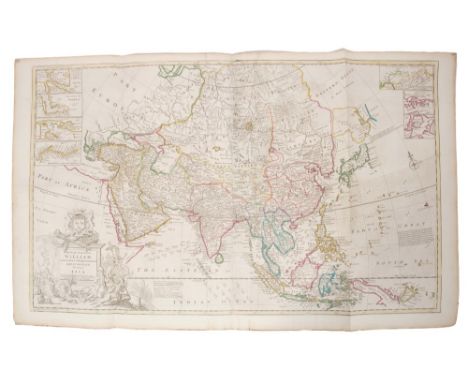
Lot 1081

Guijelmus Blaeu (1571-1636) engraved map - ‘India Orientalis et Insulae Adiecentes’, 27 x 34cm

Lot 1056

Samuel Dunn (d 1794), hand-coloured map - ‘Africa and its several regions', published Laurie & Whittle, 1794, 33cm x 46cm.Condition report: Minor stains to margins, basically good

Lot 1025

Nicolas Sanson (1600-1667), hand-coloured map - ‘Partie Meridionale de l’Inde’, dated 1654, 38cm x 52cm.Condition report: Browning at periphery, small tear at top crease, marks to margins but generally good condition

Lot 1045

Jan Wolters (17th century), engraved map - ‘Indiae Orientalis Insularum Adiacentium’, 1697, 22cm x 27cm.Condition report: trimmed at margins, patch repairs at margin, foxing.

Lot 990

Herman Moll (d. 1732), large hand-coloured map - ‘Asia’, presentation to William, Lord Cowper, Lord High Chancellor of Great Britain’, printed – D. Midwinter, Thomas Bowles, Philip Overton, 1717, 58cm x 97cm.Condition report: cresases, small tears to border. Water stain to lower edge

Lot 958

Jan Van Braam (18th century), engraved map - ‘Kaart der Zuyd-Wester Eylanden van Banda’, 1724, 34cm x 47cm.Condition report: time staining but generally good

Lot 1069

Herman Moll (d. 1732) hand coloured map - ‘The East Part of India’, 26 x 16cm

Lot 1068

Herman Moll (d. 1732) hand coloured map - ‘The Philippine Islands and others of the East Indies’, 18 x 26

Lot 997

Thomas Kitchin (1718-1784), hand-coloured map - ‘Asia / From the best authorities’, 18cm x 23cm.Condition report: good condition

Lot 1059

John Senex (d.1740), hand-coloured map - ‘A New Map of Asia’, 1721, 50cm x 59cmCondition report: Few tape repairs to margins, damage to corners, generally good

Lot 1037

Isaak Tirion (d.1769), hand-coloured map - ‘Nieuwe Kaart van Asia’, 28cm x 36cm, 1740Condition report: Trimmed margins, minor marks, generally ok

Lot 1073

Henry Abraham Chatelain (1684-1743), engraved map - ‘La Royaume de Siam...’, 38 x 44cm,

Lot 986

Gerhard Mercator (1512-1594), engraved map - ‘India Orientalis’ (J.Hondius 1609), Latin text verso, 36cm x 48cm.Condition report: Generally good

Lot 1067

Herman Moll (d. 1732) hand coloured map - ‘The Principle Islands of the East Indies’, 18 x 26Condition report: Minor time stains, generally good

Lot 1019

John Ogilby (1600-1676), engraved map - ‘A new map of Asia’, F. lamb sculpt. 1673, 41cm x 52cm.Condition report: a little staining, deterioration lower left corner, two tape repairs to top edge,

Lot 1034

Nicholas Sanson (1600-1667, hand coloured map ‘Insulae Moluccae’, 1720, 19 x 25cmCondition report: Couple of tape repairs or tears, small tear to border, minor marks

Lot 1020

Tomasso Poracchi (1539-1585), hand-coloured map with accompanying Latin text - ‘Descrttione Dell’Isole Molucca’, 1572, image 11cm x 15cm.Condition report: good

Lot 1089

George Moritz Lowitz (1722-1774) hand coloured map ‘Cart hydrographique & chorographique des Isles Philippines’, circa 1750, 97 x 53cm

Lot 977

William Herbert (1718-1795), hand-coloured map - ‘A correct Chart of The China Seas...’, 1758, 59cm x 77cmCondition report: Tape top spins, patch along top edge. General staining

Lot 1012

Herman Moll (d. 1732), large hand-coloured map - ‘A map of East Indies.... to Ye Directors of Ye Hon.ble United East- India Company’, 1717, 62cm x 101cm.Condition report: A couple of tears from margins, tape repairs to margins arresting other tears, otherwise minor disrepair commensurate with age

Lot 1093

Jan Jansson (1588-1664) hand coloured map - ‘Alsatia Inferior’ published Amsterdam, circa 1640, 36 x 43cm, glazed frame

Loading...Loading...
  • 109182 item(s)
    /page

Recently Viewed Lots