We found 109182 price guide item(s) matching your search
There are 109182 lots that match your search criteria. Subscribe now to get instant access to the full price guide service.
Click here to subscribe- List
- Grid
-
109182 item(s)/page


Lot 216
1920s/30s London independent bus operator MAPS/GUIDES comprising City Motor Omnibus Map & Timetable No 2 1925 for service 536A 'The All Brown Route' between Highgate and Southend Village/Farnborough and Birch Bros Map-timetable-guide dated 1931 for route 231 between Hampstead Heath and Harlesden. Both in lightly-used but good condition. [2]


Lot 235
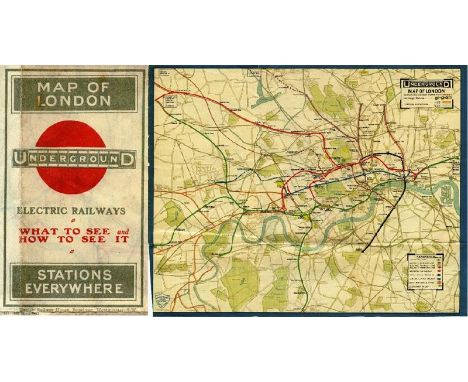
1909 London Underground MAP -'What to see & how to see it - The Excursionist's Guide with Map'. This was the first issue to dispense with the streets background, resulting in a much clearer image, and also one of the first to use the famous UndergrounD logo. It was aimed at the leisure market with numbers referring to listed places of interest. A small scuff near the top edge but generally very good. Has been re-folded. [1]
Lot 242
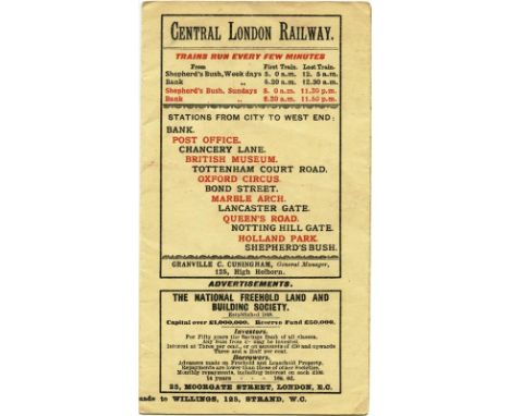
1902 Central London Railway fold-out MAP produced by the "Tuppenny Tube" to promote its service from Bank to Shepherds Bush. The line is superimposed in red on a street-map background and shows the generating station and depôt at the western end with an inset plan of the subways at Bank on the top right. The reverse has travel and ticket information. A lightly-used but very reasonable copy. [1]

Lot 245
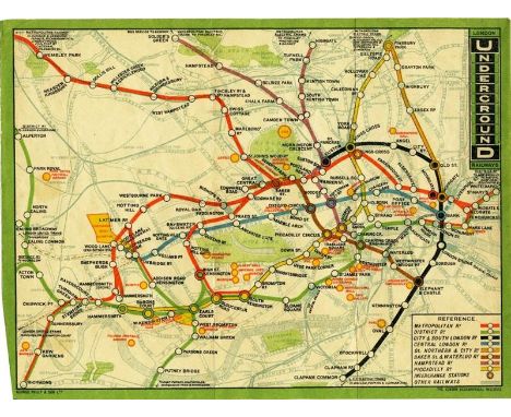
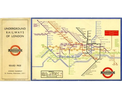
Collection of London Underground EPHEMERA comprising June 1927 'Stingemore' MAP (good), 'Beck' MAP no 1, 1945 (good), 4 further MAPS 1949-65, 1953 COLLISION REPORT Stratford Central Line, Easter 1963 District Line TIMETABLE NOTICE, 4 x CAR LINE DIAGRAMS (used condition, scruffy) and a modern double-royal POSTER for Travelcards. [13 items]


Lot 257
1905 London County Council MAP OF THE RIVER THAMES 'shewing the Steamboat Piers...', a fold-out map in good condition inside very worn covers (front piece detached) together with accompanying GUIDE TO THE COUNCIL'S RIVER STEAMBOAT SERVICE, a 78pp booklet with fares, names of steamers etc. In used condition, outer cover looks to be missing. Both publications dated June 1905 and very unusual indeed. [2
Lot 265
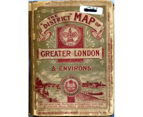
District Railway MAP OF GREATER LONDON & ENVIRONS, 1st edition dated 1902. A large-scale, fold-out map, paper on canvas inside hard covers. This series of District Rlwy maps ran from 1902-1908. In well-used condition with some wear to the covers and small labels on and inside the front cover. The map is generally good apart from a fold-parting in one of the panels.


Lot 283
London General Omnibus Company MAP & GUIDE TO OMNIBUS SERVICES dated September 1912, from the second year of issue of the classic London bus map which ran from March 1911 until 1994. Features an illustration of the famous B-type bus on the cover. In rather fragile condition with some fold-partings. [1]
Lot 288
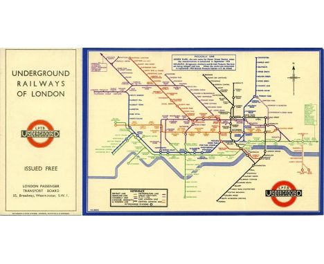
First-year edition of the BECK UNDERGROUND MAP 'Underground Railways of London", this being the undated edition without a print-code issued in approx August 1933 with mention of the reconstructed & re-named stations at Green Park and Holborn opening in September that year. A fold-out card map with some creasing but otherwise unmarked and good. [1]


Lot 299
c1909 London Underground MAP issued independently by the Central London Railway but using a standard London Electric Railways map on one side with the CLR's own map and information on the reverse. This is the earlier version of this map which does not yet show the CLR extension to Liverpool Street under construction. In good, lightly used condition with a strip of paper & adhesive on the central spine on the reverse, not affecting any content. A scarce map. [1]


Lot 307
1932 London Underground MAP OF LONDON'S UNDERGROUND RAILWAYS, the last of the Stingemore-designed series which ran from 1925 until 1932. Linen-card map with mustard cover in the larger size of the later editions and showing the completed Piccadilly Line extensions with dates of opening on the reverse. It is in lightly-used condition with some cover staining. [1]
Lot 32
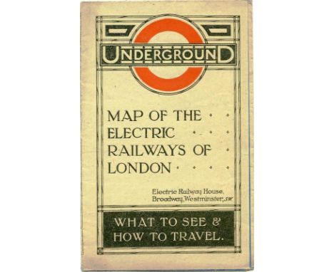
1919 London Underground MAP OF THE ELECTRIC RAILWAYS OF LONDON 'What to See & How to Travel' with print-code 395-500M-2-10-19. Has the red, open, bullseye circle on the cover and opens out in 8 panels to 13.7" x 10.9" (34 x 28cm). In very good, unmarked condition with just minor age-darkening in places. [1]


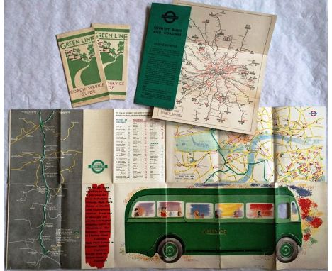
Lot 337
Collection of Green Line Coaches EPHEMERA comprising two copies of the first edition of the COACH SERVICE GUIDE dated 27.4.31 (light foxing), featuring a map of Poland St Coach Station, a 1936 fold-out illustrated PAMPHLET (used condition) 'See London at its best' with a central London map and featuring an illustration of a T-type coach and two issues (1936 & 1958) of the linen-card MAP issued to coach crews in case of breakdowns (good condition). [5]

Lot 342
LCC Tramways pocket-sized "MAP & GUIDE TO CAR SERVICES" dated July 1913. Illustrated with a cover picture of a tram by Cleopatra's Needle. Contains 2 folded LCCT leaflets on cheap return fares and band performances in parks. Lightly used with a little cover-staining but otherwise a good example. [1]
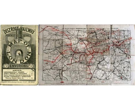
Lot 346
1902 District Railway 'POCKET REFERENCE MAP OF LONDON & ENVIRONS' with cover illustration of steam train in tunnel with motto 'Time is money'. Map shows extension to Uxbridge etc as dotted line. Opens out to 17" x 11" (44cm x 28cm). In used condition with wear and short fold-partings, one panel repaired with archive tape. A scarce issue. [1]

Lot 348
Original 1934 London Transport quad royal POSTER MAP of 'All Routes - Road & Rail' including buses, trams, Underground and main-line railways, possibly the first issue showing the whole LPTB operating area. These would have been posted at selected bus and Underground stations, enquiry offices etc. Has been stored folded and has some short fold-partings in places and scuffed edges. A very scarce item. [1]

Lot 354
1914 London Underground MAP OF THE ELECTRIC RAILWAYS OF LONDON 'shewing connections with the Great Central Railway at Marylebone'. Opens out to 16.5 " x 13" (42cm x 33cm) with 12 panels. Undated but mid-late 1914. Circle of bullseye on cover is red. Small loss at top edge and minor fold-parting but overall a good example. [1]
Lot 365
1912 London Underground Railways MAP printed by George Philip & Son Ltd and featuring the vertical UndergrounD logo. This issue marks stations with black-outlined white circles and shows the Met station at Hammersmith (Grove). A single-sided map ex-guidebook with small printer's cutaway at lower left-hand edge. In very good condition. [1]

Lot 371
1921 'Inner Area MAP of the Electric Railways of London', a pocket-sized linen-card issue designed by MacDonald Gill using his own personalised style of calligraphy for the station names and key box text. Very slight wear to the covers but a firm and crisp example in very good condition. [1]

Lot 373
1934 London Transport quad royal POSTER MAP of Green Line Coach & Country Bus Routes, thought to be the first issue. These were posted in bus shelters, at bus and Underground stations etc. A unique map in that there was no equivalent pocket-sized issue. Has been stored folded and has some edge scuffs/splits and a couple of fold-corner partings but still displays well. Very scarce. [1]


Lot 388
c1931 London Underground MAP OF LONDON'S UNDERGROUND RAILWAYS, one of the Stingemore-designed series which ran from 1925 until 1932. Linen-card map with blue cover in the larger size of the later editions and showing the Piccadilly Line extensions to Cockfosters, Sudbury Town and Northfields as under construction. It is in unmarked, lightly-used condition with a horizontal crease. [1]

Lot 390
London General Omnibus Company MAP & GUIDE TO OMNIBUS SERVICES dated September 1911, the 7th issue of the famous London bus map which ran from March 1911 until 1994. An early issue with the illustration of the B-type bus on the cover. In well-used condition with scuffing and damage along one edge although very reasonable in other areas! [1]
Lot 397
First-year edition of the BECK UNDERGROUND MAP 'Underground Railways of London", this being the undated edition with print-code 33-2791 issued in approx September 1933 and showing the escalator connection between Bank and Monument stations. A fold-out card map in lightly-used, unmarked condition. [1]

Lot 400
London Underground 1922 MAP OF THE ELECTRIC RAILWAYS OF LONDON - WHAT TO SEE AND HOW TO TRAVEL. Edition dated 1-3-22. Designed by MaDonald Gill, this attractive map uses calligraphy for the station names and features a decorative border. The map opens out to 13.5" x 11" (34 x 28cm). A couple of small, light stains but generally a very good example. [1]
Lot 5
First-year edition of the BECK UNDERGROUND MAP 'Underground Railways of London", this being the undated edition without a print-code issued in approx August 1933 with mention of the reconstructed & re-named stations at Green Park and Holborn opening in September that year. A fold-out card map in excellent condition. [1]

Lot 57
1912 Underground MAP: Central London Railway 'Liverpool & Broad St Stations now open' promoting the 'connecting link between East and West' and the connections with the Great Eastern Railway. Shows the extension from Wood Lane to Ealing as under construction. Opens out to 14" x 11" (36" x 28"). In well used condition with wear and fold-partings. An unusual issue. [1]

Lot 61
London Underground quad royal POSTER MAP 'The London Underground' dated 1978 and designed by Paul Garbutt. Shows the Jubilee Line under construction from Baker St to Trafalgar Square. Has been stored folded and has a small hole near the top edge (outside the map) but is otherwise in good condition. [1]

Lot 62
1910 LCC TRAMWAY MAP of London and Suburbs 'showing the LCC Tramways and their connections with other tramways and tube railways'. A fold-out linen-backed map inside linen-card covers produced by G W Bacon & Co Ltd 'under the direction of the London County Council', the map pre-dates the LCC's own issues. Shows the whole County of London area. Name on cover, a little damp-staining at the top but generally good. A very scarce issue. [1]


Lot 81
1887 District Railway "COUNTRY MAP OF THE ENVIRONS OF LONDON", a series which ran from 1883 to 1898. Pocket-sized, linen-backed map inside hard covers with many illustrations of London sights. The map (13" x 16.5" - 33cm x 42cm) shows counties in different colours and the DR connections with the Metropolitan and main-line railways, reaching to St Albans in the north and Dorking in the south. Some wear to covers but a very reasonable copy of this scarce issue. [1]

Lot 83
PERSONAL SCRAPBOOK (with his monogram on cover) of H (Harry) C Beck, designer of the famous London Underground map. 29 double-sided pages containing a wide variety of items special to him, eg cartoons, tube maps, drawings, sketches of self and Fred Stingemore, family photos (incl wedding) and correspondence, LT rejection letter, design for Underground timetable cover etc etc. A truly historic mini-archive. [1 with multiple contents]
Lot 87
1913 official UNDERGROUND MAP OF LONDON, "What to see and how to see it". Print-code: 187-150 M-1-6-13.This is the map shown on p59 of Capital Transport's "No need to ask" reference work and shows the planned extensions of the Bakerloo, Central and Hampstead Tubes. The cover features one of the first printed versions of the bullseye logo, forerunner of today's roundel. Ex-guidebook issue with small edge-trim. Light wear but generally good. [1]
Lot 92
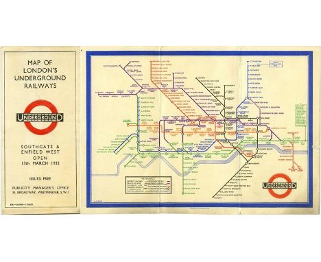
2nd edition of the Harry Beck London Underground diagrammatic, fold-out MAP issued in February 1933 with print-code 376-20,000-17-2-33. This is the special version relating to the opening of the stations at Southgate and Enfield West. This was a limited print-run and this is a scarce issue. A little light wear but overall in very good condition [1]


-
109182 item(s)/page