We found 109182 price guide item(s) matching your search
There are 109182 lots that match your search criteria. Subscribe now to get instant access to the full price guide service.
Click here to subscribe- List
- Grid
-
109182 item(s)/page


Lot 381
TWO BOXES AND LOOSE PRINTS etc, to include a signed David Dipnall print 'Memories of Summer Days' framed, approximate size 46cm x 53cm, signed Rex Preston framed print, signed Donald Ayres print, John Player 'Cricketeers 1938' full set - framed, Ken Arrowsmith watercolour of a rural scene, together with a quantity of framed prints and photographs on a variety of subjects - flowers, impressionists etc and a Robert Morden map of Nottinghamshire, largest framed print approximately 61cm x 94cm including frame
Lot 388
PAINTINGS AND PRINTS ETC, to include 'Ted Battersea Saint Denoeux, France', a watercolour of a French village, approximate size 51cm x 71cm, with a pen and wash sketch of the same scene, approximate size 24cm x 33cm, watercolour of a church by R.W.Bardsmore, photographic print of Trinity College Cambridge, Rugby 1st XI, dated 1910, together with assorted prints, box canvas prints, photographs and maritime map 'Islay to Ardnamurchan'


Lot 61
Map of North America by Richard W. Seale, printed by William and Cluer Dicey at ye Printing Office in Bow Church Yard London, A New Map Of North America, wherein is exactly described all ye European Settlements, with whatever else is remarkable in the WEST INDIES, from the latest and best Discoveries; Adorn'd with Views and Plans of the most considerable Towns, Harbours, &c., 1755.Condition report: The map is missing the views and plans which originally ran down both sides of the map. The map is laid down and there are numerous tears and losses and heavy staining across the map.

Lot 63
Lancashire. Speed (John), The Countie Palatine of Lancaster described and divided into Hundreds, Thomas Bassett & Richard Chiswell, [1676], hand-coloured engraved map, inset town plan of Lancaster, English text on verso, together with two later maps of Lancashire and Derbyshire.plate size 38.5cm x 51.5cm (15.25in x 20.25in)Qty: 3Condition report: The map is in very good, original condition with only very light time staining and yellowing around the edge of the paper near the mount board. The maps are all framed and glazed.

Lot 64
Two early maps of Cheshire to include "CHESTER" (Cheshire) by Pieter Van Den Keere ('Miniature Speed') c.1627/1646 and "A Map of Cheshire, North West from London" by T. Badeslade / W. H. Toms, published Sep 29, 1742, hand coloured engraved maps.9cm x 12.5cm (3.5in x 5in) and 16cm x 17cm (6.25in x 6.75in)Qty: 2Condition report: The maps are both in good, original condition. There is the odd minor spot of foxing and browning across the maps. The maps are both framed and glazed. The frames have some minor scuffs and scratches commensurate with age.


Lot 84
Lewis's Topographical Dictionary of England and Wales, comprising a General Map of England and Wales, a Plan of London and Maps of the Counties, published London, 1848.Condition report: The Dictionary appears to be complete with all maps present. There is some minor foxing throughout and some minor tears where the maps attach to the book as can be seen on the first two large maps in the book. The bindings has scuffs and losses most notably to the bottom edge as can be seen in the images.
Lot 326
ANTONIO DE SOLIS: HISTOIRE DE LA CONQUESTE DU MEXIQUE OU DE LA NOUVELLE ESPAGNE..., Paris, Guillaume Cavalier, 1704, vol 1 (of 2), engraved folding map, 10 plates including 8 folding, contemporary calf worn + LAURENCE STERNE: THE SELECT WORKS, Vienna for R Sammer, 1798, vols 7-9 (of 9), vols 7-8 "LETTERS" in 2 vols complete, vol 7 portfrontis, vol 9 THE KORAN, complete, 12mo, contemporary half calf worn + VOLTAIRE: ROMANS ET CONTES, Lyon, 1790, vol 3 (of 6), title page small part excised not affecting text, engraved frontis, 12mo, contemporary calf worn, armorial book plate of Richard Cavendish, 2nd Baron Waterpark (1765-1830) + THOMAS TOMPKINS "E TOMPKINS": POEMS ON VARIOUS SUBJECTS..., Oxford, 1800, 12mo, contemporary calf worn, top board and ffep detached + WILLIAM SHAKESPEARE: THE SONNETS, London and New York, John Lane, 1902, "The Lovers Library", 12mo, original decorative vellum gilt, all edges gilt (7)


![ROBERT MORDEN: SHROPSHIRE, engraved hand coloured map [1695], approx 350 x 420mm, framed and glazed + MOULE: LEICESTERSHIRE,](https://cdn.globalauctionplatform.com/4a854804-88b3-476d-bc1c-ac4b0110a665/e2ccf006-7238-4306-92c2-ac4f00b33ebf/468x382.jpg)


Lot 431
THE QUR'AN, AN INTERPRETATION BY MARMADUKE PICKTHALL, London, The Folio Society, 2010, 4th printing, original decorative cloth, top edges gilt, slip-case + SIMON ARMITAGE (TRANS): SIR GAWAIN AND THE GREEN KNIGHT, ill Diana Sudyka, London, The Folio Society, 2008, 1st Folio Society edition, 4to, original pictorial cloth, slip-case + SCOTT D WESTREM: THE HEREFORD WORLD MAP, London, Folio Society, 2010, 1st Folio Society edition, original decorative cloth gilt, slip-case + CHRISTOPHER ISHERWOOD: MR NORRIS CHANGES TRAINS, ill Beryl Cook, London, Folio Society, 1990, 1st Folio Society edition, rebound, decorative half crushed green morocco, marbled boards, spine gilt in compartments (4)
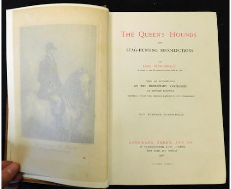
Lot 452
THOMAS LISTER, LORD RIBBLESDALE: THE QUEEN'S HOUNDS AND STAG-HUNTING RECOLLECTIONS, London, New York and Bombay, Longmans, Green & Co, 1897, 1st edition, signed and inscribed and dated by [Sir] Charles [Clow] Tennant (1823-1906) to William Hay, 10th Marquis of Tweeddale (1826-1911), his armorial book plate on front paste down, 25 plates, folding map at end, original buckram gilt worn and soiled, top edges gilt

Lot 463
ALFRED THAYER MAHAN: TYPES OF NAVAL OFFICERS DRAWN FROM THE HISTORY OF THE BRITISH NAVY, Boston, Little, Brown & Co, 1901, 1 vol in 2, preface dated October 1901, 7 plates as list, extra illustrated specially printed added title pages "Extra illustrated by Charles E Goospeed, Boston 1909", 167 additional plates (mainly ports) and a folding map of the British Channel together with some autographed letters and documents including letter of 1696 endorsed at foot by Sir George Rooke (1650-1709), document of 1704 endorsed by George Byng, 1st Viscount Torrington (1663-1733), letter of 1783 signed by Augustus Keppel, 1st Viscount Keppel (1725-1786), document of 1768 signed by Alexander Hood, 1st Viscount Bridport (1726-1814), 1809 autograph testimonial signed by Cuthbert Collingwood, 1st Baron Collingwood (1748-1810), undated autograph letter signed by George Elphinstone, 1st Viscount Keith (1740-1823), 1824 autograph letter signed by Edward Pellew, Viscount Exmouth (1757-1833) etc, crushed crimson morocco gilt, spines gilt in compartments, top edges gilt by Riviere & Son (2)

Lot 466
JAMES STANIER CLARKE & JOHN M'ARTHUR: THE LIFE AND SERVICES OF HORATIO VISCOUNT NELSON, London, Fisher Son & Co, [1839-40], 2nd edition, 7 divisions complete, 3 added engraved titles, 36 plates including folding map, margin of one plate in 5th division cropped, original blind stamped ribbed cloth gilt, re-cased, new end papers (7)

Lot 476
JAMES STANIER CLARKE & JOHN M'ARTHUR: THE LIVES AND SERVICES OF HORATIO NELSON, DUKE OF BRONTE, VICE-ADMIRAL OF THE WHITE ETC FROM HIS LORDSHIPS MANUSCRIPTS, London, Fisher Son & Co, [1839-40], 36 original parts complete, 3 added engraved vignette titles, 36 plates including folding map, original pictorial wraps to parts 1-4, 6-36, part 5 lacking top wraps, housed in 3 modern blue cloth book boxes, morocco gilt spine labels, very scarce in the original parts

Lot 501
EDWARD PELHAM BRENTON: A NAVAL HISTORY OF GREAT BRITAIN FROM THE YEAR MDCCLXXXIII TO MDCCCXXII, London, printed by J F Dove for C Rice, 1823-25, 1st edition, 5 vols, 13 engraved ports, 10 aquatint views, folding map, 3 battle plans including one folding, 2 folding charts, 2 folding plans, 2 tables including one folding facsimile letter as called for, old calf rebacked morocco gilt, spine labels, all edges marbled, armorial book plates of George Edward Towrey (5)

Lot 502
JAMES STANIER CLARKE & JOHN M'ARTHUR: THE LIFE AND SERVICES OF HORATIO VISCOUNT NELSON, DUKE OF BRONTE, THE VICE-ADMIRAL OF THE WHITE, KB ETC FROM HIS LORDSHIP'S MANUSCRIPTS, London, Fisher Son & Co [1840], 3 vols, added engraved vignette titles, 37 plates including folding map, old half green morocco gilt, spines gilt in compartments, top edges gilt, armorial book plate of Frederick Symonds, (3)
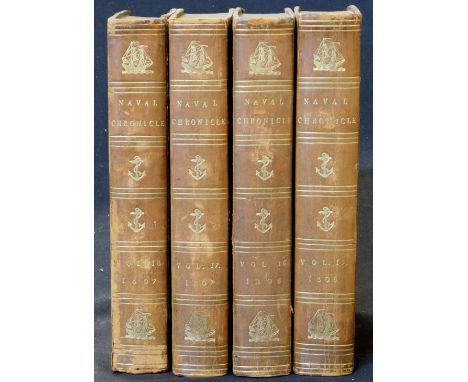
Lot 547
THE NAVAL CHRONICLE..., 1806-07, vols 15-18, vol 15 12 (of 13) plates including added title "Funeral car", plate portrait of Capt George Duff with long closed marginal tear, lacking the plate "View of the Royal Naval Academy", vol 16 14 plates as list including added title, vol 17 13 plates as list including added title and folding map, vol 18 13 plates as list including added tile, old half calf marbled boards, spine gilt in compartments, armorial book plates of Hon Frederic Noel, RN (post-captain of 1819) (4)

![[FAVELL LEE MORTIMER]: FAR OFF PART II OCEANIA, AFRICA AND AMERICA DESCRIBED..., London, Longmans, Green & Co, 1893, 3rd](https://cdn.globalauctionplatform.com/4a854804-88b3-476d-bc1c-ac4b0110a665/dd6d0856-a7c3-4cda-83c5-ac4f00af4db4/468x382.jpg)


Lot 582
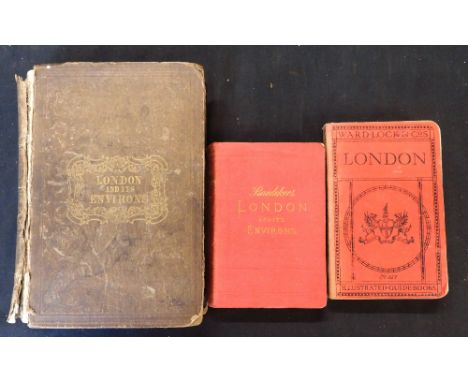
WILLIAM GRAY FEARNSIDE & THOMAS HARRAL (EDS): THE HISTORY OF LONDON ILLUSTRATED BY VIEWS IN LONDON AND WESTMINSTER, [1838], added engraved title, 29 plates, bound in at end WILLIAM EDWARD TROTTER: SELECT ILLUSTRATED TOPOGRAPHY OF THIRTY MILES AROUND LONDON..., London, The Proprietor, circa 1839, added engraved vignette title, plates collated complete but lacking map, original blind stamped cloth gilt, v worn and soiled, top board detached, requires re-binding + K BAEDEKER: LONDON AND ITS ENVIRONS, 1879, 2nd edition, maps and plans complete, original cloth gilt, split at spine + A PICTORIAL AND DESCRIPTIVE GUIDE TO LONDON..., London, Ward Lock, ND, 48th edition revised, original limp cloth (3)

Lot 595
FRANCIS BLOMEFIELD AND CHARLES PARKIN: AN ESSAY TOWARDS A TOPOGRAPHICAL HISTORY OF THE COUNTY OF NORFOLK, London, William Miller, 1805-10, 2nd edition, 11 vols, mezzotint frontis, 2 folding plans, folding map, 33 plates as called for, 14 pedigrees, extra illustrated with full set of 64 lithoplates from FRANCIS STONE: PICTURESQUE VIEWS OF ALL THE BRIDGES BELONGING TO THE COUNTY OF NORFOLK 1830, old half calf worn


Lot 3580
Glover, Stephen. The History and Gazetteer of the County of Derby, in two volumes, Derby: Henry Mozley and Son, 1831-33, featuring folding map frontispiece, rebound in tan cloth lettered in gilt. Together with History, Gazetteer and Directory of Derbyshire, by Samuel Bagshaw, Sheffield: William Saxton, 1846, publisher's cloth with tape reinforcing spine (3)
-
109182 item(s)/page