We found 109198 price guide item(s) matching your search

Refine your search

Year

Filter by Price Range
  • List
  • Grid
  • 109198 item(s)
    /page

Lot 89

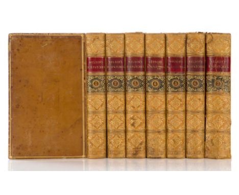
NICOLAS, SIR NICHOLAS HARRIS, ED., 'THE DISPATCHES AND LETTERS OF LORD VISCOUNT NELSON', 7 vol. engraved portrait, folding engraved map, folding lithographed map, a lithographed plan and 3 folding facsimiles, portrait foxed and offset on to the title, contemporary polished calf by W. Nutt, gilt spines with red and black labels, double gilt border round sides, marbled edges, vol. VII lacks front cover, a few spines very lightly rubbed, 8vo, London, 1844-46; together with another (8), ~Nicolas~s great 1844/6 opus~ Mariner~s Mirror, p.466.

Lot 90

CLARKE, JAMES STANIER & JOHN M'ARTHUR, ' THE LIFE AND SERVICES OF HORATIO VISCOUNT NELSON', 3 vol., additional engraved titles, 21 portraits, folding engraved map and 13 plates, a little light foxing, later 19th century half cloth, gilt spines, black labels gilt, a few very slight signs of wear, armorial bookplate of Robert Gregson Gorton, bookseller~s label, 8vo, London c1850 (3)

Lot 214

Reproduction SAXTON'S map of England and Wales, 1579, printed by Taylowe Ltd, 1966

Lot 582

A MAP OF WILTSHIRE 'England Depicted in a Series of Splendidly Full Coloured Maps', Series No. 38, pub. Collins, 22 Paternoster Row and other ephemera

Lot 637

A 19TH CENTURY COLOUR LITHOGRAPH OF COLOGNE, other prints and a map of Somerset

Lot 587

An F Barker & Son Service Prismatic Compass Mk VIII, No. 644, dated 1910, marked the inside of the lid 2020, with brown leather carry case, together with a Manual of Map Reading, Photo Reading and Field Sketching by the War Office, dated 1929, of which the compass appears (3)

Lot 588

A J.H. Steward Prismatic Compass, the brass body undated, having luminous dial and large black arrow, with a brown leather carry case by L.F. & Co, dated 1916, together with a Manual of Map Reading and Field Sketching 1912, this Edition is the re-print with additions 1914 (3)

Lot 620

Two WWII period maps, one of Iraq and the other Enfidaville, together with three later maps, a Panzerarmee Afrika 1943 Kalender, a Soldier's Guide of Italy booklet, plus other ephemera (parcel)the Enfidaville map is 1:50000, sheet 43, reproduced by 517 Corps Field Survey Coy R.E April 1943, folded and rolled, some water staining and tears, please see additional images

Lot 915

A collection of 19th century pictures and prints including a needlework alphabet sampler, 24 x 22cm in burrwood frame, a pair of sporting prints each composed of four subjects showing horse racing and shooting, both after Henry Alken, a map of Gloucestershire by John Kary and a map of the city of Gloucester by EW Bayley, a Stevengraph of a coaching scene, etc, various sizes all framed

Lot 450

2 framed and glazed prints and a map.

Lot 500

A framed and glazed map of New Zealand.

Lot 318

BROOKES MAP. A framed Brookes 'Travelling Companion through England and Wales.' A hand coloured engraved map published by William Darton, 58 Holborn Hill, London. With original cardboard packet.

Lot 319

FOLDING MAP. A Penwith Peninsula & Mount's Bay folding map, now framed & glazed. 44 x 55cm.

Lot 320

SOVIET MAP. A school map from the Soviet era. 115 x 175cm.

Lot 609

MOTORING PUBLICATIONS.Four items: 'Motorists Handbook', The Motor Training Institute, 5th edition; Lucas Booklet No. 219c 'Running Instructions for the Electric Lighting & Starting Equipment; 'I Wish I Knew More About...' from the Vacuum Oil Co. USA 1929 & a complimentary 'Motorists Road Map' by ROP Zip Motor Oils .

Lot 611

MOTORING ROAD MAPS ETC.Two sets of road maps: 'The Autocar Sectional Road Map of England & Wales' & 'Daily Mail Milestone Motor Map'. Also a 1905 'The Autocar Advertising Supplement' & a 1922 '16th International Motor Exhibition Supplement'.

Lot 612

MOTORING MAPS ETC.Nine early 20th century folding motoring maps including two AA, a Dunlop, a Michelin & five others. Plus an Ordnance Survey & Bartholomew's map (11).

Lot 613

MOTORING MAPS ETC.Five early 20th century folding motoring maps including two AA, an RAC, a Horlicks complimentary map, a Michelin map.

Lot 615

BARTHOLOMEW'S ROAD MAPS.A set of twenty-three Bartholomew's 'Automobile Map of Great Britain' quarter inch folding road maps in original leather case. Retailed by Sifton & Praed, The Map House, London. Includes original map measure & key. Case has wear & other damage

Lot 115

A WWII ERA MILITARY MAP CARRY CASE, in dark brown leather, with carrying handle and multiple pockets inside, also spaces for pens, pencils, etc, clasp is marked BREV SDGD Foreign Pats, inside lid is marked in pen to Lt. Willetts C.F. 331184 R, War Reg't

Lot 133

A SELECTION OF BOOKS OF A MILITARY WWI INTEREST FOR THE BATTLE OF SOMME, PASCHENDAELE, etc, to include Major Holts Battlefield guide to the Somme and Ypres Salient with map, four trench maps, Loos, Longueval, Thiepval Wood, Beaumont, Somme Day by Day account by Chris Mcarthy, Paschendaele Day by Day account by Mcarthy, The Somme 90 years on, Birmingham Pals by Terry Carter, Ulsters part in the Battle of The Somme (36th Div), the Tanks at Flers volumes 1 and 2 by Trevor Pidgeon

Lot 18

A framed and glazed coloured map of Dorset

Lot 85

A First Year in Canterbury Settlement by Samuel Butler, London 1863 with folding map

Lot 636

An Ambridge village map

Lot 409

A 19th century map of the roads within 14 miles of Tunbridge Wells, sold by J. Sprange, 44 x 43cm

Lot 413

C. Smith Publ. coloured engraving, Map of the County of Derby, 1801, 51 x 46cm and an earlier Map of Darbyshire, 11 x 14cm

Lot 427

Rock & Co Publ., engraving, illustrated map of Brighton and it's vicinity, 46 x 59cm

Lot 85

Darwin, Charles and others - Narrative of the Surveying Voyages of His Majesty's Ships Adventure and Beagle, vol I only, 8vo, original cloth - rubbed, spine faded, with large folding map of South America and another of The Straits of Magalhaens, inserted in an improvised front cover pocket, folding map of South America (torn) at p.462, London 1839

Lot 90

Hoskins, George Alexander - Travels in Ethiopa, quarto, cloth, with folding map (foxed), and 49 (of 54) litho plates (2 hand coloured and 4 chromolithos, front cover detached, spine ragged, some plates loose, lacking front fly leaf, London 1835

Lot 804

Superb Framed Print + Poster Collection : A distressed poster of a Gibraltar 1978 tour involving Birmingham Slovan and Zaragoza. 1978 Alan Ball Southampton signed print, A print of Old Trafford in 1958 (done in 2002) and a must see London Underground map from 2013 to celebrate 150 years of the FA with hundreds of stations all replaced with famous players. All framed. (4)

Lot 807

Crystal Palace 49/50 Football Autographs: Signed on blank inside page of the book Stanley Matthews Football Album. All but one of the 25 is identified on separate signature map.

Lot 85

1966 World Cup Football Headscarf: Stunning light blue with participating nations flags, Map of England, WC Willie and tournament logo. Immaculate and comes in original bag which has WC Willie sticker on it. Measures 26 x 26 inches.

Lot 223

Hand painted map of London in frame

Lot 14

A vintage boxed Universal map measurer, band ring made from a 1942 half crown coin and base metal compass

Lot 113

Cambell, J - Travels in South Africa [2nd Journey], 2 vols in 1, 8vo, rebound red morocco gilt, with folding hand-coloured map and 12 hand-coloured plates, some pages strengthened, London 1822

Lot 114

Drummond, W.H. - The Large Game and Natural History of South and South East Africa, green morocco, with colour frontis, title and 12 plates and map at rear, Edinburgh 1875

Lot 115

Freeman, Joseph John - Tour of South Africa, 8vo, half green morocco, joints split, with 1 map, torn (of 2) and 6 plates, London 1852

Lot 125

Paterson, W - A Narrative of Four Journeys into the Country of the Hottentots & Caffaria, 1st edition, folio, calf, with folding map (browned) and 17 plates (some spotted), London 1789

Lot 126

Sparrman Anders - A Voyage to the Cape of Good Hope, 2 vols, 1st English edition, quarto, burred calf, with 10 plates and folding map, London 1785

Lot 56

BOX CONTAINING QUANTITY VARIOUS TEA WARE, DECORATIVE JUG, OLD MAP BOOK, FLOWER BASKET, DECANTER ETC (BOX NOT INCLUDED)

Lot 1

A 17th Century Christopher Saxton and G. Hole hand coloured engraved map, Vniversi, Derbyshire, framed, 34 x 38cms

Lot 2

A 17th Century Christopher Saxton and Wilhelmus Kip hand coloured engraved map, Notingamiae, framed, 34 x 41cms

Lot 296

Cartography - seven maps to include The Provision of 1925 - 1926 provisional edition Lancashire sheet map of Glazebury printed and published by Director General of Ordnance Surveys Chessington Surrey 1947, Lancashire sheet edition of 1926 Culceth issued by the Ordnance Survey of Southampton, two divisional editions of Lancashire and Cheshire Rixton with Glazebrook issued by Ordnance Survey Office, a map of Lancashire Ince-in- Makerfield, Ashton-in-Makerfield and Ince issued by the Ordnance Survey Chessington Surrey 1965, a map of Lancashire and Chorley, Coppull, Wothington, Adlington issued by Ordnance Survey Chessington Surrey 1965, a map of Lancashire, Ashton-in-Makerfield, Haydock, Newton-le-Willows issued by Ordnance Survey Chessington Surrey 1956 and one further map of Helsington CP, Westmorland 1972 (qty)

Lot 345

Saxton (Christopher) & Hole (William)'Lancastriae', hand-coloured engraved map, framed and glazed; together with a reproduction map 'Eboracensis', framed and glazed; together with a collection of books & publications relating to cartography (qty)

Lot 353

Speed (John) 'Wilshire' John Sudbury & G. Humble, hand-coloured engraved map, framed and glazed

Lot 354

Kip (William) after Saxton (Christopher) 'Cumbria', hand-coloured engraved map, framed and glazed; together with five Victorian county maps, hand-colouerd, framed and glazed (6)

Lot 360

Jansson (J.) Cumbria Westmoria. vulgo Cumberland & Westmorland, nd. [c1646], hand-coloured engraved map, mounted, framed and glazed; Bowen (Eman.) A New Accurate Map of Scotland and North Britain..., nd [1747 or later], hand-coloured engraved map, mounted, framed and glazed

Lot 1183

A Silver Ruston & Hornsby Ltd 50 year service medal J E Graves 1900-1950 and a 50 year service badge and a Smith-Clayton Forge map of London.

Lot 1489

A double sided framed and glazed map, Market Rasen/Grimsby and Bridgford/Shelford, Lincolnshire.

Lot 1506

A box of large railway and steam locomotive photographs, a mounted Victorian photograph of Furness railway station and a 1901 railway clearing house map of the East of England

Lot 124

World War II Japan Interest - A British Commonwealth Forces black leather document folder enclosing War and Navy Department Chief of Engineers Washington D.C Japan road maps, numbered 140405, 1945; map 14040; and 141098 Korea (4)

Lot 784

MIXED WW2 EQUIPMENT; WW2 army gas mask bag, shell dressing bag, map case missing one stud, three pouches, belt and four sten magazines all in used condition. (11 items)

Lot 1693

17TH CENTURY MAP OF MONTGOMERYSHIRE BY JOHANNES BLAEUcirca 1654, hand coloured, 50.5cm x 60.5cm, mounted; along with a 17th century map of Scotland (2)

Lot 1694

18TH CENTURY MAP OF HUNGARY BY PETRUM SCHENKhand coloured, 53.5cm x 63cm; along with another map of Hungary; and five reproduction maps (7)

Lot 1695

18TH CENTURY MAP OF THE PROVINCE OF CALABRIA BY DOMENICO DE ROSSIcirca 1715, hand coloured, 62cm x 48cm, mounted

Lot 335

JACQUES NICOLAS BELLIN An 18th century French coloured map depicting The English Channel between Kent and Calais, being plate no.19 from Hydrographique Francaise, published between 1756 and 1765, 60cm x 88cm to plate mark, decoratively mounted in sl ender Hogarth style glazed frame

Lot 336

J. CARY - County Map of Kent, later hand coloured, 34cm x 51cm image size, glazed and framed, together with LIDALIA - The Scottish Borders by Timothy Pont, a Print, later hand coloured, published Joan Blaeu, probably early 17th century, 41cm x 52.5 cm to plate mark, open mounted and glazed with script verso, in slender hogarth style frame

Lot 337

CHRISTOPHER SAXON AND ROBERT MORDEN Two County maps of Warwickshire, later coloured, each in slender glazed hogarth style frame, together with a JOHN SPEED hand coloured County map of Gloucestershire, circa 1610, open mounted with script verso, in s lender hogarth glazed frame

Lot 1688

Boxed Chicihester Jig-saw Map Puzzles South East England to include No.5 & No. 6, unchecked

Lot 370

WILLIAM WHITE: HISTORY, GAZETTEER, AND DIRECTORY OF NORFOLK, AND THE CITY AND COUNTY OF THE CITY OF NORWICH, Sheffield, W White, 1845, 2nd edition, 814pp + [2]pp additions and alterations, lacks map, original blind stamped calf gilt, very worn, lacks large part backstrip + FRANCIS WHITE & CO: HISTORY, GAZETTEER, AND DIRECTORY, OF NORFOLK, AND THE CITY AND COUNTY OF THE CITY OF NORWICH, Sheffield, Francis White & Co, 1854, 1st edition, 881pp + 6pp adverts at end, original blind stamped calf gilt worn + KELLY'S DIRECTORY OF THE CITY OF NORWICH 1962-63, and KELLY'S DIRECTORY OF THE CITY OF NORWICH 1966, each original cloth (2nd title top board worn and soiled) (4)

Loading...Loading...
  • 109198 item(s)
    /page

Recently Viewed Lots