

Karel Anthony Nel (South African, born 1955)Cosmos inscribed 'Karel Nel/ 2011/ Cosmos: 259 Degree Field' (verso)sprayed pigment on bonded fibre paper55 x 210cm (21 5/8 x 82 11/16in).Footnotes:ProvenancePurchased at Art First, 2011.A private collection, UK.In 2004, Karel Nel was appointed as the resident artist on COSMOS - an ambitious project to map a two degree field of the universe. Working alongside a team of astronomers, Nel produced a series of pieces that were informed by the images and data collected from radio, x-ray, infrared and optical telescopes.This piece explores one of Nel's chief preoccupations: the visual and scientific conventions of representing vanishing points. He is fascinated by the way a vanishing point can determine a focal point, sidelining other objects to the periphery.Nel's medium is highly unusual, incorporating pastel, ochre, volcanic glass, sand and dust on a background of bonded fibre fabric. In 2012, Nel participated in the major exhibition African Cosmos, Stellar Arts: African Cultural Astronomy from Antiquity to the Present at the Smithsonian Museum of African Art.Nel's aesthetic fusion of scientific phenomena and artistic abstraction has been described by the South African poet, Stephen Watson, as an intellectual and spiritual investigation:'follow(ing) the trajectory of an inner journey, trawling amidst the rich multiplicity of the world's cultural traditions, their rites and symbols, searching for that imagery which might connect our conscious lives with the deepest spiritual potential within ourselves.' (1994)For further information on this lot please visit Bonhams.com
We found 108737 price guide item(s) matching your search
There are 108737 lots that match your search criteria. Subscribe now to get instant access to the full price guide service.
Click here to subscribe- List
- Grid
-
108737 item(s)/page


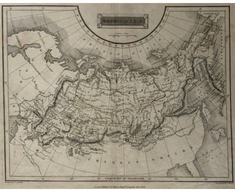
THIS IS A FINE 1826 MAP OF RUSSIA IN ASIA, DRAWN BY J. ASSHETON AND ENGRAVED BY J. SHURY. THIS BEAUTIFULLY DRAWN BLACK AND WHITE MAP COVERS THE ENTIRE AREA OF RUSSIA AND THE ADJACENT PARTS OF THE CHINESE EMPIRE. MAKES NOTE OF NUMEROUS RIVERS, MOUNTAIN RANGES, GULFS, SEAS, AND MAJOR CITIES. SCALE IS SHOWN IN THE UPPER CENTER QUADRANT. PUBLISHED BY THOMAS TEGG OF 73 CHEAPSIDE, LONDON. APP.SIZE:


The Great Bear by Simon Patterson. Framed and glazed. The Great Bear is a conceptual artwork by the British artist Simon Patterson. It is a copy of the 1991 London Underground map with the names of stations replaced by the names of famous cultural figures. Each Tube line represents a category of 'celebrity', including philosophers, footballers, engineers and comedians. Harry Beck's Tube map and the 'Great Bear' constellation, Ursa Major, are two familiar and easily accessible systems for ordering information. By adapting one and adopting the name of the other, Patterson's playful arrangement of the 'stars' challenges the authority and function of these systems.


Late Victorian wooden school room setting with bisque head teacher and six German all bisque pupils each seated at a combined desk and chair with slate board, in a classroom furnished with chest of drawers, fire-surround, lectern, wall map, pictures, miniature books, school bell, chalk board on easel, wall clock etc, L70cm H28cm D28cm - Condition Report


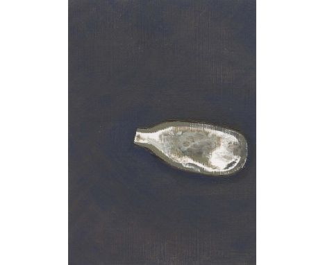
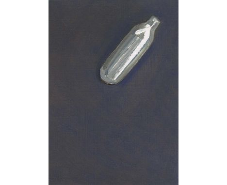
Andrew Torr NOX (LAT 51.4304 LON-0.1359), 2020 Oil on card Signed verso 15 x 10cm (5¾ x 3¾ in.) Andrew Torr lives and works in London. The recent subject and focus of his work are the city's open spaces at night. He is currently represented by the Northcote Gallery. These little, life-size, paintings began as a response to the vast amount of nitrous oxide bottles we see littering the streets and parks recently. The bottles are painted with as few marks as possible. The white areas are usually bare, primed canvas. This seems fitting - nitrous induces a very quick high and the bottles are discarded without a thought - it makes sense that these paintings are executed quickly. The titles come from the latitude and longitude that the bottle was found. These numbers can be entered into smart phone mapping and they will reveal where the bottle was discarded. It would be possible to map the positions of all these paintings which will trace Torr's own journey over the last few months. As with Torr's discarded beer can paintings, these studies are concerned with furtive activity and unknowable stories in the city. Coincidentally, they also share the same problems of rendering shiny, reflective surfaces - a great exercise for a painter.
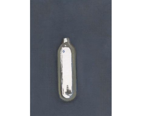
Andrew Torr NOX (LAT 51.4304 LON-0.1370), 2020 Oil on Card Signed verso 15 x 10cm (5¾ x 3¾ in.) Andrew Torr lives and works in London. The recent subject and focus of his work are the city's open spaces at night. He is currently represented by the Northcote Gallery. These little, life-size, paintings began as a response to the vast amount of nitrous oxide bottles we see littering the streets and parks recently. The bottles are painted with as few marks as possible. The white areas are usually bare, primed canvas. This seems fitting - nitrous induces a very quick high and the bottles are discarded without a thought - it makes sense that these paintings are executed quickly. The titles come from the latitude and longitude that the bottle was found. These numbers can be entered into smart phone mapping and they will reveal where the bottle was discarded. It would be possible to map the positions of all these paintings which will trace Torr's own journey over the last few months. As with Torr's discarded beer can paintings, these studies are concerned with furtive activity and unknowable stories in the city. Coincidentally, they also share the same problems of rendering shiny, reflective surfaces - a great exercise for a painter.
Andrew Torr NOX (LAT 51.4342 LON-0.1394), 2020 Oil on Card Signed verso 15 x 10cm (5¾ x 3¾ in.) Andrew Torr lives and works in London. The recent subject and focus of his work are the city's open spaces at night. He is currently represented by the Northcote Gallery. These little, life-size, paintings began as a response to the vast amount of nitrous oxide bottles we see littering the streets and parks recently. The bottles are painted with as few marks as possible. The white areas are usually bare, primed canvas. This seems fitting - nitrous induces a very quick high and the bottles are discarded without a thought - it makes sense that these paintings are executed quickly. The titles come from the latitude and longitude that the bottle was found. These numbers can be entered into smart phone mapping and they will reveal where the bottle was discarded. It would be possible to map the positions of all these paintings which will trace Torr's own journey over the last few months. As with Torr's discarded beer can paintings, these studies are concerned with furtive activity and unknowable stories in the city. Coincidentally, they also share the same problems of rendering shiny, reflective surfaces - a great exercise for a painter.
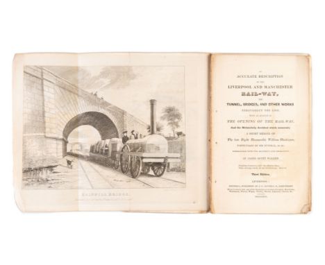
Walker (James Scott) An Accurate Description of the Liverpool and Manchester Rail-way..., third edition, 2 folding engraved plates by I.Shaw of Rainhill Bridge and Olive Mount, 16pp.advertisements at end, stitched in original printed wrappers, a little soiled and frayed at edges, wrappers detached with frontispiece, Liverpool, 1831 § Booth (Henry) An Account of the Liverpool and Manchester Railway, first issue, lithographed frontispiece, folding cross-section of the line (annotated) and a plate showing 'Rocket' and 'Novelty', presentation copy from the author inscribed to Mr Dixon on front free endpaper, ink stain to fore-edge of last few leaves, modern half red morocco, Liverpool, [1830]; another edition, second, larger format issue with folding map, lithographed frontispiece, plate and folding cross-section, contemporary ink signature of John Temperley to head of title, bookplate of Arthur Elton, modern half calf, Liverpool, [after 1833]; and a modern facsimile of Shaw's Views...of the Liverpool and Manchester Railway, 8vo & 4to (4)⁂ The first is generally regarded as the first railway guidebook. The first edition of 1830 had a map, the second a map and a plate, the third edition was considerably expanded, but the map dropped. The frontispiece shows a Stephenson engine of the Planet type. The Liverpool Manchester railway was the first to offer both passenger (No Smoking only) and freight.Henry Booth was Treasurer of the Liverpool and Manchester Railway. The larger format second issue of his work includes a map showing branch lines including the St. Helens Widnes line which was not built until 1833, the larger format was needed to avoid an horizontal fold on the map. This copy was owed by the railway engineer John Timperley, the first recipient of the Telford medal.
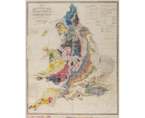
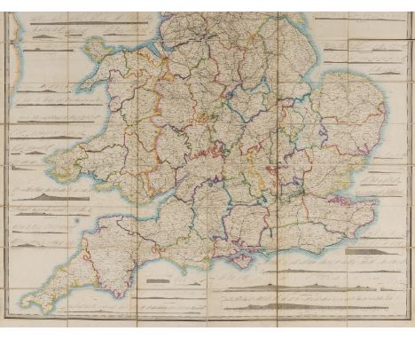
Walker (J. & C.) A Geological Map of England and Wales, showing also the Inland Navigation by means of Rivers & Canals, with their Elevation in feet above the Sea, later issue, large folding hand-coloured engraved map, c.1280 x 1040 mm., dissected and mounted on linen with green endpapers, some light offsetting, folding into original dark green cloth slip-case with pull-off top, red morocco label, rubbed, spine a little faded, 8vo, [c.1862].⁂ A handsome map in good condition, originally issued in 1835. The colourist depicting the rail routes seems to have taken a few liberties and omitted some of Cumbrian network. The line to Truro is shown complete therefore dating the colourist's efforts to the beginning of the 1860s.

Weinthal (Leo) The Story of the Cape to Cairo Railway and River Route, from 1887 to 1822, 3 volumes plus map and index volume, together 4 volumes (without the rare separately-published vol.5 supplement), maps, plates and illustrations, some mounted photographs, 12 folding maps in pocket in index volume, original half morocco, spines gilt, [Mendelssohn IV, pp.743-744], 4to, 1923-1925.
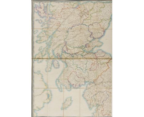
Wyld (James) Railway Map of England, Wales and Scotland...shewing the Lines of Railways with their Stations...the Inland Navigation, Great and Cross Roads, Cities, Market Towns & Villages, ?first issue, large folding hand-coloured engraved map in 4 parts, overall c.2060 x 1240 mm., dissected and mounted on linen with marbled endpapers, some light offsetting, folding into original cloth slip-case, printed label to upper cover (chipped), rubbed and faded, splits to joints, 8vo, Wyld, [pre-1847]].⁂ With the Central Scottish Railway to Perth marked as a prospect, and no marking for the Alloa branch. The Lancaster Carlisle line completed in 1847 is also shown as incomplete.
Wyld (James) Railway Map of England, Wales and Scotland..., ?second issue, large folding hand-coloured engraved map in 2 parts, overall c.2060 x 1240 mm., dissected and mounted on linen with cloth endpapers, some light offsetting, folding into original cloth slip-case, printed label to upper cover, rubbed and a little stained, splits to joints, 8vo, Wyld, [c.1855].⁂ This edition in rather stronger colour than the previous lot, and including the Central Scottish Railway to Perth with a branch to Alloa.

Bradshaw (George) Bradshaw's Railway Companion, folding map with route in red, 13 double-page maps/plans, some partly hand-coloured, original brownish cloth, glazed green label to upper cover, 1843; another edition, 2 folding maps, 14 double-page maps/plans, some partly hand-coloured, folding cross-section, original brownish cloth, glazed green label to upper cover, 1845; Lengths and Levels to Bradshaw's Maps of the Canals, Navigable Rivers, and Railways, in the Principal part of England, first edition, 1833; Lengths and Levels...from Actual Survey, 2 engraved maps on folding sheet, 1832 bound with Extracts from the Minutes of Evidence given before the House of Lords on the London and Birmingham Railway Bill, half-title, folding engraved map of Stephenson's survey, 1832, together 3 works in 1 vol., contemporary cloth, spine faded; Bradshaw's Shareholder's Guide, Railway Manual and Directory, for 1856, 2 large folding maps with plates of patented inventions on verso, one torn, contemporary maroon morocco with brass clasp, title and "G.Gamble Esq." in gilt to upper cover, spine gilt, remains of old label to head, rubbed, London & Manchester, 1856; Bradshaw's British Railway Guide..., No.182, folding map, illustrated advertisements, original printed wrappers, spotted, upper cover frayed and detached, 3rd Mo (March) 1849; and 13 others, Bradshaw, v.s. (18)⁂ The Lengths and Levels are often found bound together with the Extracts of Minutes. The London to Birmingham Company had their original Bill refused after several nimby peers objected. However, in 1833 the Bill was passed and work started later that year, by 1838 it was complete. The journey took five and a half hours.

America.- The American Revolution.- Howell (Reading) A Map of the State of Pennsylvania by Reading Howell, MDCCXCII To Thomas Mifflin Governor ... This Map is respectfully Inscribed by the Author, showing exact boundaries, including the western limits, from information Howell gathered from surveys made after the Revolutionary War, with numerous topographical details, towns, and roads, engraving, a good impression, 960 x 1630 mm (37 3/4 x 64 in), dissected and mounted on linen, some splitting to linen, a few edges curling, some spotting, browning and surface dirt, folding without slip-case, 4to, published 1 August 1792, for the Author, & Sold by James Phillips, George Yard, Lombard Street, London, 1792.⁂ "The best map of Pennsylvania to appear in the 18th century, and the first detailed map of the State to show its exact boundaries"(Wheat and Brun)
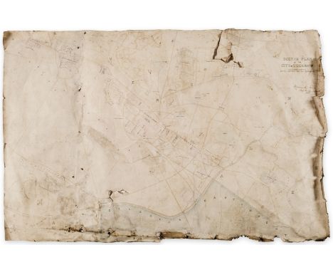
India.- Royal Bengal Engineers.- Sketch Plan of the City of Lucknow, large manuscript map of the capital of the state of Uttar Pradesh, pen and inks, watercolour wash, traces of pencil, on wove paper, sheet approx. 660 x 1000 mm (26 x 39 1/2 in), with owner's ink inscription of William Crommelin in the upper right corner, mounted on linen, several large tears within the map with some losses, numerous nicks and tears to extremities, surface dirt, damp-stains, unframed, [circa 1860]; together with a lithographed map by H.M Smith, No. 2 Plan of the Operations Against Lucknow during the month of March 1858, mounted on various [?]Indian handmade papers, old folds, some surface abrasion and adhesive issues, damp-stains and the lower right affixed with old paper obscuring the map, in general poor condition with numerous issues, unframed, published by Surveyor Generals Office Calcutta, 1858 (2)⁂ The manuscript map bears the collectors' signature of Major William Arden Crommelin, of the Bengal Engineers, later Chief Engineer of Oudh.
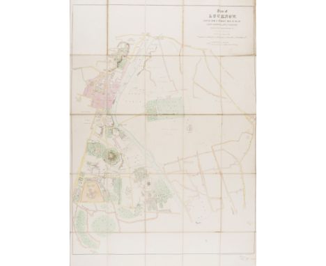
India.- Topographical Department (War Office) Plan of Lucknow, plotted from a survey made in 1856, by Lieut. Moorsom, 52nd. Lt. Infantry, lithograph with hand-colouring, 980 x 690 mm (38 3/4 x 27 1/4 in), dissected and mounted on linen, minor offsetting and browning, folding into red straight-grain morocco by 'Wickwar Binder London', gilt, upper cover decorated with Royal coat of arms and lettered 'Plan of Lucknow, some rubbing and minor scuffs, 8vo, 1856 ⁂ Fine copy of this scarce map produced a year or so before the start of the Great Mutiny of 1857.

Italy.- Swinburne (Henry) Travels in the Two Sicilies, 2 vol., first edition, half-title in vol.2 only, folding engraved map, 2 plans, 20 plates (2 folding) and one folding letterpress genealogical table, some foxing, short tear to map, bookplate of James Frampton, contemporary tree calf, gilt, a little rubbed and scratched but overall a very handsome copy, 4to, 1783-85.
NO RESERVE Mediterranean.- Willyams (Cooper) A Voyage up the Mediterranean in His Majesty's Ship the Swiftsure, first edition, large paper copy, engraved dedication, sepia aquatint map of the Mediterranean, plan of the Battle of the Nile and 40 plates, ex-library copy with ink numbers to verso of title and dedication and blind-stamps (inoffensive), mostly marginal but within image of around 18 plates, else generally clean with some occasional spotting or light staining, small repair to inner margin of title, modern half calf, gilt, spine in compartments and with earlier morocco label, [Abbey, Travel, 196; Blackmer 1813], folio (475 x 323mm.), Printed by T. Bensley for J. White, 1802.⁂ In 1798 Willyams served as chaplain of the Swiftsure, a ship in the squadron under the command of Nelson. He was present at the Battle of the Nile and according to DNB his is 'the first, the most particular, and the most authentic account of the battle'. Includes views of Sicily, Egypt and Gibraltar. Provenance: Col. Samuel Barrett Miles, presented by his wife to Bath Public Library, 1920 (bookplate). Miles was a British Army officer, diplomat, and author of The Countries and Tribes of the Persian Gulf, and several papers published by the RGS.

Russia.- Lyall (Robert) The Character of the Russians, and a detailed History of Moscow, first edition, half-title, hand-coloured aquatint frontispiece and 22 plates, of which 12 are hand-coloured aquatints and 4 are folding, folding engraved map, some foxing and offsetting, ink library stamp to plate versos and a few text margins, modern diced half calf, spine gilt, [Abbey, Travel 227], 4to, 1823.⁂ An important work, which includes a fine folding panoramic view of the Kremlin from the river Moskva, a catalogue of local plants, an essay on Russian architecture and an account of Napoleon's burning of Moscow in 1814.

Switzerland.- George (H.B.) The Oberland and its Glaciers, first edition, 28 mounted photographs by Ernest Edwards, double-page lithographed map, half-title, front endpapers and all to p. 22 corners water-stained, foxing and creasing, contemporary gilt pictorial morocco de-luxe binding, slightly rubbed, marked and dulled, gilt panelled spine, g.e., [Neate G13; Perret 1884], 4to, 1866.
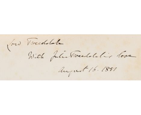
Birds.- Hay (Arthur, 9th Marquis of Tweeddale) The Ornithological Works ... reprinted from the Originals by the Desire of his Widow, first edition, presentation inscription by Julia Tweeddale to half-title, portrait frontispiece, hand-coloured map and 11 hand-coloured plates, occasional faint spotting, bookplate, contemporary half-morocco, a little rubbed, 4to, [Zimmer p.293; Anker 513; Wood p.605], 1881.⁂ Provenance: Ink inscription signed Julia Tweeddale, and dated 1881, to half-title. Bookplate of William Montagu Hay, the 10th Marquess. This copy contains the full complement of plates called for in the 'Philippine Archipelago'. Copies are also recorded with no colour plates (Wood) or 22 (Anker and Nissen).

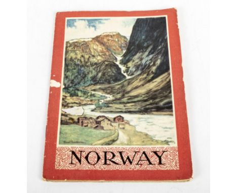
Hunting.- Chapman (Abel) On Safari: Big-Game Hunting in British East Africa, frontispiece, original pictorial cloth, a little rubbed, [Hosken p.45], 1908; Savage Sudan, frontispiece map, original pictorial cloth, rubbed, [Czech p.35], 1921; Wild Norway, frontispiece, previous owner's signatures, publisher's advertisements at end, original cloth, 1897, first editions, plates and illustrations, occasional spotting, slight bumping to corners and extremities; and 11 others by the same, most first editions, 8vo (14)

Tweedie (Major-General W.) The Arabian Horse, His Country and People, first edition, presentation copy signed by the author on front free endpaper, plates, some colour, illustrations, folding map in pocket at end, pp.257/258 and 263/264 misbound, handsomely bound in green morocco, gilt, by the Chelsea Bindery, with horse's head vignette to upper cover and palm trees to spine, g.e., 4to, Edinburgh & London, 1894.⁂ Inscribed by the author to Sir Alfred Lyall in the year of publication; also with Lyall's ownership inscription and tipped-in printed leaf of verse by him entitled 'A Hard Bargain' about the sale of an Arab horse.
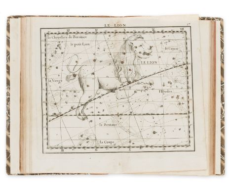
Flamsteed (John) Atlas Celeste de Flamsteed, approuve par l'Academie Royale des Sciences, second edition, edited by J. Fortin, 30 double-page engraved celestial maps, 40pp. star catalogue at end, additional double-page manuscript celestial map bound in, minor spotting and soiling, ink name of George Sloggett on title, modern morocco-backed boards, 4to, Paris, F.G. Deschamps, chez l'Auteur, 1776.

Chalmers (James) The Channel Railway, connecting England & France, first edition, lithographed title, folding map and large folding plate, modern half dark maroon morocco, g.e., 1861; another edition, second edition, large folding plate (torn but no loss), newspaper cuttings on channel tunnel schemes loosely inserted, original cloth, slightly rubbed and faded, 1867.⁂ Serious proposals for a fixed cross-Channel communication were first broached at the end of the 18th century but were deferred because of the Napoleonic wars. Several different proposals were made throughout the remainder of the 19th century. This crackpot scheme proposed submerging a tube and anchoring it with baskets of rocks etc. Chalmers claimed the project would cost £12,000,000 but would return £1,215,000 per annum thereafter. An enormous mid-channel lighthouse/ventilation shaft was central to the proposition. In the second edition, reissued seven years after the first, Chalmers tries to bolster his credentials with other successful but unrewarded engineering exploits, and the encouragement from R. Cobden. This time he proposes a twin-tubed tunnel.
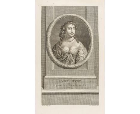
Jacobitism.- The Tryals of William Ireland, Thomas Pickering, and John Grove, for Conspiring to Murder the King, imprimatur leaf corner torn with slight loss, last f. torn and repaired, browned, disbound, Alistair Cooke's copy with his bookplate on pastedown of modern portfolio, [Wing T2268], Robert Pawlet, 1678 § Henderson (Andrew) The History of the Rebellion, MDCCXLV and MDCCXLVI, The Fifth Edition, browned, ink signature of J. Hyde at head of title, new endpapers, contemporary calf, slightly rubbed, corners worn, rebacked retaining the original label, for A. Millar, W. Owen, W. Reeve, and J. Swan, 1753 § Johnstone (James, Chevalier De) Memoirs of the Rebellion in 1745 and 1746, first edition, 3 engraved portraits and a map, title slightly offset, some foxing, modern bookplate, contemporary calf, gilt borders, slightly rubbed, rebacked in modern calf, 1820; and 18 others, Jacobitism, including an engraved portrait of Anne Hyde, v.s., v.d. (22).
-
108737 item(s)/page