We found 109182 price guide item(s) matching your search
There are 109182 lots that match your search criteria. Subscribe now to get instant access to the full price guide service.
Click here to subscribe- List
- Grid
-
109182 item(s)/page


![Anonymous [William Smith] 17th-century map of Staffordshire, hand-coloured copper engraving on laid/chain-lined paper, scarce](https://cdn.globalauctionplatform.com/053356bd-6440-4909-9a87-a95b00a497c4/cc9112ce-e70b-429c-8cec-ef1d2dc21270/468x382.jpg)


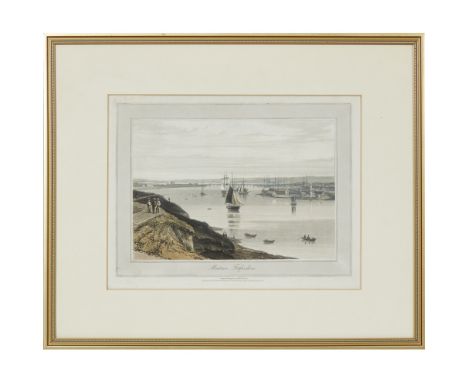
Lot 4253
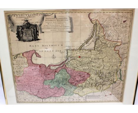
Speed, John (1552-1629). 17th-century map of Poland, hand-coloured copper engraving on laid/chain-lined paper bearing manufacturer's watermark, featuring inset city views and figures displaying regional fashions/costumes, published by Bassett & Chiswell, English text to verso. Framed & glazed to recto and verso (both sides visible). 41cm x 52cm
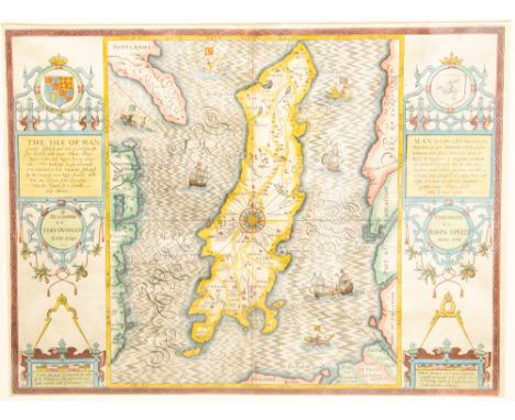
Lot 4255
Speed, John (1552-1629). 17th-century map of the Low Countries ('Ye XVII Provinces of Low Germanie'), showing Belgium and the Netherlands, featuring ships and sea monsters with inset city views and figures in regional costume, hand-coloured copper engraving on laid/chain-lined paper bearing manufacturer's watermark (Prince of Wales's Feathers), published by Bassett & Chiswell, English text to verso, weak impression possibly cleaned with repaired wear around fold-line. Framed & glazed to recto and verso (both sides visible). 42cm x 54cm
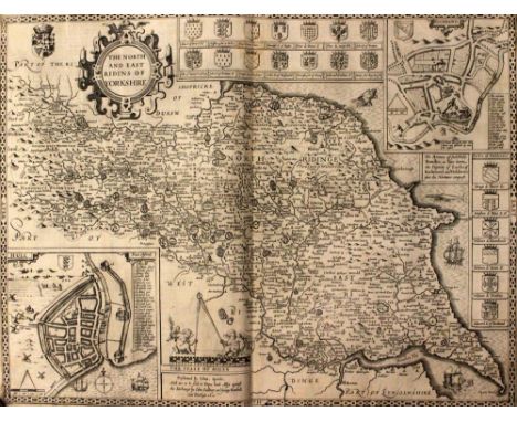
Lot 4255A
Speed, John (1552-1629). 17th-century map of The North & East Riding of Yorkshire, copper engraving on laid/chain-lined paper bearing manufacturer's watermark, featuring heraldic shields, inset views of Richmond and Hull, ships and sea monsters. Published by Sudbury & Humble, English text to verso. Some contemporary additions/annotation. Uncoloured/unmounted/unframed. Approx. 42cm x 55cm
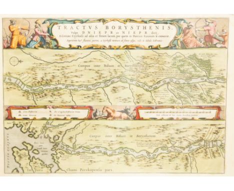
Lot 4256
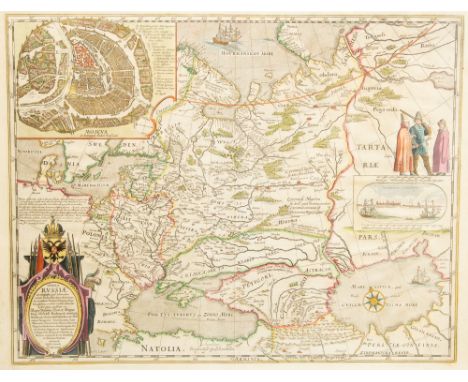
Blaeu, Joan (1596-1673). Scarce 17th-century map showing the Dnieper river flowing through Russia and Ukraine to the Black Sea, featuring figures in battle at either side of title/cartouche, hand-coloured copper engraving on laid/chain-lined paper bearing manufacturer's watermark of a standing figure, French text to verso, clean & bright with wide margins but area of dampstaining at upper-right (almost entirely confined to the wide margin). Framed & glazed to recto and verso. 55cm x 65cm
Lot 4259
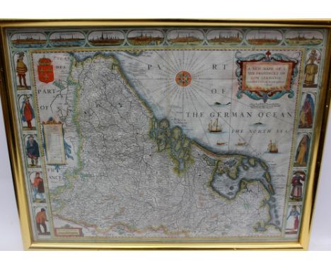
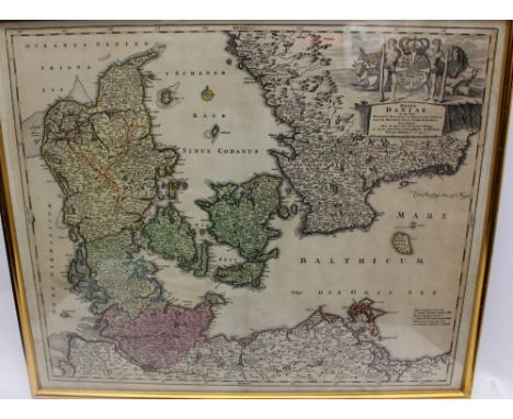
Hondius, Henricus (1597-1651). 17th-century map of the Duchy of Holstein, featuring inset views and sailing ships, hand-coloured copper-engraving on laid/chain-lined paper, English text to verso describing Denmark. Framed & glazed to recto and verso. 34cm x 53cm. Together with Johann Baptist Homann (1664-1724), map of the Kingdom of Denmark, hand-coloured engraving on laid paper, no date, 51cm x 61cm (2)
Lot 4268
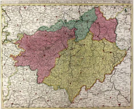
Delisle, Guillaume (1675-1726). Early 18th-century map of Scandinavia showing Denmark, Norway and Sweden, hand-coloured copper engraving on laid/chain-lined paper, unmounted/unframed. 57cm x 68cm. Together with a map of Saxony/Germany and a map of Pomerania/Brandenburg by Gerard Valck (1652-1726). 52cm x 63cm (3)


![NO RESERVE Frutaz Amato Pietro. Le carte del Lazio. [Roma: Arti Grafiche Luigi Salomone; A. Staderini S.p.A, 1972]. Un'opera](https://cdn.globalauctionplatform.com/72d5ee8a-8267-4936-b51f-a96500fc48d6/573deb2e-166e-4a24-8673-b9b71136d348/468x382.jpg)
Lot 67
NO RESERVE Frutaz Amato Pietro. Le carte del Lazio. [Roma: Arti Grafiche Luigi Salomone; A. Staderini S.p.A, 1972]. Un'opera in 3 volumi (mm 362x265). I. Pagine L, 263, [1]. II. Tavole numerate 1-232, alcune ripiegate e a colori. III. Tavole numerate 233-484, alcune ripiegate e a colori. Esemplare in ottimo stato di condizione. Legature editoriali uniformi, in tela verde. Al piatto anteriore di ogni volume titolo e medaglione con riproduzione di una carta del Lazio, impressi in oro. Dorso liscio con titolo e numero del volume in oro, su doppio tassello rosso. Qualche alone ai piatti.Altra importante opera cartografica curata dall'archeologo Amato Pietro Frutaz (1907-1980), già autore del monumentale Le piante di Roma (vedi lotto precedente). Altrettanto autorevole il repertorio dedicato alle piante del Lazio, che accuratamente presenta una amplissima selezione di materiale cartografico, in un arco temporale che va dal III secolo DC agli anni 1970-1972. Anche questo repertorio fu pubblicato su iniziativa dell'Istituto di Studi Romani, in una tiratura di 1.000 esemplari.One work in 3 volumes (362x265 mm). I. L, 263, [1] pages. II. Plates numbered 1-232, some of which are folded, or coloured. III. Plates numbered 233-484, some of which are folded, or coloured. Copy in excellent condition. Uniform publisher's bindings, green cloth. On the upper cover of each volume gilt title and medallion depicting a map of Lazio region, embossed in gilt. Smooth spines, title and volume numbering in gilt on double lettering-piece. Covers spotted in places.Highly remarkable and authoritative reference book on the cartography of Lazio region, edited by the archaeologist Amato Pietro Frutaz (1907-1980), the author of the monumental Le piante di Roma (see previous lot). The three-volume publication - printed in a limited edition of 1,000 copies - collects maps dating from the 3rdy centurAD to the years 1970-1972, and was issued on behalf of the Istituto di Studi Romani.


Lot 368
A London Underground map,designed by Harry Beck, late 1930s, showing the planned extensions of the Central Line to Ongar and Denham, which were never completed, and the Northern Line to Alexandra Palace, High Barnet and Bushey Heath, printed by Waterlow & Sons Ltd., London, 82 x 62cm in an oak frame


![[Naval] Programmes for the Review of the Fleet by His Majesty The King at Spithead, 1935, 1937 and 1953 each with folding map](https://cdn.globalauctionplatform.com/c0008bde-a610-4fb3-9458-a96c00dfaf0e/34b4bfde-db61-49fc-ce95-d4b85b3f6eaf/468x382.jpg)
Lot 180
[Naval] Programmes for the Review of the Fleet by His Majesty The King at Spithead, 1935, 1937 and 1953 each with folding map, together with admittance tickets to SS Sandown, SS Queen of Thanet and the SS Southsea with copy of The Romance of London River by A.G. Thompson illustrated by Helen McKie 1935 and an album of photographs which appear to be taken at the fleet review


Lot 341
TWELVE ENGRAVINGS AND MAPScomprising: Daniell, W. Montrose - Forfarshire; Small map of Forfarshire; Small steel-engraving of Montrose; Hogg, Alexander: View of Montrose in Angus-shire; Mary Stewart Queen, engraved by R. Dunkarton; Chromolithograph of an unidentified house; Abelard & Eloise, sold by Carrington Bowles; Hogarth, W.: The Enraged Musician, 1741; Engravings of houses: Duninald, Southesk, Usan, Rossie Castle (12)

Lot 488
ABERDEEN AND MONTROSE, FIVE MAPSINCLUDING ADAIR, JOHNThe Towne & Water of Montrose, 1693, hand-coloured in outline, 47 x 32cm; [Idem] The Towne and Water of Montross [sic.], 1697, hand-coloured in outline, 31 x 51cm; Collins, Grenville. Citty of Aberdeene [sic.]…, facsimile of the 1774 chart, hand-coloured, 45 x 57cm; Gardener. Plan of Montrose, 44 x 30cm; An early strip road map of the route from Edinburgh to Stonehaven, 16 x 8cm; all framed and glazed (5)


-
109182 item(s)/page