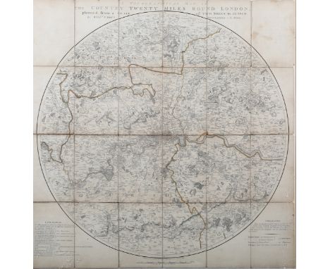
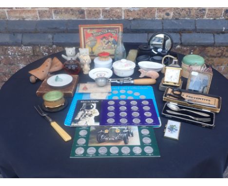
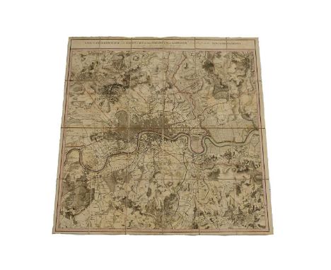
William Faden (publisher) - 'A Topographical Map of the Country Twenty Miles Round London, planned from a scale of two Miles to an Inch', engraving in 24 sections backed onto linen, published by Faden 1790, 62cm x 61cm, within a Perspex frame.Buyer’s Premium 29.4% (including VAT @ 20%) of the hammer price. Lots purchased online via the-saleroom.com will attract an additional premium of 6% (including VAT @ 20%) of the hammer price.
We found 109182 price guide item(s) matching your search
There are 109182 lots that match your search criteria. Subscribe now to get instant access to the full price guide service.
Click here to subscribe- List
- Grid
-
109182 item(s)/page
A 21st century 'King Henry's Map of the British Isles', The Folio Society, 2009, limited edition (2,750), facsimile map, reproduced from Cotton MS Augustus in the British Library and printed on Neobond (a high quality simulation vellum), silk ribbon tie, housed in original velvet lined decorative blue cloth gilt map box, printed paper label inside lid, metal clasp. Measures 63 x 46cm.
Stanford's New Two Inch Map of London and its Environs - Main Road and Tramline Edition, published by Edward Stanford 1924, showing all the main Tram routes from Heston to Barking, and Tottenham to Croydon, the map dissected and laid down on linen, with some name stamps from a previous owner J.H.C Bates, with Stanford's Library Maps label to the inside, 73cm x 115cm
A Royal Engineers 461st Field Company Military and Bar medal group of three, awarded to Sergeant John Henry (476433), Henry was awarded the Military medal for rescuing men who were wounded, gassed and buried within a shelter while under heavy fire, sold with a large black and white photograph of the 3/1st West Riding Field Coy, Royal Engineers 1916, and Daily Mail map
A New Topographical Map of the Country in the Vicinity of London, describing all the New Improvements, drawn on a scale of two inches to a statute mile, published by William Faden, dated 1815, covering from East Acton to Barking and Upper Edmonton to Beckenham, hand coloured, dissected and laid down on linen, sold by C. Smith (Mapseller No.172, Strand)with retailer's cardboard sleeve, with handwritten ink annotation, 84cm x 83cm
La Touche (J.D.D.). J. D. D. La Touche - A Handbook of the Birds of Eastern China (Chihli, Shantung, Kiangsu, Anhwei, Kiangsi, Chekiang, Fohkien, and Kwangtung Provinces), 2 volumes, 1st edition, Taylor & Francis, 1925-34, black & white plates, two folding colour maps, original printed wrappers from original parts retained at rear of each volume, period cloth binding, together with Then-Hwang Shaw - The Birds of Hopei Province', Peking, 1936, with folding colour map, good modern rebinding, together with various other Chinese bird books. (7). C98.
'TYPUS ORBIS TERRARUM': A CONTINENTAL POTTERY RECTANGULAR TILE PANEL (20)Probably 19th century After an original map by the Dutch cartographer, Abraham Ortelius ( 1527-1598), comprising twenty square tiles depicting a map of the world, the corners with panels enclosing texts from Cicero and Seneca, 82cm by 102cmSome repair, losses, cracks and chips
`TYPUS ORBIS TERRARUM': A CONTINENTAL POTTERY RECTANGULAR TILE PANEL (20)Probably 19th century After an original map of the world by the Dutch cartographer, Henricus Hondius ( 1597-1651), comprising twenty square tiles and painted with double sphere map, the corners with portraits of Julius Caesar and the cartographers Claudius Ptolmy, Gerard Mercator and Jodocus Hondius, 82cm by 102cmOne tile has been broken in half and repaired. Some overall losses, cracks and chips
English History/Topography. Walcott, Mackenzie E. C. - The East Coast of England, &c. London: 1861; White, William - History, Gazetteer, and Directory, of Norfolk, &c. 1836. Map not present as usual; Grainge, W. - The History and Topography of Harrogate, &c. London: 1871. With folding map and 2 plates. Each in original/contemporary binding. (3)
Folding Maps. Philip's Map of England & Wales Shewing all the Lines of Railway, Canals, &c. London: George Philip and Son. No date, circa 1860. In 30 folding sections, linen backed, coloured. Loose in blind-stamped cloth-covered boards. With; Cruchley's Railway & Telegraphic Map of Yorkshire. London: G. F. Cruchley. (2)
Local History. [West, Thomas] - The Antiquities of Furness; &c. London: Printed for the Author, 1774. Complete with the Abbey Plan (linen backed); County Map (linen backed); and the East Prospect plate (repair on reverse). Rebound in a maroon half morocco, over cloth boards. New end papers and blanks. With; Janet Whitney's Elizabeth Fry biography (1938 reprint). (2)
Local History. Collingwood, W. G. - The Lake Counties. London: Frederick Warne, 1932. Limited edition, no.149/350. Signed by Collingwood and Reginald Smith. Illustrated with plates, line drawings and folding map. Original green cloth. Former owner inscription erased with correction fluid. (1)
A group of three maps, comprising a 17th century map of Leicester, double sided, 43.5 by 55cm, framed and glazed, 49.5 by 61cm; a map of 'Darbyshire', by Robert Morden, 36 by 42cm, framed and glazed, 40 by 46.5cm, together with a map of Stafford, 49 by 44cm, framed and glazed, 58.5 by 52cm. (3)
-
109182 item(s)/page