We found 108737 price guide item(s) matching your search
There are 108737 lots that match your search criteria. Subscribe now to get instant access to the full price guide service.
Click here to subscribe- List
- Grid
-
108737 item(s)/page


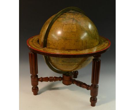
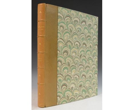
Lot 3302
A 19th century table globe, Malby's Terrestrial Globe, Compiled from the Latest and Most Authentic Sources Including all the Recent Geographical Discoveries, Manufactured and Published Under the Superintendence of the Society for the Diffusion of Useful Knowledge by Malby & Sons, Globe & Map Sellers to the Admiralty, Published at the Globe Manufactory, 37, Parker Streey, Little Queen Street, Holborn, London, brass meridian ring and hour circle, twelve gores and two polar caps, the mahogany stand with turned and fluted legs and stretchers, 48cm high


Lot 112
Pitt (William) A Topographical History of Staffordshire, 1 vol illus 1817 with folding map; Harwood (T) A Survey of Staffordshire containing the antiquities of that County 1820; Nightingale (Rev) A Topographical & Historical description of the County of Stafford, circa 1808 with folding map; and Garner (R) The Natural History of the County of Stafford 1844 (4)


Lot 3884A
Militaria, World War Two, RAF, Bomber Command: cloth backed colour printed aviation OS maps: 38 x 26in Straights of Dover 3rd edition, 1:500,000: sheet 8 also three copies 4th edn; two 1: 253440 N Wales & Manchester area war revision sheet 4; 30 x 23.5in 1: 250,000 Map of Essen (Germany) area 1936 rev. 1942 sheet M.32/1; also 8 copies of Frankfurt sheet 1:500,000 1940 edition, [15]

Lot 4011
Charles Smith (fl. 1804), Smith's New Map of England and Wales with Part of Scotland, Including the Turnpike, and principal Cross Roads, the Course of the Rivers & Navigable Canals; The Cities, Market Towns, and most considerable Villages; pointing out the distance from London to every principal Town; likewise the distance from one Market Town to another, Drawn from the latest Authorities, London: Printed for C. Smith, Mapseller, 172, (corner of Surrey Street), Strand, 1821, 42 folds, engraving with contemporary hand-colouring, laid on linen, 117cm x 95.5cm, contemporary marbled card sleeve applied with printed publisher's label, [1]
![Francis Lamb (fl. 1667 - 1701), after Captain Greenville Collins (1643-1694), two-page map, Dartmouth [Devon], [Dedicated] To](https://cdn.globalauctionplatform.com/b5d0520c-3f9d-4619-b761-abe600c55abf/1d4b6d19-d026-4baf-973d-ac0500cb33cc/468x382.jpg)
Lot 4012
Francis Lamb (fl. 1667 - 1701), after Captain Greenville Collins (1643-1694), two-page map, Dartmouth [Devon], [Dedicated] To the Right Honourable George Lord Dartmouth, Mr Generall (sic) of his Majesty's Ordnance &c [...], allegorical and armorial dedication cartouche, numbered 15 within the plate, [London: early-mid 18th century], copperplate engraving with contemporary hand-colouring, 46cm x 57cm

Lot 4013
George Vertue FSA (1684-1756), after Ralph (Radulph) Algus (c. 1540-1621), Civitas Londinum Ano Dni MDLX, Vertue Soc, Antiq. Lond. excudit 1737, [London: Published for the Society of Antiquaries], 33-fold panoramic map of Elizabethan London, upper-left and upper-right margins with the arms of Elizabeth I and the City of London respectively, the lower-margins with three text boxes, engraving later conserved and relaid on linen, 194cm x 71.5cm, contemporary marbled sleeve case applied with a ink MS collector's label inscribed: 1 Plan of London (Circa) 1560, T.II.9, Re-Engraved by George Vertue 1737/(The earliest engraved map or plan of London) by Ralph Aggas (sic))/Original in Sloane Collection, British Museum, later annotated and underlined in pencil: Very valuable, later 19th century green crowned library stamp, [1]
![Ja. Clerk (18th century), after Captain Greenville Collins (1643-1694), two-page map, Fowey & Mounts-Bay [Cornwall] Is mo](https://cdn.globalauctionplatform.com/b5d0520c-3f9d-4619-b761-abe600c55abf/15b065f7-4b64-4efe-b4a5-ac0500cb3486/468x382.jpg)
Lot 4014
Ja. Clerk (18th century), after Captain Greenville Collins (1643-1694), two-page map, Fowey & Mounts-Bay [Cornwall] Is most Humbly Presented & Dedicated To the Right Reverend Father in God Jonathan Lord Bishop of Bristol [...], allegorical and armorial dedication cartouche, numbered 17 within the plate, [London: 18th century], copperplate engraving with contemporary hand-colouring, 44.5cm x 56cm

Lot 4015
John Andrews (1736-1809), A New Physical, Historical, & Political Map, of England and Wales, From actual Surveys, & Astronomical Observations of the Royal Society, Exhibiting the natural state of its Surface, by describing the great Range of Mountains, Hills, and High Lands, which separate the Heads of the Rivers, & point out their Course from its Spring to the Ocean; All the Noblemens (sic) and Gentlemens (sic) Seats, Cities, Boroughs, Market-Towns, Rectories, Villages, Chapels, Vallies, Rivers, Canals, Bathing Places, Parks, Forests, Marshes, Turnpike, & Principal Cross Roads, with the distances from Town to Town, according to the Mile Stones, & other exact Mensurations, [London]: John Andrews, Geographer and Map-seller, No. 211, facing Air Street, Piccadilly, 1786, 36 folds, engraving picked-out in contemporary hand-colouring, laid on linen, 162cm x 134cm, contemporary marbled sleeve, publisher's printed label to upper-cover, [1]

Lot 4016
John Cary (c. 1754 - 1835), Cary's Reduction of his Large Map of England and Wales, with Part of Scotland; Comprehending the whole of the Turnpike Roads, With the Great Rivers and the Course of the different Navigable Canals: Also The Market and Borough Towns, and principal places adjoining the Road, to which is added, The actual distance from one Market Town to another; with The exact measurement prefixed to each from the Metropolis, Published by Order of And Dedicated with Permission to The Right Honourable the Post Master General [...], London: Published by J. Cary Engraver and Mapseller [...], 1834, 20 folds, hand-coloured engraving laid on linen, 77cm x 63.5cm, contemporary mottled card sleeve case applied with printer's paper label, [1]

Lot 4017
John Cary (c. 1754 - 1835), Cary's Reduction of his Large Map of England and Wales, with Part of Scotland; Comprehending the whole of the Turnpike Roads, With the Great Rivers and the Course of the different Navigable Canals: The Market and Borough Towns, and principal places adjoining the Road, to which is added, The actual distance from one Market to another; with The exact admeasurement prefixed to each from the Metropolis, London: Published by J. Cary [...], 1830, 20 folds, engraving with contemporary hand-coloured delineation, 78.5cm x 46.5cm, contemporary card sleeve with printed label as issued, [1]

Lot 4018
John Speed (1552-1629), by and after, a two-page map, The Counti (sic) of Warwick the Shire Towne (sic) and Citie (sic) of Co:ventre (sic) described, [London]: [...] Sold by Thomas Bassett in Fleetstreet (sic), and Richard Chiswell in St. Pauls Churchyard, dated 1630 within the platemark, named-view street plans of Warwick and Conventry, the lower-right margin with the coats of arms of the Earls of Warwick of all four creations, etching and engraving with contemporaneous hand-colouring, vernacular English text to verso, 40cm x 54cm

Lot 4020
John Speed (1552-1629), by and after, two-page map, The Countie (sic) of Nottingham described, The Shire Townes (sic) Situation and the Earls There of observed, [London]: [...] sold in Popes head Alley by John Sudbury and Georg. Humble, dated 1610 but later 17th/early 18th century, English vernacular text to verso, copperplate engraving with contemporary hand-colouring, lightly trimmed, 40cm x 50cm

Lot 4021
Local Interest - Christopher Greenwood (1786-1855) and John Greenwood (fl.1821-1840), A Map of the County of Derby, From an Actual Survey made in The Years 1824 & 1825, [...], Dedicated to the Nobility, Clergy & Gentry of the County, By the Proprietors, London: Published Dec:r 21st 1825, lower-left margin with a named-view vignette of Chatsworth House by William Woolnoth (1780-1837) after R. Creighton (fl. 1820), the lower-right margin with a pictorial key, 48-folds, monochrome engraving laid on linen, 157cm x 121.5cm, contemporary gilt-lettered red calf over marbled sleeve case, applied with a ink MS label numbered: No. 30, [1]
![Wales - Thomas Dix, Surveyor, [of] North Walsham (fl. 1820), A New Map of North Wales divided into its Six Counties or Shires](https://cdn.globalauctionplatform.com/b5d0520c-3f9d-4619-b761-abe600c55abf/07f1c8e0-23dd-4f04-9ae4-ac0200e75eca/468x382.jpg)
Lot 4025
Wales - Thomas Dix, Surveyor, [of] North Walsham (fl. 1820), A New Map of North Wales divided into its Six Counties or Shires, London: William Darton, 58 Holborn Hill, June 13 1820, lower-left named-view monochrome landscape vignette of Snowdon, 20 folds, hand-coloured copperplate engraving laid on canvas, 58.5cm x 72cm, verso of map with printed labels, the contemporary mottled card sleeve conforming, (1); Charles Smith (fl. 1804), A New Map of the County of Monmouth, Divided into Hundreds, London: Printed for C. Smith, No. 172 Strand, January 6th 1804, 12 folds, hand-coloured engraving laid on linen, 52.5cm x 48cm, contemporary marbled wallet sleeve applied with printer's paper labels, (1), [2]

Lot 4026
A large collection of Admiralty charts, flat folded charts 41 x 28in (104 x 71cm) on laid paper, covering British Isles, Norway, Canadian east coast, Iceland, Greenland, arctic islands, scales varying from 1:25,000 to 1:4.570,800, Admiralty issues 1954-1964, used by Fred Olsen ships and all stamped Cancelled on reverse 48 in all, also set of four rolled-up Admiralty fishing grounds charts: Bear Island, East of Kanin, North Sea & Scotland to Norway, similar dates; US Air Force air navigation charts 1961 edition: London to Moscow & Davis Strait to Sheltland Is. 54 x 36in (1377 x 91.5cm); also two Geological maps of British Isles 1961, also Shrewsbury sheet 1 in:1 mile OS geological map, two educational charts: Grimsby before enclosure 44 x 24in (112 x 61cm) 1962 by Rex Russell, Corporation of London governance 1950s, 30 x 40in (76 x102cm) (qty)

![John Speed (1552-1629), by and after, a two-page map, Surrey, Described and Divided into Hundreds, [London]: John Sudbury and](https://cdn.globalauctionplatform.com/b5d0520c-3f9d-4619-b761-abe600c55abf/32498aa8-119f-4acd-8561-ac0200e75f67/468x382.jpg)
Lot 4028
John Speed (1552-1629), by and after, a two-page map, Surrey, Described and Divided into Hundreds, [London]: John Sudbury and George Humble, [n.d., c. 1627], the upper-left and upper-right margins with named-views of the Tudor royal palaces of Richmond and Nonsuch, English text to verso, monochrome engraving, 40.5cm x 52.5cm, Hogarth-type frame, [1]

Lot 4029
John Speed (1552-1629), by and after, two-page map, Stafford Countie (sic) and Towne (sic) with the ancient Citie (sic) Lichfeild (sic, Lichfield) described, [London]: [...] by Tho: Bassett in Fleetstreet (sic), and Ric Chiswell in St Pauls Churchyard, English vernacular text to verso, late 17th/18th century copperplate engraving with contemporanoues hand-colouring, 41.5cm x 53.5cm
![Richard Blome (1635-1705), by and after, map, [...] Cumberland (Cumbria) [...], lower-right margin with the coats of arms of](https://cdn.globalauctionplatform.com/b5d0520c-3f9d-4619-b761-abe600c55abf/64f4b6cd-d3ba-4c19-8ad4-ac0200e760a9/468x382.jpg)
Lot 4030
Richard Blome (1635-1705), by and after, map, [...] Cumberland (Cumbria) [...], lower-right margin with the coats of arms of Charles Howard, 1st Earl of Carlisle (1629-1685), London: Printed for Richard Blome, 1672, engraving with contemporaneous hand-colouring in gouache and watercolour, 33.5cm x 27cm
![William Hole (d. 1624), after Christopher Saxton (c. 1540 - c. 1610), Universi: Derbienfis Comitatus [...] (sic), two-page ma](https://cdn.globalauctionplatform.com/b5d0520c-3f9d-4619-b761-abe600c55abf/da653a0c-9f2c-4c53-870a-ac02005ea740/468x382.jpg)


Lot 4133
Local Interest - Derby - a collection of deeds relating to the sale and sub-division of the Littleover Hill estate, now Whitaker Road, 1845 onwards, vellum deeds,printed map showing lots into which the estate was divided, MS receipts along with subsequent deeds to Oakdene, in cardboard folder (qty)
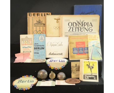
Lot 4149
Nazi Germany/Third Reich - 1936 Berlin Olympics, an archive-collection of 50 souvenir pieces and ephemera, including a Junghans pocket watch, the brass circular dial centred by the Reichsadler, the verso in relief with the Brandenburg Gate above the five Olympic rings, (1); Reichskulturkammer metal watch or medal case, dated 20 April 1936, (1); another, similar, Reichsadler, Olympic rings and Berlin 1936 only, (1); Tickets: Football Semi-Final, &, Handball Final, each torn for use, (2); official programmes for rowing, ice skating, athletics, sailing, gymnastics, handball and diving, (7); Deutsches Opernhaus Berlin seasonal programme, unsurprisingly Wagner's operas with a cast sheet for Lohengrin loosely inserted, (2); the official Olympic Games badge, in tones of blue, black, red, yellow and green enamel, (1); Newspapers, 3 copies of the Olympia Zeitung: No. 17, 6th August, No. 21, 10th August, & No. 28, 17th August, (3); Winter Olympics, Die Olympischen Spiele 1936, In Berlin und Garmisch-Partenkirchen, volume I only, b/w illustrations, contemporary pictorial blue cloth, 4to, (1); a leather purse, Olympiade Berlin 1936, (1); Coin, 1936, 5 Reichsmark, (1); Banknote, 20 Reichsmark, (1); Travel/Tram tickets, various, (4); two Art Deco design circular beadwork samplers, Berlin, variously coloured Bakelite-type beads, (2); Willkommen in Berlin..., pocket guide, (1); official Summer Olympics visitors' programme, (1); Deutsche Reichspost guide, multiple languages, (1); Reich Committee tourist sheet, (1); Olympia-Gale, Dresden: [1936], (1); songs/hymnal sheet, (1); official city map, issued for the Olympics; further official programmes and other ephemera, [50]
Lot 4155
Ireland, Irish Ascendency - Royalty, the Court and the British Army - a large Victorian matrimonial scrapbook, compiled and illustrated by General Sir Alexander Montgomery Moore KCB (1833-1919) and his wife Lady Jane (née Colborne, d. 1919), of Garvey House, County Tyrone, various tipped-in ephemera, prints and original compositions, including a Georgian verse satire in ink MS on paper 'of about 1780' illustrating a lawsuit between the Moores and Ld Castle***; Anglo-Irish caricature, "Justice to Ireland", General Sir James Vaughan Jackson (1790-1871), in profile in civilian dress, while Commander-in-Chief in the Cape of Good Hope from 1854-59, mixed media on paper; an Anglo-Indian printed dance card from Simla, 20th August 1869, two further contemporary ball invitations to the Montgomery Moores; 2 sepia photographs of natives' executions; a handful of topographical watercolours of South-East Asia, principally architectural; some other military and topographical photographs; further ephemera illustrative of their life within the establishment of the British Raj; an 1856 MS bill for fare from the Greek island of Syra (Syros/Siros); 2 landscapes of Smyrna from the deck of *** and dated January 27th 1855, &, The French Camp at the Battle Field of Inkerman [Crimean War], February 10th 1855; a blue-printed and ink-annotated dinner menu from H.M.S. Serapis; Austria-Hungary, a bill of from the Schönbrunn Palace, Vienna, on the 100th anniversary of the institution of the Order of Maria Theresa, a corresponding Ordre de Bataille for a military ceremony commemorating the same occasion, 18th June 1857; Royalty, a VR orange admittance ticket from the Lord Chamberlain's office for the Montgomery Moores to attend the State Apartments, St. James's Palace, for the marriage of the Princess Royal, January 25th, 1858, pasted above the Order of Procession; Marlborough House garden party invite issued on behalf of the Prince & Princess of Wales (later Edward VII and Queen Alexandra); various Golden Jubilee invitations, including the Westminster Abbey Thanksgiving Service, Buckingham Place State Concert, Summer Garden Party; further invitations, menu cards, etc., from across the Continent; A Moorish Physician's Charm against Sickness frrom Tangiers, March 1859, tipped-in parchment; French Society visiting cards; Royal Hussars manoeuvres map, pen and ink with watercolour; further regimental ephemera; a few pen and ink, pencil or wash studies of soldiers and military manoeuvres en plein air; two sepia photographs of the French military at the Sahara Desert; country house weekend parties, a handful of photographs - guests, staff and houses; telegram; notices of the Parnell Letters, the death of Alfred, Lord Tennyson; R.H. Essex, watercolour of a Medieval head from a mural at Eton College chapel; further Etoniana, including the Boating Calendar: 1849 & the newspaper (presumably the Times) viz. the Fourth of June in 1889; a page devoted to the death of Prince Albert and Court mourning, illustrated by a print and newspaper notices; an account of the 1869 Delhi Durbar; Emperor Maximilian of Mexico Trial and Execution; Gun Experiments at Dover, a newspaper clipping mentioning General Montgomery Moore; 4 newspaper accounts of the 2nd Encampment of the Dublin Division under Lord Seaton (Lady Jane's father) at Woodlands, September 16th 1858; further newspaper clippings, one illustrating The Uses of Ammonia, another The Czar's Last Moments (presumably Tsar Nicholas I, d. 1855), 3 letters to the Times on Lord Nelson's death; two caricatures of the British Army wearing shell jackets accompanied by an account of a House of Commons debate on the subject, 25th May 1849; A Fenian Proclamation at Drogheda, some Irish ballads and poems from printed periodicals, Irish Election Committees: Drogheda Borough and further notices of Irish elections and politcs; a page devoted to prints of Napoleon and French soldiers of the early Republic; music poster, A Grand Amateur Concert, Dublin, 22nd February 1884; a page annotated and illustrated with stipple engraved portraits of the then British Royal Family, including Queen 'Snuffy Charlotte'; early 19th century and later prints, various subjects -including caricatures - and mixed media engravings, some French, a handful loosely-inserted; Punch cartoons; an early 19th century military map of Antwerp; English antiquarian and topographical watercolours; a few 17th century etchings; etc., further scraps and memories of the Victorian age, mounted on colour leaves, contemporary half-calf over marbled boards (rubbed), crown folio (41cm x 31cm, [1]
![[Gough (Richard)], An Essay On the Rise and Progress of Geography in Great-Britain and Ireland, Illustrated with Specimens of](https://cdn.globalauctionplatform.com/b5d0520c-3f9d-4619-b761-abe600c55abf/2000d342-0ee5-4acf-bbda-ac0200e768e5/468x382.jpg)
Lot 4170
[Gough (Richard)], An Essay On the Rise and Progress of Geography in Great-Britain and Ireland, Illustrated with Specimens of our Oldest Maps, London: Printed by J. Nichols, Printer to the Society of Antiquaries, 1780, pp: vii, 90 (mispaginated 1-78, 81-92), xii, illustrated with 8 fold-out plates of maps (Plate VIII in 3 parts) and one additional extra-illustrated plate after title-page, [bound with], Bannister (S.), A Brief Description of the Map of the Ancient World, Preserved in the Cathedral Church of Hereford, Hereford: Printed and Published by T. T. Davies, [...], 1849, 12pp, six-fold chromolithograph facsimile after B. Tucker, mid-19th century green quarter-calf over marbled boards, fragmentary gilt-lettered spine, the base with the crest of Rylands, 4to, [1]Provenance: Thomas Glazebrook Rylands (1818-1900), of Highfields, Thelwall, Cheshire, his Plain Armorial bookplate to recto pastedown; by descent to his son, John Paul Rylands, FSA (1846-1923), his Golden Age Armorial bookplate below the latter.
![Bibliography - Chubb (Thomas), The Printed Maps in the Atlases of Great Britain and Ireland: A Bibliography, 1579-1870 [...]](https://cdn.globalauctionplatform.com/b5d0520c-3f9d-4619-b761-abe600c55abf/21d10a28-313d-46e7-93a1-ac0200e76b54/468x382.jpg)
Lot 4175
Bibliography - Chubb (Thomas), The Printed Maps in the Atlases of Great Britain and Ireland: A Bibliography, 1579-1870 [...] And Biographical Notes on the Map Makers, Engravers and Publishers [...], with Numerous Reproductions of Title Pages, Etc., London: The Homeland Association, Ltd., 1927, contemporary green cloth as issued, 8vo, [1]
![Cartography - [Cary (John)], Cary's New Map of England and Wales with part of Scotland on which are carefully laid down all t](https://cdn.globalauctionplatform.com/b5d0520c-3f9d-4619-b761-abe600c55abf/18f0ec96-bee1-4e26-944a-ac000127a922/468x382.jpg)
Lot 4180
Cartography - [Cary (John)], Cary's New Map of England and Wales with part of Scotland on which are carefully laid down all the Direct and Principal Cross Roads, the Course of the Rivers and Navigable Canals [...], first edition, London: 1794, lacking title-page, 82 sheets of copperplate engravings with contemporary hand-colouring and/or delineation, [index]: 85pp, List of Subscribers: [3], 20th century brown morocco gilt over marbled boards, endpapers marbled en suite, 4to, [1]
![Cartography - [Cary (John)], Cary's Survey of the High Roads from London [...], On a Scale of one Inch to a Mile; Wherein Eve](https://cdn.globalauctionplatform.com/b5d0520c-3f9d-4619-b761-abe600c55abf/a86a1a9d-ea2a-46d0-b713-ac0200e76dce/468x382.jpg)
Lot 4181
Cartography - [Cary (John)], Cary's Survey of the High Roads from London [...], On a Scale of one Inch to a Mile; Wherein Every Gentleman's Seat, situate on, or seen from the Road, (however distant) are laid down, with the Name of the Possessor; to which is added The Number of Inns on each separate Route; Also, The different Turnpike Gates, shewing (sic) The Connection which one trust has with another, London: Printed for J. Cary [...], 1790, pp: [3], one engraved and hand-coloured full-page map: General Plan, another fold-out, 80 columnar strip maps over 40 pages and picked out with contemporary hand-colouring, rebacked contemporary mottled calf, 8vo, [1]
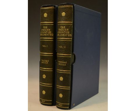
Lot 4185
Cartography - Bindings - Moule (Thomas), The English Counties Delineated; or, A Topographical Description of England, Illustrated by a Map of London, and a Complete Series of County Maps, two-volume set, London: George Virtue, 1837, pp: xxiv, 484; [i], 582, additional engraved title-pages, full-page and fold-out maps with contemporary hand-colouring, all as called for, 20th century blue morocco gilt, by Graham Bloodworth of Leicester, his ticket, the covers with an intersecting singular-fillet enclosing Tudor roses at angles, spines of six-compartments with raised bands, lettered in the second, third and fourth compartments, the remaining enclosing further Tudor roses, dated at the base, marbled endpapers, contemporary speckled red edges, slipcased en suite in blue buckram with fleece-lined interiors, 4to, [2]
Lot 4186
Cartography - Cary (John), Cary's New and Correct English Atlas: Being A New Set of County Maps from Actual Surveys, Exhibiting All the Direct and principal Cross Roads, Cities, Towns, and most considerable Villages, Parks, Rivers, Navigable Canals & c., Preceded by a General Map of South Britain, Shewing (sic) The Connexion (sic) of one Map with another, Also A General Description of each County, And Directions for the junction of the Roads from one County to Another, first edition, London: Printed for John Cary [...], 1787, pp: [x], 16, [1], 46 full-page copperplate engraved maps with contemporary hand-coloured delineation, each county/regional map with descriptive letterpress/letterpresses, 20th century beige morocco gilt over marbled boards, endpapers marbled en suite, 4to, [1]

Lot 4188
Cartography - Moll (Herman), Great Britain, London: 1717, an album of 12 two-page engraved maps delineated in contemporary hand-colouring, comprising: A Pocket Companion of ye Roads, of ye South Part of Great Britain, Called England and Wales [...]; A Pocket Companion of ye Roads of ye North Part of Great Britain Called Scotland [...]; An Actuall (sic) Survey of the Road from London to Bath [...]; An Actuall (sic) Survey of the North West Road from London to Holy Head &c. [...]; An Actuall (sic) Survey of ye Road from London to St. Davids [...]; An Actuall (sic) Survey of the Road From London to the Lands-End [...]; An Actuall (sic) Survey of the Rod from London to Aberistwith (sic, Aberystwyth) [...]; and a further 5 road maps, each map leaf 29.7cm x 33.5cm or 33.5cm x 29.7cm, and with chamfered or canted angles and laid within a conserving paper frame, 20th century blue morocco gilt over marbled boards, endpapers marbled en suite, small folio (30.5cm x 18cm), [1]
![Cartography - Prince Augustus Frederick, Duke of Sussex's Copy - Ogilby [(John)], Owen [(John)], & Bowen (Em[manuel]), Britan](https://cdn.globalauctionplatform.com/b5d0520c-3f9d-4619-b761-abe600c55abf/c29093e8-3811-4236-aa8f-ac0200e77158/468x382.jpg)
Lot 4190
Cartography - Prince Augustus Frederick, Duke of Sussex's Copy - Ogilby [(John)], Owen [(John)], & Bowen (Em[manuel]), Britannia Depicta, or Ogilby Improv'd [...], first edition thus, London: Printed for & Sold by Tho: Bowles Print & Map Seller next ye Chapter House in St. Pauls Church-Yard & Em: Bowen next ye King of Spain in S: Katherines, 1720, the whole printed in copperplate, pp: [6], 273 full-page road and county maps as called for, allegorical title-page, relaid contemporary blind-panelled calf, rebacked spine of six-compartments with raised bands, the second-compartment, lettered in gilt, 8vo, [1] Provenance: Prince Augustus Frederick, Duke of Sussex, KG, KT, GCB, GCH, PRS, FRSA (1773-1843), sixth son and ninth child of King George III and Queen Charlotte., his armorial bookplate incorporating the royal arms, ink MS shelf numbering within the platemark: IV B. a. 4; presumably one of the five parts of his sale, R.H. and T. & C. Evans, Bibliotheca Sussexiana: The extensive and valuable Library of [...] the late Duke of Sussex, K.G., 1st July 1844 - 11th August 1845; further pencil inscriptions to recto endpapers in a later 19th century hand.

Lot 4207
Husbandry and Farming/Topography - Brown (Robert), General View of the Agriculture of the West Riding of Yorkshire; Surveyed by Messrs. Rennie, Brown, & Shirreff, 1793; with Observations on the Means of Improvement, and Additional Information Since Received, Drawn up for the Consideration of the Board of Agriculture, and Internal Improvement, London: Printed for Richard Phillips, 1799, fold-out regional map frontispiece engraved by Archibald McIntyre (fl.1789-1812), contemporary publisher's boards, Plain Armorial Bookplate: James Dean of Rochdale, 8vo, (1); Provincial Imprints, Marshall [William], A Review of the Reports to the Board of Agriculture [...]: The Northern Department of England, [&], The Western Department of England, York: Printed by Thomas Wilson & Son, 1808 and 1810, Northern Department with a fold-out regional map, contemporary publisher's boards, contemporaneous ink MS ownership inscriptions to each pastedown: Acheson Lyle, 8vo, (2), [3] N.B. James Dearden, the owner of the first book in this lot, purchased the Manor of Rochdale, Lancashire, from Lord Byron the poet in 1823.
![Hydrotherapy & Topography - Sussex: [Fisher (Frederick George)], Brighton New Guide: or, A Description of Brighthelmston,](https://cdn.globalauctionplatform.com/b5d0520c-3f9d-4619-b761-abe600c55abf/67230d6f-be33-429f-bd24-ac0200e7792e/468x382.jpg)
Lot 4210
Hydrotherapy & Topography - Sussex: [Fisher (Frederick George)], Brighton New Guide: or, A Description of Brighthelmston, and the Adjacent Country [Sussex] [...], London: Printed for the Editor, by T. Burton [...], 1800, pp: engraved title-page centred by a named-view of Fisher's Circulating Library, viii, 92, [4], fold-out architectural perspective of the pre-Indo-Saracenic eponymous Pavilion (faults), fold-out map, contemporary calf gilt, marbled endpapers, 12mo, (1); Kent: Provincial Imprint, [Hall (Joseph)], Hall's New Margate and Ramsgate Guide [...], Also a General Account of the Isle of Thanet, and a Catalogue of Plants growing wild there [...], second edition, Margate: Printed for, and Sold by, J. Hall [...], 1792, pp: [iv], 83, lacking map, 19th century cloth-backed boards, upper-cover with polychrome printed and ink MS inscribed collection/title label: Bibliotheca Cantiana [...], provenance: presumably from the collection of the bibliographer James Russell Smith, 12mo, (1); Anon, Picture of Margate, Being a Complete Guide to All Persons Visiting Margate, Ramsgate, and Broadstairs [...], Instructions to Seat Bathers [...], And Directions for Learning to Swim [...], London: Printed for Bousfield & Co., Margate [...] 1809, pp: iv, 188, 4, named-view topographical frontispiece, contemporary calf, the upper-cover blocked in gilt: Margate, 12mo, (1), [3]
Lot 4211
Ireland - Association Copy, Historical Memoirs of Napoleon, Book IX: 1815, Translated from the Original MS by B.E. O'Meara, London: Printed for Sir Richard Phillips and Co., 1820, fold-out map with contemporary hand-tinting, 2 fold-out charts to verso, armorial title-page vignette of Napoleon's arms, contemporary quarter-calf over marbled boards, early 19th century Plain Crested bookplate: Shelton of Shelton [John Willington Shelton of Rossmore House, County Limerick, (1791-1847), wounded four times at Waterloo so severely he was obliged to reture from the army on half-pay], 8vo, (1); Burke's Landed Gentry 1852, two-volume set, 19th century green cloth, dated ink MS presentation inscriptions: Sarah Ridgway [of Blenheim, County Waterford]- 1853, from her sister Harriett, large 8vo, (2); Collins (Arthur), The Baronettage of England [...], London: 1732, defective copy, contemporary panelled calf, 8vo, (1), (faults); Carleton (William), Traits and Stories of the Irish Peasantry, fourth edition, volumes I, II, IV & V only, London: Baldwin and Cradock, 1836, illustrated, contemporary cloth with Celtic knots, Spade Shield Armorial bookplates: Douglass of Tilquhillie, small 8vo, (4); Proctor (Richard A.), Old and New Astronomy [...], with Numerous Plates and Woodcuts, London: Longmans, Green, and Co., 1895, contemporary pictorial blue cloth gilt, crested bookplate: Ridgway of Ireland, ownership stamp of Egerton Castle (1858-1920, Victorian author, antiquarian and swordsman), 4to, (1); Akerman (John Yonge), A Numismatic Manul, London: Taylor & Walton, 1840, contemporary brown cloth, ink MS ownership inscriptions, 8vo, (1); Atkins (James), The Tradesmen's Tokens of the Eighteenth Century, London: W.S. Lincoln & Son, 1892, pictorial calf gilt over cloth, contemporary ink MS ownership inscription: R.G. Ridgway, 8vo, (1); Smiles (Samuel), The Huguenots [...], London: John Murray, 1880, pictorial cloth, 8vo; Sullivan (Serjeant A.M., Q.C.), The Last Serjeant, London: Macdonald, 1952, d/j, red cloth, 8vo; leather bindings, some with country house provenance; etc., [19]
Lot 4217
Life and Labour, Volume I: East London; Labour and Life of the People, Volume II: London Continued; Labour and Life of the People, Appendix to Volume II, Edited by Charles Booth, three-volume set, London: Williams and Norgate, 1889-1891, appendix volume wtih 2 large fold-out maps laid on canvas: Map 1, London Poverty By Districts & Map 2, S.E. Section, contemporary green cloth as issued, marbled edges, 8vo, (3); Booth (Charles), Life and Labour of the People in London, Final Volume: Notes on Social Influences and Conclusion, London: Macmillan and Co., 1902, lacking map, contemporary vellum gilt, 8vo, (1); Mayhew (Henry), London Labour and the London Poor; A Cyclopædia of the Condition and Earnings [...], Those That Will Not Work [...], with Illustrations, London: Griffin, Bohn, and Company, 1862, b/w wood engravings, contemporary quarter-calf over cloth, 8vo, (1); Volume I of the first edition only, London: 1851, blue cloth, 8vo, (1); three odd volumes of various editions and imprints, harlequin bindings, 8vo, (3); Report on an Educational Tour in Germany, and Parts of Great Britain and Ireland [...], London: Simpkin, Marshall, and Company, 1846, contemporary boards (disbound, lacking spine), ex Library of the Old Fellows' Literary Institution, Rochdale, their plate, 8vo, (1); Mills (Herbert V.), Poverty and the State, or Work for the Unemployed [...], first edition, London: Kegan Paul [...], 1886, contemporary boards only (loosening), 8vo, (1); Porter (G.R.), The Progress of the Nation [...], London: John Murray, 1847, contemporary cloth boards (disbound, spine perished), 8vo, (1); Porcupine's Works; Containing Various Writings and Selections, Exhibiting a Faithful Picture of the United States of America [...], volume IX only, London: Printed for Cobbett and Morgan, 1801, contmeporary diced calf, 8vo, (1), [13]
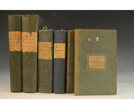
Lot 4222
Local Interest - Glover (Stephen): The History and Gazetteer of the County of Derby: Drawn up from Actual Observations, and from the Best Authorities; Containing a Variety of Geological, Mineralogical, Commercial and Statistical Information, Illustrated by a Map of the County, and Numerous Copper-Plate and Wood Engravings by the First Artists, two-volume set, Derby: Printed for the Publisher by Henry Mozley and Son [...], 1831-1833, contemporary green moiré boards as issued, the spines with publisher's paper labels, Plain Armorial bookplates to each pastedown: William Garnett, Esq., Bleasdale and Quernmore Park, Co. Lancaster, 4to, (2); the octavo edition, harlequin two-volume set, contemporary green cloth and moiré boards, 8vo, (2); The Directory of the County of Derby, Consisting Upwards of Fiteen Thousand Names [...], Alphabetically Arranged [...], Derby: Printed for the Publisher by Henry Mozley and Son [...], 1829, contemporary green cloth, upper-cover with publisher's paper label as issued, contemporaneous ink MS ownership inscription, 8vo, (1); The Peak Guide [...], with Plates and Pedigrees, Derby: Printed for the Publisher by Henry Mozley and Son [...], 1830, county map frontispiece, contemporary green cloth, upper-cover with publisher's paper label as issued, contemporary local bookseller's ticket to upper-left recto pastedown: Sold by J. Goodwin/Printer &c./Bakewell, 8vo, (1), [6]

Lot 4223
Local Interest - Kelly's 1876 Post Office Directory of Derbyshire, with Map Engraved Expressly for the Work, contemporary red cloth, 8vo, (1); Kelly's Directory of Derbyshire, two copies: 1881 & 1912, advertisements throughout each, contemporary red cloth as issued, 8vo, (2); Kelly's 1936 Directory of Derbyshire and Nottinghamshire, with Maps, contemporary red cloth, large 8vo, (1); Bulmer's 1895 History & Directory of Derbyshire, adverts, red cloth as issued, 8vo, (1); Melville & Co's 1854 Directory and Gazetteer for Leicestershire, red cloth as issued (almost disbound, spine lacking), 8vo, (1); Burke's 1937 Landed Gentry, centenary 15th edition, contemporary cloth gilt-lettered title and adverts, large 8vo, (1); Debrett's 1950 Peerage, Baronetage, Knightage, & Companionage, contemporary red cloth pictorial gilt, large 8vo, (1), [8]
![Local Interest - Lysons: (The Rev. Daniel) and (Samuel), Magna Britannia [...], Volume the Fifth, Containing Derbyshire, Lond](https://cdn.globalauctionplatform.com/b5d0520c-3f9d-4619-b761-abe600c55abf/a910bccb-2a4e-4091-9d5e-ac0500cb4c3a/468x382.jpg)
Lot 4224
Local Interest - Lysons: (The Rev. Daniel) and (Samuel), Magna Britannia [...], Volume the Fifth, Containing Derbyshire, London: Printed for T. Cadell and W. Davies, 1817, hand-coloured and b/w plates, later Victorian black quarter-calf over pictorial cloth, 19th century ink MS owership inscriptions, 4to, (1); Provincial Imprint, Davies (The Rev. D.P.), A New Historical and Descriptive View of Derbyshire, from the Remotest Period to the Present Time, Embellished with a Map and Plates, Belper: Printed and Published by and for S. Mason, 1811, 20th century half-calf over marbled boards, 8vo, (1); Pilkington (James), A View of the Present State of Derbyshire [...], two-volume set, Derby: Printed and sold by J. Drewry [...], 1789, institutional gilt-lettered leather over buckram, 19th century and later Liverpool Library stamps and bookplates, 8vo, (2); Britton (John) and Brayley (Edward Wedlake), The Beauties of England and Wales [...], Volume III only: Cumberland, the Isle of Man and Derbyshire, London: Printed by Thomas Maiden [...], 1802, full-page named-view antiquarian and topographical engravings, contemporary Regency polished calf, 8vo, (1); Britton (John, F.S.A.), The Beauties of England and Wales [...], Volume IX only: Lancashire, Leicestershire and Lincolnshire, London: Printed by Thomas Maiden [...], 1807, full-page named-view antiquarian and topographical engravings, slightly later quarter-calf over cloth, marbled edges, Plain Armorial Bookplate: Frederick Arthur Heygate (1857-1929), and his seat's library label with shelf numbering: Garratts Hall [Surrey] Library Case 1/VIII, 8vo, (1), [6]
![Newte ([Captain] Thomas), [pseud. of Thomson (William)], Prospects and Observations; On a Tour in England and Scotland: Natur](https://cdn.globalauctionplatform.com/b5d0520c-3f9d-4619-b761-abe600c55abf/a7e4588e-e337-44b7-85f9-ac0900f76c9a/468x382.jpg)
Lot 4236
Newte ([Captain] Thomas), [pseud. of Thomson (William)], Prospects and Observations; On a Tour in England and Scotland: Natural, Œconomical, and Literary, second edition: first edition titled thus, London: Printed for G.G.J. and J. Robinson, 1791, erroneous pagination and misbound but complete, pp: viii, 1-184 (83/84 & 85/86 bound out of order), 177- 296, 303-4, 299-302, 297-298, 305-440, fold-out map The Contour of Scotland engraved by John Cary (1754-1835) - but since the rebind cannot be now folded out, 21 full-page named-view topographical engravings, 20th century half-blue morocco gilt over marbled boards by Graham Bloodworth of Leicester, his ticket, a spine of six-compartments with gilt-lettered green morocco pieces in the second and fourth-compartments, the remainder with Tudor rose bosses, dated at the foot, raised bands, marbled endpapers, contemporary red-speckled edges, 4to, [1]

Lot 4239
Roads & Turnpikes - Hounslow & London, The New District, or Isleworth Turnpike Acts of Parliament, with A Correct List of the Trustees, Printed by Order of the Board of Trustees of the 10th Day of January, 1814, presentation copy to the treasurer-chairman of the trustees, Brentford: Printed by P. Norbury, 1815, pp: [iv], 106, [1], ten-fold copperplate engraved map frontispiece of the district, contemporary Regency calf (disbound, some losses), tooled in gilt and blind, marbled endpapers and edges, recto endpaper inscribed in ink MS: Presented to The Rev:d E[dward] Scott DD - The Treasurer & Chairman, later ownership inscription: W Scott_ (?the son), 8vo, (1); Springwood Park Copy, Parnell (The Right Honourable Sir Henry, Bart), A Treatise on Roads [...], London: Printed for Longman [...], 1833, pp: xii, 438, 7 fold-out engraved plates to recto, contemporary half-calf over marbled boards, Plain Armorial bookplate: Sir George Douglas, his ancestral seat's library label: Springwood Park, Kelso, [Scotland], 8vo, (1); McAdam (John Loudon), Remarks on the Present System of Road Making [...], fifth edition, London: Printed for Longman [...], 1822, the whole prefixed by a 16pp Whittaker's catalogue of latest publications, original publisher's boards, 8vo, (1); Digests of the General Highway and Turnpike Laws [...], An Appendix on the Construction and Preservation of Roads by John Scott [...], London: Printed for Edward and Charles Dilley, 1778, contemporary publisher's boards only, 8vo, (1); A Collection of the Acts of Parliament Now in Force for Regulating the Turnpike Roads in Englands, with a Copious Index, London: Printed by George Eyre and Andrew Spottiswoode, 1837, rebacked publisher's boards, 8vo, (1); another earlier copy, London: 1823, publisher's boards (disbound), 8vo, (1), [6]
![Topography - Anon, [Cumming (John)], The Traveller's New Guide through Ireland [...], Illustrated with a New and Accurate Map](https://cdn.globalauctionplatform.com/b5d0520c-3f9d-4619-b761-abe600c55abf/f1939728-159b-477e-a52a-ac0200e7815c/468x382.jpg)
Lot 4248
Topography - Anon, [Cumming (John)], The Traveller's New Guide through Ireland [...], Illustrated with a New and Accurate Map of Ireland, Plan of the Lakes of Killarney - Views of the Giant's Causeway - Delineations of the Principal Post-Roads - with Other Plates, London: Published by Longman [...], 1819, pp: 4, 574, 22 full-page plates, 1 fold-out map, 1 fold-out plan, contemporary blue half-leather over marbled boards, blue-speckled edges, 8vo, (1); Baker (J[ames]), The Imperial Guide, with Picturesque Plans of the Great Post Roads, Containing Miniature Likenesses, Engraved from Real Sketches [...], London: Printed for C. Whittingham [...], 1802, pp: iv, 66, additional stipple engraved title-page as issued, 17 full-page tiered monochrome named-views, 16 full-page monochrome aquatint landscapes and 1 extra-illustrated engraving, contemporary calf boards gilt, rebacked and lettered in gilt, contemporary marbled endpapers, contemporary armorial bookplate: Right Hon:ble Lord Keith, K.B., Vice Adml. F.R.S., [as Baron Keith, subsequently Admiral of the Red George Keith Elphinstone, 1st Viscount Keith GCB (1746 - 1823)], 8vo, (1), [2]
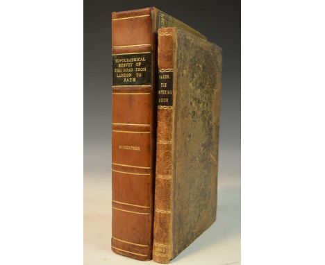
Lot 4251
Topography - Grangerised Copy, Robertson (Archibald), A Topographical Survey of the Great Road from London to Bath and Bristol, with Descriptive Accounts [...], Illustrated by Perspective Views of the Most Select and Picturesque Scenery, To which is added A Correct Map of the Country [...], two-parts in one volume, London: Printed for the Author [...], 1792, pp: [2], xv, [i], iii-vii, [i], 154, 190, [1], 65 full-page monochrome aquatints, panoramic travelling road map on 11 sheets, extra-illustrated with 19 plates of mixed media and date, contemporary diced calf boards gilt to a Regency design, later 19th century rebacking in calf gilt-lettered and ruled, marbled edges and endpapers, contemporary Plain Armorial bookplate: Richard Nixon, 8vo, (1); Baker (J[ames]), The Imperial Guide, with Picturesque Plans of the Great Post Roads, Containing Miniature Likenesses, Engraved from Real Sketches [...], London: Printed for C. Whittingham [...], 1802, pp: iv, 66, additional stipple engraved title-page as issued, illustrated with 20 full-page tiered named-views with contemporary hand-colouring and 10 monochrome aquatint landscapes, contemporary calf boards rebacked to style, contemporary Plain Armorial bookplate: R. Stephenson, 8vo, (1), [2]
![Topography and Antiquarianism - Gorton (John), A Topographical Dictionary of Great Britain and Ireland [...], three-volume se](https://cdn.globalauctionplatform.com/b5d0520c-3f9d-4619-b761-abe600c55abf/507b142a-bbae-4a34-8007-ac0500cb5351/468x382.jpg)
Lot 4252
Topography and Antiquarianism - Gorton (John), A Topographical Dictionary of Great Britain and Ireland [...], three-volume set, London: Chapman and Hall, 1833, lacking all maps, institutional buckram, Plain Armorial bookplates, 8vo, (3); [Bertram (Charles)], The Description of Britain, Translated from Richard of Cirencester: with The Original Treatise De Situ Britanniæ; and a Commentary on the Itinerary; Illustrated with Maps, first English edition, London: Printed for J. White and Co., 1809, pp: xxiii, 127, [1], 2 fold-out maps and 1 engraved plate, contemporary diced calf boards only (upper-cover loose, lacking spine, marbled endpapers, contemporary book label to recto pastedown: H. Hatcher, Salisbury, 8vo, (1); West (W[illiam]), The History, Topography and Directory of Warwickshire [...], Illustrated with Characteristic Etchings and a Map of the Country, Birmingham: Printed and Published by R. Wrightson, 1830, publisher's boards, 8vo, (1); Reminiscences of Old Sheffield, Its Streets and Its People, Edited by Robert Eadon Leader, second edition, Sheffield: Leader and Sons, 1876, contemporary green cloth, 8vo, (1); Crump (W.B.), Huddersfield Highways Down the Ages, Huddersfield: The Tolson Memorial Museum, 1949, pictorial d/j and h/b, 8vo, (1); further Yorskhire interest; Scotland; Manchester; Alienated Tithes [...], Compiled from Official Sources by Henry Grove [...], London: Printed for the Author's Subscribers, 1896, blue cloth, 8vo, (1); muniments and records; pamphlets; etc., [21]
![Topograpy - Cooke (George Alexander), Cooke's Topographical and Statistical Description[s] [...], Illustrated with a Map[/Map](https://cdn.globalauctionplatform.com/b5d0520c-3f9d-4619-b761-abe600c55abf/c4e3520c-df34-4d99-888a-ac0500cb53e4/468x382.jpg)
Lot 4253
Topograpy - Cooke (George Alexander), Cooke's Topographical and Statistical Description[s] [...], Illustrated with a Map[/Maps] of the County, Island or Regional Division, [n.d., 1800-1830], comprising 13 volumes bound en suite: Wiltshire, Dorset, General Description of Scotland, Southern Scotland (as 2), Middle Division of Scotland (as 2), Oxford, Cambridge, Northumberland, Durham, Nottingham, the British Isles, each bound in redecorated or repaired marbled boards, some titles still lettered in ink MS, contemporary Neoclassical ribbon-tied black ink ownership stamp: I.L. Camroux, (13); others, Sussex & Gloucester, bound as one, and, the British Isles & Hereford, bound as one, contemporary red calf gilt over marbled boards, the spines with Adamesque paterae, (2); Warwick, contemporaneous blue cloth, (1), all 12mo, [16]
Lot 4256
Travel, Topography and Husbandry - Irish Imprint, Young (Arthur), Travels, During The Years 1787, 1788 and 1789, Undertaken more particularly with a View of ascertaining the Cultivation, Wealth, Resources, and National Prosperity, of the Kingdom of France [...], first Irish edition, matched two-volume set, Dublin: Printed for Messrs. R. Cross [...], 1793, pp: xvi, 681, 1 fold-out engraved map frontispiece; [ii], 571, [3], fold-out engraved soil map with contemporary hand-colouring frontispiece, another fold-out engraved map, harlequin contemporary calf, contemporary indistinct ink MS ownership to volume I, another with volume II: John Lindesay of Loughry, [County Tyrone, Ireland], 8vo, (2); [Young (Arthur)], A Six Months Tour through the North of England [...], volumes I, III & IV only, first edition, London: Printed for W. Strahan [...], 1770, fold-out engraved plates and maps, contemporary calf, contemporary ink MS ownership inscriptions to each endpaper: Edw:d Williams, slightly later Neoclassical Armorial bookplates to each pastedown: W: Pigott, LL.B., 8vo, (3); [Kearsley (George)], Kearsley's Traveller's Entertaining Guide through Great Britain [...], second edition, London: Printed for G. Kearsley [...], 1803, fold-out enrgaved map laid on linen, 20th century brown half-morocco gilt over cloth, 8vo, (1); Provincial Imprint, Warner (Revd. Richard), A Tour through the Northern Counties of England, and the Borders of Scotland, Bath: Printed by R. Cruttwell [...], 1802, the Derbyshire excerpt only, pp: [iv], pages 97-98, 147-162, disbound, cloth-backed boards covers, 8vo, (1); Guthrie (William), A New Geographical, Historical, and Commercial Grammar [...], volume I only, fifth edition, London: Printed for J. Knox, 1774, fold-out hand-coloured engrvaved maps, contemporary calf, 8vo, (1), [8]
Lot 4257
Travel, Topography, Roads and Turnpikes - Paterson (Daniel): A New and Accurate Description of all the Direct and Principal Cross Roads in England and Wales [...], fifth edition, London: Printed by T. Carnan [...], 1781, two-page map, contemporary calf, upper-cover with a red morocco gilt-lettered piece, 8vo, (1); a later copy, seventh edition, 1786, contemporary speckled calf over marbled boards, vellum corner, contemporary ink MS ownership inscription: R.N.H. Wyatt, 8vo, (1); A Travelling Dictionary: or, Alphabetical Tables [...], fifth edition, London: Printed by Thomas Carnan [...], 1787, relaid contemporary calf, 20th century Pictorial bookplate: Ex Libris John E. Pritchard, Bristol, 8vo, (1); Paterson's Roads, in a Pocket Size, for the Convenience of Travellers on Horseback [...], London: Printed for the Proprietor [...], 1804, contemporary black half-calf over marbled boards (loose upper-cover, losses to spine), contemporary ink MS ownership inscription: Edward Charles Rudge, another later and dated 1881, 8vo, (1); Paterson's Roads, six copies, comprising fifteenth edition, London: 1811, contemporary calf over boards; Admiral Tollemache's Copy, sixteenth edition, London: 1822, contemporary calf over marbled boards by W. Houghton, Twelve Years with & Sucessor to Mr Wrangham, Stationer, &c., 161 New Bond St., [London], his ticket, contemporary dated ink MS ownership inscription: Admiral [John] Tollemache (née Halliday) 1823, & later Plain Armorial Tollemache bookplate; seventeenth edition, London: 1824, contemporary calf over marbled boards, ink MS ownership inscriptions: N. Charrington/Mile End; eighteenth edition, London: 1826, map printed on India paper, contemporary calf by G. Batenham of Chester, his ticket, slightly later dated ink MS ownership inscription: Henry Dudley Ryder [...] April 1831 [?1777-1836, Bishop of Lichfield], later Plain Armorial bookplate: William Garnett, Esq., Bleasdale and Quernmore Park, Co. Lancaster, 8vo, (1); another copy, drab calf gilt, marbled endpapers, Neoclassical Armorial bookplate: Geo. Lucas Esqr [?of Elmwood House, Hertfordshire]; another copy in publisher's boards, all 8vo, (6); Ogilvy (David, Jun), A General Itinerary of England and Wales, with Part of Scotland [...], London: Printed for G. & J. Robinson [...], 1804, publisher's boards, contemporary ink MS ownership inscription: Charles Lloyd, 8vo, (1), [11]
![Cartography - [Cary (John)], Cary's New Map of England and Wales with part of Scotland on which are carefully laid down all t](https://cdn.globalauctionplatform.com/b5d0520c-3f9d-4619-b761-abe600c55abf/fe48401b-c353-4391-bbe5-ac0200e7860c/468x382.jpg)
Lot 4278
Cartography - [Cary (John)], Cary's New Map of England and Wales with part of Scotland on which are carefully laid down all the Direct and Principal Cross Roads, the Course of the Rivers and Navigable Canals [...], first edition, London: 1794, pp: [3], 82 sheets of copperplate engravings with contemporary hand-colouring and/or delineation, contemporary calf travelling envelope wrap with a brass clasp, enclosing a calf spine over a marbled upper-cover (contents folded), 4to, [1]
-
108737 item(s)/page