We found 109198 price guide item(s) matching your search
There are 109198 lots that match your search criteria. Subscribe now to get instant access to the full price guide service.
Click here to subscribe- List
- Grid
-
109198 item(s)/page


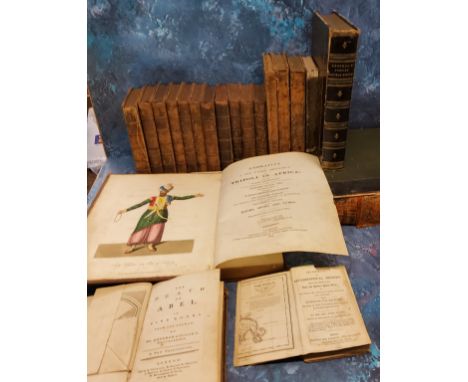
Lot 121
TULLY (R) Narrative of a Ten Years' Residence at Tripoli in Africa: from the original correspondence . . . comprising authentic memoirs & anecdotes of the reigning bashaw . . . also, an account of the domestic manners of the Moors, Arabs, and Turks. 2nd edition. folded map & 4 hand-coloured aquatint plates, 4to. 1817; Cassell's Concise Natural History Being A Complete Series of Descriptions of Animal Life, E Perceval Wright; The Harmsworth Atlas, folio; The Spectator, in 8 volumes, London 1744, printed for J and R Tonson in the Strand; other bindings


Lot 1452
Album of Photographs from 1920's/30's, depicting wartime tours of Cyprus, Egypt and Palestine, beautifully presented and mounted, with a map of the position of TSS Aeneas daily at noon. Together with a quantity of loose photographs. This is a wonderful collection of great historical interest.


Lot 176
Johann Heinrich Tischbein d. Ä., 1722 Haina – 1789 KasselGemäldepaarLANDGRAF FRIEDRICH II VON HESSEN-KASSEL (1720 - 1785) sowiePRINZESSIN CHRISTINE CHARLOTTE VON HESSEN-KASSEL (1725 - 1782)Öl auf Leinwand.144 x 112 cm.Das Herrenportrait ist rückseitig oben links bezeichnet und datiert „Tischb. 1765 Kurfürst von Hessen“.In Rokokorahmen, die dem Innenarchitekten und Dekorationsbildhauer Johann August Nahl d. Ä. (1710 Berlin - 1785 Kassel) zugeschrieben werden. Dieser war seit 1755 in Kassel tätig.Der Souverän in Dreiviertelfigur nach links in blauem, reich besticktem Uniformrock dargestellt mit Band und Stern des englischen Hosenbandordens. Neben ihm ein kleiner Tisch, darauf sein Dreispitz und eine Kupferstichkarte, dahinter eine Vorhangdraperie. Christine Charlotte als Kniestück, den Kopf nach links gewandt, mit Band und Stern des russischen Katharinenordens vor Vorhangdraperie. Die Prinzessin hält die Pfote ihres Schoßhündchens, der auf einem Sessel steht. Dessen Halsband mit Bezeichnung C.P.Z.H: Christine Prinzessin zu Hessen. Als Cousine des Landgrafen Friedrich II war sie nach dessen Trennung von seiner Gemahlin im Jahre 1754 die ranghöchste Dame am Kasseler Hof und kam bis 1773 den Repräsentationsaufgaben der ehemaligen Landgräfin nach. Ab 1766 bekleidete sie das Amt einer Koadjutorin der Förstabtei Herford.Provenienz:Familie des Johann Jacob von Uckermann (ehemals Hessischer Geheimrat, Schloss Weesenstein, Bedeleben).Bis 1945 im Besitz der Uckermann‘schen Nachfahren auf Schloss Luttowitz bei Bautzen.1945 im Rahmen der Bodenreform enteignet mit Übergang in den Besitz der Gemäldesammlung Alte Meister, Dresden.2008/2009 Restitution an die Erben der rechtmäßigen Eigentümer.Anmerkung:Ein weiteres Portrait der Prinzessin befindet sich im Besitz der Hessischen Hausstiftung, Museum Schloss Fasanerie, Eichenzell. Eine weitere Version findet sich auf Schloss Kronberg (signiert und datiert 1765).Literatur:Das hier angebotene Gemäldepaar ist aufgeführt im Werkverzeichnis: Anna-Charlotte Flohr, Johann Heinrich Tischbein d.Ä. (1722 - 1789) als Porträtmaler. Mit einem kritischen Werkverzeichnis, München 1997, S. 176, WVZ-Nr. G14 (Landgraf) und G41 (Prinzessin), mit Abb. (1370346) (13)Johann Heinrich Tischbein the Elder,1722 Haina – 1789 KasselA pair of paintingsFREDERICK II, LANDGRAVE OF HESSE-KASSEL (1720 - 1785) and HIS COUSIN PRINCESS CHRISTINE CHARLOTTE OF HESSE-KASSEL (1725 - 1782)Oil on canvas.144 x 112 cm.The portrait of the gentleman is inscribed and dated top left on the reverse: Tischb. 1765 Kurfürst von Hessen.In Rococo frame, attributed to the interior architect and decorative sculptor Johann August Nahl the Elder (1710 Berlin - 1785 Kassel). He was active in Kassel since 1755.The sovereign is shown in three-quarter length portrait to the left, in a blue, richly embroidered tunic, with the ribbon and star of the Order of the Garter. Beside him a small table, on it his tricorn and a copperplate map, with drapery in the background. Christine Charlotte is shown in knee-length portrait, her head turned to the left, with the ribbon and star of the Russian Order of Saint Catherine in front of curtain drapery. The princess holds the paw of her pet dog, who is standing on an armchair. His collar with the inscription C.P.Z.H: Christine Princess of Hesse.Literature: The pair of paintings on offer for sale in this lot are listed in the catalogue raisonné: Anna-Charlotte Flohr, Johann Heinrich Tischbein d. Ä. (1722 - 1789) als Porträtmaler, mit einem kritischen Werkverzeichnis, Munich 1997, p. 176, catalogue no. G14 (Landgrave) and G41 (Princess), with illustration.

Lot 333
Bryant, Andrew, British, fl.1822-1835, Map of the county of Norfolk from Actual Survey by A. Bryant, In the Years 1824, 25 & 26, Respectfully Dedicated to the Nobility, Clergy & Gentry of the County, Published by A. Bryant, 27 Great Ormond Street, London, Dec 1st, 1826, in two parts, North and South, hand-coloured, dissected and backed on linen, with vignette of Norwich Cathedral, each part 71 x 227cm, in a contemporary leather slip case

Lot 334
Lizars' Edinburgh Geographical General Atlas: Containing Maps of Every Empire, State and Kingdom; with a Tabular View of the Heights of the Great Mountain Chains....., 67 double-page engraved maps, hand-coloured in outline, missing no.9 British Islands, with one double-page uncoloured 'Table of Mountain Chains' map, half-leather boards detached, Edinburgh: W. H. Lizars, 3 St James' Square, S. Highley 32 Fleet Street, London; and W. Curry, Jun., & Co., Dublin, c.1842 Footnotes: Note: Includes two rare maps depicting the Republic of Texas between its secession from Mexico in 1836 and its annexation in 1845. The map of Mexico & Guatimala (sic) with the Republic of Texas bears ink inscription to lower right.
Lot 336
Coronelli, Vincenzo Maria, 1650-1718, America Settentrionale Colle Nuove Scoperte fin all' Anno 1688, engraved map on two joined sheets of laid paper, with later hand-colouring, V. M. Coronelli, Venice, c.1690, each sheet approx. 61 x 44.2cm, total 61 x 88.5cm, frame 87.2 x 114cm Footnotes: Note: Vincenzo Maria Coronelli was an Italian Franciscan friar, cosmographer, cartographer, publisher, and encyclopaedist, who became one of the most celebrated globe and map makers of his era. He produced over one hundred terrestrial and celestial globes, hundreds of maps and large numbers of cartographic publications. He completed the Marly Globes for Louis XIV in 1683, which are considered some of the most magnificent globes ever produced. He founded the first geographical society, the Accademia Cosmografica degli Argonauti in Venice in 1684, which had immense success, enrolling some 200 members from all of Europe by 1693. He published the Atlante Veneto,1691, and the Isolario, 1696-98, and compiled the first encyclopaedia to be arranged alphabetically.This map of North America, first published in the Atlante Veneto, was considered to be one of Coronelli's finest maps. The most prominent geographical detail is California's appearance as a massive island, this map being one of the best renderings of this misconception. Based on Sanson's 1669 map, with the addition of mountain ranges and place names. "It provided a major leap in the cartography of the day. The whole is aesthetically delightful, providing a perfect balance between the provision of scientific accuracy and beauty'' (Burden 643). McLaughlin 103; Tooley, p. 125 and 306. Condition Report: In good condition, however please note the following observations: mounted in a frame with UV acrylic glass and has been examined out of the frame. The top of the sheet is attached to the underside of the mount with four pieces of tape along the top of the sheet and three along the bottom. There is a further piece of tape to top of centre and a minor tear to upper right top edge seen from the reverse that has been covered with tape. Another short piece of tape to upper right edge. Pencil inscription to reverse a top right and lower right. Seen from the front, margins visible about 1cm all around from sight edge of mount to flat mark, approx. 2cm to left margin. Some ruckling along the centre fold to lower right and centre left, crease to lower right below Isola Spagnuola and ruckling to upper and lower right. Horizontal soft crease to lower left section. Very small piece of fibrous brown coloured paper to lower edge of central crease. Crease or tear visible to upper left top edge which corresponds to tape on the reverse. Colouring is later. When the two sheets were joined they are slightly out of line and as such the scale on both sheets along centre are no longer visible.


Lot 93
2 CLASSIC MALT MINIATURE SETS (13 X 5CL) SINGLE MALT Cragganmore 12 Year Old - 40% ABV / 5cl x 2Dalwhinnie 15 Year Old - 43% ABV / 5cl x 2Glenkinchie 10 Year Old - 43% ABV / 5cl x 2Oban 14 Year Old - 43% ABV / 5cl x 2Talisker 10 Year Old Map Label - 45.8% ABV 5cl x 2Lagavulin 16 Year Old White Horse - 43% ABV / 5cl x 2Blair Athol 8 Year Old - 40% ABV / 5cl Qty: 2

Lot 148
Herman Moll (circa 1654-1732) Antiquarian Map of Gloucestershire, with illustrations of British coins to the margin, 19.5cm x 31.5cm together with Robert Morden, engraved Map of Gloucestershire, possibly 18th Century, 35cm x 42cm and another map of Gloucestershire, 56cm x 56cm (3)Provenance: From the Property of a Gentleman, from a Period Winchcombe Town House. All with overall wear consistent with age and use. All have discolouration and folds/creases. Some maps with foxing. Morden map with a slightly loose frame. Largest map with losses and unidentifiable foreign objects under glass. Please note that maps have not been removed from frames to be examined.

Lot 149
British Isles, Magnae Britanniae et Hiberniae Nova Descriptioengraving, with decorative cartouche throughout, with later colour details, 44cm x 55.5cmProvenance: From the Property of a Gentleman, from a Period Winchcombe Town House. Overall wear consistent with age and use. Tear through the centre. Further tears/losses. With discolouration. With foxing. With folds and creases. Ink spot in the margin. Some marks and stains to the back of the frame. Please note that map has not been removed from frame to examine.


Lot 147
After Anselm van Hulle (1601-1674) 'Portrait of Hugo Fredericus, Ambassador of Trier', engraving, 32cm x 21cm, Thomas Kitchin (1719-1784), Antiquarian map aerial plan of Gloucestershire, engraving, 17cm x 22cm, Robert Morden (1659-1703) Gloucestershire, aerial plan of the Country, engraving, 18.5cm x 23cm, a reverse glass print of George I, 29cm x 24cm, two reverse glass printed coaching scenes, one by F Rosenberg, painted by J Pollard, published October 8th 1830 by J Watson, London, 'A Scene on the London to Portsmouth Road going Through Emsworth', 26cm x 34cm, and one other by the same artist, published May 22nd 1830 by J Watson, London, 'A Scene on the London to Brighton Road, First Stage', 26.5cm x 34cm and a carved hardwood frame for a painting, 32cm x 28cm (7)Provenance: From the Property of a Gentleman, from a Period Winchcombe Town House.

Lot 121
A Taxco silver gilt abalone panel bracelet,with engraved panels alternating to bead decorated panels, all set with abalone, to concealed clasp, engraved 'Hecho En Mexico D.F.', marked MAP, sterling 925 Taxco, together with a pair of Taxco silver cufflinks, by Sigi Pineda, Taxco,and a tie bar clip, of similar design, marked 'Sterling Hecho En Mexico no.46'.79.45g (4)Condition ReportTarnish to the bracelet.Scratches to the abalone sections.Tarnish to the cufflinks and tie bar.Bracelet 185mm in length (excluding the clasp tongue), panels about 28mm to 31mm wide.


Lot 183
Hudson (Rev. William) How the City of Norwich Grew Into Shape, Norwich, Agas H. Goose, 1896, illustrated by five maps; together with Bacon's Twentieth Century Map of East Anglia, cloth backed and boards; A.M.C. Guide to Norwich 1901, gilt blue cloth boards; with four other publications (7) Provenance: Barbara & Martin Miller Collection


Lot 732
Graham Thomas Oakley (British, 1929-2022), Sampson the cat and the church mice looking at a map, watercolour, unsigned, 15 x 26 cm, (unframed) Provenance: From the estate of the late Graham Thomas Oakley deceased Graham Oakley is best known for the Church Mice series of picture books (1970-2000), next to the Foxbury Force series (1994-1998) Please note these are sold without copyright


Lot 332
Vambery (Herrmann). The Toorkmans and their position towards Russia, translated from the German by C.U.A, Calcutta: Printed at the Foreign Department Press, 1874, 20 pp., original front paper wrapper bound in, pencilled marginalia, modern red buckram gilt, 8vo, together with:Kuhn (A.L). Report of a Journey Through the Khanate of Khiva during the Expedition of 1873, Calcutta: Printed at the Foreign Department Press, 1874, 12 pp., title lightly spotted, pencilled marginalia, modern red buckram gilt, 8vo, withOlim (Transindicus). The Cabul Question, being a detail of Central Asian events bearing on the question, and of geographical and other statistics connected with it. Also a discussion of the policy hitherto pursued with reference to Affghanistan and of that which is now advisable to follow, London: Strangeways and Walden, 1869, 43 pp., folding map of Central Asia, title lightly spotted, modern blue buckram gilt, 8vo, with 4 other related works, H.B. Edwardes 'Memorandum on the Report of the Candahar Mission in 1858' (1868), P. Lerch 'Russian Toorkestan; Its People & External Relations' (1874), P. Lerch 'Khiva or Kharizm; Its Historical and Geographical Relations' (1873), and an anonymous work entitled 'The Russians in Central Asia, reprinted from the Quarterly Review, October 1865' QTY: (7)
Lot 135
Snelgrave (William). A New Account of Guinea, and the Slave-Trade, containing I. The History of the late Conquest of the Kingdom of Whidaw by the King of Dahome. The Author's Journey to the Conqueror's Camp; where he saw several captives sacrificed, etc. II. The Manner how the Negroes became Slaves. The Numbers of them yearly exported from Guinea to America. The Lawfulness of that Trade. The Mutinies among them on board the Ships where the Author has been, etc. III. A Relation of the Author's being taken by Pirates, and the many Dangers he underwent, London: printed for J. Wren, 1754, folding engraved map of the coast of Guinea (some offsetting to title), some toning to endpapers, Mission House Library label and manuscript shelf number to map verso, contemporary calf, modern calf reback with morocco label, corners repaired, 8voQTY: (1)NOTE:ESTC T136168. A re-issue of the 1734 first edition with a cancel title. Snelgrave was an active slave-trader from 1704 to 1734; his book justifies and defends the trade and contains an account of his capture by pirates in 1719.
![[Byron, John]. A Journal of a Voyage Round The World, in his Majesty's Ship The Dolphin, Commanded by the Honourable Commodor](https://cdn.globalauctionplatform.com/58f83210-d8be-44f6-bb81-b06d011764e4/6b5e04f5-880d-4fd3-9723-b07600e66db9/468x382.jpg)
Lot 144
[Byron, John]. A Journal of a Voyage Round The World, in his Majesty's Ship The Dolphin, Commanded by the Honourable Commodore Byron. In which is contained, a faithful account of the several places, people, plants, animals &c. Seen on the voyage: and, among other particulars, a minute and exact description of the streights of Magellan, and the gigantic people called Patagonians. Together with an accurate account of the seven islands lately discovered in the South Seas, London: M. Cooper, 1767, 24, [28], 25-75, engraved folding map frontispiece, lacking the engraved plate, contains the 28 page insert, final two lines of p.24 erased by printer (as usual), all edges gilt, modern red morocco gilt, endpapers and blanks renewed, 8voQTY: (1)NOTE:Provenance: The Library of Franklin Brooke-Hitching, Part 1, Sotheby's, 27 March 2014, lot 231 (his pencilled initials to front blank).ESTC T67285.Exceedingly scarce, with ESTC listing seven copies. Extant copies are often incomplete, with the British Library copy lacking the plate and the Bodleian copy lacking both the plate and the map.An unofficial account of John Byron's circumnavigation. During the voyage, Byron took possession of the Falklands, as well as visiting the Gilbert Islands and the Marianas. The 28-page insert contains an elaborate account of the 'Patagonian Giants'.

Lot 125
Betagh (William). A Voyage round the World. Being an account of a Remarkable Enterprize, begun in the year 1719, chiefly to cruise on the Spaniards in the great South Ocean. Relating the true historical facts of that whole affair: testifyd by many imployd therein; and confirmed by Authorities from the Owners, 1st edition, London: Printed for T. Combes, J. Lacy and J. Clarke, 1728, folding engraved double-hemisphere world map, bookplate of Robert Myddelton, Esq. Gwaynynog to front pastedown, modern half calf over old marbled boards and endpapers, red edges, slightly spotted, 8vo (196 x 116mm)QTY: (1)NOTE:Provenance: Robert Myddelton of Gwaynynog, Lieutenant Colonel of the Denbighshire Militia.Borba de Moraes p.104; Hill (2004) 123; Sabin 5057.'One of the most important of the buccaneering expeditions' (Hill). The work includes An Account of the Jesuits settlement in the province of Paraguay in South America. Translated from the French.First edition of Betagh's account of the privateering expedition aboard the Speedwell with Captain Shelvocke. Shelvocke wrote his own narrative of the voyage in which Betagh is cast in a unfavourable light. Here he does his best to discredit Shelvocke while also providing observations of the countries he visited and the people he encountered. 'Betagh describes... the Spanish dominions of Chile and Peru, where he observed the customs of the Creoles and the techniques of gold and silver mining and refining. Baja California and Macao were also visited. Clipperton Island, off the west coast of Mexico, was discovered and named after Captain Clipperton' (Hill).

Lot 161
Keate (George). An Account of the Pelew Islands, situated in the Western Part of the Pacific Ocean, composed from the journals and communications of Captain Henry Wilson, and some of his officers, who in August 1783, were there shipwrecked, in the Antelope, 1st Dublin edition, Dublin: Luke White, 1788, engraved portrait frontispiece, folding engraved chart (repaired tear to verso), 15 engraved plates, marginal water stain to frontispiece and title, some light offsetting, small bookplate of Charles M. Hutt, front hinge tender, contemporary tree calf, some worming to upper joint, spine rubbed, 8vo, together with Forester (Thomas). Norway in 1848 and 1849: containing rambles among the fjelds and fjords on the Central and Western Districts, 1st edition, London: Longman, Brown, Green and Longmans, 1850, double-page map, 5 colour lithograph plates, occasional light spotting, contemporary inscription at head of title, contemporary green half morocco, rubbed and scuffed, 8vo, plus Bell (Charles). The People of Tibet, 1st edition, Oxford: Clarendon Press, 1928, 3 maps (2 folding), half-tone illustrations, light spotting to rear map, original cloth gilt, 8vo, with other travel including Narrative of a Visit to the Courts of Russia and Sweden, in the years 1830 and 1831, byC. Colville Frankland, 2 volumes, 1st edition, 1832 (lacking plan to volume II), The Invasion of Crimea, by Alexander William Kerslake, volumes I & II only (of 8), 1863, Free Russia, by William Hepworth Dixon, 2 volumes, mixed editions,1870, A Narrative of the Discovery of the Fate of Sir John Franklin and his Companions, by Francis M'Clintock, 1st edition, 1859 (lacking map of the Arctic Regions at end), History of the Ottoman Turks, by E. S. Creasy, new edition, 1858, The Ascent of Everest, by John Hunt, 1st edition, 1953, and A History of Exploration, by Percy Sykes, Edition de luxe 103/200, 1950QTY: (32)NOTE:Provenance: W. A. Foyle, Beeleigh Abbey.
Lot 145
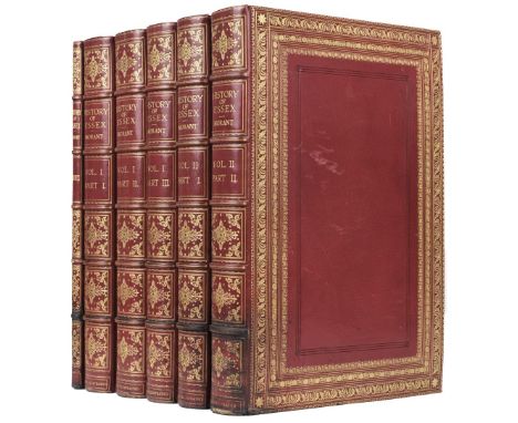
Morant (Philip). The History and Antiquities of the County of Essex, 2 volumes, (incorporating the second edition of The History and Antiquities of the most ancient Town and Borough of Colchester), London: T. Osborne et al., 1768, EXTRA ILLUSTRATED AND EXTENDED TO 5 VOLUMES, plus a Manuscript Index, 1908, the contents mounted on large paper, the whole being lavishly extended with hundreds of extra illustrations of varying sizes, containing approximately 36 maps, some coloured, including examples by or after Christopher Saxton, Johannes Blaeu, Jan Jannson, John Chapman and Peter Andre, Philip Lea, Thomas Dix, Ordnance Survey, Richard Blome and Robert Morden, plus approximately 20 watercolours and drawings and 750 prints including portraits and views, coloured aquatints by Havell and Merigot, other coloured plates by Alken and Daniell, mezzotints by J. Smith, C. Turner, J. Faber and McArdell, lithographs, stipple etchings, line engravings, india proofs, woodcuts, facsimiles, etc., the five text volumes with additional printed title-pages for this unique copy dated 1908, the manuscript Index volume comprising 24 leaves (plus 18 blank), completed alphabetically in a very neat hand on rectos only, burgundy morocco gilt bookplate of W. A. Foyle, Beeleigh Abbey to all front pastedowns, early 20th-century red crushed levant full morocco gilt by Morrell, inner dentelles gilt, wide and richly roll-tooled panels in gold and blind, gilt-decorated spines with raised bands, Index volume bound in red crushed levant half morocco gilt to match, all with some slight rubbing and a few scuff marks, some darkening from old scorch marks to lowest raised bands and foot of spines and board edges, a little wear and some strengthening to tailcaps, folio (560 x 385 mm)QTY: (6)NOTE:Provenance: W. A. Foyle, Beeleigh Abbey (bookplates).A truly sumptuous and very handsome imperial folio set of this major county history. The contents are largely in very clean and good condition and the whole has been assembled with fastidious care. Sadly, there is no evidence as to who it was done by or who owned it before William Foyle.The maps include those by Christopher Saxton, Johannes Blaeu, Jan Jannson, Emanuel Bowen (7), John Norden and W. Kip, C & J Greenwood, Philip Lea, John Rocque, Henry Overton, Robert Morden, Richard Blome, Thomas Kitchin, John Cary, James Pigot, J. Roper and Thomas Dix, plus a large-scale 25-sheet map by John Chapman & Peter Andre (220 x 285 cm), and a 4-sheet county map by Colonel Mudge (OS maps), and a large-scale county map by C. & J. Greenwood.There are watercolour views of Woodford by W. H. Bartlett, 1832, (330 x 495 mm); St Botolph's Priory by G. F. Phillips, 1807; Mr Trott's Farm near Romford by J. C. Nattes; Great Canfield by A. Barfield, 1844; large sepia wash drawing of Nether Hall [by Laporte]; large plan of Colchester Barracks by J. Parkyns, 1806; unsigned views of Waltham Abbey, Tilty Abbey, Thaxted (pencil), Southend (2), South Bemfleet (sepia), House of Mrs Masson at Hornchurch; plus portraits of Lady Anne Lucas by T. Athow, Thomas Littleton and Sir Thomas Hervey (fine copy).Among the numerous portraits are approximately 14 mezzotints of Oliver Cromwell (trimmed to oval), George Capel, Earl of Essex, James I, Duke of Albemarle, Admiral Sir George Pocock, Samuel Bosanquet (relined; not in Index), Bishop Compton, Lady Fairfax (small), John Knight and family, Thomas Wood, Edward Bright, Henry Vane, John Morley and Thomas Lane.

Lot 226
Barrow (John). A Chronological History of Voyages into the Arctic Regions; undertaken chiefly for the purpose of discovering a North-East, North-West or Polar Passage between the Atlantic and Pacific: from the earliest periods of Scandinavian navigation, to the departure of recent expeditions, under the orders of Captains Ross and Buchanan, 1st edition, London: John Murray, 1818, half-title, folding engraved map, 3 illustrations in Appendix at rear, occasional light offsetting and toning, burgundy morocco gilt bookplate of W. A. Foyle, armorial bookplate of FitzRoy Keith Chapman, front hinge tender, all edges yellow (top edge faded), later tan calf by Bedford, spine with red morocco labels and decorated in gilt, 8vo, together with Voyages of Discovery and Research within the Arctic Regions, from the year 1818 to the present time: under the command of the several naval officers employed by sea and land in search of a North-West Passage from the Atlantic to the Pacific; with two attempts to reach the North Pole, 1st edition, London: John Murray, 1846, engraved portrait frontispiece, 2 engraved charts (one folding), a few light spots, bookplates as above, uniformly bound by Bedford, 8vo QTY: (2)NOTE:Provenance: W. A. Foyle, Beeleigh Abbey (bookplates).Sabin 3660 & 3669 respectively. First book 'An elaborate work written while the author was Secretary to the Admiralty, with full command of the needful materials.' (Sabin).

Lot 292
Butler (John). A Sketch of Assam: with some account of the Hill Tribes. By an Officer in the Hon. East India Company's Bengal Native Infantry in civil employ. With illustrations from sketches by the author, 1st edition, London: Smith, Elder and Co., 1847, viii + 220 pages, 32pp. publisher's catalogue at end, with contemporary related newscuttings pasted to the first page of advertisements, 17 lithograph plates including 16 hand-coloured, 4 wood engravings, one folding map, marbled endpapers, later attractive half calf gilt, with red morocco title label to spine, in fine condition, 8voQTY: (1)NOTE:Abbey Travel, 471. Fine copy.Butler was a major in the East India Company's 55th Bengal Native Infantry and served as the Principal Assistant to the Governor General on the north-east frontier of Assam.The hand-coloured plates show: Garrow Warrior, Gowahatty; Omanund Island opposite Gowahatty; Mangoe Fly, Queen (or Arrindy) Silkworm of Assam, Long Horned Beetle; Vampire or Fox Bat, Tiger Beetle, Hercules Beetle; Leaf Insect of Assam, Saiknah Caterpillar; Buffalo Heads in Assam; Buffalo Shooting in Assam; An Assamese Gentleman/A Meree Woman; Nagas; Angamee Naga Warrior; Naga Mode of Disposing of the Dead on a Bier or Platform; A Booteah Servant; Cheringtanjing & Gelae; Cheegee Kuppachor Akha & Kuppachor Akha; A Dufflah, A Dufflah Chief's Widow, A Dufflah Chief.

Lot 300
Burton (Richard F.). Personal Narrative of a Pilgrimage to El-Medinah and Meccah, 3 volumes, 1st edition, London: Longman, Brown, Green and Longmans, 1855-56, half-title to volume 3 only (as called for), folding route map at front of volume one, 14 plates (5 chromolithographs, 8 tinted lithographs, 1 wood engraving), 3 plans (2 folding), tissue-guards to plates, scattered light spotting, two small ink-spots at foot of volume two frontispiece, terracotta endpapers with printed advertisements to pastedowns, original cobalt blue decorated cloth gilt, minor rubbing to joints and spine extremities, 8vo, contained in later blue cloth slipcaseQTY: (3)NOTE:Provenance: The Library of Franklin Brooke-Hitching, Part 1, Sotheby's, 27 March 2014, lot 213 (his pencilled initials to front blanks or half-title).Abbey Travel 368; Casada 53; Penzer, p.43.Remarkably fresh and unrestored copy. Burton was not the first European to make the Hajj, but his account is the most famous. While it would have been possible for him to make the journey as a convert, Burton was adamant in his desire to explore every aspect of the pilgrimage, something that he believed would only be possible in disguise. Making all manner of conceivable preparatory steps (including undergoing circumcision), Burton was sufficiently disguised to experience the Hajj in a manner no European had previously. He participated in the Tawaf, the Stoning of the Devil and visited Mount Arafat, further journeying to Jeddah after departing Mecca.
Lot 94
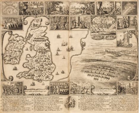
Rushworth (John). Historical Collections Private Passages of State. Of Weighty Matters in Law. Remarkable Proceedings in Five Parliaments. Beginning the Sixteenth Year of King James, Anno 1618. And ending the Fifth Year of King Charls, Anno 1629. Digested in Order of Time, 1st edition, London: Printed by Tho. Newcomb for George Thomason, 1659, linen-backed double-page engraved historical map frontispiece depicting scenes from the Civil War (slightly cropped to margins and repair to central fold), 2 engraved portrait plates (plate of James I torn to lower outer blank corner), with two-eaf dedication to Richard Lord Protector at front (sometimes lacking) and advert leaf at rear, leaf 4N1 torn to fore-margin slightly affecting marginal note to p. 654, endpapers renewed retaining 18th-century armorial bookplate of Thomas Fountayne (1713-1739) with elephant crest, and late 19th/early 20th-century bookplate of Frederick J[ames] O[sbaldeston] Montagu, (1878-1957), contemporary calf, neatly rebacked in light brown morocco with gilt decoration to spine and red morocco title label, corners refurbished, folio, together with:Wilson (Arthur). The History of Great Britain, being The Life and Reign of King James the First relating to what passed from his first access to the Crown, till his Death, London: Richard Lownds, 1653, lacking portrait frontispiece, short worm trail to initial leaves, some light dust-soiling, top edge gilt, red morocco bookplate of W. A. Foyle, of Beeleigh Abbey to upper pastedown, 20th-century red half morocco gilt by Sangorski & Sutcliffe, lightly faded to spine, small folioQTY: (2)NOTE:Provenance: 1. Thomas Fountayne (bookplate); Frederick J. O. Montagu (bookplate); 2. W. A. Foyle, Beeleigh Abbey (bookplate).1. STC R2316; Lowndes vol. IV p.2153; Abbot 1023.2. ESTC R38664; Wing W2888; Gibson, 651b. With a different setting from the edition with 'Iames' and 'accesse' in title and 'dore' in imprint (see ESTC R200950; Gibson, 651a).Rushworth’s Historical Collections narrates a turbulent period: the years leading up to the English Civil War. Throughout his narrative, Rushworth shows a partiality towards the side of Parliament. His narrative also issues a warning of the potential chaos and destruction that these might lead to. The important folding map, untitled but attributed to Wenceslas Hollar (Baynton-Williams, New Worlds, 83), juxtaposes a map of the British Isles with a view of the Battle of Prague – thus comparing the Thirty Years’ War that was devastating Europe with the Civil War that was engulfing England, and providing a warning to the English of the consequences of civil disorder.
Lot 91
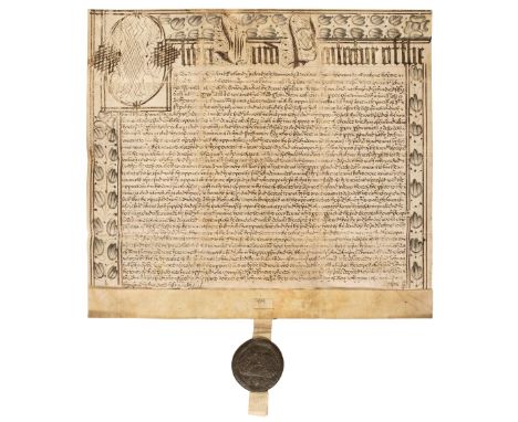
* Cromwell (Oliver, 1599-1658). Lord Protector of England. Great Seal of the Commonwealth, attached to a vellum document, Westminster, 24 May 1658, the document handwritten in brown ink and concerning a dispute between John Thornicroft and Jeffrey Hetherington over land and property in Charterhouse Lane in the parish of St Sepulchre's, to be tried before the Chief Justice, Oliver St John, calligraphic first line with large decorative initial 'O' and decorative initials 'L' and 'P' for the words 'Lord Protector', the borders decorated with pen and pencil floral motifs, some rubbing, spotting and uneven ink tones, skilful repair and pen work to small centre portion of upper border, 605 x 675 mm, a complete Great Seal of the Commonwealth appended (45 mm diameter), slightly rubbed, the whole folded into a bespoke plush-lined velvet document box to display the seal showing Parliament, burgundy morocco gilt bookplate of W. A. Foyle, Beeleigh Abbey to moire silk cover on inside of lid, 20th-century red straight-grained morocco lettered in gilt to upper cover and spine, oblong small folio (20 x 26 cm)QTY: (1)NOTE:Provenance: W. A. Foyle, Beeleigh Abbey (bookplate). A six-page typed transcription with silk spine tie is included in the box along with an old Maggs Bros catalogue description of the item, c. 1950's.Although both sides of the seal are somewhat rubbed some details of the impressions are still clearly visible. This is the second Great Seal of the Commonwealth (1651), the obverse showing a map of England, Wales and Ireland, the reverse the House of Commons in session.A rare and good survival.
Lot 270
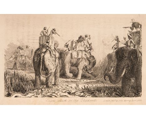
Mundy (Godfrey Charles). Pen and Pencil Sketches, being the Journal of a Tour in India, 2 volumes, 1st edition, London: John Murray, 1832, engraved frontispieces, 16 engraved plates, folding map (repaired), wood-engraved illustrations, bound without half-titles, some light offsetting and a few small stains, modern tan half calf, spines with burgundy morocco labels (slight fading to spine), 8vo QTY: (2)NOTE:Provenance: W. A. Foyle, Beeleigh Abbey.Czech, Asia p. 145: 'Travelling throughout India, the author hunted tiger near the Ganges and in the Dehra Dun. He spent time among the Mahrattas, observed wild elephants, and participated in antelope hunting with cheetahs and falcons. He also hunted lion between Pewur and Hansi, and though none were obtained, Mundy includes a discussion of the lion hunting exploits of Col. James Skinner and William Fraser. The plates of tiger hunting from elephant back are quite striking.'

Lot 236
Murray (Hugh). Historical Account of Discoveries and Travels in Asia, from the earliest ages to the present time, 3 volumes, Edinburgh: Archibald Constable Ltd, London: Longmans, Hurst and others, 1820, half-titles for volumes II-III, four folding engraved maps (a couple of small closed tears), some offsetting to titlers and spotting to maps, contemporary calf, burgundy and tan morocco labels to spines, volume I upper joint splitting, a little rubbed, 8vo, together with Historical Account of Discoveries and Travels in Africa, by the late John Leyden, M. D. Enlarged, and completed to the present time. With illustrations of its geography and natural history, as well as of the moral and social condition of its inhabitants, by Hugh Murray, 2 volumes, 1st edition, Edinburgh: Archibald Constable, London: Longman, Hurst and others, 1817, 6 engraved maps (including 3 folding, volume I frontispiece maps detached with splits and tears), reinforcements to a few folds, blindstamps to titles and map versos, some spotting, contemporary half calf, covers detached, some wear to spines, 8vo QTY: (5)NOTE:Provenance: W. A. Foyle, Beeleigh Abbey.
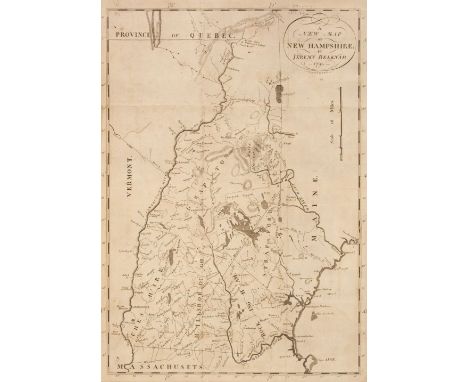
Lot 166
Belknap (Jeremy). The History of New-Hampshire, comprehending the events of one complete century from the discovery of the River Pascataqua, 3 volumes, 1st edition, Boston: for the author by Isaiah Thomas and Ebenezer T. Andrews & Belknap and Young, 1791-1792 (volume I, 2nd edition 1792, as often), folding engraved map to volume II, small worm holes and track to lower margin of volume II (just touching a few letters), inkstamps of the Library of the Board of Trade and H.M. Stationery Office to titles, bookplates of W. A. Foyle, Beeleigh House, modern brown calf, spines with burgundy and green labels and gilt decoration, edges a little rubbed, 8voQTY: (3)NOTE:Provenance: The Library of William Foyle, Part III, Christie's, 13 July 2000, lot 772 (part).Sabin 4434; Howes B323.The first extensive history of New Hampshire, and 'one of the most important eighteenth-century American histories' (Streeter). The Reverend Jeremy Bleknap (1744-1798), patriot and founder of the first American historical association, the Massachusetts Historical Society, provides a detailed history of the state, from its early frontier life and the wars against the Indians to the American Revolution, and in the third and final volume a miscellany of topographical, meteorolgical, botanical, zoological and agricultural information.

Lot 192
Juan (Don George & Don Antonio de Ulloa). A Voyage to South America: Describing at large the Spanish Cities, Towns, Provinces &c. on that Extensive Continent: undertaken by command of the King of Spain by Don George Juan, and Don Antonio de Ulloa, Captains of the Spanish Navy, Fellows of the Royal Society of London, Members of the Royal Academy at Paris &c., translated from the original Spanish; with notes and observations, and an account of the Brazils, by John Adams, Esq. of Waltham Abbey; who resided several years in those parts, 2 volumes, 5th edition, London: printed for John Stockdale & others, 1807, folding map frontispiece to volume I, 4 folding maps and plans, 2 folding plates, some offsetting from plates, contemporary tree calf, spines with red morocco labels and decorated in gilt, slightly rubbed at ends, 8voQTY: (2)NOTE:Provenance: W. A. Foyle, Beeleigh Abbey.Borba de Moraes p. 783; Cox II, p. 275; Sabin 36813.'Juan & Ulloa's Travels may be selected as the most entertaining and satisfactory work of its kind; they are the acknowledged source of much that has been published in other forms.' (Sabin).'This voyage arose out of the desire of the French Government (through the Academy of Sciences at Paris) to send certain members of the Academy of Sciences to measure a degree of longitude in the equinoctial countries of Peru... This request was not only accorded in the most courteous manner, but the King of Spain conceived the idea of sharing the honor of a scheme devoted to the advancement of knowledge, and sent two of the most scientific officers in the Spanish navy to accompany the expedition. This party carried on a series of operations of unexampled difficulty and encountered hardships and sufferings which demanded the strength of the strongest constitutions and the energy of minds stimulated by a love of science. Much information was collected and published, which has been reproduced in other works on South America.' (Hill).First published in English in Dublin in 1758, the original first edition in Spanish was published in Madrid in 1748.

Lot 382
Doughty (Charles M.) Travels in Arabia Deserta, 2 volumes, London: Jonathan Cape & The Medici Society, May 1924 reprint, half-titles, frontispiece to each, folding map contained in volume I rear pocket, folding plans and illustrations, light spotting to endpapers, prospectus and order form loosely inserted, morocco gilt bookplates of W. A. Foyle, Beeleigh Abbey, top edge gilt, light water stain to fore edges, contemporary tan morocco gilt, small light water stains at foot of spines and joints, 8vo QTY: (2)NOTE:Provenance: 'From the High Walpole Library, July/45', pencil note at front of volume I; W. A. Foyle, Beeleigh Abbey (bookplates).

Lot 309
Burton (Richard F). Abeokuta and the Camaroons Mountains. An Exploration, 2 volumes, 1st edition, London: Tinsley Brothers, 1863, folding map, photographic portrait frontispiece, 4 wood-engraved plates, armorial bookplates of Francis W Newdigate to front pastedowns, a few preliminary leaves spotted, original green pebbled cloth gilt, 8vo, contained in later blue cloth slipcaseQTY: (2)NOTE:Provenance: The Library of Franklin Brooke-Hitching, Part 1, Sotheby's, 27 March 2014, lot 216 (his pencilled initials to front free endpapers).Casada 25; Penzer, p.70.While British Consul at Fernando Po, Burton journeyed from Lagos to the Yoruba fortress of Abeokuta. On his return journey he explored the mountains from Ambas Bay to Pico Grande. During this he extensively documented flora and fauna, as well as his meetings with Yoruba royalty and their religious customs.
Lot 149
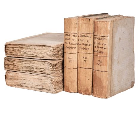
Gibbon (Edward). The History of the Decline and Fall of the Roman Empire, 6 volumes, 1st edition (except volume one, 2nd edition), London: printed for W Strahan; and T. Cadell, in the Strand, 1776, 1781 & 1788, half-title to each volume, engraved portrait frontispiece to second volume, folding engraved map to second volume (A Map of the Eastern Part of the Roman Empire), and single-page engraved map (Map of the Parts of Europe and Asia, adjacent to Constantinople), folding engraved map to third volume (A Map of the Western Part of the Roman Empire), each volume with contemporary ink signature of D. Gell to title or adjacent leaf, and late 18th century bookplate of Philip Gell Hopton to front pastedown and title verso of first volume, all volumes untrimmed (wide margins), a few leaves with minor marginal spotting or other marks (generally in clean condition), errata leaf at rear of second, third and sixth volumes, as called for, contemporary near-uniform plain boards (volumes one to three in grey boards, volume four to six in pale blue boards), spines titled in manuscript in brown ink, rubbed, first three volumes with repairs to head and foot of spines, large 4to QTY: (6)

Lot 327
Colomb (Captain Philip Howard). Slave-Catching in the Indian Ocean. A Record of Naval Experiences, 1st edition, London: Longmans, Green & Co., 1873, viii, [iv], 504 pp., half-title, 8 wood-engraved plates, folding lithographed map, hand-coloured in outline, original decorated russet cloth, all edges gilt, chalk-glazed yellow endpapers, rubbed, 8vo, contained in later blue cloth slipcaseQTY: (1)NOTE:Provenance: The Library of Franklin Brooke-Hitching, Part 1, Sotheby's, 27 March 2014, lot 280 (his pencilled initials to front free endpaper).A discussion of the East African slave trade, and of the general conditions under which the traffic proceeded or was suppressed; it includes chapters on Muscat and Oman, and the Persian Gulf, as well as Zanzibar and Madagascar. Colomb's visit to Bahrein coincided with disturbances brought about by the ousting (by the British) and subsequent return of Mohammed-bin-Kalifah, who was supported by Mubarak-al-Abdullah and Rashid-bin-Muselim, who were in turn backed by the Wahabis. The plan was to use dhows from Khor Hassan to ferry Rashid's forces to Bahrein, but rather than risk incurring the wrath of either the British on one side or the Wahabis on the other by becoming involved, the inhabitants of Khor Hassan sought refuge with Mohammed-bin-Thani. Colomb visited Wukra to meet Mohammed-bin-Thani and here describes his encounter and attempts to cure the sheikh's blindness (pp.154-160).
![[Campbell, John]. An Account of the Spanish Settlements in America. In Four Parts. I. An Account of the Discovery of America](https://cdn.globalauctionplatform.com/58f83210-d8be-44f6-bb81-b06d011764e4/c8367799-9b69-4fb1-b0ae-b07600e66b84/468x382.jpg)
Lot 140
[Campbell, John]. An Account of the Spanish Settlements in America. In Four Parts. I. An Account of the Discovery of America by the Celebrated Christopher Columbus... II. Their Settlements on the Continent of North America. III. Their Settlements in Peru, Chile, Paraguay, and Rio de la Plada. IV. Their Settlements in Terra Firma. Of the Different countries in South America still possessed by the Indians, etc. With a Description of the Canary Islands... to which is Annexed, a Succinct Account of the Climate, Produce, Trade, Manufacturers, etc., of Old Spain, 1st edition, Edinburgh: printed by A. Donaldson and J. Reid, for the Author and A. Donaldson, 1762, neat ownership inscription to head of title of 'Robert Southey, Keswick, Jany. 3, 1811', folding engraved map (A New General Map of America) with closed tear repaired, occasional light spotting, 20th century brown half morocco gilt, 8voQTY: (1)NOTE:Provenance: Robert Southey (1774-1843), poet and close friend of Coleridge and Wordsworth.Sabin 102; ESTC T45468. The final chapter comprises 'The accounts published by authority, of the siege and surrender of the Havannah, the chief town of the island of Cuba'.Robert Southey described the England of his day as "South American mad." As Spain's hold on its colonies progressively weakened during the late eighteenth and early nineteenth centuries, thousands of British scientists, soldiers, entrepreneurs and settlers rushed to take advantage of the enticing opportunities Spanish America offered. Britain's fascination with the region displayed itself in poems, plays, operas, political tracts, news reportage, travel narratives, and stock market quotations. Creole patriots such as Francisco de Miranda and Andrés Bello gathered in London to solicit aid for their revolutions while ministers debated tactics for liberating both the peoples and the untapped wealth of Spain's colonies.
Lot 338
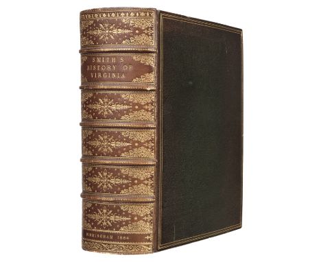
Arber (Edward, editor). Capt. John Smith, of Willoughby by Alford, Lincolnshire; President of Virginia, and Admiral of New England. Works. 1608-1631. Edited by Edward Arber, Fellow of King's College, London; F.S.A, Professor of English Language and Literature Sir Josiah Mason's College (The English Scholar's Library, 16), Birmingham: 1, Montague Road, 1884, cxxxvi, 984 pages, half-title, title printed in red and black, three folding plates including map of Virginia, autograph letter signed by Edward Arber to Dr. Rouse of Perse School, Cambridge, dated Saturday March 25th 1905 bound in at front (relating to the reprinting of John Smith's Accidence), top edge gilt, remainder untrimmed, inner gilt dentelles, maroon morocco gilt bookplate of W. A. Foyle to front pastedown, late 19th or early 20th century olive green crushed full morocco by Riviere, spine richly gilt, spine faded to brown, small thick 4to QTY: (1)NOTE:Limited Whatman Edition of 25 copies only, this copy numbered 16 and signed by Edward Arber.Fine copy. Much of the material in the thirteen books, pamphlets, and chronicles published under John Smith's name came from the writings of Richard Hakluyt, Samuel Purchas, Henry Mainwaring, or fellow officers of the Virginia Company, though Smith's hand as editor, compiler, and propagandist is evident throughout. Virtually all of these writings relate to the colonization of America, and includes Smith's A true relation of such occurrences and accidents of noate as hath hapned in Virginia (1608), A Map of Virginia: with a description of the countrey, the commodities, people, government and religion (1612), and The Generall Historie of Virginia (1624).

Lot 256
Cochrane (Charles Stuart). Journal of a Residence and Travels in Colombia, 2 volumes, 1st edition, London: Henry Colburn, 1825, half-title to volume 1 only (as called for), hand-coloured frontispieces to each (with tissue-guards), folding map of Colombia to volume 1, all edges gilt, contemporary red straight-grained morocco gilt, 8voQTY: (2)NOTE:Provenance: The Library of Franklin Brooke-Hitching, Part 1, Sotheby's, 27 March 2014, lot 270 (his pencilled initials to front blanks).Abbey Travel 718.

Lot 357
Churchill (Winston S.) Ian Hamilton's March, 1st edition, London: Longmans, Green and Co., 1900, half title, portrait frontispiece, folding map, 4 pp. and 32 pp. advertisements at end, small closed tear repair to blank foremargin of title and longer closed tear repair to Contents leaf, all edges gilt, later navy morocco gilt by Sangorski & Sutcliffe/Zaehnsdorf, upper cover with facsimile signature in gilt, spine with raised bands and lettered in gilt, 8vo QTY: (1)NOTE:Provenance: W. A. Foyle, Beeleigh Abbey.Woods A5.

Lot 84
Sparke (Michael). The Narrative History of King James, for the first fourteen years. In four Parts. I. The State of England at His Majesties entrance, and relation it had to other parts: the lascivious courses at court; with the Lord of Northampton's coming to honour: the division betwixt the Hollander and English, betwixt the Scot and English, betwixt the English and Irish: also the rising of Somerset..., II. The Proceedings touching the divorce betwixt the Lady Frances Howard and Robert Earl of Essex ... Also, the arraignment of Sir Jer. Elvis Lieutenant of the Tower, Sir Thomas Monson Knight, Anne Turner, ... touching the murthering and poysoning of Sir Thomas Overbury..., III. A Declaration of His Majesties revenue with assignations and defalcations upon the same, and of all monies brought into His Majesties coffers from time to time..., IV. The Commissions and Warrants for the Burning of two Hereticks, both holding part of the same our Ranters do, being old heresies, newly revived..., 1st edition, London: Printed for Michael Sparke, 1651, additional engraved allegorical title with preceding letterpress explanatory leaf ('The Emblematical Title explained'), folding engraved portrait of Robert Earl of Somerset and Lady Frances Howard, engraved portrait of Sir Thomas Overbury, EXTRA-ILLUSTRATED with 11 additional 17th-century portraits and a map of London, without blank V4 (as often), all edges gilt, burgundy morocco gilt bookplate of W. A. Foyle, Beeleigh Abbey to front pastedown, and printed description of this copy from an auction or bookseller's catalogue tipped onto front endpaper (dated 28/3/44), attractive early 20th-century gilt-decorated red full morocco, minimal marks to extremities, small 4toQTY: (1)NOTE:Provenance: W. A. Foyle, Beeleigh Abbey (bookplate).Wing S4818.Fine copy. The extra engraved illustrations are: portrait of King James by Vaughan, folding engraved map of Londinum by Johann Christopher Beer of 1690, based on the earlier map by Rutger Hermannides, published in Das Den-Geharnische Gross-Britannien in 1661 (Howgego, Printed Maps of London, 38), oval coat-of-arms of James I (in reverse), oval portrait of Prince Henry and his parents, oval portrait of Prince Henry on horseback, portrait of Sir William Wade, folding portrait of Sir Walter Raleigh by Simon Pass, portrait of Theodore Beza, portrait of Francis Bacon by Crispin de Pass, portrait of Jacobus VI, and double portrait of Frederick and Elizabeth of Bohemia.
Lot 289
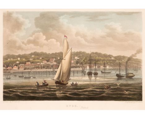
Calvert (Frederick). The Isle of Wight Illustrated, in a series of coloured views, engraved in aqua-tint by Mr. Percy Roberts, from the original drawings of the late Mr. F. Calvert, accompanied by a succinct historical, geographical and topographical description of the Island, 1st edition, 2nd issue, London: G. H. Davidson, 1846, half-title, tinted lithograph frontispiece, hand-coloured engraved map, 20 hand-coloured aquatint plates by Roberts after Calvert, some offsetting and light spotting, burgundy morocco gilt bookplate of W. A. Foyle, Beeleigh Abbey, all edge gilt, later green full morocco gilt, 4to, together with 2 others: The Beauties of the Isle of Wight: Containing an account of its watering places, a minute description of Ryde..., 3rd edition, circa 1828, and The Pleasure-Visitor's Companion in Surveying the Isle of Wight, by George Brannon, 5th edition, 1837 QTY: (3)NOTE:Provenance: The Library of William Foyle Part III, Christie's, 13 July 2000, part lot 867.Abbey Scenery 352 for Calvert, suggesting it is the second issue, with plate 4 titled 'Ryde. Plate I'.
Lot 175
Ireland (Samuel). A complete set of the Picturesque Views series, 6 works bound in 8 volumes, 1793-1802, comprising: Picturesque Views on the River Medway, from the Nore to the vicinity of its source in Sussex: with observations on the public buildings and other works of art in its neighbourhood, 1st edition, London: T. and J. Egerton, 1793, half-title, additional hand-coloured aquatint title, 28 hand-coloured aquatint plates, including frontispiece, single-page map, woodcut illustrations,Picturesque Views on the Upper, or Warwickshire Avon, from its source at Naseby to its junction with the Severn at Tewkesbury: with observations on the public buildings and other works of art in its vicinity, 1st edition, London: R. Faulder and T. Egerton, 1795, half-title,32 hand-coloured aquatint and etched plates, including frontispiece, single-page map, woodcut illustrations,A Picturesque Tour through Holland, Brabant, and part of France; made in the Autumn of 1789, 2 volumes, 2nd edition, London: printed for T. Egerton and others, 1796, half-title to volume I, additional engraved titles with hand-coloured vignettes, 48 hand-coloured aquatint and etched plates, woodcut illustrations, Picturesque Views on the River Wye, from its sources at Plinlimmon Hill, to its junction with the Severn below Chepstow: with observations on the oublic buildings, and other works of art in its vicinity, 1st edition, London: R. Faulder and T. Egerton, 1797, half-title,31 hand-coloured and etched plates, single-page map, woodcut illustrations, plate 27 'Interior of Tintern Abbey' close-trimmed to upper margin, errata slip tipped-in at end, Picturesque Views, with an historical account of the Inns of Court, in London and Westminster, 1st edition, London: C. Clarke for R. Faulder amd J. Egerton, 1800, 21 hand-coloured aquatint plates, woodcut illustrations, bound without half-title, Picturesque Views on the River Thames, from its source in Gloucestershire to the Nore; with observations on the public buildings and other works of art in its vicinity, 2 volumes 2nd edition, London: C. Clarke for T. Egerton, 1801-02, half-titles, additional hand-coloured aquatint titles, 52 hand-coloured aquatint plates, 2 maps, woodcut illustrations, occasional light offsetting, bookplates of George Seton Veitch, all edges gilt, finely bound in later crimson straight-grained morocco by Bayntun, Bath, additional stamps of bookseller Charles E. Lauriat, Boston, covers with geometric design in gilt, spines lettered with repeat geometric design in gilt to compartments, 8vo QTY: (8)NOTE:Provenance: George Seton Veitch (1835-1909); book collector; W. A. Foyle, Beeleigh Abbey.Abbey Scenery 428; 427; Abbey Travel 185; Abbey Scenery 544; 207; 430 (for the 1792 first edition) respectively.
Lot 53
Holland (Henry). Her?ologia Anglica, hoc est clarissimorum et doctissimorum aliquot anglorum qui floruerunt ab anno Cristi M.D. usq' ad presentem annum M. D. cxx vivae effigies Vitae et Elogia, duobus tomis, Authore H. H. Anglo Britanno: impensis Crispini Passæi Calcographus, et Jansonij Bibliopolæ Arnhemiensis, 2 parts in one, 1st edition, [Arnhem : printed by Jan Jansson at the expenses of Crispijn van de Passe and Jan Jansson for Henry Holland, London, 1620], )(10, A-V6, plus unnumbered single leaf of index at end (supplied from the reprint by Triphook), elaborate engraved title by Crispijn van de Passe (incorporating a small view of London and a miniature circular map of England, the leaf somewhat close-trimmed to fore-margin), two copper engraved plates (tomb of Elizabeth I and tomb of Prince Henry) and 65 fine full-page engraved portraits, engraved by Willem and Magdalena van de Passe, and 2 suppressed leaves, woodcut tail-pieces and initials, C4 with neat archival paper repair to fore-margin (not affecting text), T6 with minute repair to upper blank margin, and V1 with neat repair to upper portion of the leaf (without loss), one or two leaves with extreme upper outer blank corners carefully restored, marbled endpapers, bookplate of 'D. P.' and burgundy morocco gilt bookplate of W. A. Foyle, Beeleigh Abbey to front pastedown, and old bookseller's printed description tipped-in to front endpaper (bearing the catalogue number 787), attractive later 19th-century gilt-decorated full black crushed morocco, spine elaborately gilt, minimally rubbed to extremities, folioQTY: (1)NOTE:Provenance: D. P. (bookplate); W. A. Foyle, Beeleigh Abbey (bookplate).Hind Engraving, II, 145-162; Lowndes II, 1089; Graesse III, 322; ESTC S119103; STC 13582. 'The most trustworthy series of English portraits published up to that time' (Hind).A fine copy. The English bookseller and printer Henry Holland (1583–1650?) made his reputation with two fine books of historial portraits, the Bazili?logia, or Booke of Kings (1618), and the Her?ologia Anglica of 1620, which consists of portraits and biographies of Tudor and Jacobean monarchs, noblemen and courtiers including the explorers Frobisher, Hawkins and Drake, and Protestant reformers and martyrs, beginning with Henry VIII and ending with the publisher's namesake Thomas Holland, one of the translators of the King James Bible. Described by Roy Strong as a 'Protestant pantheon' (Henry Prince of Wales and England's Lost Renaissance, 2000, p. 21), Holland assures his readers that all the engraved images derive from a true likeness taken from an original portrait.
![[De la Combe de Vrigny, Jacques Philippe]. Travels through Denmark and some parts of Germany: by way of Journal in the Retinu](https://cdn.globalauctionplatform.com/58f83210-d8be-44f6-bb81-b06d011764e4/313067c2-e4f7-4a9c-a882-b07600e65acc/468x382.jpg)
Lot 112
[De la Combe de Vrigny, Jacques Philippe]. Travels through Denmark and some parts of Germany: by way of Journal in the Retinue of the English Envoy, in 1702. With extracts of several laws, relating to the absolute power of the King, religion, and civil government of the country: including the military and maritime state thereof: the whole illustrated with divers curious remarks... done into English from the French original, 1st edition in English, London: printed for J. Taylor, 1707, folding engraved map of the Isle of Huen by Willem Blaeu, large armorial bookplate of The Right Honourable the Lord Viscount Lymington (1718-1749), contemporary panelled calf, spine with tan label and richly gilt in compartments, a little rubbed, 8vo QTY: (1)NOTE:Provenance: The Right Honourable the Lord Viscount Lymington (1718-1749) (bookplate).ESTC T116589.
-
109198 item(s)/page