Poland. Muller (Johann), Poloniae Pars I - IV, Ulm, 1702, four uncoloured miniature maps, with letterpress in German below each map, each map approximately 70 x 80 mm, displayed in a four aperture mount, framed and glazed, together with De Vaugondy (Robert). Royaume de Pologne, Paris, 1762, engraved map with contemporary outline colouring, 245 x 290 mm, mounted, framed and glazed, with Moll (Herman). Poland subdivided into its several Palatinates &c. 1727 - 45, two engraved maps, one with contemporary outline colouring, the later edition uncoloured, each 200 x 260 mm, displayed in a double-aperture mount, framed and glazed, plus Morden (Robert). Poland, 1687 - 93, two engraved maps, one hand-coloured, the later edition uncoloured, with English text above and below the map, map size 105 x 130 mm, displayed in a double-aperture mount, framed and glazed, and Du Val (Robert). Pologne, 1662, hand-coloured engraved map, 140 x 175 mm, mounted, framed and glazed, with De La Feuille (Daniel). Le Royaume de Pologne avec ses Confins, circa 1706, two engraved maps, one hand-coloured, the later edition uncoloured, each 150 x 215 mm, displayed in a double-aperture mount, framed and glazed, plus Cluver (Philipp). Veteris et Novae regni Poloniae magniq Ducatus Lithuaniae cum suis Palatinatibus ac Confiniis Descriptio, 1711, two engraved maps, one hand-coloured, the later edition uncoloured, each 205 x 250 mm, displayed in a double-aperture mount, framed and glazed, and Jansson (Jan). Poloniae et Silesiae, Amsterdam, 1628 - 51, two hand-coloured engraved maps, each 150 x 200 mm, displayed in a double-aperture mount, framed and glazed, with De Fer (Nicolas). Les Estats de la Couronne de Pologne, 1705 - 18, two engraved maps, one hand-coloured, the later edition uncoloured, each 140 x 205 mm, displayed in a double-aperture mount, framed and glazed, plus Mallet Allain M.). Pologne, 1683 - 89, three engraved maps, two hand-coloured, each 155 x 120 mm, displayed in a triple-aperture mount, framed and glazed, together with another four framed maps of Poland, each with two states of the map within each frame, with examples by or after, Rossi, Moll, Lattre and Baeck, various sizes, good condition QTY: (14 )NOTE:The 14 frames contain 29 maps.


![Ireland. Speed (John), The Province of Connaugh with the City of Galwaye, Thomas Bassett & Richard Chiswell [1676], hand-](https://cdn.globalauctionplatform.com/7857d780-0570-41b1-a879-aebc011e27de/0d097033-e198-4e97-80c9-aecc011af316/468x382.jpg)


![Ogilby (John). The Road from St. Davids com. Penbroke to Holywell com. Flint [and] The Continuation of the Road from St. Davi](https://cdn.globalauctionplatform.com/7857d780-0570-41b1-a879-aebc011e27de/4844d313-e535-4f0f-bd09-aecc011b0667/468x382.jpg)


![Surrey. Smith (William), Surriae Comitatus continens in se oppida Mercatoria VII, P. Stent & J. Overton [1670 - 1707], un](https://cdn.globalauctionplatform.com/7857d780-0570-41b1-a879-aebc011e27de/a8792c3f-f0c5-4271-8abd-aecc011b13a4/468x382.jpg)


![Wales. Bickham (George), A New Map of South Wales West from London..., [and] A New Map of North Wales N. West from London, 17](https://cdn.globalauctionplatform.com/7857d780-0570-41b1-a879-aebc011e27de/6ca763ae-1e51-44f0-a8e9-aecc011b18e8/468x382.jpg)

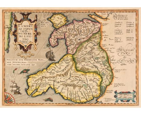
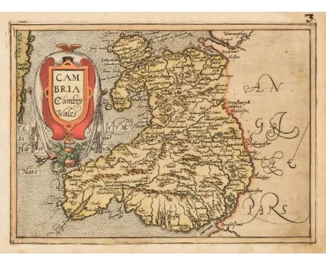
![Wales. Mercator (Gerard & Hondius Henricus), Cambria sive Wallia, [1607 - 21], uncoloured engraved map, slight overall to](https://cdn.globalauctionplatform.com/7857d780-0570-41b1-a879-aebc011e27de/fc84a332-8657-44de-9d19-aecc011b1b20/468x382.jpg)


![[Wren, Christopher]. Numismatum antiquorum sylloge populis Græcis, municipiis, & coloniis romanis cusorum, ex Cimeliarchi](https://cdn.globalauctionplatform.com/7857d780-0570-41b1-a879-aebc011e27de/8fc67a89-6ffa-4ff6-a613-aecc011b6ad8/468x382.jpg)


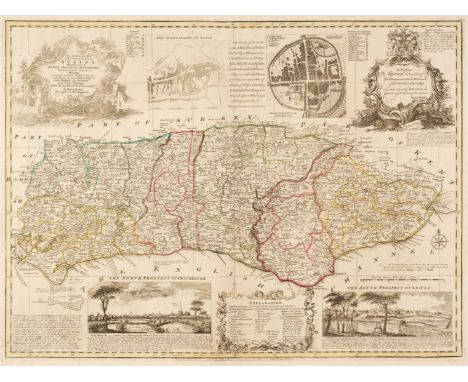
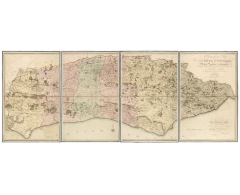
![[Worsley, Richard]. The History of the Isle of Wight, London: Printed by A. Hamilton, 1781, engraved vignette to title, fold](https://cdn.globalauctionplatform.com/7857d780-0570-41b1-a879-aebc011e27de/8a2eb643-1f4f-428d-b151-aecc011abbf7/468x382.jpg)