

Parkin (Charles). The Topography of Freebridge hundred and half, in the county of Norfolk, containing the history and antiquities of the borough of King's Lynn, Lynn: L. Davis, 1762, lacking engraved folding map, 2 engraved plates, folding table, inked-out early ownership initials to title (show-through to adjacent page), spotting, endpapers renewed, modern brown cloth gilt, folio, together with:Le Keux (John). Memorials of Cambridge, a series of views of the colleges & other public buildings of the university & town of Cambridge, 2 volumes, London: Tilt & Bogue, 1841-42, steel-engraved frontispieces & vignette titles, steel-engraved plates throughout, smaller illustrations to text, spotting, contemporary half calf gilt, red morocco labels, rubbed, 8vo, withTaylor (William). The Antiquities of King's Lynn, Norfolk, Lynn: J. Thew, 1844, 30 steel-engraved plates, lightly spotted, modern red cloth gilt, 4to, with a Description of the Cathedral Church of Ely (1807)QTY: (5)
We found 109198 price guide item(s) matching your search
There are 109198 lots that match your search criteria. Subscribe now to get instant access to the full price guide service.
Click here to subscribe- List
- Grid
-
109198 item(s)/page

Catrou (Francois). The General History of the Mogol Empire, from its foundation by Tamerlane, to the Late Emperor Orangzeb. Extracted from the Memoirs of M. Manouchi, a Venetian, and Chief Physician to Orangzeb for above forty years, 1st edition in English, London: printed for Jonah Bowyer, 1709, folding engraved map, advertisements at end, some browning and spotting throughout, contemporary annotations and Cornwell House ink stamp at front, near contemporary blindstamped calf, joints slightly cracked, 8vo QTY: (1)NOTE:ESTC T122619.
Plot (Robert). The Natural History of Oxford-Shire. Being an Essay towards the Natural History of England, 2nd edition, Oxford: Leon. Lichfield for Charles Brome, 1705, folding engraved map, 16 engraved plates, title and dedication leaves reinforced with tape at gutter, lacking front endpaper, light toning to map, a few small tears and stains, previous owner inscription of J. Francis Penyston, Cornwell House, Oxfordshire to front pastedown, later panelled calf, a little rubbed with repairs, folio, together with [Wood, Anthony]. Historia et Antiquitates Universitatis Oxoniensis, Oxford: Sheldonian Theatre, 1674, additional engraved title, title with vignette of the Sheldonian Theatre, folding engraved plan (with closed tears at foot), occasional water stains and small marginal tears, Cornwell House ink stamp, contemporary calf, rubbed with some stains and edge wear, folio, plus A Compleat History of Middlesex/Bedfordshire/Buckinghamshire/Hertfordshire bound in one volume, circa 1780, with four folding maps by Robert Morden, small 4to QTY: (3)
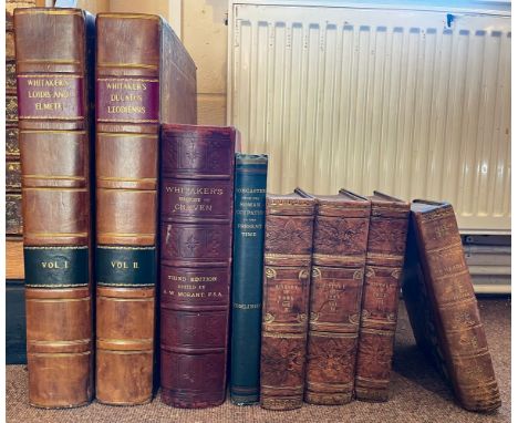
Whitaker (Thomas Dunham). Loidis and Elmete, or, an attempt to illustrate the districts described in those words by Bede, and supposed to embrace the lower portions of Aredale and Wharfdale, together with the entire vale of Calder, in the county of York, Leeds: Robinson, Son, and Holdsworth; Wakefield: John Hurst, 1816, large paper copy, half-title, engraved portrait frontispiece, title with engraved vignette on India paper, 50 engraved plates, two colour plates and 15 pedigrees (13 double-page, 2 folding), engraved illustrations, with appendix, together with Thoresby (Ralph & Whitaker, Thomas Dunham), Ducatus Leodiensis: or, the Topography of the Ancient and Populous Town and Parish of Leedes..., Leeds: Robinson, Son, and Holdsworth; Wakefield: John Hurst, 1816, large paper copy, half-title, engraved portrait frontispiece, title with engraved vignette on India paper (ink stamp to verso), 10 engraved plates and 11 double-page pedigrees, each volume with few blind stamps to lower margins mostly at front and rear, label to upper pastedown of the Scarborough Public Library Sir Meredith T. Whittaker Collection, uniform contemporary calf, gilt decorated border to boards, both volumes rebacked, contrasting title and volume number labels, light wear to board edges, folio,Allen (Thomas), A New and Complete History of the County of York..., 3 volumes, London: I.T. Hinton, 1828-31, engraved titles and numerous plates on India paper, occasional scattered spotting, near contemporary gilt and blind decorated calf, 4to,Bawdwen (William), A Translation of the Record called Domesday, so far as relates to the County of York, including also Amounderness, Lonsdale, and Furness, in Lancashire; and such parts of Westmorland and Cumberland... also the counties of Derby, Nottingham, Rutland, and Lincoln..., Doncaster: Printed by W. Sheardown, 1809, light toning, contemporary half calf, joints slightly cracked, 4to,Whitaker (Thomas Dunham), The History and Antiquities of the Deanery of Craven, in the county of York..., 3rd edition, edited by A.W. Morant, Leeds: Joseph Dodgson; London: Cassell Petter & Galpin, 1878, folding map, numerous plates, folding pedigrees, top edge gilt, near contemporary half sheep, 4to, and Tomlinson (John), Doncaster from the Roman occupation to the Present Time, Doncaster: John Tomlinson, 1887, few monochrome plates, original green cloth, extremities lightly rubbed, 4toQTY: (7)

Asia. Speed (John), Asia with the Islands adjoyning described, the atire of the people & Townes of Importance, all of them newly augmented, Thomas Bassett & Richard Chiswell, 1676, uncoloured engraved 'carte-a-figures' map with ten costumed figures to the vertical margins and eight oval vignettes of principal cities along the upper margin, slight marginal staining, 400 x 515 mm, English text on versoQTY: (1)

Australia. Ham (Thomas). A Map of Australia Felix compiled & carefully revised from the Colonial Government Surveys, Crown Lands Commissioners & Explorers Maps, Private Surveys &c. Melbourne, 1847, engraved map with contemporary outline colouring, sectionalised and laid on linen, inset map of southern Australia and Tasmania, table of reference, some staining and slight spotting, 465 x 735 mmQTY: (1)NOTE:A rare first edition of Thomas Ham's map. It shows various important boundaries including 'The Present Boundary' which was to become the boundary of the colony of Victoria when it separated from New South Wales in 1851, as well as the 'Proposed (& Original) Boundary' which skirts much further north along the Murrumbidgee River. Not in Tooley, The Mapping of Australia,

* British County Maps. Bowen (Emanuel), An Accurate Map of the County of Northampton Divided into its Hundreds..., J. Ryall, R. Sayer, T & J Bowles and Messrs. Bakewell & Parker [1762], engraved map with contemporary outline colouring, originally published in "The Royal English Atlas", large uncoloured cartouche and an inset vignette of Peterborough Cathedral, slight dust soiling, 500 x 410 mm, mounted, framed and glazed, together with Kitchin (Thomas). An Accurate Map of Warwickshire from the Best Surveys & Intelligences Divided into Hundreds..., J. Bowles & Son, Messrs. Bakewell & Parker, T. Bowles, J. Ryall & R. Sayer [1762], engraved map with contemporary outline colouring, originally published in "The Royal English Atlas", large uncoloured cartouche, some toning, 515 x 410 mm, mounted, framed and glazed, with Morden (Robert). Dorset Shire [and] Bark Shire [1695 or later], two hand-coloured engraved maps, each approximately 360 x 425 mm, framed and glazed, plus Smith (Charles). A New Map of the County of Bedford Divided into Hundreds, 1804, engraved map with contemporary wash colouring, slight spotting, 500 x 445 mm, mounted, framed and glazed, and Bowen (Emanuel). An Accurate Map of the County of Kent Divided into its Lathes and Subdivided into Hundreds..., J. Tinney, T & J Bowles and Robert Sayer, circa 1767, engraved map with contemporary outline colouring, sectionalised and laid on linen, inset map of "A Correct Draught of the Downs...,", large uncoloured cartouche, slight toning, a few small splits to the linen, old folds crudely strengthened and repaired on verso, 520 x 710 mmQTY: (6)

* British Isles. Blaeu (Johannes), Britannia prout divisa suit temporibus Anglo-Saxonum praesertim durante Illorum Heptarchia, Amsterdam, circa 1648, engraved map with contemporary hand colouring, vertical margins decorated with fourteen scenes of Saxon figures and events, very slight toning, 415 x 525 mm, mounted, framed and glazedQTY: (1)NOTE:R.W.Shirley. Early Printed Maps of the British Isles 1477 - 1650, number 549.
![British Isles. Homann (Johann Baptist). Magna Britannia complectens Angliae, Scotiae et Hyberniae..., 1729 [or later], engrav](https://cdn.globalauctionplatform.com/2a43871f-d280-4166-9f6c-af8800c0bef7/f3f3a1e3-c2b0-4d9f-9d46-af8900a95bd9/468x382.jpg)
British Isles. Homann (Johann Baptist). Magna Britannia complectens Angliae, Scotiae et Hyberniae..., 1729 [or later], engraved map with contemporary wash colouring, inset map of the Shetland and Orkney Islands, large uncoloured decorative cartouche, title repeated in English above the map, 495 x 575 mm, together with Magna Britannia complectens Angliae, Scotiae et Hiberniae Regna in suas Provincias et Comitatus divisa, Nuremberg, [1707], engraved map with contemporary wash colouring, large uncoloured decorative cartouche, slight dust soiling and water staining, one repaired closed tear affecting the printed image, 485 x 570 mm, with Regnorum Magnae Britanniae et Hiberniae Mappa Geographica..., Nuremberg, 1749, engraved map with contemporary wash colouring, inset map of the Shetland islands, small key plate to the lower left corner, large uncoloured decorative cartouche, title repeated in English above the map, slight worming but confined to the lower margin and not affecting the printed image, 485 x 555 mmQTY: (3)NOTE:R. W. Shirley. Printed Maps of the British Isles 1650 - 1750. Respectively - Homann 5 but this state is unrecorded. The plate was prepared by J. B. Homann's son, Johann Christoph, after his father's death in 1724, Homann 2 state 1 [and] Homann 6 state 1. This plate was prepared for Homann's heirs by Tobias Mayer, closely copying Homann's map of 1729.

British Isles. Jaillot (Alexis Hubert), Carte Generale des Royaumes D'Angleterre, Ecosse et Irlande..., Paris, 1669, engraved map with sparse contemporary outline colouring, inset map of the Shetland Islands, old folds partially strengthened on the verso, 395 x 515 mm, together with Valck (Gerard). Les Isles Britanniques qui contiennent les Royaumes d'Angleterre, Ecosse et Irlande..., Amsterdam, circa 1695, engraved map with contemporary outline colouring, inset map of the Orkney, Faroe and Shetland Islands, large allegorical cartouche and mileage scale, margins extended and with a skillfully repaired hole to lower right corner, 490 x 585 mm, with Valck (Gerard and Leonard). Magna Britannia aut Anglie, Scotia et Hibernia..., Amsterdam, circa 1705, engraved map with contemporary wash colouring, inset map of the Orkney and Shetland Islands, 495 x 600 mm, plus Schenk (Pieter). Novissima prae caeteris aliis accuratissima Regnorum Angliae, Scotiae, Hiberniae..., Leiden, 1706, engraved map with contemporary wash colouring, some oxidization to the old watercolour, uncoloured allegorical cartouche and mileage scale, slight staining, 580 x 490 mmQTY: (4)NOTE:R. W. Shirley. Printed Maps of the British Isles 1650 - 1750. Respectively - The first item is not in Shirley, then, Valck 1, Valck 2 (separately published) and Schenk 1 state 2.

British Isles. Jaillot (Alexis Hubert), Les Isles Britannique qui contiennent les Royaumes d'Angleterre Escosse, et Irlande..., Reiner & Josua Ottens, Amsterdam [1725], hand-coloured engraved map, inset map of the Shetland Islands, large allegorical cartouche and mileage scale, 505 x 610 mm, together with Nolin (Jean Baptiste). Les Isles Britanniques ou sont les Royaumes d'Angleterre, d'Ecosse et d'Irlande &c..., 1698, hand-coloured engraved map, inset map of the Faroe, Orkney and Shetland Islands, some creasing, long repaired closed tear affecting the image, central fold repaired and strengthened on verso, with Homann (Johann Christoph). Magna Britannia complectens Angliae, Scotiae et Hiberniae..., circa 1750, hand-coloured engraved map, inset map of the Orkney and Shetland Islands, large allegorical cartouche, some overall dust soiling, 495 x 575 mmQTY: (3)NOTE:R. W. Shirley. Printed Maps of the British Isles 1650 - 1750 Jaillot 4 state 3, Nolin 1 state 1 [and] Homann 5 state 4.
![British Isles. Ortelius (Abraham), Angliae, Scotiae et Hiberniae sive Britannicar: Insularum Descriptio, 1st edition [1570],](https://cdn.globalauctionplatform.com/2a43871f-d280-4166-9f6c-af8800c0bef7/367445c6-74d4-47d9-b897-af8900a95dc5/468x382.jpg)
British Isles. Ortelius (Abraham), Angliae, Scotiae et Hiberniae sive Britannicar: Insularum Descriptio, 1st edition [1570], uncoloured engraved map orientated to the east, large strapwork cartouche and panel of descriptive text, 345 x 495 mm, Latin text on versoQTY: (1)NOTE:Marcel Van den Broecke, Ortelius Atlas Maps, 16, Shirley, Early Printed Maps of the British Isles 1477 - 1650, number 86.
![* British Isles. Ortelius (Abraham), Britannicarum Insularum Typus [1595 or later], engraved map orientated to the west, cont](https://cdn.globalauctionplatform.com/2a43871f-d280-4166-9f6c-af8800c0bef7/6e9f5a1f-f3ad-43d5-972f-af8900a95e6f/468x382.jpg)
* British Isles. Ortelius (Abraham), Britannicarum Insularum Typus [1595 or later], engraved map orientated to the west, contemporary hand colouring, large strapwork cartouche, some oxidization to old watercolour, one small repaired hole in the lower strapwork margin, 365 x 505 mm, mounted, framed and glazedQTY: (1)NOTE:R. W. Shirley, Early Printed Maps of the British Isles, number 186. Marcel van den Broecke. Ortelius Atlas Maps number 192. Originally published in the Parergon.

British Isles. Petrini (Paolo), L'Inghilterra Divisa in sette Regni quarttro de Sassoni e'tre dell' Inglesi, et il Principato di Galles, ciascuno diviso ne lore Shire, overo contadi. La Scotia Regno diviso in due parti principali, di qua'e di la del Tay, overo ne due Regni, dei Pitti, e de Scoti. L'Irlanda Regno diviso in quattro Provincie e queste ne suoi Contadi..., Naples, circa 1705, uncoloured engraved map with a large decorative cartouche designed around a harp, 550 x 440 mmQTY: (1)NOTE:R. W. Shirley. Printed Maps of the British Isles 1650 - 1750. Petrini 1. Published in the 'Atlante Partenopeo'. The text within the cartouche states that it was published by "Paolo Petrini en Napoli alla strada di S. Biaggio delli Librari". While the map credits the work of Guillaume Sanson for the cartographic content; Shirley suggests that the source is more likely Cantelli-Rossi. Rare. World Cat lists only one institutional copy (The British Library).
British Isles. Pine (John), Sea Chart, originally published in 'The Tapestry Hangings of the House of Lords, Representing the Several Engagements between the English and Spanish Fleets, in the Ever Memorable Year MDLXXXVII...,' London: John Pine, 1739, two hand-coloured engraved sea charts on one sheet (as published), each map displayed within highly decorative allegorical borders, wide margins, slight staining to the margins, 390 x 615 mm, together with Hollar (Wenceslaus). A Mappe of Kent, Southsex, Surrey, Middlesex, Barke. and Southampton Shire & the Ile of Vight, part of Essex & Wiltshire etc. [and] The Mappe of Norfolke, Suffolke, Cambridge Shire, Bedford, Hartford, Buckingham, Oxford, Northampton, Warwick, Huntingdon and Lecester Shire & Rutland, part of Lincolne, Nottingham, Darbye, Glocester & Bark Shires & the County of Essex, circa 1644, two (only) engraved regional map sheets with contemporary outline colouring, originally published as the 'Quartermaster's Map', old folds crudely repaired on verso, some staining, 280 x 500 mm and 390 x 510 mm respectively, with The English Channel. A Correct Chart of the English and St. George's Channels with the Adjacent Coasts, circa 1800, unattributed hand-coloured engraved chart, old folds, upper margin trimmed to the neatline and extended with later paper, 180 x 385 mm and Mercator (Gerard). Eboracum, Lincolnia, Derbia, Staffordia, Notinghamia, Lecestria, Rutlandia et Norfolcia, circa 1627, hand-coloured engraved regional map of north-east England, slight creasing and some text show through, 360 x 420 mm, French text on versoQTY: (5)
![British Isles. Ptolemy (Claudius & Waldseemuller Martin), Tabula Prima Europae, Johannes Schott, Strasbourg [1513], uncol](https://cdn.globalauctionplatform.com/2a43871f-d280-4166-9f6c-af8800c0bef7/ba838cad-6949-4ce8-8e88-af8900a9605b/468x382.jpg)
British Isles. Ptolemy (Claudius & Waldseemuller Martin), Tabula Prima Europae, Johannes Schott, Strasbourg [1513], uncoloured woodcut map on a trapezoidal projection, repaired closed tears along the central fold, some staining to the central fold, 415 x 595 mmQTY: (1)NOTE:R. W. Shirley. Early Printed Maps of the British Isles 1477 - 1650, number 10. A scarce and early map of the British Isles, published in Schott's edition of Ptolemy's "Geographia". Scotland veers dramatically to the east. The map carries the fleurs-de-lys watermark, characteristic of this edition. The map was only re-issued once (in 1520) and this later edition lacks the title above the map.

* British Isles. Speed (John), The Kingdome of Great Britaine and Ireland, 1st edition John Sudbury & George Humble [1611], hand coloured engraved map, inset map of the Orkney Islands, inset views of London and Edinburgh, 385 x 515 mm, mounted, framed and double-glazed, English text on versoQTY: (1)NOTE:R. W. Shirley. Early Printed Maps of the British Isles 1477 - 1650, number 316.

British Isles. Waldseemuller (Martin), Tabu Hiberniae Sco, Laurent Fries, Strasbourg, circa 1522, uncoloured woodblock map with the title in a ribbon cartouche above the upper border, Latin text on verso set within elaborate Renaissance woodcut panels which may have been designed by Albrecht Dürer (Shirley), 320 x 410 mmQTY: (1)NOTE:R. W. Shirley. Early printed Maps of the British Isles, 1477 - 1650, number 16. This map is an example from Laurent Fries's edition of Ptolemy's Geography in which all the maps, including this one, were reduced versions of Waldseemüller's maps from 1513.
![* Carmarthenshire. Speed (John), Caermarden Both Shyre and Towne Described, 1st edition, [1611], hand-coloured engraved map,](https://cdn.globalauctionplatform.com/2a43871f-d280-4166-9f6c-af8800c0bef7/6e8c76a4-682a-4315-b47d-af8900a96263/468x382.jpg)
* Carmarthenshire. Speed (John), Caermarden Both Shyre and Towne Described, 1st edition, [1611], hand-coloured engraved map, inset town plan of Carmarthen, large strapwork cartouche, compass rose and mileage scale, 385 x 510 mm, framed and double-glazed, English text on verso, together with Caernarvon Both Shyre and Shire-towne with the ancient Citie Bangor described, 1st edition [1611], hand-coloured engraved map, inset town plans of Bangor and Caernarvon, large strapwork cartouche, and mileage scale, light overall toning, 385 x 510 mm, framed and double-glazed, English text on versoQTY: (2)
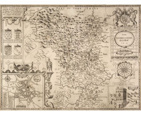
* Derbyshire. Speed (John), Anno Darbieshire described, published John Sudbury & George Humble, circa 1627, uncoloured engraved map, inset town plan of Derby and a vignette of St. Anne's Well at Buxton, large strapwork cartouche and compass rose, one small ink stain to the inset city plan, 385 x 510 mm, mounted, framed and double-glazed, English text on versoQTY: (1)

* England & Wales. Ortelius (Abraham & Saxton Christopher), Anglia Regnum si quod aliud in toto Oceano ditissimum et florentissimum, Jan Baptist Vrients, Antwerp [1603], hand-coloured map engraved by Pieter van den Keere, large decorative cartouche and strapwork mileage scale, additional strapwork cartouche paying tribute to Christopher Saxton and a large maritime vignette commemorating the attack of the Spanish Armada to lower-left, central fold appears to be professionally restored on verso, 385 x 485 mm, mounted, framed and glazedQTY: (1)NOTE:R. W. Shirley, Early Printed Maps of the British Isles 1477 - 1650, 258. Marcel Van den Broecke, Ortelius Atlas Maps, 20.
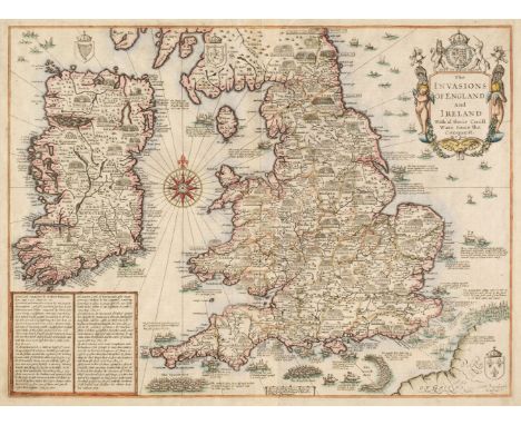
England, Ireland & Wales. Speed (John), The Invasions of England and Ireland with al their Civill Wars since the Conquest, Thomas Bassett & Richard Chiswell, [1676], hand-coloured map engraved by Cornelius Danckerts, decorative cartouche, compass rose and numerous rhumb lines, slight creasing, some marginal fraying and chipping, but not affecting the printed image, central fold crudely strengthened on verso, 380 x 510 mm, English text on versoQTY: (1)NOTE:R. W. Shirley. Early Printed Maps of the British Isles, 1477 - 1650, number 397.


WW1 period silk panel containing flags and insignia's for country's and regiments together with silks of prominent British military figures to include Lord Kitchener set on a red white and blue border, 57cm by 52cm, together with a Festival of Britain wooden box with a map of the South Bank Exhibition to the lid, pipe housed within a fitted case, and two books showing British regiments and medals (5)


Johann Baptist Homann (German, 1664-1724) and Johann Gabriel Dopelmayr (German, 1677-1750). "Sytema Mundi Tychonium Secundum celeberrimorum Astonomorum Tychonis de Brahe et Io. Baptistae Riccioli S.I. Hypotheses concinnatum," Nuremberg, 1725. This hand colored celestial map displays the solar system according to the work of astronomers Tycho Brahe and Giovanni Battista Riccioli.Provenance: Distinguished corporate collection, Minnesota.Height: 21 1/2 in x width: 25 1/4 in.

Group of two framed maps depicting Canada and the United States. One map depicting the East Coast of the United States as well as southeastern Canada. One map depicting Lake Superior and south-central Canada.Canada & East Coast; sight; height: 12 1/2 in x width: 16 in. Framed; height: 21 in x width: 24 1/4 in. Canada & Lake Superior; sight: height: 13 1/2 in x width: 16 1/4 in. Framed; height: 19 1/2 in x width: 22 1/4 in.


![[PRINTS] "View of the State House in Philadelphia", engraved by Bennett, 19.5 x 27 cms; & a defective map of "Discoveries](https://cdn.globalauctionplatform.com/11849aff-3fd4-4d74-98b7-af880105a156/c4a31f55-46ba-4f7b-a1be-af88010f4fde/468x382.jpg)
![[MAPS] "Carte von Tyrol", 18th c. sectioned map, linen-backed (damp stains); & q. similar.](https://cdn.globalauctionplatform.com/11849aff-3fd4-4d74-98b7-af880105a156/6148c944-3509-4adf-b8d0-af88010ea5e7/468x382.jpg)
![[MAP / AMERICANA] United States Geological Survey / Base Map, 1899, with ms. watercolour & ink updates / corrections by P](https://cdn.globalauctionplatform.com/11849aff-3fd4-4d74-98b7-af880105a156/895ea3fd-31d8-4170-9932-af88010f548c/468x382.jpg)
![[MAP / AMERICANA] U.S. Geological Survey / "Alaska Railroad Seward to Manuska Coal Field", folds, L.S.E. stamp, 114 x 99cms,](https://cdn.globalauctionplatform.com/11849aff-3fd4-4d74-98b7-af880105a156/58f3e416-d457-45e5-a9c5-af88010f5506/468x382.jpg)
![[MAPS] VIETNAM, Cambodia [etc.] 1967 National Geographic Mag., folding col. map; &, similar, "The Far East", 1952 (2).](https://cdn.globalauctionplatform.com/11849aff-3fd4-4d74-98b7-af880105a156/b205a07f-870b-4efa-9706-af88010f559e/468x382.jpg)
![[MAP] HANSON (Thomas) surveyor: "Plan of Birmingham Survey'd...1778", large map on 2 sheets joined, engr. by J. Roe, mounted](https://cdn.globalauctionplatform.com/11849aff-3fd4-4d74-98b7-af880105a156/2ab886db-094b-4eba-917f-af88010f69dd/468x382.jpg)
![[MAP] DOIDGE (W. & H.) Surveyors: Plan of the Ancient City of Canterbury..., h-col'd engr. map, 24.5 x 31 inches (central](https://cdn.globalauctionplatform.com/11849aff-3fd4-4d74-98b7-af880105a156/726b9a50-9101-4bc1-b33d-af88010f6a80/468x382.jpg)
-
109198 item(s)/page