We found 109198 price guide item(s) matching your search
There are 109198 lots that match your search criteria. Subscribe now to get instant access to the full price guide service.
Click here to subscribe- List
- Grid
-
109198 item(s)/page


![[MAPS] Morden, Robert (c.1650-1703), 'Somerset', engraved county map, hand-coloured in outline, 37cm x 43cm, framed and glaz](https://cdn.globalauctionplatform.com/c64e3e37-c0a3-46cc-8d31-a90a00d6b97d/d8f76809-798b-4d93-c4c0-a6a7ae6b9693/468x382.jpg)
![[MAPS] Morden, Robert (c.1650-1703), 'Cornwall', engraved county map, hand-coloured in outline, 35.5m x 41.5cm, framed and g](https://cdn.globalauctionplatform.com/c64e3e37-c0a3-46cc-8d31-a90a00d6b97d/16637f33-7004-4508-9d31-8dd6b565949a/468x382.jpg)


Lot 107
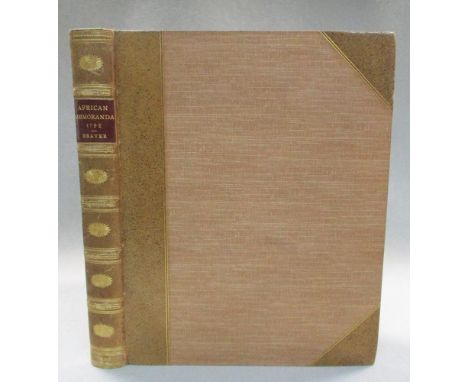
BEAVER (Captain Philip) African Memoranda: Relative to an Attempt to Establish a British Colony on the Island of Bulama, on the Western Coast of Africa, in the year 1792. London: for C and R Baldwin 1805, 4to, folding engraved map with some outline hand colour, two engraved plates, neat red 'Merton House' library stamp to title and overleaf, later plain binding with leather spine label

Lot 116
CHALKEY (Thomas) A Journal or Historical Account of the Life, Travels...., of Thomas Chalkey, 2nd edition London 1751, 8vo, age staining, half calf; COCHRANE (Capt. John D) Narrative of a Pedestrian Journey through Russia and Siberia Tartary from the Frontiers of China.., 3rd edition, 2 vols., 1825, 8vo, 2 coloured frontispieces, 2 folding maps and folding plan, rebacked calf; CRAVEN (Lady E) A Journey through the Crimea to Constantinople. Dublin 1789, 8vo, folding map and 2 folding plates, S8 torn with loss, tree calf; THOMPSON (Edward) Sailor's Letters written... during his Voyages and Travels in Europe, Asia, Africa and America, 2 vols., 1766, 12mo, calf (6)


![TAUNT (Henry W) A New Map of the River Thames. Oxford: Taunt & Co., [n.d.], 5th edition, 8vo, mounted albumen print frontispi](https://cdn.globalauctionplatform.com/70cd76c2-d42e-4a71-8a63-a904016edbbe/427436fc-d5a3-478a-9863-fcaf9dbd5591/468x382.jpg)
Lot 218
BEWICK (Thomas) A History of British Birds, Newcastle 1809, 8vo, rebacked calf; A General History of Quadrupeds, 2nd edition 1791, 8vo, finger soiled, blind stamped calf; [CROMWELL (T K)] Excursions through Essex, in 2 vols. 1818-19, 12mo, folding map and folding plan of Colchester, engraved plates, uncut, original marbled boards (4)

Lot 220
Buckinghamshire. LANGLEY (T) The History and Antiquities of the Hundred of Desborough, London: for R. Faulder 1797, 4to, folding map, 3 plates and two pedigrees, diced calf, Dogmersfield armorial bookplate; GIBBS (R) The Regicides of Buckinghamshire. 1879, 8vo, signed by the author; SHORTER (C) Highways and Byways of Buckinghamshire, 1923, large paper proof copy with letter and corrections; 7 others of Buckinghamshire interest; also three vols. art and architecture in morocco bindings (13)

Lot 222
Devon and Cornwall. Collection of 18th century and later vols. including: POLWHELE (Rev. R) The History of Cornwall - Supplement 1804, 4to, with 17 plates (some in sepia) and a large folding plate of Mounts Bay (small tear) by E. Harding, uncut, boards; RISDON (T) Survey of the County of Devon, and Continuation vol., 1714, 8vo, 2 plates, damaged bindings, lacking one board; CHAPPLE (W) A Review of Part of Risdon's Survey of Devon, 1785, 4to; BRAY (Mrs) Traditions... of Devonshire, 3 vols. 1838, 8vo; VANCOUVER (C) General View of the Agriculture of Devon, 1808, thick 8vo, folding map (loose), folding tables and plates, binding broken; CAREW (R) Survey of Cornwall,1811, 4to, calf, joints cracked; WESTCOTE (T) A View of Devonshire, 1845, thick 8vo, half morocco; SWETE (Rev. J) Travels in Georgian Devon, 4 vol. 1997, one of 1000 sets, slip case; MELLER (H) The Country Houses of Devon, 2 vols., 2015, slip case; others including history and topography etc., the earlier works in varying condition with some staining and age damage; sold not subject to return (c.60)
Lot 283
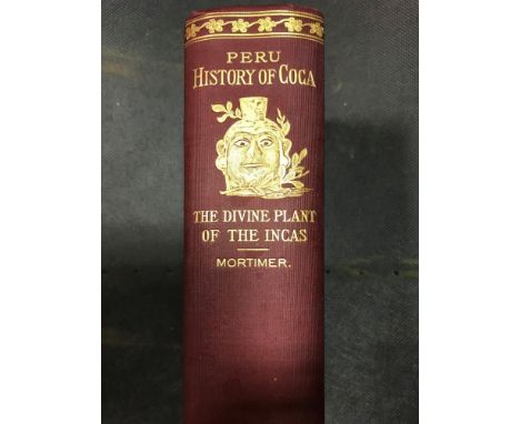
Literature, various, including: MORTIMER (W G) Peru, History of Coca, "The Divine Plant" of the Incas. New York 1901, illustrated, cloth gilt; FAIRBAIRN. Book of Crests, 2 vols, 4to, cloth gilt; HAYES (S) Practical Essay on Planting and the Management of Woods and Coppices, 1794, 8vo, calf; BECKE (Louis) Notes from my South Sea Log, London 1905, 8vo, portrait and map, original cloth; others - Jorrocks, modern fiction, etc

Lot 284
Literature and reference various, including: LILFORD (Lord) Birds of Northamptonshire and Neighbourhood, 2 vols., 1895, 8vo, folding map, photogravure plates, cloth; CELLARIUS (C) Geographia antiqua, London 1831, 8vo, 27 plates as required (mostly double page maps), worn calf; few others, coaching, by HISSEY, etc. Sold to benefit a charity

Lot 323
BEAVER (Captain Philip) African Memoranda: Relative to an Attempt to Establish a British Colony on the Island of Bulama, on the Western Coast of Africa, in the year 1792. London 1805, 4to, first edition, folding engraved map, two engraved plans, uncut, neat Ickworth library label to front pastedown, 20th century sprinkled half calf
![[MALCOLM (John)] Sketches of Persia, from the Journals of a Traveller in the East, 2 vols. in one, 1827, 8vo, 2pp. adverts at](https://cdn.globalauctionplatform.com/70cd76c2-d42e-4a71-8a63-a904016edbbe/459dab61-7f34-458c-a507-c61108d372e7/468x382.jpg)
Lot 324
[MALCOLM (John)] Sketches of Persia, from the Journals of a Traveller in the East, 2 vols. in one, 1827, 8vo, 2pp. adverts at end, half contemporary calf (rubbed); STUART (James) Three Years in North America. Edinburgh 1833, 8vo, in 2 vols., 3rd edition, author's inscription to Edward Lennox Boyd to both volumes with his armorial bookplate, folding map (slightly foxed), polished calf (rubbed) (3)

Lot 39
Michael Burghers, The Map of Oxfordshire, hand-coloured engraving for Dr Plot's Natural History of Oxfordshire, c.1680, 50.5 x 48cms; Richard Blome. A Mapp of the Isles of Wight, Jarsey, Garnsey, Sarke, Man, Orcades and Shetland, 17th century hand coloured engraved map on one sheet divided into sections, 29 x 39cm (2)


![John Speed, Herefordshire described, hand coloured engraved map, Bassett & Chiswell [1676] , English text verso, 39 x 51cm;](https://cdn.globalauctionplatform.com/70cd76c2-d42e-4a71-8a63-a904016edbbe/b6588b2d-0e1c-4f45-e247-b212d0c1ee47/468x382.jpg)


Lot 54
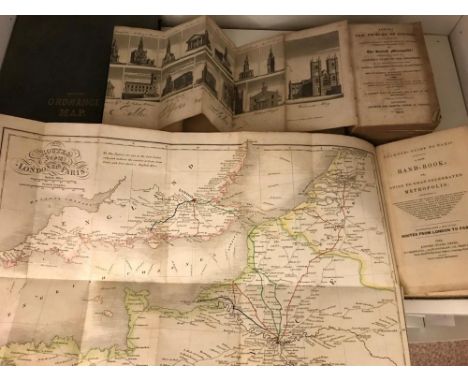
Collection of folding maps. LEIGH (S) Leigh's New Picture of London, 1818, 12mo, 12 folding plates and map, lacks London plan, damaged binding, age staining; PLUMMER. Guide to Paris, 1842, 12mo, folding map showing routes, original cloth; CRUCHLEY's ordnance survey map of Southern England, (from Hastings to the Isle of Wight, and Leigh (Essex), London to Wantage), hand coloured, late 19th century folding map, scale 2 miles to the inch; Devonshire by John Cary, 1811, folding hand coloured map, in wallet; and early 20th touring maps (quantity)

Lot 55
Willem Blaeu, Insulæ Americanæ in Oceano Septentrionali, cum teris adiacentibus. Hand coloured engraved map showing the West Indies with the East Coast of the Americas from Chesapeake Bay to the Orinoco, title cartouche with reptiles and putti, 46 x 56cm, somewhat toned, Amsterdam, [1635 or later]


Lot 91
OCKLEY (Simon) The Improvement of Human Reason, exhibited in the life of Hai Ebn Yokdhan. London 1708, 8vo, frontispiece slightly torn, 5 engravings, damaged calf; FRASER (James) The History of Nadir Shah, 2nd edition, London: for A. Millar 1742, 8vo, folding frontispiece and map; bound with 40pp. Catalogue of Manuscripts in the Persic, Arabic and Sanskerrit Languages, 1742, rubbed calf; PRIDEAUX (H) The True Nature of Imposture fully Display'd in the Life of Mahomet, 3rd edition 1698, 8vo, worn calf (3)

Lot 94
The Holy Bible, King James version, Appointed to be Read in Churches, Edinburgh 1633, small 8vo, 16.5 x 11cm, engraved title and Adam and Eve frontispiece (small losses), Genealogies at the start, double page map (chipped), NT title, names of owners (Wheeller and Steevens), later tree calf; another Bible, 1715, 8vo, 188 x 118mm, for John Basket and others, engraved title, NT dated 1712, slight cropping, later tree calf; Prayer Book and Psalter, 1736, 12mo, detached front board (3)

Lot 95
The Holy Bible, King James version, London: Robert Barker 1613, large 8vo, 222 x 165mm, title with decorative border, Genealogies at start, no map, black letter, double column, NT title slightly damaged at head with loss, Psalms incomplete at end, old staining, family names and graffitti, rebacked brass mounted boards lacking clasps; another Bible, King James version, London: John Field 1648, large 8vo, 23 x 17.5cm, engraved title, Prayer Book at start dated 1641, Psalms at end dated 1648, binding broken, Royal arms stamped to boards, lacking clasps and part of spine strip; The Holy Bible, King James version, Appointed to be Read in Churches, Oxford: John Baskett 1715, 4to, double column, worn binding; (3)

Lot 1295
Antiquarian Books - American Imprint, Medwin (Thomas), Journal of the Conversations of Lord Byron: Noted During a Residence with His Lordship at Pisa, in the Years 1821 and 1822, With Additions, Wilder & Campbell, New-York 1824, contemporary quarter-calf and marbled boards (loose), early 20th century Pictorial-Armorial bookplate: Ex Libris Wm Burnet Easton Jnr, signed Brad, 12mo; The Beauties of Washington Irving, Esq [...], Illustrated with Wood Cuts, Engraved by Thompson; From Drawings by George Cruikshank, Esq., fourth edition, Thomas Tegg and Son, London 1835, period buckram, 16mo; Westropp (Mrs. J.E.), Summer Experiences of Rome, Perugia, and Siena, in 1854; and Sketches of the Islands in the Bay of Naples, with Illustrations, William Skeffington, London 1856, gilt-tooled blue buckram, 12mo; Blyton (Enid), Brer Rabbit Book, Illustrated by Grace Lodge, first edition, Dean & Son Ltd, London 1963 (faults); Mercier (Anne) and Watt (Violet), The Red House by the Rockies: A Tale of Riel's Rebellion, pictorial boards; China, Lovett (Richard), James Gilmour and His Boys, With a Map and Many Illustrations, 1894, pictorial boards as issued, 12mo; other 19th century and later fiction, pictorial bindings; etc
-
109198 item(s)/page