We found 109198 price guide item(s) matching your search

Refine your search

Year

Filter by Price Range
  • List
  • Grid
  • 109198 item(s)
    /page

Lot 58

China.- Shanghai.- Blaeu (Johannes) Nanking sive Kiangnan, Imperii Sinarum Provincia Nona, regional map of centred on Shanghai, China, engraved map with original hand-colouring, on laid paper with large watermark of Atlas, platemark 405 x 485 mm (15 3/4 x 19 in), sheet 560 x 630 mm (19 7/8 x 24 in), rough edges with marginal nicks and tears, minor marginal damp-stains, some spotting and minor browning, unframed, [circa 1655]

Lot 7

Africa.- Danckerts (Justus) Totius Africae Accuratissima Tabula, map of Africa, engraving with hand-colouring on laid paper with original hand-colouring, sheet 504 x 590 mm (19 3/4 x 23 1/4 in), some marginal repairs with expertly restored losses, minor browning and surface dirt, unframed, [circa 1690]

Lot 122

Middle East.- Ellis (Tristram J.) On a Raft, and Through the Desert, 2 vol., first edition, half-titles, 2 etching frontispieces, 28 etchings, illustrations, one folding map, tissue-guards, advertisements at end, faint marginal finger-soiling, bookplate, original vellum, gilt, vol 2. with tear to spine head, a little rubbed and soiled, bumping to corners and extremities, 4to, 1881.

Lot 165

Polar.- Sverdrup (Otto) New Land: Four Years in the Arctic Regions, 2 vol., first English edition, translated by Ethel Harriet Hearn, half-titles, frontispieces, 60 plates, illustrations, 3 folding maps (2 in pocket at end vol. 2), one with small marginal loss not affecting image, scattered faint spotting, original decorative cloth, slight bumping to corners and extremities, 1904 § Peary (Robert E.) The North Pole, first edition, frontispiece, plates (3 photogravures), one folding map at end, title and introduction lacking upper corners (not affecting text), one or two ff. with small marginal loss (not affecting text), scattered spotting, later half-calf, fractional bumping to spine extremities, 1910 § Scott (Captain R. F.) Scott's Last Expedition, 2 vol., second edition, half-titles, frontispieces, plates, of which 6 photogravure, 18 colour, 2 panoramas and 3 double-page, 8 folding maps, one with short tear at gutter, scattered spotting, cracked hinges, original cloth, a little rubbed, bumping to corners and extremities, 1913; and others polar, 8vo (12).

Lot 113

Mexico.- Coronelli (Vincenzo Maria) Parte della Nuova Spagna, o del Mexico doue Sono le Provincie di Guadalaira Xalisco Mecoacan e Mexico..., map of western and central Mexico showing from Xiamora to Acapulco and includes Mexico City and Guadalajara, engraved map on laid paper with hand-colouring, platemark 450 x 605 mm (17 3/4 x 23 3/4 in), sheet 485 x 680 mm (19 1/8 x 26 3/4 in), unframed, [circa 1690]; together with four other maps of Mexico and Central America, including from Meyer's 1845 'Neueste Karte von Mexico' from Handatlas, Picquet's 'Carte Generale des Etats-Unis des Haut et Bas-Canada... seconde edition', L. Ewald's 1851 'Mexico und Texas', Brué's 'Carte Generale des Etats-Unis Mexicains et des Provinces-Unies de L'Amerique Centrale', engraved and lithographed, outline hand-colouring, various sizes between 360 x 450 mm (14 1/4 x 17 3/4 in) and 540 x 660 mm (21 1/4 x 26 in), minor nicks and tears, some handling creases, unframed, 19th century (5) 

Lot 137

Middle East.- Photographs relating to Persia, 19 vintage silver gelatin prints, most c.95 x 70 mm., manuscript notes to verso, fractional creasing to edges, [c.1930s] § Persian Gulf Command, illustrations, some full-page, previous owner's ink signature to final ff., original pictorial wrappers, slight rubbing to corners and extremities, [Tehran], [1945] § Hamzavi (A. H. K.) Henceforth Iran, plates, original decorative stiff card wrappers, a little rubbed, a little rubbed, [1936]; v.s.; together with a miscellaneous collection of pamphlets, maps, and advertisements for projects in Iraq, Kuwait, and elsewhere in the Arabian Peninsula, including a 1963 War Office and Air Ministry edition map mainly mid-20th century (Sm. Qty.).

Lot 211

World.- Ellis (Henry) Journal Of The Proceedings Of The Late Embassy To China, new edition, wood-engraved frontispiece map, Edward Moxon, 1840 bound with Hall (Capt. Basil) Narrative of a voyage to Java, China, and the great Loo-Choo Island : with accounts of Sir Murray Maxwell's attack on the Chinese batteries, and of an interview with Napoleon Buonaparte, at St. Helena, half-title with full-page wood-engraved map verso, small wood-engraved map in text, Edward Moxon, 1844 and 7 others, Travel, published by Moxon, including New York, together 9 works in 1 vol.,  some spotting or foxing and staining, contemporary half crushed morocco, gilt, spine in compartments richly so, some fading to upper cover, rubbed, thick 8vo

Lot 38

Belgium.- Sayer (Robert) Plan Routier de la Ville de Bruxelles, detailed city plan, engraving, 540 x 790 mm (21 1/4 x 31 in), dissected and mounted on linen, minor spotting and surface dirt, folding into near contemporary slipcase, for another map, the upper cover with label attached over a previous one, 8vo, 1783

Lot 61

Europe.- Lear (Edward) Journals of a Landscape Painter in Southern Calabria, &c., half-title, 20 lithographs, 2 maps, previous owner's pencil signature to title and front pastedown, scattered marginal spotting, cracked hinges, 1852; Journals of a Landscape Painter in Albania, &c., 20 tinted lithographs, one map, scattered marginal spotting, 1851; first editions, original cloth, rubbed, bumping to corners and extremities, rubbed and worn ; Journal of a Landscape Painter in Corsica, first edition, plates and illustrations, one map, scattered spotting, original cloth, a little rubbed, bumping to corners and extremities, 1870; [Abbey Travel 175 & 45], large 8vo.

Lot 27

Americas.- Hérisson (Eustache) Carte de l'Amerique Septentrionale, et Meridionale, avec les Nouvelles Decouvertes; pour Servir a l'Instruction de la Jeunesse, map of the Western Hemisphere with details of Cook's Voyages, engraving with hand-colouring, sheet 570 x 740 mm (22 1/2 x 29 in), slightly rough edges, minor nicks and tears, surface dirt, unframed, 1833; together with d'Anville's 'Partie Meridionale de la Louisiane, avec la Floride la Caroline et la Virginie', engraved map with hand-colouring, 475 x 580 mm (18 3/4 x 22 3/4 in), trimmed to borderline, re-margined and mounted on buff paper support, unframed, Santini and Remondini, 1784 (2)

Lot 127

Middle East.- Inter-Service Information Series (I.S.I.S.) Report on Trans-Saharan Routes, large folding map, detached and loosely inserted, illustrations, 2 have been removed by a previous owner, original cloth-backed boards, remnants of small paper label to upper cover, rubbed, bumping to corners and extremities, folio, October 1941. *** Unrecorded. Not on Library Hub or World Cat.  

Lot 71

Greece.- Holland (Henry) Travels in the Ionian Isles, Albania, Thessaly, Macedonia, &c., first edition, engraved map frontispiece, 12 engraved plates, previous owner's ink signatures to title, bookplate to title verso, spotting and staining, contemporary calf, rebacked, a little rubbed, 4to, 1815. *** Provenance: Bookplate of William Baldwin. 

Lot 161

Polar.- Heyerdahl (Thor), Soren Richter & H.J. Riiser-Larsen. Great Norwegian Expeditions, special edition, photographic plates and illustrations, very occasional light spotting, original morocco, gilt, t.e.g., very slightly rubbed, Oslo, [c.1955] § Kane (Elisha Kent) Arctic Explorations: The Second Grinnell Expedition in search of Sir John Franklin, 2 vol., first edition, engraved portrait frontispieces, additional engraved titles, 18 engraved plates, two folding maps, loose advertisement leaf at start of vol.1, bookplates, foxing on titles and plates, original blind-stamped cloth, spines sunned, corners and spine ends rubbed, Philadelphia, 1856 § Christie (E.W. Hunter) The Antarctic Problem, first edition, photographic illustrations, folding map at rear, loosely inserted telegram by the editor requesting a book review, original cloth, very slightly rubbed and soiled, 1951; and c.30 others, polar, v.s., (c.35)

Lot 74

Greece.- Vaudoncourt (Gen. Guillaume de) Memoirs of the Ionian Islands, considered in a Commercial, Political, and Military Point of View, first edition, engraved map frontispiece, large tear, scattered spotting, most at beginning and end, cracked hinges, near contemporary half-calf, rubbed and worn, backstrip beginning to split at joints but holding firm, 8vo, 1816.

Lot 11

Africa.- Lucas (Captain Thomas J.) Camp Life and Sport in South Africa, first edition, half-title, tinted lithograph frontispiece and 3 tinted lithographs, publisher's advertisements at end, small ink-stamp to title foot, original pictorial cloth, slight mottling to boards, bumping to corners and extremities, [Hosken p.128], 1878 § Balfour (Alice Blanche) Twelve Hundred Miles in a Waggon, first edition, half-title, frontispiece, illustrations (many full-page), folding colour map, advertisements at end, cracked hinges, original pictorial cloth, bumping to corners and extremities, 1895 § Napier (Lt.-Colonel E. Elers) Excursions in Southern Africa, 2 vol., frontispieces, one with previous owner's ink signature verso, 3 plates, illustrations, vol. 1 with advertisement ff. bound at beginning (previous owner's ink signature verso), scattered spotting, modern half-calf, 1850; [Hosken p.128; p.10; p.147]; and 2 others similar, 8vo (6).

Lot 28

Americas.- Sonnenstern (Maximilian von) Mapa de La Republica de Nicaragua Levantado por Orden del Gobierno, map of Nicaragua with several inset town plans and elevation profiles of volcanic peaks, lithograph with hand-colouring, 945 x 960 mm (37 1/8 x 37 3/4 in), dissected and mounted on linen, a few folds with splits, some light surface dirt and browning, folding into contemporary green cloth, upper cover gilt, 4to, Broise & Tiheffry, Paris, 1863

Lot 51

China.- Blaeu (Johannes) Xensi, Imperii Sinarum Provincia Undecima, regional map of Shaanxi province, China, engraved map with original hand-colouring, on laid paper with large watermark of Atlas, platemark 405 x 485 mm (15 3/4 x 19 in), sheet 560 x 630 mm (19 7/8 x 24 in), rough edges with marginal nicks and tears, minor marginal damp-stains, some spotting and minor browning, unframed, [circa 1655]

Lot 14

Africa.- Mounteney-Jephson (A. J.) Emin Pasha and the Rebellion at the Equator, first edition, frontispiece, plates and illustrations, 2 folding maps, previous owner's ink inscription to title, scattered spotting, cracked hinges, original pictorial cloth, rubbed, bumping to corners and spine extremities, 1890 § Anderson (Andrew A.) Twenty-Five Years in a Waggon, frontispiece, plates, folding map, publisher's advertisements at end,bookplate, cracked hinges, original cloth, slight bumping to corners and extremities, 1888; 8vo (2).

Lot 26

Americas.- Fer (Nicholas de) L'Amerique, Meridionale et Septentrionale Dressee Selon les Dernieres Relations et Suivant les Nouvelles Decouverte..., engraved map with hand-colouring, on laid paper with partial armorial watermark, platemark 225 x 332 mm (8 7/8 x 13 1/8 in), sheet 260 x 350 mm (10 1/4 x 13 3/4 in), trimmed to lower platemark, lower edge re-margined, some wormhole damage within the map, surface dirt and browning, unframed, [1717]

Lot 23

*** Please note the description of this lot has changed *** America.- Synge (Georgina M.) A Ride Through Wonderland, folding map frontispiece, short tear at gutter with old tape repair verso, 2 maps, light browning to last few ff., contemporary cloth, a little rubbed, slight fading to spine, slight bumping to corners and extremities, 8vo, 1892. *** An early work on Yellowstone Park, America's first National park.

Lot 25

Americas and Atlantic.- Lapie (Pierre) Amérique Septentrionale Et Méridionale Dediee et Présentée au Roi..., engraved map with outline hand-colouring, sheet 505 x 735 mm (19 3/4 x 29 in), dissected and mounted on linen, minor spotting, unframed, [circa 1820]; together with four other maps, including Paulin & Le Chevalier's 1860 map 'Mexique Antilles et Californie', Lapie's 'Carte des Antilles du Golfe du Méxique...', Herisson's 1833 'Carte des deux Amériques, avec leurs nouvelles divisions politiques...' and 'Carte D'Oceanie ou Australasie & Polynesie', engravings, various sizes between 450 x 610 mm (17 3/4 x 24 in) and 550 x 750 mm (21 3/4 x 29 1/2 in), some nicks and small losses, unframed, 19th century (5)

Lot 90

Italy.- Hoare (Sir Richard Colt) & John Smith. A Tour through the Island of Elba, first edition, half-title, 8 engraved plates, one engraved map, spotting, faint abrasion mark to title, small worming to early blank, new endpapers, contemporary half-calf, rebacked, rubbed, bumping to corners and extremities, 4to, 1814.

Lot 76

Holy Land.- Thuillier (Louis-François) Carte de la Palestine Ancienne et Moderne..., inset plan of Jerusalem and another two inset maps of the environs, map printed in colour, 970 x 740 mm (38 1/8 x 29 1/8 in), dissected and mounted on linen, some surface dirt and browning, folding into purple slipcase, upper cover gilt, 8vo, [c. 1900]; together with Victor Guérin's 'Carte de la Palestine', map printed in colours, 895 x 1200 mm (35 1/4 x 47 1/4 in), dissected and mounted on linen, folding into marbled slipcase, worn and scuffed, 4to, 1881 (2)

Lot 50

China.- Blaeu (Johannes) Fokien, Imperii Sinarum Provincia Undecima, regional map of Fujian province, China, engraved map with original hand-colouring, on laid paper with large watermark of Atlas, platemark 405 x 485 mm (15 3/4 x 19 in), sheet 555 x 630 mm (19 7/8 x 24 in), rough edges with marginal nicks and tears, minor marginal damp-stains, some spotting and minor browning, unframed, [circa 1655]

Lot 55

China.- Huc (M.) The Chinese Empire, 2 vol., second edition, spotting to first and last few ff., near contemporary calf, gilt arms to upper covers, a little rubbed, slight bumping to corners and spine extremities, 1855; Travels in Tartary, Thibet, and China. Illustrated, 2 vol., half-titles, frontispieces, additional vignette titles, one folding map, illustrations, scattered faint spotting, contemporary calf, a little rubbed, n.d. [c.1850]; 8vo (4).

Lot 202

Voyages.- Olearius (Adam) [The Voyages & Travels ... into the East-Indies ... containing a particular description of The great Mogul's Empire ...], 2 parts bound as 1 vol., lacking general title and additional engraved title, 3 engraved plates only, one engraved map only (trimmed, old repairs verso), remnants of 2 maps, spotting and staining, occasional rust-holes, previous owner's doodles and annotations, browned, modern front free endpaper, modern calf, rebacked and recornered, rubbed, folio, for Tho. Dring, and J. Starkey, 1662; sold not subject to return

Lot 264

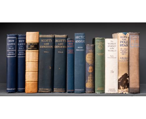
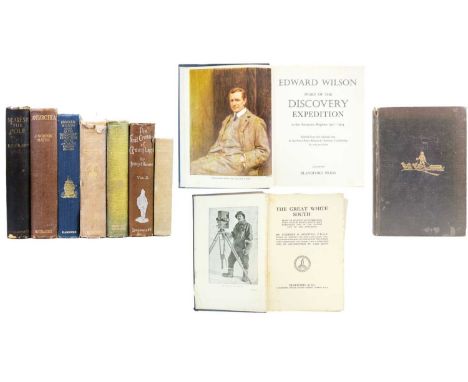
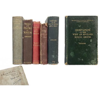
GORDON HAYES, J 'Antarctica. A Treatise on the Southern Continent,' First edition, original cloth with gilt lettering, sun faded and lightly rubbed, spotting to prelims and edge of text block, frontis, copious full plates, pp.448, vg, The Richards Press, London, 1928; 'The Conquest of the South Pole: Antarctic Exploration 1906-1931,' first edition, original cloth, sun bleached backstrip, rubbed and bumped, frontis, plates, spotting to edge of text block, good to vg, Thornton Butterworth, London, 1932; R. E. Peary. 'Nearest the Pole: A Narrative of the Polar Expedition of the Peary Arctic Club in the S. S. Roosevelt, 1905-1906,' first UK edition, original cloth, splitting to joint, rubbed and bumped, frontis debound, one plate loose, fold out map to rear, text block generally vg, Hutchinson & Co, London, 1907; Herbert G. Ponting. Fridtjof Nansen. 'The First Crossing of Greenland,' vol II only, original cloth with silver gilt decorations, chips to ends of backstrip with a small split along joint, some sporadic spotting throughout, engravings throughout, good to very good, Longmans, Green, and Co, London, 1890; 'The Great White South,' first edition, original cloth with chips to backstrip, loose frontis, spotting to edge of text block, copious plates, Duckworth & Co, London, 1921; With two other works including a first edition Charles Turley 'Nansen of Norway' and 'Diary of the Discovery Expedition to the Antarctic Regions 1901-1904' by The Blandford Press'. (7)

Lot 141

The Isles of Scilly. Twenty three works. John Fowles. 'Shipwreck,' first edition, photographic repodictions throughout by the Gibsons of Scilly, original cloth, unclipped dj, a very good copy, Jonathan Cape, London, 1974; the Rev. H. J. Whitefield. 'Scily snd its Legends,' a very nice copy in an embossed red cloth with gilt lettering to spine, later dj, ex libros label, some spotting to edge of text block, F. T. Vibert, Penzance, 1852; 'the Isles of Scilly. What to See and How to See it,' printed car wraps, later dj, fold out map as frontis, advertisements, vg, Gibson and Sons, Scilly Isles & Penzance, [c.1925]; James G. Owen. 'Faire Lyonesse. A Guide to the Isles of Scilly,' printed card wraps, staple bound, illustrations and advertisements, vg to fine, Coles & Owen, Bideford, 1897; J. G. Uren. 'Scilly and the Scillonians,' original green cloth with gilt tooling to front board, decorative endpapers, photographic plates, vg, The Western Morning News, Plymouth, 1907; With six other works including a very good copy of 'The Isles of Scilly' by Jessie Mothersol; and a good collection of booklets. (23)John Stengelhofen (1939-2020). Please see lot 1 for provenance.

Lot 118

St Ives Interest Ephemeral booklets about the town, including guidebooks MATTHEWS, John Hobson; A Guide To St Ives: It's Surroundings, Scenery, Curiosities, Antiquities, History and Traditions; James Wearne, Printer and Publisher, Saint Ives, 1884;BICKNELL, Ethel E; St. Ives Cornwall with its Surroundings. The Homelands Handbooks Vol. 78 of the Series; The Homelands Association / Frederick Warne & Co, London, 1910. A first edition and a third edition copy of this guide to this area of Cornwall. Some period advertisements. Not dated but believed to be from around 1910. The fold out map missing from the later edition, but other is loose with some tears and loss to margin, light foxing and otherwise good.PAYNTER, William; Old St Ives: The Reminisces of William Paynter; illustrative frontispiece of The Old Manor House, St Ives; two other lithograph illustrations of Seine Boat, St Ives and Tucking Pilchards in St Ives Bayz all three being reproduced by courtesy of Mr W. J. Cooper; James Lanham Ltd, St Ives, November 1927.PAGE, Hugh E; Walks Around St Ives, Cornwall; published by GWR, London, 1946;BADCOCK, W. 'Historical Sketch of St Just and District (With Illustrations) illustrations include Porthminster Hotel, Floods at Tregenna Place, St Ives, Gurnards Head and Lands End,' many advertisements of the time, detached cover with foxing, but text block mostly clear, F. Rodda, Penzance,1896.LAITY, R.P. 'St Ives in the 1800's,' illustration of The Schooner 'Sylph' of St Ives, Thos J. Williams, 1866 to title page and a further illustration of St Ives, 1813 to page 33, first edition, Wordens of Cornwall Ltd, Penzance, 1973; and four other guides to St Ives. John Stengelhofen (1939-2020). Please see lot 1 for provenance.

Lot 421

SPEED, John. 'Denbighshire' Engraved map, inset town plan of Montgomery, large strapwork cartouche, compass rose and mileage scale, English text to verso, centre fold, toning, partially hand coloured, framed and double glazed, 49 cm x 58.5cm, [17th century]; With one other and a framed Robert Morden of Cheshire. (3)

Lot 165

'Ding Dong Mine, Tavistock,' Hand drawn cross sectional of Dyers Shaft on tracing paper, scale 1 inch = 12ft, values in red (60% concentrate), lode width in green, approx 45.5cm x 74cm; 'Ding-Dong Mine Longitudinal Section & Assay Plan,' three copies, printed by Terrell Daris & Toll, showing cross sectional of Dyer's Shaft, thomas Shaft, Sprage's and No.2, with a transverse section of Dyers, approx 66cm x 312cm; Two copies of a fascimilie 18th century 'Plan of Ding Dong Mine', scale 1 inch=60feet, 74cm x 168cm; 'Ding-Dong Mine South Lode (Luscombe North Lode) Longitudial Section and Assay Plan,' three copies, printed by Terrell Davis & Toll, April 1944; Map of Tavistock Woodlands with a hand coloured key showing boundaries and mines, 60cm x 66.5cm. (10) From the estate of Ron Hooper, M.V.O., A.C.S.M., F.I.M.M.Born in St.Agnes, he graduated from Camborne School of Mines. After a short career mining in the Gold Coast of Ghana he joined the Camborne School of Mines, eventually becoming Senior Lecturer in Surveying. At the same time, he acted as an independent mining engineer and was appointed mineral agent for several Cornish estates including the Duchy of Cornwall, Tregothnan, and the Godolphin Estate (amongst others).

Lot 494

WHITAKER, Thomas Dunham. 'An History of the Original Parish of Whalley, And Honor of Clitheroe in the Counties of Lancaster and York,' Second Edition with Additions, with folding engraved map published 2nd November, 1801 by J. Hatchard, Piccadilly, unrepaired tear and some bleeding; folding map of The Abbey of Whalley, 1800, together with other plates and pedigrees on loose sheets; some foxing to pages, chipped and rubbed half calf marbled boards, J. Nichols et al, London, 1806.

Lot 430

OGILBY, John The Road From Exeter To Truroe A hand-coloured 17th Century engraved map, arriving to Truro via Dunsford, Chegford, Tavistock, Liskeard, Lostwithiel, Grampound and Truro, 35cm x 46cm, in a later Hogarth frame, 44.5cm x 55.5cm.

Lot 74

'Wood's Hand-Book to Cornwall, with Map and Illustrations,' Original embossed red cloth with a bright gilt tooled depiction of St Michael's Mount to front board, later uniform library dj, engraved title page, plates and vignette engravings, pp.172, 10.pp of advertisements to rear, small amount of spotting to vg fold out map pasted upside down to rear pastedown, some toning but generally a very good copy of this charming little work, W. Wood, Devonport, [circa 1865].John Stengelhofen (1939-2020). Please see lot 1 for provenance.

Lot 394

Mr Marshall 'The Rural Economy of the West of England: Including Devonshire; and Parts of Somersetshire, Dorsetshire, and Cornwall. together with Minutes in Practice,' Two volumes, full tree calf with gilt tooled shield to front boards The Society of Writers to the Signet, front boards are very loose, ink inscriptions to pastedown and ffep, spotting to fold out map, some off setting, contemporary ink inscription to title page, vg text block, G. Nocol et al, London, 1796. (2)

Lot 433

BOWEN, E An Accurate Map Of The County of Bedford, c.1750 Divided into its Hundreds, engraved cartouche, hand-coloured and engraved in outline, printed marginal notes, dedicated to the Most Noble John Russell, Duke of Bedford within a separate engraved cartouche, 73.5cm x 54cm, 77.5cm x 58cm including the later Hogarth frame.

Lot 331

BLAEU, Johannes (1596-1673) 'Cornubia sive Cornwallia.' Copper engraved map of Cornwall, contemporary hand colouring, Latin text to verso, centre fold, sporadic spotting, generally good to very good, mounted, glazed and framed, 62cm x 72cm, Amsterdam, [circa 1645].An early example from Blaeu's superb 'Theatrum Orbis Terrarum sive Atlas Novus'.

Lot 501

F. HAMILTON DAVEY Flora of Cornwall F. HAMILTON DAVEY. 'Flora of Cornwall Being an Account of the Flowering Plants and Ferns Found in the County of Cornwall Including The Scily Isles.' Original green cloth, gilt lettering to spine, faded boards, original folding map, F. Chegwidden, Penryn, 1909, vg; 'A Supplement to F. Hamilton Daveys Flora of Cornwall.' Original card boards, ex-libris Evelyn Northcote, Oscar Blackford, Truro, 1922; 'Journal of the Royal Institute of Cornwall, Vol XXI, Part 1-1922. Journal No. 69, Oscar Blackford, 1922; together in one slipcase.

Lot 177

St . Ives. 'Copy from Ordnance Maps to show Leases and accompany Report of October 8th 1907.....The Cornish Proprietary Mines Limited,' printed map with coloured areas showing names of ownership, tear to fore edge, some nibbles to edges, generally good to very good, 88cm x 108cm, [1907]; 'Section of Standard or Virgin Lode' cross sectional view, hand drawn on linen, showing Rosewall Hill and Ransom United Mines, Saint Ives Consol Mines, vg to fine, rolled, 25.5cm x 55cm; With three other related works including an exceedingly long (approx 482cm) preparatory sketch of a mine survey. (5) From the estate of Ron Hooper, M.V.O., A.C.S.M., F.I.M.M.Born in St.Agnes, he graduated from Camborne School of Mines. After a short career mining in the Gold Coast of Ghana he joined the Camborne School of Mines, eventually becoming Senior Lecturer in Surveying. At the same time, he acted as an independent mining engineer and was appointed mineral agent for several Cornish estates including the Duchy of Cornwall, Tregothnan, and the Godolphin Estate (amongst others).

Lot 7

HENDERSON, Charles. 'Mabe Church and Parish,' Original red thin card wraps, staple bound, five plates and map as called for, spotting throughout, pp.44, good, a scarce survivor, The King's Stone Pree, Shipston-On-Stour, [c.1930].John Stengelhofen (1939-2020). Please see lot 1 for provenance.

Lot 107

The Rev. John J. Daniell. 'A Geography of Cornwall,' Original cloth with publishers paper label to spine, later dj, tears and spotting to fold out engraved map, toning throughout, pp.226, Longman and Co, London, 1854; Ivor Thomas. 'Studies in Cornish Geography. Cornishmen and Environment and the Isthmus of Penwith,' vol I only, thing card wraps with some ink markings, vg, pp.92, Royal Cornwall Polytechnic Society Nichol Prize Competition, 1947 & 1948; Geoffrey Grigson. 'About Britain No.1 West Country,' original pictorial boards, unclipped dj, toning to edge of text block, illustrated throughout, The Festival of Britain Office, Collins, London, [1951]; With four other works. (7)John Stengelhofen (1939-2020). Please see lot 1 for provenance.

Lot 119

MATTHEWS, John Hobson 'A History of the Parishes of St Ives, Lelant, Towednack and Zennor,' Quarter leather with green cloth boards, frontispiece of St. Ives Church from the south-east, further illustrations include a map of the St. Ives District and multiple of St Ives Church amongst others; Elliot Stock, London, 1892.John Stengelhofen (1939-2020). Please see lot 1 for provenance.

Lot 96

(Cornwall, Zennor, Penzance, Camborne &c. &c.) Booklets and ephemera F. C. Hirst et al. 'Zennor illustrated by Bygones in the Zennor Museum,' card wraps, staple bound, illustrations throughout, pp.44, vg to fine, John W. Saundry, Penzance, n.d; J. B. Cornish. 'The Short Walks Around Penzance, With Map,' 8th edition, printed wraps, staple bound, text block de bound, fold out map to rear, pp.20, good, Beare & Son, Penzance, [1926]; 'Cornwall Health & Ideal Home Exhibition, City Hall, Truro, April 5th-9th 1932,' pictorial printed wraps, rust to staple bind, advertisements throughout, Oscar Blackford, Truro, [1932]. (Q)John Stengelhofen (1939-2020). Please see lot 1 for provenance.

Lot 149

'Plan of the Land of C. Wallis Popham Esq. In the Parish of Breage, 1860' Hand drawn map on linen, scale 4 chains to an inch, colour roads and borders, contents, folded, couple of stain spots, vg, approx 89cm x 67cm, [c.1860].A rare survivor evidently drawn on linen, due to paper tax.

Lot 67

The Great Western Railway. 'Through the Window. Paddington to Penzance (Cornish Riviera Route),' number one in the series, original blue cloth, later uniform library dj, gilt edge, plates and maps throughout, vg, The Great Western Railway, 1924; G. H. Anthony. 'The Hayle, West Cornwall and Helston Railways,' card wraps, later dj, vg, The Oakwood Library of Railway History, The Oakwood Press, 1968; R. J. Woodfin. 'The Centenary of the Cornwall Railway,' original orange cloth, later dj, fold out map for frontis, plates, vg, W. Jefferson & Son, ely, 1960; 'The Ocean Coast,' second edition, original cloth with card wrap bound in, plates, vg, Great Western Railway, London, 1927; S. P. B. Mais. 'The Cornish Riviera,' third edition, vg printed card wraps, later dj, plates and illustrations throughout, some spotting to margins otherwise a vg copy, Great Western Railway Company, London, 1934; E. T. MacDermot and C. R. Clinker. 'History of the Great Western Railway,' three volumes, 1833-1863, 1864-1922, 1923-1948, revised editions, original cloths, later dj's, vg, Ian Allen, 1964, 1964, 1967; With twenty one other works and a collection of booklets. (29+)John Stengelhofen (1939-2020). Please see lot 1 for provenance.

Lot 90

MILLET, G. B (editor) 'Official Guide to Penzance,' Original embossed cloth, rubbed and bumped, later uniform library dj, text block detaching from binding, advertisements, fold out map debound, fair to good, Beare & Son, Penzance, [1876]; 'Saundry's Penzance Almanack for 1929,' printed thin card wraps, copious advertisements, vg, john W. Saundry, Penzance, [1929]; With three other guides and two other works. (7)John Stengelhofen (1939-2020). Please see lot 1 for provenance.

Lot 38

Antiquities, architecture and history of Cornwall. A good collection of twelve works. Artthhur G. Langdon. 'Old Cornish Crosses,' original green cloth with some slight bumping, green tape applied to corners of boards, later uniform library dj, fold map for frontis, some sporadic spotting to prelims and margins throughout, illustrations throughout, good to vg, Joseph Pollard, Truro, 1896; J. T. Blight. 'Ancient Crosses and Other Antiquities in the East of Cornwall,' original cloth with gilt decorations, extremely toned and brittle to the touch throughout, illustrated throughout, in need of restoration, William Cornish, Penzance, 1872; 'Churches of West Cornwall; With Notes of the Antiquities of the District,' original cloth, text block debound, some spotting, John Henry and James Parker, Oxford and London, 1865; William Copeland Borlase. 'Naenia Cornubiae, a Descriptive Essay,' original red cloth rubbed and bumped, split inner hinge, ex libris label, Longmans, Green, and Dyer, London, 1872; M. and L. Quiller-Couch. 'Ancient and Holy Wells of Cornwall,' original blue cloth, later dj, light spotting to edge of text block, vg, Chas. J. Clark, London, 1894; With six other works including Henderson & Coats 'cornish Bridges', Seddings 'Norman Architecture in Cornwall' and Hencken. (12)John Stengelhofen (1939-2020). Please see lot 1 for provenance.

Lot 63

THOMAS, William (ed) 'International Mining Exhibition, London. 1923. Cornwall,' Printed card wraps, rust to staple bind, folded geological scetch map of Cornwall, several photographs of mines and locations, three leaves of advertisements to rear, pp.68, vg, scarce The Cornish Institute of Miining, Mechanical and Metallurgical Engineers, Printed by The Camborne Printing & Stationary Co, 1923.John Stengelhofen (1939-2020). Please see lot 1 for provenance.

Lot 197

'Part of the Manor of Blanchland in the Parish of Kenwyn,' 'the Lands of the Right Hon Lord Viscount Falmouth,' Map of the boundaries of the Manor of St Day, hand tracing of 1772 map with 1863 additions, on continuous paper, rolled, vg, approx 47cm x 263cm.Only known copy of the original map, From the estate of Ron Hooper, M.V.O., A.C.S.M., F.I.M.M.Born in St.Agnes, he graduated from Camborne School of Mines. After a short career mining in the Gold Coast of Ghana he joined the Camborne School of Mines, eventually becoming Senior Lecturer in Surveying. At the same time, he acted as an independent mining engineer and was appointed mineral agent for several Cornish estates including the Duchy of Cornwall, Tregothnan, and the Godolphin Estate (amongst others).

Lot 176

Mining and surveying. Five works. J. H. Collins. 'Observations on the West of England Mining Region,' first edition, original cloth with tears and rubbed, flat signed Herbert V. Thomas Dolcoath Mine to front free endpaper, fold out map, lithograph plates, printed for the Author by William Brendon & Son, Plymouth, 1912; J. B. Johnson. 'The Theory and Practice of Surveying,' sixteenth edition, original cloth, John Wiley & Sons, New York, 1907; A. K. Hamilton Jenkin. 'The Cornish Miner,' first edition, original cloth sun bleached, ink libri stamps to endpapers Camborne School of Mines, plates, George Allen & Unwin, London, 1927; Bennett H. Brough. 'A Treatise on Mine-Surveying,' ninth edition, original cloth, ink initials R.C.A.H, Charles Griffin & Company, London, 1902; With a rough copy of James D. Dana's 'Manual of Mineralogy & Petrography, 1895. (5) From the estate of Ron Hooper, M.V.O., A.C.S.M., F.I.M.M.Born in St.Agnes, he graduated from Camborne School of Mines. After a short career mining in the Gold Coast of Ghana he joined the Camborne School of Mines, eventually becoming Senior Lecturer in Surveying. At the same time, he acted as an independent mining engineer and was appointed mineral agent for several Cornish estates including the Duchy of Cornwall, Tregothnan, and the Godolphin Estate (amongst others).

Lot 128

(Mullion) HARVEY, E. G. 'Mullyon : Its History, Scenery and Antiquities' Original pictorial gilt cloth under a later dj, frontispiece of Cave at Porthpyg, Mullion Cove and illustration of Predannack Cross to title page, double-page map in good order and clean text block, missing illustration of Wreck of The Jonkheer, W. Lake, Truro, 1875.John Stengelhofen (1939-2020). Please see lot 1 for provenance.

Lot 159

Cornwall Railway interest. Carew-Pole Papers. Three vols of bound letters and indentures. Vol I-'Two Bills for Promoting the Railway in The County of Cornwall, 1844-1846,' bound in uniform blue cloth.Vol II-'Cornwall Railway Correspondence and Indentures for the Purchase of Land in the County of Cornwall, Antony Estate, Cornwall, 1855-1864,' indentures and MS relating to the railway 'Heads of Agreement for Land No 193, the Company have agreed to [the] procurement [of the] following lands in the parish of St Stephens.....together with the rights ...Carew...,' Includes detailed reports on Requisitions and Billing, with map, uniformly bound in blue cloth, 1855-1864.Vol III- 'Cornwall Railway/ G. W. R Correspondence, 1862-1902,' amended indentures, MS letters, and telegrams etc, all showing the working mechanisms of purchases of land by The G. W. R. from the Carew-Poles' of St Antony, uniformly bound in blue cloth, 1862-1902. (3)

Lot 435

SAXTON, Christopher & KIP, William Warwici, c.1610 'Comitatus a cor nauus olim in ha bitatus', hand-coloured, 30cm x 37cm; together with Richard Blome, 17th Century map of Hereford, ‘A generall Mapp of the County of Hereford with its Hundreds by Ric Blome by his Matys Especiall command’, hand-coloured, 31cm x 28cm.

Lot 179

'Plan of Great Flat Lode Workings' Survey by Tehidy Minerals Ltd, 1918. Printed on survey paper with handwritten colour ink additions, scale, 208.33 feet to one inch, two tears with loss to left edge, rolled, approx 100cm x 321cm; With an OS map of the area. (2) From the estate of Ron Hooper, M.V.O., A.C.S.M., F.I.M.M.Born in St.Agnes, he graduated from Camborne School of Mines. After a short career mining in the Gold Coast of Ghana he joined the Camborne School of Mines, eventually becoming Senior Lecturer in Surveying. At the same time, he acted as an independent mining engineer and was appointed mineral agent for several Cornish estates including the Duchy of Cornwall, Tregothnan, and the Godolphin Estate (amongst others).

Lot 504

P. Henrico Scherer (1628-1704) 'Atlas Marianus' 'Sive Praecipuae Totus Orbis Habitati Imagines Magnae Dei Matris Beneficiis ac Prodigiis Inclytae Succincta Historia Propositae. Et Mappis Geographicis Expressae,'Dedication, A-1, page 12 printed as 4, 116 as 119, pp.130, index, binders instructions showing where maps should be bound (frustratingly with graphite marks showing the price of each map, £9,700), LACKS ALL MAPS, full embossed pig with remnants of metal clasp, bevelled edge, front board debound with half title attached, some light spotting to an otherwise vg text block, blue ink edge, head and tailpieces, Typis Mariae Magdalenae Rauchin, Monachii, 1702.An extremely scarce work with WorldCat showing seven editions in sixteen libraries.

Lot 55

Mid nineteenth century reference books Ten works. Thomas Dugdale. 'Curiosities of Great Britain, England & Wales Delineated, historical, entertaining & commercial, alphabetically arranged, ...assisted by William Burnett; Leonard Townsend. 'An alphabetical Chronology of Remarkable Events, From the Earliest Authentic Period to the Present Time,' Both bound in Japanese vellum with embossed titles to spine, later uniform library dj, profuse in plates throughout, vg, Tallis and Co, London 1835 and 1840 (respectively); 'The British Almanac....1843,' staining to original cloth, later uniform library dj, vg, Charles Knight & Co, London, [1843]; With an 1846 almanack; Charles Howard. 'the Roads of England and Wales.....Particularly Adapted to the Use of Bicyclists and Tricyclists...,' staining to original blind stamped cloth, text block detaching, profuse in advertisements, vg large fold out map to rear, good to vg, Letts, Son & Co, London, 1883; with five other Victorian reference books in including 'Deacon's Court Guide and County Blue Book....Devonshire and Cornwall' and 'Paterson's Roads' 18th edition. (10)John Stengelhofen (1939-2020). Please see lot 1 for provenance.

Lot 481

FERN. Harold E. 'Cornish Chamber of Mines Year Book, 1918' Original dark blue cloth with some mould marks, spotting to edge of textblock, fold out map 'Showing Situation of Mines in Cornwall', three fold out charts, pp.69, Cornish Chamber of Mines, 1918; With the years 1920 and 1921. (3)

Lot 187

'Hearle Family Partition Map No.1,' Showing lands divided between F.F.Rodd Esq, J.C.L.Tremayne Esq, C.S.Richardson, Waterflow & Sons, London, early 20th century; 'Carnon Consolidated Limited. Wheal Jane Limited. Genreral Underground Plan,' sheets 1 to 13, showing transactional, cross sections, plans and surveys; 'Ttesavean Mines Lanner,' part tracing OS sheet LXIII.12 with boundaries of estates by J. E. F. Marshall; 'A Group of Tin Wolfram Mines. Klong Sra Paron Commune Distrit of Kanchanadith Surat Dhani'; With a large collection of other surveys, cross sectionals and plans &c. &c. including by United St. Day Mines. (Q) From the estate of Ron Hooper, M.V.O., A.C.S.M., F.I.M.M.Born in St.Agnes, he graduated from Camborne School of Mines. After a short career mining in the Gold Coast of Ghana he joined the Camborne School of Mines, eventually becoming Senior Lecturer in Surveying. At the same time, he acted as an independent mining engineer and was appointed mineral agent for several Cornish estates including the Duchy of Cornwall, Tregothnan, and the Godolphin Estate (amongst others).

Lot 167

Some with colour pencil additions from Hooper, in varying condition but mostly vg, all rolled. (Q)Including;0.5 1908 25 inch Scorrier and Wheal Rose, marked with lodes 0.5; 1974 Sheet 74 SW 74 St Day; 0.5 1963 Sheet SW 74 SW 6” St Day; 0.5 1890 Perranporth Rose, Gear Sands; 0.5 1908 25” North Country to Wheal Reevor marked with lodes; 0.5 1908 25” Redruth (S,W) to Carn Brea; Photocopy of 589 Overlaid with 1960s development; Photocopy 1908 25” 0.5 map Treleigh and Plain an Gwarry overlaid 1960s development; Photocopy part 0.5 25” map Shades bridge and Kestle Quarry; 0.5 1890 6” Perranporth; 0.5 1963 6” Redruth and St Day SW74SW; 0.5 1974 6” Redruth and Sat Day SW74SW with contours; 0.5 1908 25” Wheal Rose, Scorrier, Killifreth. Underground adits, including country adit marked in red; 0.5 1908 25” Redruth North (Plain An Gwarry, Treleigh) with laker housing superimposed; 1908 25” Redruth South Carn Brea Village Trewirgie, Victoria Park; 1908 25” Redruth North Country and Wheal Reevor, underground adits marked; 1908 25” Relubbus (left handed half); 0.5 1908 25” Goonlaze (Stithians parish); 0.5 1908 25” Brea Village, Condurrow, Treskillard, Carn A and then Piece; 0.5 1908 25” Tregonning Hill, Great Work Mine, Balwest, marked with a straight blue line; 0.5 1907 25” Navax Point, Hells Mouth, Hudder Downs, some fields coloured red; 0.5 1908 Part 0.5 LXXIV.8 Part Mounts Bay, The Greeb, Maen du Point; 0.5 1907 25” St Stephens Coombe Resugga; 0.5 1908 25” Pendarkes House, Treslothan, Ramsgate; 0.5 1908 25” Four Lanes; 0.5 1908 25” Mounts Bay, Methleigh, Tranno, Tremearne; 0.5 1908 25” Woon Gumpas Common with Penwith Boswens Common; 0.5 1907 25” Burnthouse, Laity moor, Roskrow (St Gluvias); 0.5 1936 25” Germae Tresowes Green; 0.5 1936 25” Kenneggy Downs and Kenneggy Sands; OS 50’ Copy SW 6539 SE 1967 Vivians Shaft Beacon;OS 25’ Copy SW 6439/59 Tregenna Lane, Camborne;OS 25’ Copy 6239/6339 Penponds;OS 50’ SW 6339 NE Camborne Rugby Ground;OS 50’ SW 6439 SW Barripper Road, Pendarvis Road;OS 50’ SW 6439 NW Tregurthen Road, Tregenna Lane;OS 50’ SW 6841 SE (photocopy) Carn Brea Mine, Carn Brea;OS 50’ SW 6841 SW (photocopy) Barncoose, Carn Brea;OS 50’ SW 6340 NW (photocopy) Weeth Road;OS 50’ SW 6340 NE (photocopy) Weeth Road;OS 50’ SW 6440 SE (photocopy) central Camborne Town;OS 50’ SW 6741 SW Carn Brea Leisure Centre;OS 50’ SW 6741 NW (photocopy) Flamingo, Taylors Shaft;OS 50’ SW 66 (photocopy) Pool School;OS 50’ SW 6641 NW (photocopy) A30 Junction Tolvadden;OS 50’ SW 6641 (photocopy) South Crofty, SWEB, Pool;OS 50’ SW 6641 (photocopy) Robinsons Shaft;OS 50’ SW 6640 Camborne Central;OS 50’ SW 6539 NE (photocopy) Pengegon;OS 50’ SW 6539 NW Stray Park;OS 50’ SW 6539 SE Beacon x 3;OS 50’ SW 6540 SW Wesley Street, Holmans;OS 50’ SW 6541 SE North Roskear;OS 50’ SW 6540 NE Roskear, Tuckingmill;OS 50’ SW 6440 SW College Street Camborne;OS 50’ SW 6540 SE Dolcoath, Pengegon;OS 50’ SW 6440 NW Reskadinnick Road;OS 50’ SW 6539 SW Trevu Road;OS 50’ SW 6640 NW Chapel Road, Tuckingmill;OS 50’ SW 6440 NW Enys Road;OS 50’ SW 6439 SW Mount Pleasant Road;OS 50’ SW 6439 NE Camborne Library;OS 50’ SW 6339 SE Penponds;OS 50’ SW 6340 NE Weeth Road West;OS 50’ SW 6340 SE Treswithian; OS 50’ SW 6540 NW North Roskear TA Centre;OS 25’ SW 6440–6540 Camborne;OS 50’ SW 6441–6741 Tuckingmill, Pool. (Q)From the estate of Ron Hooper, M.V.O., A.C.S.M., F.I.M.M.Born in St.Agnes, he graduated from Camborne School of Mines. After a short career mining in the Gold Coast of Ghana he joined the Camborne School of Mines, eventually becoming Senior Lecturer in Surveying. At the same time, he acted as an independent mining engineer and was appointed mineral agent for several Cornish estates including the Duchy of Cornwall, Tregothnan, and the Godolphin Estate (amongst others).

Lot 471

'Fishermans Map of Salmon Pools on the River Dee,' Hand drawn river map, 1959 Scale 1 inch to 1 mile, revised 1959, vignette watercolours, some water staining, signed I. Scott, framed and glazed, 15.5cm x 78cm.

Loading...Loading...
  • 109198 item(s)
    /page

Recently Viewed Lots