We found 108737 price guide item(s) matching your search
There are 108737 lots that match your search criteria. Subscribe now to get instant access to the full price guide service.
Click here to subscribe- List
- Grid
-
108737 item(s)/page


Lot 1661
A group of six various 9ct gold brooches to include a bar brooch set with three graduated diamonds, a wishbone example with Australia map shape, and a Victorian oval mourning brooch with lozenge mark, also a gold wedding band, a guitar shaped charm, and a long yellow metal open link guard chain with 9ct clip, combined approx 51g. CONDITION REPORT: Postage cost within UK would be £12 + VAT.

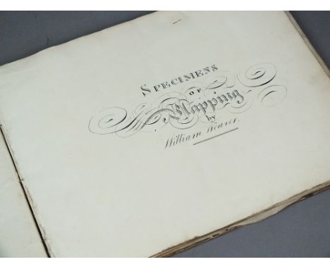
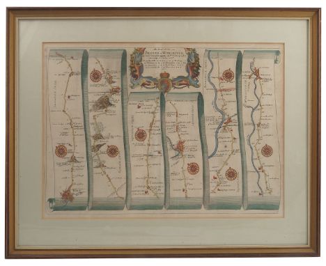
Lot 575
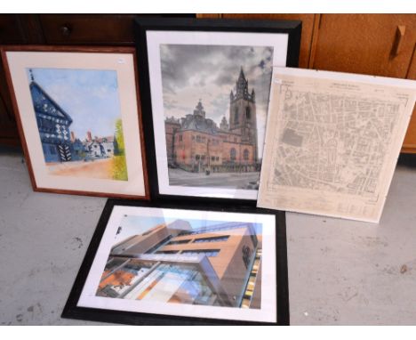
MANUSCRIPT. Specimens of Mapping and Calligraphy by William Weaver. Oblong 4to, early 19th century (paper is watermarked 1816). With 7 maps, some hand-coloured, including a map of the Manor of North Hill (Somerset) and a map of Chalk Farm and Hawthorn Upper Farm (near Chirk). With 5 grey wash drawings of castles etc and 13 pages of calligraphy. Worn half calf.


Lot 123
A mid 19th Century mahogany writing/draughtsman’s box,Campaign brass inset corners, typical slope profile when open, compartmented interior and three secret drawers revealed when panel released; with a MI steel micrometer; two compi; tweezers; early dividers; a map lens; a pair of early 19th Century spectacles; and two large wood draughtsman’s squares stamped LCC. (qty)
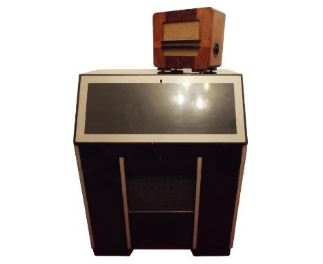
Lot 37
A scarce and unusual HMV bureau Autoradiogram type 582,circa 1937, The bureau with fitted interior with turntable, Nipper tonearm, auto-pillars, wireless with magic eye tuning and dial bearing television sound marker, leatherette writing surface to fall front, HMV folding paper folio opening to show map of world and stations, user manual in contemporarily-finished cabinet in black and grey; and an original finished HMV extension loudspeaker in oak and mahogany case. (2)Footnote: Reputed to have been installed in the main first floor meeting room at Broadcasting House, London and removed by previous owner in 1995.


Lot 849
RAF Cold War Presentation of an Australian Surface to Air Bloodhound Missile. This wood and chrome representation of a Bloodhound Missiles is mounted onto an outline map of Australia, with the presentation script “H.D. Constain Woomera Salisbury 1964-1965” Squadron Leader H.D. Costain OBE log books and archive is included in the sale. Woomera Rocket Range was an Anglo-Australia test site, during the period Squadron Leader Constain was present the RAF was introducing the MKII Bloodhound missile.


Lot 539
SIR THOMAS DYKE ACLAND, 10th Bart. (1787-1871)An album containing approximately 85 pencil and wash drawings, compiled on a trip to Switzerland in 1816, the half calf album with marble boards, the spine inscribed 'TDA Sketches 111', subjects include:Hospice on the Summit of the St. GothardTwo views of the Field of Battle at Laon, LucerneView of Schweitz from BrunnenAlltorff at the head of lake LucerneClonthalSource of the RhineLake of Wallenstatt from Wesern, St. GallBridge & Chapel of St. Giacomo, GrisonsCastle of Misocco, GrisonsLake of LuganoCurious waterfall below Avrolovarying sizes, 10 1/2 x 14 in (26.7 x 35.7cm); and smallerProvenance: Collection of Sir Richard Acland. Sotheby & Co. London. 24th June 1971. lot 27Sir Thomas Dyke Acland Bt. married Lydia Hoare in 1808. She was a keen musician and traveller. He was a talented amateur artist, and in the following years they are said to have gone on sketching trips in the Lake District, Ireland and Scotland.As a child Sir Thomas Acland received lessons from the artist Francis Nicholson. In 1808 the artist Francis Nicholson is recorded as having exhibited a 'View between Christiana and Konigsburg' from a sketch originally by Sir Thomas Acland.In the summer of 1814 after Napoleon's capture, Sir Thomas and Lady Acland went to the Congress of Vienna. In 1816 they embarked on a trip to Switzerland It seems probable that these drawings were produced by Sir Thomas Dyke Acland on the Swiss tour as a record of their travels. A map on the inside cover of the album details their route from Calais to Basle via Cambray, Rheims and Strasbourg


Lot 265
SMALL COLLECTION OF ROYAL COMMEMORATIVE CHINA AND POTTERY MUGS , BEAKERS ETC.. RELATING TO QUEEN VICTORIA, EDWARD VII AND GEORGE V includes; Shelley china BEAKER and MUG for 1911 Coronation, Victoria Jubilee POTTERY CUP AND SAUCER etc... 14 pieces TOGETHER WITH AN ENAMELLED METAL BEAKER 1902 CORONATION with bust portraits flanking a Map of the British Empire, very minor wear, 15 items in total


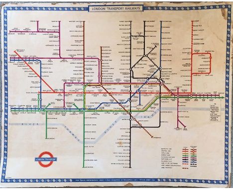
Lot 102
1949 London Underground quad-royal POSTER MAP designed by Harry Beck and mounted on hardboard, probably for official use. Shows the planned Northern Line extensions to Bushey Heath & Alexandra Palace and of the Bakerloo to Camberwell, none of which transpired. Scuffed edges with one or two small losses & some damp stains. The hardboard is bent in places & the backing paper on the reverse is coming away. [1] NB: this item measures 50" x 40" (101cm x 127cm).

Lot 110
London Underground linen-card POCKET MAP from the Stingemore-designed series of 1925-32. This is the last issue in 1932 with mustard cover and showing all the new lines completed with opening dates on the reverse. In very good condition and would be mint but for light vertical creasing near the r/h edge. [2]

Lot 119
c1909 Central London Railway POCKET MAP. The cover and reverse side are CLR's own, including their traditional map of their line superimposed on a street-map but the main map is the then standard London Electric Railways version which had been made available to non-Group companies as a gesture of support for a network approach. A well-used copy with wear to the cover and short fold-partings in places but still quite reasonable. [1]

Lot 128
1924 British Empire Exhibition at Wembley official fold-out PLAN & MAP designed by Kennedy North in a style similar to MacDonald Gill with an Underground map with calligraphed station names and elaborate, colourful illustrations plus a 1920s Metropolitan Railway MAP of 'Extension Lines into Metro-Land' with a map of London area lines on the reverse. Both in used condition with a little wear but good overall. [2]

Lot 131
1912 London Underground POCKET MAP "London's Guiding Star" printed by George Philip & Son Ltd and featuring the vertical UndergrounD logo. This issue marks stations with black-outlined white circles and shows the Met station as Hammersmith (Grove). The reverse shows a theatre plan, places of amusement etc. The 'Guiding Star' version of this map is quite uncommon. A little age-darkening but otherwise in very good condition. [1]


Lot 148
Pre-1914 London & North-Western Railway fold-out MAP OF THE BRITISH ISLES with inset London Tube Railways map. A high-quality linen-backed map of the national rail network (opens out to 34" x 42" - 87cm x 107cm) inside leathercloth covers with gilt lettering. Undated but first owner has written May 27/14 inside the cover and the Underground inset map shows the CLR from Shepherds Bush to Bank only (extended to Liverpool St in 1912). In very good condition. [1]
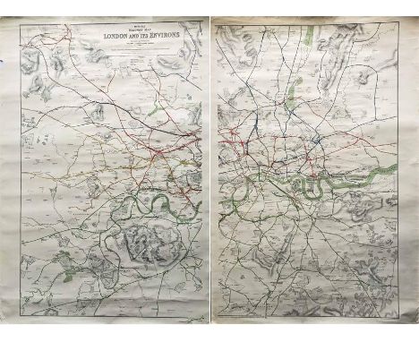
Lot 149
1927 Railway Clearing House 'Official Railway MAP of London & its Environs'. These highly detailed, coloured maps were produced to help the office staff of the RCH to apportion the revenues to the railway companies from the operation of services over each other's tracks. This London area poster map is produced in two sections, each measuring 28.5" x 42" (73cm x 107cm). In used condition with some short edge tears, a small edge loss and light creasing. [2 parts]
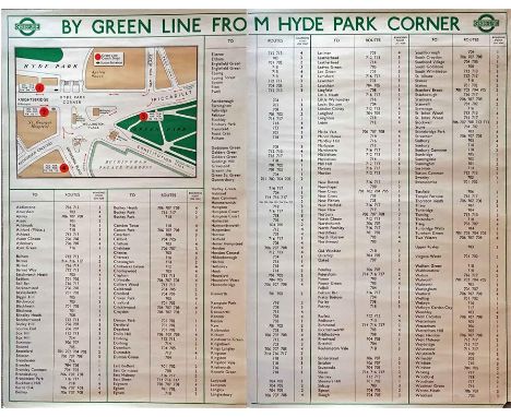
Lot 152
1947 London Transport POSTER 'By Green Line from Hyde Park Corner'. A pair poster (2 x double royal) issued in April 1947 for the start of the first summer of the fully re-instated coach network after WW2. Has the pre-war style 'bullseye' logo plus a map of Hyde Park Corner and an alphabetical list of towns/places served by Green Line from there. R/h poster is scuffed at the r/h edge & has a small loss at the bottom r/h corner, otherwise the pair is in good condition. [Pair]


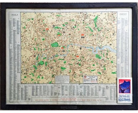
Lot 162
1939 London Transport POSTER MAP of Central Bus Routes with index of places served. Map is contained in an official glazed, wooden frame marked 'London Transport' (in contemporary style with over and underlining) at the lower edge. Measures 36" x 28" (92cm x 72cm) in total and is in good condition. Lot includes a copy of the May 1931 LCC Tramways MAP & TIMETABLE in good condition. [2]

Lot 170
1919 London Underground MAP OF THE ELECTRIC RAILWAYS OF LONDON 'What to See & How to See it' with print-code 209-500M-18-6-19. Has the black, open, bullseye circle on the cover and opens out in 8 panels to 13.7" x 10.9" (34 x 28cm). Some age-darkening and a bit fragile at the folds with a couple of short partings but overall a very reasonable copy. [1]

Lot 175
October 1911 London General Omnibus Company pocket MAP AND GUIDE TO OMNIBUS SERVICES. Featuring a B-type bus on the cover, this is the 8th edition of the London bus map, a series that ran from 1911 to 1993. This is a fine example, a little weak at some folds and corners but still good overall. [1]
-
108737 item(s)/page