We found 108737 price guide item(s) matching your search
There are 108737 lots that match your search criteria. Subscribe now to get instant access to the full price guide service.
Click here to subscribe- List
- Grid
-
108737 item(s)/page
![Diverse grafiek en tekeningen, 17e /m 20e eeuw [map]](https://cdn.globalauctionplatform.com/2eadee95-09f9-4483-83a7-af3801030a69/507c3eb4-fe39-4851-bdd2-af390140ef92/468x382.jpg)

![Cor Jaring (1936-2013) Vijf foto's allen met stempel verso [map]](https://cdn.globalauctionplatform.com/2eadee95-09f9-4483-83a7-af3801030a69/1a1e69b2-f89f-4449-9120-af39014b4994/468x382.jpg)
![Theo Wolvecamp (1925-1992) Zonder titel gouache, niet ingelijst, beschadigd, gesign. l.o., '57, 64 x 50 cm. [map]](https://cdn.globalauctionplatform.com/2eadee95-09f9-4483-83a7-af3801030a69/98333f6f-471b-4a2d-9856-af39014ac5b1/468x382.jpg)
![Klaas Gubbels (geb. 1934) Roze koffiekan litho, gesign. r.o., '77, 146/190, 75 x 57 cm. [map]](https://cdn.globalauctionplatform.com/2eadee95-09f9-4483-83a7-af3801030a69/18ab3aa6-b89d-4ff3-b68b-af39014b2551/468x382.jpg)
![Owen Morrel (geb. 1950) Acht diverse foto's deels gesigneerd ca. 24 x 16 cm. [map]](https://cdn.globalauctionplatform.com/2eadee95-09f9-4483-83a7-af3801030a69/61e822ed-d6a9-40f1-96f3-af39014b346a/468x382.jpg)
![Maria Elena Viera da Silva (1908-1992) 'L'arbre' litho, niet ingelijst, gesign., 54-190, 50 x 32 cm. [map]](https://cdn.globalauctionplatform.com/2eadee95-09f9-4483-83a7-af3801030a69/69e87020-19b1-4ffb-a841-af39014ad659/468x382.jpg)

![Erwin de Vries (1929-2018) Zonder titel aquarel, gesign. r.o., ''68, 47 x 36 cm. [map]](https://cdn.globalauctionplatform.com/2eadee95-09f9-4483-83a7-af3801030a69/86223fc8-f119-4ef5-bc13-af39014bc164/468x382.jpg)
![Maria Elena Viera da Silva (1908-1992) 'Carnaval' litho, niet ingelijst, gesign., 54-190, 50 x 32 cm. [map]](https://cdn.globalauctionplatform.com/2eadee95-09f9-4483-83a7-af3801030a69/91244639-447d-412c-abbb-af39014ad97c/468x382.jpg)
![Diverse moderne grafiek [map]](https://cdn.globalauctionplatform.com/2eadee95-09f9-4483-83a7-af3801030a69/83056521-69ac-41ea-8e1b-af39014b7888/468x382.jpg)
![Louise Bourgeois (1911-2010) Sheaves / Inner life tweemaal photolitho, gesign. in de druk, 31 x 21 cm. [map]](https://cdn.globalauctionplatform.com/2eadee95-09f9-4483-83a7-af3801030a69/f2404689-9045-41f5-a06e-af39014adea1/468x382.jpg)

![Kees van Bohemen (1928-1985) 'Clara' litho, niet ingelijst, gesign. r.o., 54-190, '78, 74 x 60 cm. [map]](https://cdn.globalauctionplatform.com/2eadee95-09f9-4483-83a7-af3801030a69/706f9dfe-615b-4810-a007-af39014b15d2/468x382.jpg)
![Karel Appel (1921-2006) Twee figuren litho, niet ingelijst, formaat volledige blad 38 x 55 cm. [map]](https://cdn.globalauctionplatform.com/2eadee95-09f9-4483-83a7-af3801030a69/630b6dd2-03e3-41b6-b4e6-af39014b998e/468x382.jpg)
![Klaas Gubbels (geb. 1934) Tafel ets en aquarel, gesign. r.o., '87, volledige blad 65 x 50 cm. [map]](https://cdn.globalauctionplatform.com/2eadee95-09f9-4483-83a7-af3801030a69/a4c320b9-5b1e-47ba-a7e4-af39014b1490/468x382.jpg)
![Antonio Saura (1930-1998) Zonder titel litho, gesign. r.o., '70, 27/200, 76 x 55 cm. [map]](https://cdn.globalauctionplatform.com/2eadee95-09f9-4483-83a7-af3801030a69/b61ddea8-6fe9-4a73-9881-af39014b088b/468x382.jpg)


![Erwin de Vries (1929-2018) Portret van een vrouw aquarel, gesign. r.o., '72, 47 x 35 cm. [map]](https://cdn.globalauctionplatform.com/2eadee95-09f9-4483-83a7-af3801030a69/7c547350-39df-46ef-a898-af39014bbf94/468x382.jpg)
![Karel Appel (1921-2006) Zonder titel litho, gesign. r.o., '69, 55 x 38 cm. [map]](https://cdn.globalauctionplatform.com/2eadee95-09f9-4483-83a7-af3801030a69/530a4b00-7022-4cf4-aa7c-af39014b09d1/468x382.jpg)


Lot 378
CARL LUDWIG BRANDT (1831-1905). Portrait of Jeremy Francis Gilmer, quarter-length, wearing a grey jacket, signed and dated 1889, oil on canvas, 32 x 25½in. Provenance: The Hutchison Family, Savannah; by descent.This work is believed to be a posthumous portrait of the sitter, possibly commissioned by a member of the Hutchison Family, with whom Gilmer had links. Carl Brandt is known to have painted another posthumous portrait- that one (dateable to 1896) depicted the philanthropist Mary Telfair. It was the bequest of her home to the public as an 'Academy of Arts and Sciences' that allowed the creation of the Telfair Museum of Art, Savannah. Carl Brandt was the first director of the Telfair Museum, serving in that capacity from 1883 until his death in 1905Jeremy F. Gilmer (1818-1883) was an American soldier, map maker and civil engineer, most noted for his service as the Chief Engineer of the Confederate States Army.During the American Civil War, as a major general , he oversaw the planning of the elaborate defences of the City of Atlanta , Georgia

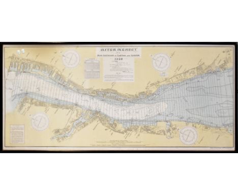
Lot 434
A Marine Surveyor and Water Bailiffs Drawing Office map depicting Liverpool Bay surveyed by the Marine Surveyors of the Mersey Docks and Harbour Board 1953, 100 x 107cm, framed and glazed, together with a maritime map of the River Mersey from Rock Lighthouse to Eastham and Garston 1954, 68 x 151cm, framed and glazed (2).

Lot 92
Percy J. Edwards - A Map of the River Thames from Rotherhithe to Putney, engraving with later hand-colouring, published by Edwards circa 1800, 28cm x 43.5cm, within a faux wood frame.Buyer’s Premium 29.4% (including VAT @ 20%) of the hammer price. Lots purchased online via the-saleroom.com will attract an additional premium of 6% (including VAT @ 20%) of the hammer price.

Lot 104
J. & C. Walker - 'A Newly Constructed and Improved Map of India, Compiled Chiefly from Surveys Executed by Order of the Honble. East India Company, London, Wm. H. Allen & Co.', engraving in 54 sections with hand-colouring, folding and backed onto linen, published by William Allen 1852, overall 165cm x 159.5cm, within cloth covered boards.This lot is subject to a Buyer’s Premium of 24.5% (including VAT @ 0%) of the hammer price. Purchased online via the-saleroom.com, this lot will attract an additional premium of 5% (including VAT @ 0%) of the hammer price.

Lot 97
William Kip, after John Norden - 'Sussexia sive Southsex olim pars Regnorum' (Map of the County of Sussex), 17th century engraving with later hand-colouring, 22cm x 38cm, within a gilt frame.Buyer’s Premium 29.4% (including VAT @ 20%) of the hammer price. Lots purchased online via the-saleroom.com will attract an additional premium of 6% (including VAT @ 20%) of the hammer price.
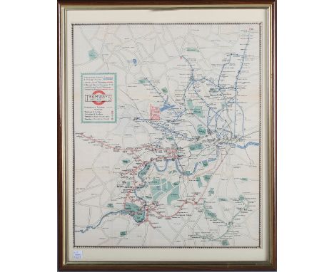
Lot 39
Eyre and Spottiswoode (publishers) - 'Tramways' (London Tramways Map), lithograph, printed and published circa 1923-1924, 44cm x 36.5cm, within a stained wood and gilt frame.Buyer’s Premium 29.4% (including VAT @ 20%) of the hammer price. Lots purchased online via the-saleroom.com will attract an additional premium of 6% (including VAT @ 20%) of the hammer price.
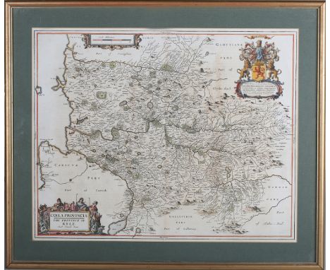
Lot 33
Johannes Blaeu, after Timothy Pont - 'Coila Provincia, the Province of Kyle' (Map of the Scottish District), 17th century copper engraving with later hand-colouring in outline, 46cm x 57.5cm, within a gilt frame, together with a similar map by the same hands, 'Sterlinensis Praefectura, Sterlin-Shyr' (Map of Stirlingshire).Buyer’s Premium 29.4% (including VAT @ 20%) of the hammer price. Lots purchased online via the-saleroom.com will attract an additional premium of 6% (including VAT @ 20%) of the hammer price.
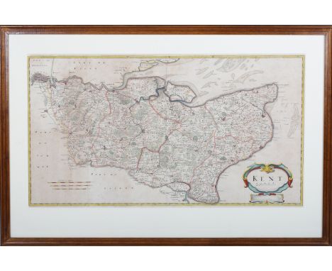
Lot 37
Robert Morden - 'Kent' (Map of the County), late 17th/early 18th century engraving with later hand-colouring on laid paper, 35cm x 63cm, together with seven other engraved maps, all within frames.Buyer’s Premium 29.4% (including VAT @ 20%) of the hammer price. Lots purchased online via the-saleroom.com will attract an additional premium of 6% (including VAT @ 20%) of the hammer price.
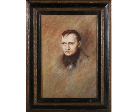
Lot 285
Follower of Paul Delaroche - Half Length Portrait of Napoleon Bonaparte, late 19th/early 20th century watercolour, 26cm x 17.5cm, within an ebonized and gilt frame, together with a mezzotint of the Duke of Wellington, a chromolithograph after Hillingford, 'Wellington at Waterloo', an engraved map, 'The Battle of Waterloo', and a pair of engravings, 'The Duke of Wellington', and 'Napoleon Bonaparte'.Buyer’s Premium 29.4% (including VAT @ 20%) of the hammer price. Lots purchased online via the-saleroom.com will attract an additional premium of 6% (including VAT @ 20%) of the hammer price.
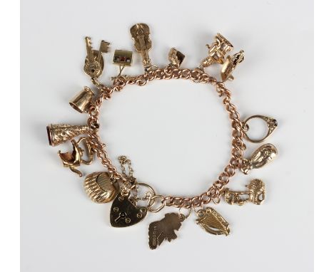
Lot 746
A 9ct gold curblink charm bracelet on a heart shaped padlock clasp, detailed '9ct', fitted with a variety of mostly 9ct gold charms, including a map of Ireland, a harp and a wheelbarrow, weight 26.5g.Buyer’s Premium 29.4% (including VAT @ 20%) of the hammer price. Lots purchased online via the-saleroom.com will attract an additional premium of 6% (including VAT @ 20%) of the hammer price.

Lot 35
Robert Morden - 'Oxfordshire' (Map of the County), 18th century copper engraving with hand-colouring on laid paper, 43.5cm x 36.5cm, together with another engraved map by the same hand, 'The County Palatine of Chester', and one other map, all within frames.Buyer’s Premium 29.4% (including VAT @ 20%) of the hammer price. Lots purchased online via the-saleroom.com will attract an additional premium of 6% (including VAT @ 20%) of the hammer price.
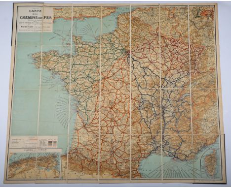
Lot 105
Gaillac-Monrocq (printers) - 'Carte des Chemins de Fer' (Map of French Railways), early 20th century lithograph in 28 sections, folding and backed onto linen, overall 106cm x 117cm, within cloth covered boards with gilt title.This lot is subject to a Buyer’s Premium of 24.5% (including VAT @ 0%) of the hammer price. Purchased online via the-saleroom.com, this lot will attract an additional premium of 5% (including VAT @ 0%) of the hammer price.

Lot 34
Richard William Seale - 'A Correct Chart of the English Channel…', 18th century engraving with hand-colouring on laid paper, 38cm x 47.5cm, within a gilt frame, together with a 19th century engraved map of Sussex.Buyer’s Premium 29.4% (including VAT @ 20%) of the hammer price. Lots purchased online via the-saleroom.com will attract an additional premium of 6% (including VAT @ 20%) of the hammer price.

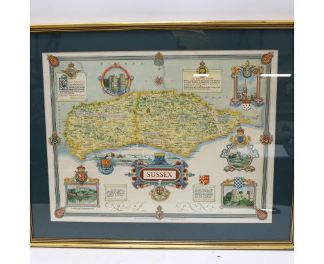
Lot 98
Jodicus Hondius, John Speede and John Norden - 'Sussex, described and divided' (Map of the County), early 17th century engraving with later colour, 39cm x 51cm, within a gilt frame.Buyer’s Premium 29.4% (including VAT @ 20%) of the hammer price. Lots purchased online via the-saleroom.com will attract an additional premium of 6% (including VAT @ 20%) of the hammer price.


Lot 308
A New Map of the North Part of Antient Africa, R. Spofforth sculp., Shewing the Chief People, Cities, Towns, Rivers, Mountains &c . . . Dedicated to his Highness William Duke of Gloucester, a hand-coloured engraved map, 37.5 x 49.5cm, mounted, framed and glazed, 56 x 65cm and a Robert Morden map of Norfolk,hand coloured and engraved mapoverall 40 x 61cm Provenance: The Collection of Anthony Thwaite.Condition ReportSome fading and creases. Not viewed out of frame. Both foxing and staining to the image and paper.


![A NEW NAVAL HISTORY OR, COMPLEAT VIEW OF THE BRITISH MARINE BY JOHN ENTICKfor R. Manby [and others], 1757, engraved frontispi](https://cdn.globalauctionplatform.com/d5a399e5-3749-460f-aa1b-af2400ae63ac/4fd24ab8-b098-416c-803c-af2400c33e60/468x382.jpg)
Lot 122
A NEW NAVAL HISTORY OR, COMPLEAT VIEW OF THE BRITISH MARINE BY JOHN ENTICKfor R. Manby [and others], 1757, engraved frontispiece, folding map (torn), 2 plates and 2 portraits (lower fore-corner of 3U2 torn away with loss, a little browning), contemporary vellum, later leather title-piece on spine -- 15½ x 9½ in. (39.5 x 24 cm.); and Vol II of Cook’s Second Voyage (towards the South Pole), London 1777, lacks plates.(2)Royal Naval Club & Royal Albert Yacht Club, Portsmouth

Lot 162
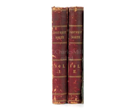
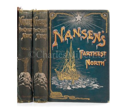
NARRATIVE OF A VOYAGE TO THE POLAR SEA DURING 1875-6, IN H.M. SHIPS ‘ALERT’ AND ‘DISCOVERY’ BY CAPT. SIR G.S. NARESSampson Low (and others) London, 1878, 2 vols. Large folding lithographed map mounted on cloth, another folding map and 5 plates being actual photographs mounted, numerous illustrations, modern cloth -- 8 x 5in. (20 x 13cm.); and the Arctic Voyages of Adolf Erik Nordenskiöld, 1858-1879, London, 1899(3)Royal Naval Club & Royal Albert Yacht Club, Portsmouth
![IN DARKEST AFRICA OR THE QUEST RESCUE AND RETREAT OF EMIN GOVERNOR OF EQUATORIA BY HENRY M. STANLEYSamson Low [and others], 1](https://cdn.globalauctionplatform.com/d5a399e5-3749-460f-aa1b-af2400ae63ac/9e8f5025-7a48-41ce-9718-af2a00db1417/468x382.jpg)
Lot 20
IN DARKEST AFRICA OR THE QUEST RESCUE AND RETREAT OF EMIN GOVERNOR OF EQUATORIA BY HENRY M. STANLEYSamson Low [and others], 1890, 2 vols, 2 large folding maps in colour (one torn) and numerous plates, a little foxing, original half hardgrain morocco, Royal Naval Club Portsmouth and H.M. Stanley stamped in gilt on front covers (rubbed) – 8¾ x 6½in. (22.5 x 16cm.); together with Discoveries in Egypt, Ethiopia and the Peninsula of Sinai in the Years 1842-1845 by Dr. Richard Lepsius edited by Kenneth R H Mackenzie, Richard Bentley, London, 1852, tinted lithographed frontispiece and folding engraved map (with a short tear, light worming slightly affects half title and plate), original blue embossed cloth (hinges and corners a little rubbed) – 9 x 5½in. (23 x 14 cm.)(3)Royal Naval Club & Royal Albert Yacht Club, Portsmouth
Lot 206
FRANCE AND TONGKING, A NARRATIVE OF THE CAMPAIGN OF 1889 AND THE OCCUPATION OF FURTHER INDIA BY JAMES GEORGE SCOTTT. Fisher Unwin, London, 1885, folding lithographed map and two folding plans, original pictorial cloth - 8¾ x 5¾in. (22 x 15cm.); together with Lives of the British Admirals by John Campbell for C.J. Babbington, 1812, 8 vols., engraved portrait frontispiece, browned and offset, contemporary half roan, uncut, rubbed – 9 x 5½in. (23 x 14cm.)(9)Royal Naval Club & Royal Albert Yacht Club, Portsmouth
-
108737 item(s)/page