We found 109198 price guide item(s) matching your search
There are 109198 lots that match your search criteria. Subscribe now to get instant access to the full price guide service.
Click here to subscribe- List
- Grid
-
109198 item(s)/page


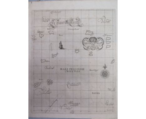
Lot 1471
Sir Robert Dudley (1573-1649) A map of the Indian Ocean - uncoloured - Size approx. 48cm x 38cm from Dell'Arcano del Mare circa 1661 - engraved by Antonio Lucini and published in Florence, Dudley was the first Englishman to publish a world sea atlas and the first with all the maps of Mercator's projection Condition report: Unmounted, some spotting, small tear top left, overall good


Lot 922
SECOND WORLD WAR - BATTLE OF BRITAIN AIRCRAFT RELICS collected by Essex school-boy John Fox Hutchins, each gathered at the time at local crash sites, many bearing hand-written paper labels of provenance in his hand including 'Incendiary bomb tail found on Mrs Brett's property, Upminster, during the Great Raid on London', 'Part of German plane brought down in Essex on 18th June near here (Lt Waltham)', and 'Piece of Spitfire which came down at Putney', all contained in a black tin box; together with a map marked with airfields; and a photograph of Hutchins aged 8 years.

Lot 913
SECOND WORLD WAR - A GERMAN EASTERN FRONT COMMEMORATIVE 'TRENCH ART' VODKA CUP AND TRAY SET the six cups made from 20mm cartridge cases, engraved with crossed horses' heads, the oval brass tray with an engraved map and inscribed 'Russland 1944', 'STARBYCHOFF', 'KROSSHIND', 'LASSNAJA', 'NOW SHIKI', 'PRIBOR', 'NOW TRASSNA', 'OLJANO', 'CHOTSCHINKI' and 'WASKOWILSCHI'.

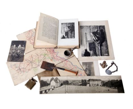
Lot 822
GREAT WAR - A UNIQUE ARCHIVE OF ILLUSTRATOR-SOLDIER RAPHAEL T. ROUSSEL 2ND LT./ CAPTAIN 3RD CONNAUGHT RANGERS including original black and white photographs, comprising group, unit and individual studies; original artwork; his I.D. bracelet; lighter; service medals; and several miniature models he made for his son Guy T. Roussel (see next lot). Note: Raphel Roussel (1883-1967), son of Theodore Casini Roussel (1847-1926), the French-born painter, was captured by the advancing Germans in March 1918 and interned in Offizierslager Mainz, where he continued to draw and produce illustrations for a number of publcations, including 'The Prisoners of Mainz' (1919). A copy of this book is Included in the lot, together with his original artwork and an escape map which Roussel sketched for his attempted break-out.


Lot 912
SECOND WORLD WAR AVIATION - CZECHOLSLOVAK SQUADRON 311 - AN UNUSUAL AND RARE 'TRENCH ART' COFFEE MILL the brass cylindrical body decorated with an etched map of Europe, bearing applied white metal hammer, sickle and star device, map of Czecholslavia and a Czecholslovak 311 Squadron Royal Air Force device with motto below an oval brass Czech winged badge, the mill handle constructed from brass and aircraft perspex, 25cm high. Note: Czech 311 Squadron was a bomber squadron equipped with Wellingtons. Its motto was a Hussite slogan which translates as 'Ignore their numbers'.


![[MAPS] J. Roper, after I. Hayman. 'Exeter', hand-coloured engraved town plan, published by Vernor & Hood Poultry, 1805, 24.5c](https://cdn.globalauctionplatform.com/0fbb9aa5-63a2-4323-8aa2-a53a00974eb4/94267c82-9670-42fe-f490-86c376da4fd9/468x382.jpg)
![[MAPS] John Cary. 'A Map of Somersetshire', hand-coloured engraved county map, published by John Stockdale, 1805, 42cm x 55cm](https://cdn.globalauctionplatform.com/0fbb9aa5-63a2-4323-8aa2-a53a00974eb4/3445b228-3dcb-401f-f044-c763e10621a1/468x382.jpg)


Lot 280
BUNYAN, JOHN; a large edition of The Works of John Bunyan including The Pilgrim's Progress, published in Edinburgh, 1771, in leather binding, and a copy of "American Railroad Journal" Volume I No.14, published in New York, March 31st 1832, together with a specimen of a map of the inland navigation, canals, railroads, etc, of Great Britain, printed by R. Nicholls & Co, image 24 x 30cm, framed and glazed (3).


Lot 421
THE HOLY BIBLE, Thomas & John Buck, Cambridge, 1630. 4to. Lacking prelims. and Book of Common Prayer. 1st p. D2. lacking A2 of Genealogical Table. Loss to OT. Title page. Double page map. 1153pp. Bound with The Book of Psalmes. 81pp. lacking final pages. cropped pp affecting text at head of pages. cont. annot. some tears with loss to Psalm 37. full cf. worn. w.a.f.


-
109198 item(s)/page