We found 109198 price guide item(s) matching your search
There are 109198 lots that match your search criteria. Subscribe now to get instant access to the full price guide service.
Click here to subscribe- List
- Grid
-
109198 item(s)/page


Lot 201
Published 1832. A hand-tinted map of London and surrounding area in a glazed frame with reveal; legend to upper border 'Pigot & Co.s New Map of the Environs of London Extending 14 Miles Round St. Pauls in Every Direction' with vignettes of London Bridge and the Custom House in Lower Thames Street, published in the British Atlas of the Counties of England. 3.6 kg, 52 x 60cm (20 1/2 x 23 3/4"). Property of an Essex gentleman; acquired 1960s-1980s. Fine condition. [No Reserve]
Lot 137
Circa 1843. A hand-coloured map of Essex from Moule's English Counties engraved by I. Dower with vignettes of Chelmsford and Southend to the right edge, heraldic shields, key to the Hundreds and estuarine scene; old label to the reverse stating 'This print is guaranteed to be over 100 years old. Verity Prints, Sunnyside, Flowton, Ipswich'. 691 grams, 33.5 x 27.5cm (13 1/4 x 10 3/4"). Property of an Essex gentleman; acquired 1960s-1980s. Fine condition. [No Reserve]

Lot 202
Published 1832. A hand-tinted map of England and Wales in a glazed frame with reveal; legend to upper right corner 'Pigot & Co.s Map of England and Wales with Part of Scotland including the new lines of Canals, Rail Roads, & C.'; taken from Pigot & Co British Atlas of the Counties of England, with map of England & Wales, London 1832. 5.4 kg, 82 x 63cm (32 x 24 3/4"). Property of an Essex gentleman; acquired 1960s-1980s. Fine condition. [No Reserve]


Lot 583
Barrow J. : Voyages of Discovery and Research within the Arctic Regions from the Year 1818 to the Present Time, 1846. Royal 8vo. Hb. Original green blind-stamped cloth, gilt. Portrait frontis and maps. CONDITION REPORT: Binding quite worn with the spine beginning to fragment. Almost detached from text block. Capable of restoration. Textblock generally very clean and tight. Folding map at the rear is torn half-way across the central fold but with out loss. NB this is not an ex-lib copy.


Lot 632
Speed J. : Bedford Shire and Situation of Bedford pub. George Humbel, printed date of 1610, probably C 1646. An engraved map, inset town plan of Bedford, decorative cartouche, heraldic emblems, textual notes and mileage scale. Text to verso. CONDITION REPORT: Paper a little darkened/browned o/w vg


Lot 590
Philips' Imperial Atlas of the World - A Series of Eighty Maps Illustrating Every Aspect of Geographical Science. Engraved from Original Drawings Compiled From the Latest Surveys and the Works of Eminent Travellers and Explorers. Each map, with the exception of the physical and geographical maps is accompanied by a Complete Index in which the Latitude and Longitude of every place is given. 1900. Elephant Folio, aeg, Maroon qtr. binding, gilt, marbled eps. CONDITION REPORT: The binding of this giant atlas had been subject to some amateur repairs where it was covered with a black canvas cloth. This has since been removed ( not having been secured with adhesive ) and has revealed the original binding which is generally in vg condition although requiring some restoration. The amateur repair has, in fact, generally protected the original binding which is bright and clean. The free eps will need replacing or restoration. The remaining text block with the maps is very clean and bright although, given its size, is necessarily a little 'floppy' but nothing is loose or damaged.


Lot 631
A hand-drawn ( in ink ) and reasonably accurate map of England and Wales with counties outlined in colour, selected place names identified together with major rivers and framed within Longitude & Lattitude margins. Nd. C. 1750? ( Bears resemblance to a similar Kitchin map ) CONDITION REPORT: Vg. Clean and bright. Map measures 42 x 35.5 cm

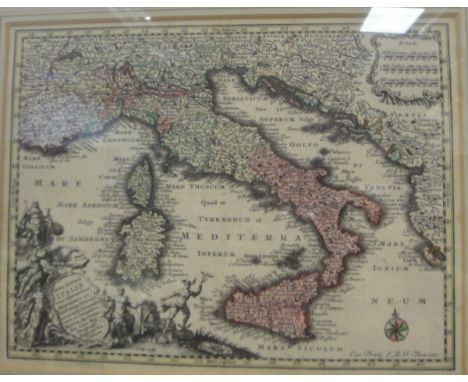
Lot 270
AFTER GIROLAMO ALBRIZZI (fl. 1673-1697) "Carta Geografica della America Meridionale" a black and white engraved map, later coloured, AFTER MATTHEW SEUTTER (1678-1757) "Nova Totius Italiae", black and white engraved map, later coloured and AFTER GEORGE MORLAND "Inside pf a country ale house", coloured engraving by W Ward, published May 6th 1800 by Wards & Co., London CONDITION REPORTS Map of South America measures approx 34.5 cm x 44 cm. Has a crease running down the centre and discolouration in several areas which appear to be water marks. Some areas of foxing and other discolouration. Unknown if stuck down. There is a further crease to the bottom right hand corner approximately 6 cm long in a curved shape. See images for more details.Map of Italy measures approx 20 cm x 26.5 cm. Has a couple of crease marks in various places and a hole to the centre. Some light discolouration. There is a rip to the bottom right hand corner approximately 1.5 cm in length. Various foxing and discolouration. Has general wear and tear conducive with age and use - as has the frame.

![THREE COUNTY MAPS [Two Maps of Durham] Blaeu (Johannes) Episcopatus Dunelmensis vulgo The Bishoprike of Durham, [c.1645 or la](https://cdn.globalauctionplatform.com/cce7398a-cacb-48b3-9d40-a6e100a6fa92/54972511-a347-44f5-a3bc-65f0f20ca224/468x382.jpg)
Lot 798
THREE COUNTY MAPS [Two Maps of Durham] Blaeu (Johannes) Episcopatus Dunelmensis vulgo The Bishoprike of Durham, [c.1645 or later, Amsterdam], engraved double-page map with hand colouring, embellished with arms, decorative cartouche and mileage scale; visible margin, unexamined out of modern gilt frame. Visible sheet 390 x 505mm [&] Morden (Robert) Episcopatus Dunelmensis Vulgo The Bishoprike of Durham, [1695 or later, London], hand coloured engraved map for Camden's Britannia, rather browned, unexamined out of modern frame, visible sheet 370 x 430mm [together with:] Speed (John) Huntington both Shire and Shire Towne with the Ancient Citie Ely Described, [1676], London, Bassett & Chiswell,, engraved map with hand colouring, inset town plans of Huntingdon and Ely, with royal and county armorials, decorative cartouche and mileage scale, rather browned, unexamined out of modern frame, visible sheet 380 x 505mm (3)

Lot 797
TWO BRITISH ISLES MAPS Visscher (Nicolaes) Magnae Britanniae Tabula; Comprehendens Angliae, Scotiae, ac Hiberniae Regna [c.1700 or later, Amsterdam], double-page engraved map with attractive hand colouring, ornate cartouche and mileage scale, winged putti carrying the arms of the three kingdoms, some visible margin. Plate 475 x 575mm [&] Blaeu (Johannes) Britannia prout divisa suit temporibus Anglo-Saxonum praesertim durante illorum Heptarchia [c.1645 or later, Amsterdam], engraved map with vivid hand colouring, flanked by strips of seven illustrations to each side, each enclosed in scrolling cartouches. They depict the founders of the seven Anglo-Saxon Kingdoms (to left), and the conversion to Christianity of their future rulers (to right). Some visible margin, plate 415 x 530mm. Both maps good copies, unexamined out of dark wood frames (2)
![THREE COUNTY MAPS Blaeu (Johannes) [all c.1645 or later, Amsterdam] Ducatus Eboracensis pars Borealis, The North Riding of Yo](https://cdn.globalauctionplatform.com/cce7398a-cacb-48b3-9d40-a6e100a6fa92/4ee6217a-85c4-4b96-fd93-ae492b442cca/468x382.jpg)
Lot 796
THREE COUNTY MAPS Blaeu (Johannes) [all c.1645 or later, Amsterdam] Ducatus Eboracensis pars Borealis, The North Riding of York Shire, engraved map with hand colouring, large decorative cartouche, armorials above, visible margins, plate 385 x 500mm, French text verso [&] Cumbria Vulgo Cumberland, engraved map with hand colouring, large decorative cartouche, mileage scale and armorials, margin visible, plate 415 x 500mm, French text verso [with:] Surria vernacule Surrey [featuring London], engraved map with hand colouring, armorials to left and right, some visible margin, plate 385 x 500mm, German text to verso. Good copies, unexamined out of gilt frames (3)


Lot 361
Wallis (Edward), 'Wallis's New Game of Wanderers in the Wilderness', a geographical race game over the continent of South America, with eighty four playing spaces laid out in a circular direction, the map featuring wild animals, mountains, figures and ships off the coast, a title vignette lower right, etching with extensive hand-colouring 68 x 50cm (27 x 20in)


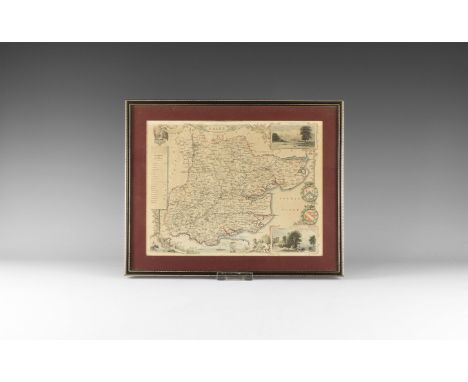
Lot 194
A late 19th century Henstock & Foulkes, Liverpool and District Cycling and Touring road map, an early 20th century Bartholomew's Pocket Atlas and Guide to Liverpool, a WH Smith & Sons Reduced Ordnance Map of Liverpool and Environs and three Liverpool Sailors' Home brass buttons, sold with related research (4).
![[TOPOGRAPHY]. TAUNTON (SOMERSET) Auction Particulars of a Most Important & Valuable Property known as 'Castle Green Estate'.](https://cdn.globalauctionplatform.com/c835a1c9-8ab1-4ec8-a7e0-a6da00d024b7/f77cd903-92af-4974-9c16-0efe36257c12/468x382.jpg)
Lot 161
[TOPOGRAPHY]. TAUNTON (SOMERSET) Auction Particulars of a Most Important & Valuable Property known as 'Castle Green Estate'... situate in the centre of the flourishing Town and Borough of Taunton, which will be offered for sale, on Tuesday, the 23rd day of July, 1861, at Clarke's Hotel, Taunton, printed by Dyer of Taunton, folding paper, 37.5cm x 25cm, complete with accompanying map, 34.5cm x 43cm, inclusive of margins.
![[MAPS]. ASSORTED comprising Richard Blome, 'A Mapp of the County of Somerset', 20cm x 24cm; Thomas Kitchin (1718-1784), 'A N](https://cdn.globalauctionplatform.com/c835a1c9-8ab1-4ec8-a7e0-a6da00d024b7/8c80ce05-9edd-497f-91b6-f47c39309742/468x382.jpg)
![[CLASSIC LITERATURE] Meynell, Wilfrid. Verses and Re-Verses, privately printed (at The Arden Press) for his family & friends](https://cdn.globalauctionplatform.com/c835a1c9-8ab1-4ec8-a7e0-a6da00d024b7/e20743ad-9a1c-4eb0-ab64-2f1c86c2b253/468x382.jpg)
Lot 138
[CLASSIC LITERATURE] Meynell, Wilfrid. Verses and Re-Verses, privately printed (at The Arden Press) for his family & friends, 1910, grey boards, top edges gilt, small octavo; Meynell, Alice. The Shepherdess & Other Verses, Burns & Oates, London, no date, paper covers, INSCRIBED & SIGNED TO DOROTHY RAWCLIFFE, with a manuscript poem and letter to the same in original postal envelope taped to inside front cover, octavo; another copy of the same, unsigned; Meynell, Violet. Verses, first edition, Secker, London, 1919, blue-grey boards, octavo; Rawcliffe, Dorothy. The Child's Visit to Fairyland, no date [1911], fawn cloth, map frontispiece, INSCRIBED & SIGNED BY AUTHOR to her mother, with a poem, on front free endpaper, octavo; Rawcliffe, Dorothy. Rafferty-Tafferty Primblekins and Other Follies for the Diversion of All Children, Old and Young, Platt, Wigan, 1927, stiff paper cover with onlaid title label, SIGNED BY AUTHOR, octavo; and two further duplicated works by Rawcliffe, (8).
![Owen (George) and Kip (William) [Pembrokeshire Map] Penbrok Comitatus olim Pars Demetarum [1607], hand coloured engraved map,](https://cdn.globalauctionplatform.com/a91258f8-b4cd-43e6-a448-a6e100b36857/889ee392-151b-47aa-9e60-d4776b0165e5/468x382.jpg)
![Blaeu (Johannes) [Map of Durham] Episcopatus Dunelmensis vulgo The Bishoprike of Durham, c.1645 or later, Amsterdam. Engrave](https://cdn.globalauctionplatform.com/a91258f8-b4cd-43e6-a448-a6e100b36857/fa369f81-d38b-4749-e7eb-465882f69cb2/468x382.jpg)
Lot 72
Blaeu (Johannes) [Map of Durham] Episcopatus Dunelmensis vulgo The Bishoprike of Durham, c.1645 or later, Amsterdam. Engraved double-page map with hand colouring, embellished with arms, decorative cartouche and mileage scale. French text to verso. Both sides glazed, wide visible margins, unexamined out of thick gilt frame. Sheet 485 x 585mm.
Lot 51
HULL AND THE EAST RIDING Tickell (John) The History of the Town and County of Kingston-upon-Hull, 1798, Hull, Thomas Lee & Co., thick 4to, pp. 940 (plus Addenda, pagination duplicated pp. 925-932), illustrated engraved title, an extra-illustrated copy with five engraved plates tipped-in additional to the 17 called for in list to rear. Contemporary rebacked rubbed calf, closed tear to plan and some light foxing but generally a good sound copy. [together with:] Cragg's Guide to Hull, 1817, Hull, J. Craggs, 8vo, folding plan frontis, original rubbed and stained printed boards, upper hinge very weak; The New Hull Guide: A Picture of Modern Hull, 1880, Hull, Peck & Son, 4to, pp. 186, large paper edition limited to 25 copies, C.S. Todd's copy, multiple illustrations, folding maps (one with tear), foxed, original stamped cloth; Symons (John) Hullinia: or, Selections from Local History, 1872, Hull, W. Adams, 8vo, pp. 152, illustrations, 1889 ALS from the author loosely inserted, original decorated red cloth boards, rubbed and bumped, with edge ware; Woodcock (Rev. Henry) The Hero of the Humber; or the History of John Ellerthorpe, 1868, London, Elliot Stock, 12mo, pp. 181 plus adverts, frontis. portrait, original stamped cloth gilt, spine faded, weak upper hinge; De Sawtry (Geoffrey) [Pseudonym] The Churches of Holderness, Parts I [&] Part II, 1837-38, Hull, Weston Howe [&] Mary Montgomery, two very rare 8vo pamphlets attacking the state of the Church of England in Yorkshire, original printed wraps, well preserved in modern hard cloth boards; Lamplough (Edward) Hull Sonnets [&] Hull Extracts, 1901 [&] 1904, Hull, 8vo (very) limited editions privately printed by Lamplough, Sonnets being dedicatee J.R. Tutin's copy, with his bookplate and the author's presentation inscription to him, both vols in rubbed and bumped diced morocco over cloth boards, with weak upper hinges, Extracts with head of spine detached [with:] Brayshaw (Thomas, Compiler) The Yorkshire Portion of Leyland's ''Itinerary.'', 8vo offprint from The Yorkshire Archaeological Journal, folding map, original blue cloth decorated boards, lettered in gilt (10).
Lot 54
Young (Rev. George) A Geological Survey of the Yorkshire Coast: Describing the Strata and Fossils Occurring between the Humber and the Tees, from the German Ocean to the Plain of York, 1822, Whitby, G. Clark, 4to First Edition: [i-]iv, pp.328, plus Index, list of Subscribers and 1 p. advert, engraved frontispiece, double page hand-coloured engraved geological map of Yorkshire Coast, double page hand-coloured sectional chart of Strata, plus 17 hand-coloured lithographic plates of fossils (complete as list). Rubbed and bumped contemporary half green morocco over marbled boards, contents generally good, offsetting to title and only minor soiling and browning. Old ownership label to front pastedown, two ownership inscriptions to f.f.e.p.

Lot 71
Christison (George W.) Map of the Eastern Himalayan Mission Field of the Church of Scotland Reduced and Compiled from the Indian Government Maps and Information Supplied by the Missionaries. 1905, West Norwood, London Privately printed(?) scarce lithographic facsimile map coloured in outline showing part of northern India, close to the borders with Nepal, Bhutan, Tibet and Bangladesh. Issued by the Church of Scotland Mission, with explanatory Note. Printed border 930 x 780mm. Some creasing, soiling and staining, extremities with a few nicks and tears, two closed tears through upper right corner.
Lot 73
Greenwood (Christopher) Map of the County of York… by Order of The Honourable Board of Ordnance… Surveyed in the Years 1815, 1816 & 1817… 1817, Leeds, Robinson, Son & Holdsworth, Wakefield, J. Hurst & C. Greenwood. First edition of this engraved large-scale map in early and unfaded wash colour, printed on nine folding linen-backed folio sheets. Engraved by S.J. Neele, total dimensions approx. 1860 x 2160mm. Large calligraphic title and Dedication, altitudes of principal mountains upper left, key below. Some surface soiling, linen at verso browned and spotted. A must-have survey for the map collector and an impressive production, combining accuracy, historical interest and decorative appeal.
![Braun (Georg) and Hogenberg (Frans) [Plan of Brussels] Bruxella, urbs aulicorum frequentia, fontium copia, magnificentia pri](https://cdn.globalauctionplatform.com/a91258f8-b4cd-43e6-a448-a6e100b36857/fa66c3f4-bf44-41be-d373-31d0c0e39a30/468x382.jpg)
Lot 74
Braun (Georg) and Hogenberg (Frans) [Plan of Brussels] Bruxella, urbs aulicorum frequentia, fontium copia, magnificentia principalis aulae, [1572, Cologne], hand-coloured engraving from Volume I of the famous atlas of city plans 'Civitates Orbis Terrarum'. Unexamined out of modern frame, no obvious defects, Latin letterpress verso, mount window 330 x 470mm. [&] [Plan of Amsterdam] Amsterdam des selfs omleggende landen. [1726, Amsterdam], hand-coloured engraved plan showing water supply and irrigation channels, from Caspar Commelin's 'Beschryvinge van Amsterdam'. Evidence of folds and other creases, unexamined out of modern frame, mount window 420 x 580mm. [together with:] Blaeu (Johan and Willem) Suthsexia, vernacule Sussex. [c.1645, Amsterdam], engraved county map with hand-colouring, inset coats of arms above and ships below, French text verso. Unexamined out of modern frame, margins visible, mount window 395 x 530mm; Jansson (Jan) Comitatus Nottinghamiensis sive Nottinghamshire, [1646 or later, Amsterdam], engraved county map with hand-colouring, elaborate cartouche for title and scale, with heraldic shields inset, German text to verso. Unexamined out of modern frame, margins visible, mount window 420 x 530mm .(4)

Lot 21
YORKSHIRE/NORTH EAST RAILWAY MAPS Two sectionalized linen-backed maps printed in colours, folding into 8vo cloth lettered in gilt. Railway Map. North Eastern System &c. 1883, London, Smith & Ebbs, 1050 x 940mm open [&] Railway Clearing House Official Railway Map of Yorkshire District, 1936, London, Railway Clearing House, 1210 x 1080mm open, both with light age toning only, binding with light edge ware (2).

Lot 120
COAL MINING, NORTHUMBERLAND AND DURHAM Oliver (William, Mining Engineer) Map of the Coalfield, of Northumberland & Durham, shewing the ascertained Collieries, Pits, Faults, Dykes and other Interruptions with the Railways & Ports of Shipment Constructed for the Coal Trade, 1851, Newcastle, M. & M. W. Lambert Very large lithographic map in original outline colour, in 24 sections, mounted on linen, folding into original diced morocco boards (worn, upper cover lettered in gilt, detached), with metal clasps. Surveyed at 1 1/4 inches to the mile, approx. 210 x 116cm open. [together with:] Sopwith (Thomas) An Account of the Mining Districts of Alston Moor, Weardale and Teesdale... 1833, Alnwick, W. Davison, 8vo; viii, pp. 183 plus pp. 5 of adverts, hand-coloured map frontis, wood-engraved illustrations. Original faded and worn cloth with remains of spine label, extremities bumped; two old ownership inscriptions. A scarce work. (2)
![[BIBLE, Geneva version] The Bible, that is, The Holy Scriptures conteined in the Olde and Newe Testament, translated accordi](https://cdn.globalauctionplatform.com/a91258f8-b4cd-43e6-a448-a6e100b36857/deb1237c-c10f-41f0-a346-ce63eccb702d/468x382.jpg)
Lot 56
[BIBLE, Geneva version] The Bible, that is, The Holy Scriptures conteined in the Olde and Newe Testament, translated according to the Ebrew and Greeke... Imprinted at London: by the deputies of Christopher Barker, 1599 [but later, c.1640(?), probably Amsterdam]. Small 4to (215 x 165mm), two pictorial general titles plus New Testament title, the NT with separate pagination, letterpress in two columns with marginalia, numerous woodcut initials, decorations and illustrations, incl. map of the Holy Land. [Bound with:] The CL. Psalmes of David, in Scots meter. After the forme that they are used to bee sung in the Kirke of Scotland, 1632, Edinburgh, heires of Andro Hart, some fore edge margins cropped; single leaf 'Forme of Prayers' at rear of volume. Smart later calf gilt over boards, a little rubbed and bumped, marbled e.p.s., soiling and dampstaining throughout, large stain pp. 6-8, nicks and worm trace to both general titlepages, upper text block shaved very close to text in places, old ownership inscription to f.f.e.p. Sold not subject to return, w.a.f.
Lot 65
Cramer (John Anthony) Graecia Antiqua et Nova una cum Insulis circumjacentibus, 1827, Oxford, J. Parker, engraved map by Findlay hand-coloured in outline, mounted on linen in 42 sections, folding into very scuffed and rubbed reverse calf boards, split at joint so upper cover detached; the map with only light soiling and staining, no tears or loss. Fully open 1260 x 980mm. [together with:] Anderson (William) The Works of Lord Byron, [c.1870], Edinburgh, A. Fullarton & Co., in two large 8vo volumes, frontispieces, engraved pictorial and printed titles, illustrated with numerous engraved plates, contemporary rubbed red morocco gilt, a.e.g. [&] Wilde (Oscar) The Happy Prince And Other Tales, 1889, London, David Nutt, large 8vo Second Edition, illustrations by Walter Crane and Jacomb Hood, original printed boards stained, spine lacking, foxing (3).
Lot 50
YORKSHIRE/NORTH EAST HISTORY AND ANTIQUITIES Ord (John Walker) The History and Antiquities of Cleveland, 1846, London, Simpkin & Marshall, 4to., first edition, rebacked polished calf. With portrait frontispiece, additional pictorial title, plates, and folding map and pedigree. List of Subscribers to rear. Plates with some foxing/staining; Graves (Rev. John) The History of Cleveland, 1808, Carlisle, Jollie & Sons, 4to., frontispiece and additional pictorial title, engraved plates, folding pedigree and folding map, hand-coloured in outline. Bound to style in 20th century leather over marbled boards; Speight (Harry) Romantic Richmondshire, 1897, London, Elliot Stock, 4to, plates, folding map. Smart late 20th century binding by Conway of Halifax (with their label inside rear cover); Baker (Joseph Brogden) The History of Scarborough from the Earliest Date, 1882, London, Longmans, Green & Co., 4to, number 4 from an edition limited to 100 copies, multiple plates and a folding map, contemporary morocco over purple cloth, with armorial in gilt to upper cover; Hinderwell (Thomas) The History and Antiquities of Scarborough and the Vicinity, 1811, York, 8vo, mottled calf, rebacked. Facsimile replacement folding map Vicinity of Scarboro (5).
![GIBRALTAR HUNTING MAP Hunting Map of Country near Gibraltar, [c.1880s], London, Stanfords, sectionalized chromolithographic m](https://cdn.globalauctionplatform.com/a91258f8-b4cd-43e6-a448-a6e100b36857/1495ac55-fec3-4b98-a577-5c32019c71cc/468x382.jpg)

Lot 109
PRINTS AND PLANS, YORKSHIRE INTEREST Dunning (R.) South View of Ripon Minster, 1813, Ripon, hand-coloured aquatint engraved by R. & D. Havell, green mount, wrapped in cellophane; Walmsley (Thomas)? Castle Acre Priory, Yorkshire, 1811, London, J. Deeley, hand coloured aquatint, unexamined out of thin Hogarth frame, Parker Gallery label verso, image 270 x 375mm; Couse (John) ...View of Wentworth House in Yorkshire, [c.1760], vignette etching on laid paper, sheet 225 x 400mm, folds; [Anon.] High Harrogate, c.1830s, hand-coloured lithograph on india paper, sheet 280 x 380mm; A Visit to Harrogate, [c.1880s], one folio sheet mounted, hand-coloured vignette wood engravings [with:] [Anon.] Plan of the Intended Navigable Canal from Leeds to Selby... 1774, hand-coloured folding engraving for the Gentleman's Magazine, with inset antiquities; Fowler (Charles) Plan of several Turnpike Roads between Leeds and Doncaster..., 1822, Leeds, hand-coloured engraving by Neele & Son, vertical fold crease; large folio chromolithograph Plan of Leeds [c.1880]; Dewsbury (New Borough), Proposed Parliamentary Boundary 1868, Ordnance Survey zincograph map with companion letterpress sheet; also three sheets of Yorkshire town plans by R. Creighton; a Plan of Ports and Harbours on the East Coast of England pub. Fullarton, Edinburgh; and two illustrations of Yorkshire public buildings from The Building News c.1890 (15).
![Stanford (Edward, Publishers) [Tees Mouth to Whitby], large lithographic map with some outline colour added by hand, finger-](https://cdn.globalauctionplatform.com/a91258f8-b4cd-43e6-a448-a6e100b36857/4b0468ef-212f-487f-99b2-86087d4eb5f1/468x382.jpg)
Lot 68
Stanford (Edward, Publishers) [Tees Mouth to Whitby], large lithographic map with some outline colour added by hand, finger-soiled, a little browned, linen-backed and folding into scuffed maroon cloth boards with publisher's label to upper cover, inscribed in ink. [With:] Two Ordnance Survey maps, Kielder, 1925 [&] Ryedale District of North Yorkshire, 1856, Kielder printed on 'War Substitute Paper'; both sectionalized, linen-backed, and folding into marbled paper covers but lacking cases/covers. Time-stained, no significant loss (3).
-
109198 item(s)/page