We found 109182 price guide item(s) matching your search
There are 109182 lots that match your search criteria. Subscribe now to get instant access to the full price guide service.
Click here to subscribe- List
- Grid
-
109182 item(s)/page


Lot 365
S. Parker (17th/18th Century) - Coloured engraving - "A Plan of the City's of London, Westminster and Borough of Southwark; With the New Additional Buildings; Anno 1720", revised by John Senex (fl. 1690-1740) with cartouche to upper left with dedication and references to Westminster, London and Southwark below the map, 19.5ins x 23ins, in gilt frame and glazed
![Militaria including:-[Zajdlerowa, Zoe]"The Dark Side of the Moon with a preface by T S Eliot", Faber & Faber 1946, dark blue](https://cdn.globalauctionplatform.com/7adfe98e-e826-44f4-95ff-a86a009d73bc/333f9223-4c7e-4a35-87a9-f6933147b738/468x382.jpg)
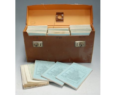
Lot 12
Militaria including:-[Zajdlerowa, Zoe]"The Dark Side of the Moon with a preface by T S Eliot", Faber & Faber 1946, dark blue bds, dj not price clipped but very chipped Hood, Stuart "Pebbles from my Skull", Readers Union Hutchinson, London 1964, maroon bds, djPudney, John "Dispersal Point and Other Air Poems", The Bodley Head 1942Austin, A B "Birth of an Army", Gollancz 1943, folding map frontis, photographic ills, another folding map, dj rather worn Graham, Stephen"A Private in the Guards", Macmillan 1919, blue bds with regimental crest on front boardWhittlesey, Derwent "German Strategy of World Conquest", Farrar & Rinehart, New York 1942Aberigh-Mackay, George"21 Days in India, being the tour of Sir Ali Baba, K.C.B.", W H Allen 1880, 2nd edition, bds rather stained and rubbed, SO Book 135GR supplied for the public service and SO Book 130, a scrapbook full of cuttings, cartoons and another and other volumes
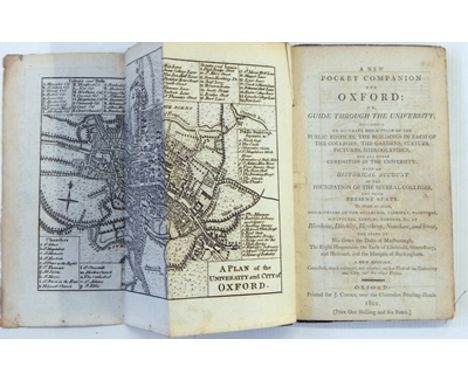
Lot 44
"A New Pocket Companion for Oxford: or a guide through the university ... descriptions of buildings ... at Blenheim, Ditchley, Heythrop, Nuneham and Stow ...", new edition, Oxford, printed for J Cooke 1801, folding map of Oxford frontis, six plates, bookplate inside fb for Charles Parr Burney (believed to be Fanny Burney's brother), marbled bds, backstrip with loss and all rather bumped

Lot 200
The Coysh Collection - 'Almacen de Gamba y Co - A 19th century pearlware blue transfer printed dessert plate decorated with a map of Cuba and a Spanish poem, c. 1820-30. maker unknown but possibly W. Adams, bears Pulver exhibition label 1974, 22.5 cm diam.NB:Illustrated and described in Blue-Printed Earthenware 1800-1850, page 98, A. Coysh. This plate is almost certainly part of a special order for use in a Havana Coffee House called 'La Cafetera' Condition Report Some surface scratches. Underside crazed


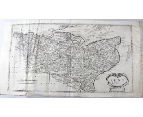
Lot 576
Robert Morden (British, 1650-1703): a collection of seven 18th century maps, including the counties of Kent, Sussex, Surrey and Nottinghamshire, all uncoloured, and Durham, Lincolnshire, and Northamptonshire, hand coloured, sold by Abel Swale and Churchill, all approximately 38 by 44cm, apart from Kent, 35 by 63cm, all unframed, together with a collection of assorted 18th and 19th century maps, including small county maps, John Cary Oxfordshire, Dugdales and Fullartons, R. Bonne (French, 1727-1795): 'Royaume d' Angleterre, hand coloured, 24 by 35cm, together with a 20th century Administrative County of Lincolnshire map, a 1972 reproduction of Marrat's 1817 city of Lincoln, and O.S.1884 Geological survey of Wymondham, hand coloured, 35 by 49cm. (15)

Lot 112
1916 - 1966 A collection of commemorative publications. A colour illustrated calendar published by Irish Art Publications; The E.S.B. Journal, April 1966, including a map of Dublin showing the principle sites of the Rising; a commemorative concert programme; An tUltach, official magazine of Comhaltas Uladh, the Ulster branch of Conradh na Gaeilge, April 1916; a set of Easter Rising 1916 Commemorative Stamps, April 1966. (6)


Lot 176
17th century maps of Ireland by Gerard Mercator and Johannes Jansson. Five hand-coloured, engraved maps, as published in the Atlas Novus between 1636 and 1642. Jansson's Hibernia Regnum Vulgo Ireland; Mercator's untitled map of the northern half of Ireland; the southern half of Ireland, titled Hiberniae Pars Australis; east Ulster, titled Ultoniae Orientalis pars; and Carlow, titled Udrone Irlandia in Carlag Baronia. (5) Attractively framed en suite. 15.50 by 20in. (39.4 by 50.8cm)


Lot 181
1755, Map of the British & French Plantations in North America A hand-coloured, engraved map of the British & French Colonies in North America, the Mouth of the Mississippi to the St. Lawrence, Newfoundland and contiguous parts of Labrador, centered on Nova Scotia, in three sheets, joined, published by London Magazine. 17 by 21in. (43.2 by 53.3cm)

Lot 182
1773 Map of Ireland by John Rocque. The Kingdom of Ireland Divided into Provinces Counties and Baronies. Showing the Archbishopricks, Bishopricks, Cities, Boroughs, Market Towns, Villages, Barracks, Mountains, Lakes, Bogs, Rivers, Bridges, Ferries, Passes...". With large decorative title cartouche in top left corner and inset map of the sea coasts of Great Britain and Ireland bottom right. A large engraved four-sheet map, published by Robert Sayer for Kitchin's General Atlas, cut into 48 sections and laid on linen for folding, attractively framed in four frames. Each frame 28 by 23.25in. (71.1 by 59.1cm)


Lot 193
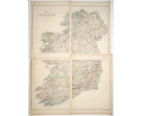
1840 Weller's Weekly Dispatch Atlas, maps of Ireland and Dublin, Belfast, Cork and Killarney and their environs. A coloured, lithograph map of Ireland in four, separate sheets and individual maps of Dublin, Belfast, Cork and Killarney and their environs. Each sheet 19.50 by 14in. (49.5 by 35.6cm)
Lot 199
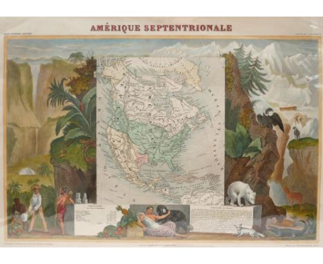
1845 Illustrated map of America, by Victor Levasseur. A hand-coloured. engraved map of North America (Amerique Septentrionale), by Levasseur, Atlas Universel Illustre, Paris, ca. 1845. North America showing the United States` claims into present-day Canada reflecting the Oregon boundary dispute. The Republic of Texas is shown, and Mexico`s northern border is drawn according to the Treaty of 1819 (here misprinted as 1810). The map is surrounded by beautifully engraved scenes of North and Central America including wildlife, a ship stranded in the polar sea and a Mayan temple. 14.40 by 20.25in. (36.6 by 51.4cm)


Lot 202
1877 Map of North America by JP Morales. A hand-coloured printed map of America, America del Norte, with large decorative panorama showing Fur-traders, early farmers, native Americans, Conquistadors, English planters and buffalo, from Atlas Geográfico Universal. 23.50 by 32in. (59.7 by 81.3cm)
Lot 203
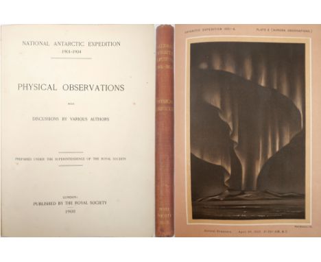
Various authors. National Antarctic Expedition 1901-1904, Physical Observations and Discussions. London, The Royal Society, 1908, first edition; folio, v, [1], 192 pp., 21 plates with one folding and including six plates of aurora observations in muted grey, blue and brown, also a double page colour map of Laurie Island; original cloth,

Lot 205
Lyon, Capt. G F. A Brief Narrative Of An Unsuccessful Attempt To Reach Repulse Bay, Through Sir Thomas Rowe's "Welcome," In His Majesty's Ship Griper, In The Year MDCCCXXIV. London: John Murray, 1825, octavo, pp. xvi, 198, [2]. folding engraved map (frontis.), seven engraved plates and two text illustrations, rebound navy calf, gilt.

Lot 244
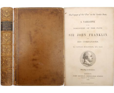
McClintock, Captain Francis L. A Narrative of the Discovery of the Fate of Sir John Franklin: Voyage of the Fox. London: John Murray, Albemarle Street. 1859; octavo, tan gilt morocco. A first edition of this important work on the fate of John Franklin's polar expedition. Complete with four maps and fifteen plates. With folding map now tipped in to rear.

Lot 262
Tolkien, J.R.R. Lord Of The Rings trilogy - The Fellowship Of The King, The Two Towers and Return Of The King, First Editions. Allen & Unwin, London 1954-1955. Three volumes, octavo (225 x 145mm). Finely bound in black leather, titles and decoration to spines gilt, "Eye of Sauron" to front boards gilt, marbled endpapers, all edges gilt. Housed in a matching leather clamshell. An excellent set. Each volume has a map illustrated by the Author.With loosely inserted slip of paper inscribed 'If you would like a signature for 'The Lord of the Rings', you can stick this in with my good wishes. J.R.R.Tolkien 20/6/73'.Very Fine. A few minor flaws. A one-inch scuff to the the gilt edge of The Return of the King. A small area of very light clouding to the leather front cover of each book and to the clam-shell case.

Lot 87
1917. Small archive relating to Ambrose Kneafsey, 2nd Liutenant,1st Royal Dublin Fusiliers, later Captain, Tank Corps. Includes a trench map of Langemarck, 1917, inscribed by Lieutenant Kneafsey on reverse, two aerial photographs of trenches at Houthulet Forest 1917, photographs (6) of tanks 1917-1919, including three destroyed in battle, a couple inscribed by Kneafsey, also with this lot some postcards 1950s-1960s, mainly of Switzerland, also a box of glass plate photographs (25, 3 inches square), mainly by Mason, Dublin, mostly of old prints, and a 1952 Illustrated magazine for the death of King George VI. (40+)


-
109182 item(s)/page