We found 109182 price guide item(s) matching your search

Refine your search

Year

Filter by Price Range
  • List
  • Grid
  • 109182 item(s)
    /page

Lot 260

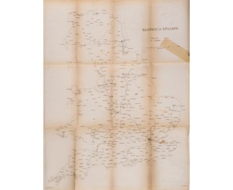
NO RESERVE Railways.- Mudge (Richard Zachariah) Observations on railways, with reference to utility, profit, and the obvious necessity for a national system, first edition, presentation copy from the author, folding engraved frontispiece map, folding letterpress table, large ink ownership signature to title, map browned at folds and with tape repair, some browning, mostly light, occasional spotting, original cloth, sympathetically rebacked, preserving original title part of spine, covers soiled, [Ottley 408], James Gardner, 1837; and another, Turnpike roads, 8vo & small 4to (2)

Lot 75

[Defoe (Daniel)] The Life and strange surprising adventures of Robinson Crusoe; of York, mariner, 2 vol., "Tenth edition", engraved frontispiece, folding map and 12 plates, some spotting or foxing, occasional staining, lightly browned, contemporary speckled calf, gilt, spines in compartments and with red morocco labels, vol.1 upper cover detached, corners worn, rubbed, Printed for T. and T. Longman, C. Hitch and L. Hawes [& others.], 1753; and a 1792 edition of the same, 12mo (3)

Lot 290

OLYMPICS, 1948 London Olympiad, football programmes (2), A v B (British Olympic Trial Match), 8th May; Bulgaria v Great Britain, 23rd Oct 1955 (qualifying match), London Underground pocket-size map, folds, G to VG, 3

Lot 2084

Brown leather holster for a Browning Hi-Power pistol (dummy pistol within) and map pouch. P&P Group 2 (£18+VAT for the first lot and £3+VAT for subsequent lots)

Lot 355

Irene Lesley Maine,The Church of St Mary's Turville,signed, watercolour, dated 1984,18 x 26cm,The Vicar of Dibley featuing Dawn French was filmed in Turvile Church.An antiquarian map of Market Harborough, titled " A Plan of Town of Market Harborough by Samuel Turner and Rowland Rouse" a later copy re-painted in watercolours.

Lot 105

Wall clock modelled as a map of Africa, two snakeskin clutch bags and a wicker wall hanging modelled as a targe.

Lot 220

Unframed charcoal and pencil drawings, various subjects, signed indistinctly, an unframed scroll of yacht racing rules and an unframed map of the Mediterranean Sea.

Lot 24

After Johan Blaeu Hand-coloured map of Galloway and another of the Southern Part of Dumfriesshire.  (2)

Lot 586

Tomkins (Charles) A Tour to the Isle of Wight, 2 vols, London 1796 CONDITION REPORT: Covers worn with bumped corners and rubbed edges, scattered scuffs and minor detachments to marbled boardsLeather spines dry and with tears and loss to upper and lower spinesBookplate for John White to both volumes and inked to FEPsFoxed endpapers and scattered foxing throughoutVol I Fold out map with tears and foxingPlates present with foxing and light tanningDiscolouration to last few pages Vol II2 loose platesPlates present with some loose and soiled. Heavy foxing and localised browning to endpapers.

Lot 546

A series of 1960s 'Headlight patrol' breakdown service advertising hoardings,photographic images of a liveried Series 2 Landrover and uniformed officer, together with another with a road map and staff152 x 122cm (5)Condition ReportAll with damp damage to the borders, two with more damage to the centre top edge and one side on another losing some of the image.

Lot 515

A brass bound glass top coffee table depicting a map of the world together with a similar nest of three tables.

Lot 684

A selection of old maps including Bacon's New Map of The Isle of Wight and others

Lot 3041

The Royal Geographical Society Silver Map, with information booklet

Lot 3081

17th Century map of England and Wales, hand tinted and framed 62x52cm

Lot 31

A collection of assorted items to include: 4 silver spoons by Cooper Bros & Sons 1929, 1934 and 1935 (53.8g); A Birmingham hallmarked silver mustard/condiment spoon, 1897 by Joseph Goster (5.4g); A 925 silver toothpick/pin holder (8.2g); along with 2 pairs of silver plated sugar tongs; A silver plate heart-shaped jewellery box; a silver plate teaspoon; a silver plate meat skewer; also another silver plate spoon; a silver plate apostle spoon; 3 silver plate place named / commemorative spoons and knife; a Caithness glass and silver plate spoon; a silver plated brush; a brass oriental, bone page marker; a pewter mustard pot by James Dixon and Sons, a boxed set of 4 silver plate Royal wedding spoons, an Ordnance Survey map, a small brass telescope, a plated cylinder box for formamints, English and Swedish 1200 words miniature book, a cylinder brass lid/weight, pencil leads in case, and 3 stone miniature eggs.

Lot 1105

PiL/STRANGLERS - LP RARITIES. Expert pack of 2 x LP release rarities. Titles are PiL - Metal Box (UK original, METAL 1 - sharp Ex/Ex+ condition records/with spacers, no insert/Ex very clean outer metal box with very little of the usual oxidization normally seen) and The Stranglers - The Raven (UK ltd edition og with 3D sleeve, UAG 30262, inner with Joh Bjelke-Petersen and map - Ex+ very clean record/Ex sharp sleeve).

Lot 589

Framed topographical map, Accurate map of the old Netherlands and some adjacent regions in Amsterdam by Isaak Tirion, situation around the year 1000, 29x35 cm, incl. frame 57x62 cm in total

Lot 587

Topographical map, New Kart of the United Netherlands by Isaak Tirion, 29x33 cm

Lot 590

Framed topographical map of the diocese of Utrecht, made by Evert Simonsz Hamersvelt cartographer Balthasar Florisz van Berckenrode, situation ca. 1650, 37x48 cm, incl. frame total 61.5x72 cm

Lot 591

Framed topographical map of the VII provinces of the Netherlands/Belgium, by Christophoro Weigelio, situation ca. 1700, 27x34 cm, incl. frame in total 57x62 cm

Lot 588

Framed topographical map of Die Grafschaft Flandern, situation ca. 1700, 27x35 cm, incl. frame 57x62 cm in total

Lot 195

EARLY GERMAN MAP FRAMED PRINT, COLOURED 1930'S 80CM X 57CMS

Lot 1503

A Vintage Aluminium Michelin Motoring Map Sign Mounted On Hard Board, 58cm x 82cm (overall Size 92cm x 69cm)

Lot 1592A

C19th Reverse Painting on glass, Landscape scene A/F, 44 x 36cm, F & G and a Framed Silk Map of England, 50 x 44cm, F & G

Lot 1303

A large Map set of Salopettes

Lot 1304

A large Map fishing jacket

Lot 906

A map of Suffolk together with various prints and a mirror

Lot 22

Palitoy, Action Man - A Palitoy blonde flock haired and bearded Action Man figure in Mountaineer outfit. The hard hand figure is stamped 'Made in England by Palitoy Under License From Hasbro © 1964' to rear of torso, and appears Very Good overall. The figure comes with orange Action Man anorak, jersey, knee breeches, socks, black lace up boots, , ice hammer, ice axe with rope, pitons, carabiners, orange helmet, green goggles map case and map, plus High Altitude equipment such as oxygen tanks, airline bladder, face mask and rope ladder - outfit and accessories show signs of play and display ranging Fair Plus - Good. (This does not constitute a guarantee)

Lot 25

Palitoy, Action Man - A Palitoy blonde painted hard head Action Man figure in Mountaineer outfit. The hard hand figure is stamped 'Made in England by Palitoy Under License From Hasbro © 1964' to rear of torso, and appears to be in Very Good condition overall. The figure comes with orange Union Jack anorak, khaki jersey, knee breeches, green socks, khaki jumper, brown lace up boots, ice hammer, ice axe, rope, pitons, carabiners, white helmet, green goggles, plus blue rucksack containing camping stove, three suction cups, compass, canteen, red torch, map case and map, mess tin including cutlery - outfit and accessories show signs of play and display ranging Fair Plus - Good. (This does not constitute a guarantee)

Lot 364

NINE BOXES OF ASSORTED SUNDRIES, to include a Miranda camera stand, a box of sea shells, a Coopers of Stortford record player with built in speakers, grey leather briefcase, men's leather belts and wallets, a box of artificial fruit, box of ties, playing cards, a globe, a Canon AF7 Sureshot camera, an Agfa video recorder, a boxed The Poti rally illuminated map magnifier, an unused porcelain bird feeder, a Route 66 Cri Ta Bear, a Walt Disney World 'Safari Minnie Mouse', etc (s.d) (9 boxes + loose)

Lot 426

A PRINTED LINEN MAP OF THE TRANSVAAL AREA OF SOUTH AFRICA AND SIMILAR LINEN HANDKERCHIEF MAP, the map printed with portraits of President Stephen John Paul Kruger and The Right Hon Joseph Chamberlain, measures approximately 63cm x 59cm, together with a large linen handkerchief printed with music and lyrics by Rudyard Kipling for 'The Absent-Minded Beggar', also featuring a map of Transvaal and printed portraits of Lord Roberts and Queen Victoria, approximately 40cm square (2) (Condition report: generally good condition, some staining)

Lot 97

Robert Morden, a hand-coloured engraved map of Hampshire, 15" x 18" (38 x 46cm).

Lot 113

Vintage map book, The Country of Your Surveyd, 1973, published by Harry Margary, Lympne castle kent

Lot 114

Vintage map book, Two Hundred and Fifty years of Map- Making in the country survey

Lot 115

Vintage map book, Early maps of the british isles a.d 1000 a.d 1579

Lot 159

Vintage map book, 250 years of map making in the country of sussex 1575-1825 by R.A Skelton

Lot 161

Vintage map book, An exact survey of Citys of London Westminister by John Rocque in 1746

Lot 289

Vintage map book, Half inch map series of Great Britain

Lot 319

Vintage map book, a topographical survey of the country of berks

Lot 63

Vintage map book, a map of the country of Essex by John Chapman and Peter Andre

Lot 409

A framed tapestry scene together with framed John Speed repro map of Stafford Countie and Towne, largest 59 x 46cm (2).

Lot 404

A 19th Century fox hunting engraving, Francis Duckenfield Astley Esq., and his harriers, a map of Sheringham, Norfolk, other prints and watercolours (8)

Lot 218

An 1835 hand-coloured folding map, 'Crutchley's New Plan of London shewing all the new and intended improvements to the present time' ('Published May 1st 1827  .... A New Edition Improved to 1st Jany. 1835') (45cm x 86cm unfolded and 8.7cm x 15.2cm folded)

Lot 222

A mixed lot comprising:Carly Coomer - a signed pair in pen and wash, 'Leaping Hare' and 'Running Stag' (frame sizes 27cm x 33.5cm);Tiny Nijman S.W.A. - an etching, 'Train Crossing Bridge' (1 of 50) (14cm x 19cm);after Norman Ives and Jean-Michel Folon - two stamped Melinex foils from the ICI 'Reflections' series (each 24.5 square cm and boxed together);a circa 1825 map engraving, 'Gloucestershire', published by Pigot & Co, 17 Basing Street, London. 

Lot 2147

19th Century Embroidered Map Sampler of England and Wales, worked in an oval with coloured boundaries for the counties and a decorative floral rose garland surround, in a mahogany frame, 64cm by 69cm

Lot 72

A Great War Houghton and Butcher London War Department, Map Board with Clinometer and Compass dated 1915, as used by the Royal Flying Corps and Cavalry

Lot 631

John Speed, Africae, described the manners of their habits, and buildings...; later hand-coloured map, engraved by Abraham Goos, with eight inset views of important cities including Alexandria, Tangier and Tunis to top horizontal margin, the side margins with engravings of indigenous people, originally published by Thomas Bassett & Richard Chiswell in 1676, 31 x 51.5cm Note: This is one of the first maps of Africa to be prepared by an English cartographer and contains a number of inaccuracies, including fictitious mountains, rivers and lakes. Please refer to department for condition report

Lot 1296

Gerardo Valk et Petro Shenk; Dvcatvs Eboracen Sis. Anglise Yorkshire, C18th later hand coloured map, 40cm x 51cm

Lot 2075

The Grange Goathland - Charlton (Lionel) The History of Whitby and of Whitby Abbey, York, 1779, half-leather binding with 5 raised bands, pull-out map of Whitby and 4 plates, & Charlton (Lionel)The History of Whitby and of Whitby Abbey, Printed by A.Ward and sold in London by T.Cadell, 1779, disbound, pull-out map of Whitby and 3 plates (both a/f)

Lot 2083

The Grange Goathland - Scarborough and Whitby folding map, sheet 14, 2nd imp, pub. 1985 by Redwood Burn Ltd, Trowbridge, Wiltshire, for David Charles Publishers, monochrome, framed, 75cm x 101cm

Lot 204

STREET MAP OF NEW ORLEANS,along with a Harpers map of Mississippi and a Sir William Russell Flint Print (3)

Lot 494

WALL MOUNTING DISPLAY RACK,along with a framed map of Suffolk and another map (3)

Lot 238

Thomas Jeffrey ''The County of York''Engraved sectional map, 20th century re-print

Lot 262

Ball (Charles), The History of the Indian Mutiny ....Volumes 1 & 2, plates, hand-coloured map, half leather bindings

Lot 1147

Blome (Richard)Jerusalem, no date, 17th century engraved birds-eye plan, framed and glazed;Blome (Richard), Canaan, comonly called the Holy Land ..., 1687, engraved map, framed and glazed;Blundell (J.) engr. The Elevation of the Temple of Jerusalem etc. multiple engraved views on one sheet, 18th century, framed and glazed;Haymood, Arabian Gulf or Red-Sea from D'Anville's Atlas, engraved map, framed and glazed. (4)

Lot 268

Jan Jansson, Dutch, 1588-1664, Mappa Aestivarum Insularum, Alias Barmudas Dictarum, ad Ostia Mexicani Aestuary Jacetium...; a later hand-coloured engraved map of Bermuda, a reissue of the Hondius plate, from the Atlas Novus sive Theatrum Orbis Terrarum, Amstelodami apud Joannem Janssonium Anno, Jansson reissued Hondius` plate with his imprint between 1647 and 1666, 49.5cm x 51.5cm Provenance:With Avril Noble, London, 8 December 1992The Geoffrey and Fay Elliot collection. Note: Jansson and his brother-in-law, Henricus Hondius, published the Atlas Novus in 1637. Jansson inherited the Hondius publishing firm after Henricus’ death in 1657. This map is based on the famous survey by Richard Norwood of the Bermuda Company, also known as the Somers Isles Company, in 1618. The map shows the division into the original Tribes (a short-lived name for what became administrative parishes), named after major shareholders in the company. Also shown are the various landowners, with their names in a table below the map. There are many tiny houses shown on the map, locating settlements, as well as minute cannons marking the defensible points. The map is superimposed over a chart of the Atlantic with the coastlines of Britain, North America and Hispaniola showing the location of Bermuda. Please refer to department for condition report

Lot 366

A collection of bindings on the history of Italian literature and Italian culture, to include: Thomas Salmon, Lo Stato Presente Di Tutti I Paesi, E Popoli Del Mondo, Volume XXI, with folding engraved map, Venice: Giambatista Albrizzi, 1757; J. G. L. Simonde de Sismondi, Della Letteratura Italiana dal Secolo XIV Fino Al Principio del Secolo XIX, 2 Vols., vellum, Milan: Giovanni Silvestri, 1820; Giuseppe Maffei, Storia della Letteratura Italiana, 2 Vols., vellum, Italy: 1834; and others (10) Please refer to department for condition report

Lot 380

A collection of Italian books on Roman and Greek poetry and mythology, 18th century, comprising: Anacreonte, Anacreonte in Versi Italiani da Varj, Con la giunta del Testo Greco, e della Versione Latina di Giusue Barnes, full speckled leather with gilt border, Venice: Francesco Piacentini, 1736; Francesco di Salignac, Le Avventure di Telemaco, Figliuolo di Ulisse, full vellum, Venice: Luigi Pavino, 1708; Francesco di Salignac, Le Avventure di Telemaco, Figliuolo di Ulisse, fourth edition, full vellum, Venice: Gierolamo Savioni Stampatore, 1729; Publio Virgilio Marone, L'Eneide di Virgilio del Commendatore Annibal Caro, full vellum, Venice: Nella Stamperia Remondini, 1757; Homer, Odissea di Omero Tradotta da Ippolito Pindemonte Veronese, Volume Primo, full vellum, gilt spine with morocco labels, Florence: Leonardo Ciardetti 1823; and Publio Virgilio Marone, La Buccolica di P. Virgilio Marone, full vellum, Venice: dalle Stampe di Antonio Zatta e Figli, 1792; together with a vellum binding in Spanish, Aventura de Telemaco Hijo de Ulyses, limp vellum, with fold-out map and engraved frontispiece and six engraved plates, Madrid: D. Joachin Ibarra, 1777 (7)    Please refer to department for condition report

Lot 385

Accurata e Succinta Descrizione Topografica delle Antichita di Roma, second edition, 2 parts in 1, full vellum, engraved folding map with labels and gilt lettering to spine, Rome: Presso Pietro Paolo Montagnani-Mirabili, 1803 Note: One of the most important books on the topography of Ancient Rome in the 18th century, it contains 96 fine engraved plates including 19 by Giovanni Battista Piranesi. They were first published in his Varie Vedute of 1748. Please refer to department for condition report

Loading...Loading...
  • 109182 item(s)
    /page

Recently Viewed Lots