We found 109182 price guide item(s) matching your search
There are 109182 lots that match your search criteria. Subscribe now to get instant access to the full price guide service.
Click here to subscribe- List
- Grid
-
109182 item(s)/page


Lot 135
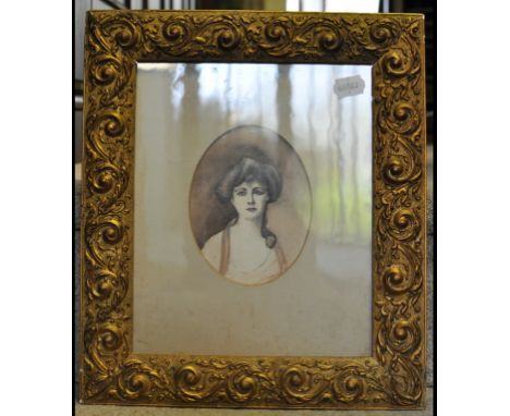
Seven various antique engravings depicting topographical views, including Nerbudda by J Shury, Our Coffee Shop by R M Bryson for Day & Son after Captain G F Atkinson, other similar, together with a photographic sepia portrait print of an Edwardian lady, an antique map of Calcutta, and a signed portrait painting of a dog, all framed (10).


Lot 1155
Atkyns (Sir Robert) The Ancient and Present State of Glocestershire, T Spilsbury for W Herbert, 1768, second edition, title page with woodcut printer's device, Author's Epitaph, eight single page engraved coats-of-arms, double page folding map of Gloucestershire, double page folding plan Gloster City, double page folding engraving West Prospect of Gloster, double page folding engraving Gloster Cathedral, sixty-one double page engraved bird's eye views drawn and engraved by Johannes Kip; brown leather covered boards, flat spine with gilt tooling and lettering, bears armorial bookplate


Lot 2732
1987-1999 AD. Obv: map of Europe and stars with euro '€' symbol below. Rev: crown over oak spray with 1 to left and FR to right with archangel St Michael head privy and Romain Coenen (mintmaster, 1987-2009) scales marks below. Edge: plain. 12.03 grams, 30mm. An early pattern towards euro coinage. [No Reserve] Near as struck; some marks. Rare.


Lot 677
A brass plate incised with a birds eye view map of Berkeley, with box containing text reading - Berkeley in 1327 by Order of Queen Isobel, Sir John Maltravers & Sir Thomas Gurney Did Fowly Put To Death King Edward II at Berkeley Castle, He was 43, the overall plate measuring 30 x 46 cm approx (presented in landscape)


Lot 483
A mixed lot of prints to include "An Evening on the South Downs" after Edwin Douglas, etched by C. O. Murray; a 19th Century coloured lithograph of a peasant mending a coat in a hovel; an aquatint of Kings College Chapel, Cambridge; Baxter prints, messages to and from Australia; a coloured county map of Suffolk engraved for moules English counties; a late 19th Century oil on board signed A. Wright and two Russell Flint coloured prints etc.

Lot 525
An Edwardian chromolithograph stipple print of riders in 17th Century dress, an etching with aquatint of a Venetian canal 40/70 signed Vgo Baracco watercolour landscape indistinctly signed, dated October 85, The School Cloister Oundle, limited edition colour print 774/1000, signed in pencil Jane Carpanini and a framed Ordnance Survey map of Tudeley Kent (5).


Lot 246
Thirteen WW2 Luftwaffe Multisigned cover RAF Escape from Libya cover. Rare Hans Rossbach variety, a very limited edition numbered 21 of 124. Signed by the Luftwaffe JG27 Glorious Dozen THIRTEEN Luftwaffe pilots, Adolf Galland, Eduard Nuemann, Gustav Rodel, Ernst Borgen, Ernst Dullberg, Ludwig Franzisket, Hans-Joachim Heinecke, Werner Schroer, Ferdinand Vogel, Emil Clade, Karl-Heinz Bendert, Friedrich Korner, and Horst Reuter. Also signed by Bernhard Woldenga the senior Kommodore of JG27 who commanded the unit from June 1941 to June 1942 in the Western Desert. All of the signatories (except Korner & Reuter) participated in the Battle of Britain. This cover is certified and then signed to reverse by Hans Rossbach. Cover comes with loads of information, photos, signature map and correspondence from Rossbach. Numbered 21 of 124, signed and certified on the reverse. Good condition. All signed items come with Certificate of Authenticity. Can be shipped worldwide.
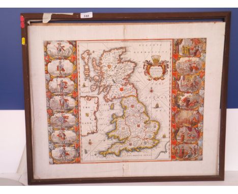
Lot 188
AFTER JOHANNES BLAEU "Britannia Anglo Saxonum Heptarchia", map, black and white engraving, later coloured CONDITION REPORTS Size of the printed image approx 52.5cm x 42cm, total size approx 62 x 52cm. Print is sealed within the frame so unable to check whether or not it is stuck down / laid down. However, the appearance through the glass is fairly flat so it is possible that it may be stuck down. Repaired vertical tears at and near centre fold. Some general wear, dirt and rust type spots. Bears a faded brown ink inscription / number bottom right which appears to read "55". Some smudges and splashes of the red colouring to the map. The board to the back of the frame is stamped "Galerie Ray ..........". The map is believed to be a 17th Century print. NB Print has now been removed from frame, and we can confirm that it is stuck down throughout straight onto brown board, and the edges have been trimmed to the size of the board.
Lot 33
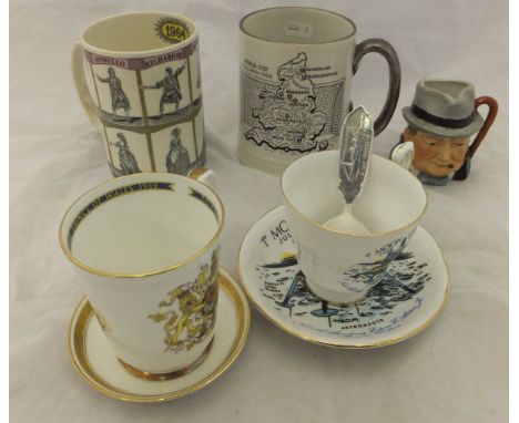
A Hornsea mug marked "Postal Union Congress London 1929", together with a Wedgwood of Etruria mug depicting Shakespeare's plays (400th Anniversary), a Britannia Designs mug for The World Cup England 1966 featuring a map of the stadiums, a Paragon cup and saucer commemorating The First Moon Landing July 1969, a caddy spoon embossed with the HMS Venus ship, an Aynsley cup with Royal Coat of Arms, a Cooper Clayton character jug and a Minton bone china pin dish commemorating The Crowning of Queen Elizabeth II


Lot 93
A NAVIGATORS MAP & LOG FOR A RAID IN MARCH 1945. A 33" x 30" Navigators Map with route and destination clearly marked, dated 15th/16th March 1945. It was recorded for the raid by 107 Squadron Lancasters on Nuremberg, having taken off from Hemswell. A Mark 111 Lancaster number ME 496 Squadron Code TC & K. Flown by a different crew the following night on a similar raid, the same aircraft was shotdown by night fighters, near Furth. Only three of the crew survived, having safely parachuted to become Prisoners of War.

Lot 323
Great Britain1883 (10 Oct.) printed advertising envelope for the London agency of the southern pacific railroad of texas and california addressed to Interlaken, bearing 1880 2½d blue plate 22, 1881 1d lilac (2) and 1880 ½d deep green, stamps variously defective with ink stains and ½d severed, reverse with a printed map of the southern pacific railroad, from new orleans to san francisco. Subject to 20% VAT on Buyer’s Premium. For more information please view Terms and Conditions for Buyers.


Lot 1359
A George V hallmarked silver three piece cruet in the form of trophy cups, with glass liners, TH Hazlewood, Birmingham 1918, and three Victorian hallmarked silver napkin rings with bright cut foliate decoration, John Henry Potter, Sheffield 1895, combined approx 5.49ozt, plus a pair of silver plated napkin rings decorated with a map of Cyprus (8).


Lot 187
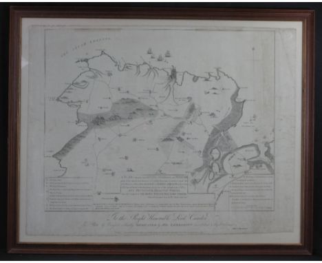
THOMAS PROBERT (land surveyor), published by Boyer, Faden Carey and Wilkinson, 'A plan of the part of the County of Pembroke called Pen-caer and the sea coast adjacent, where between 1200 and 1400 French troops under the command of General Tate made a descent on a point of land called Garn or Cerrig Gwastad on the 22nd day of February 1797, and the place of their encampment, also the place of their surrender on the 24th ditto to his Britanick Majesty's forces under the command of the right honourable Lord Cawdor.' An uncoloured map published 1798. 66 x 77cm approximately. CONDITION REPORT: Creased with marks and stains but basically in good condition commensurate with age. Now in modern glazed frame.

Lot 188
BAPTISTE HOMANNO, 'Insulae A Principartus Rugiae', sparsely coloured. 49 x 58cm and a map of the China Sea (Mers de Chine) from 'The Atlas du Voyage de la Perouse', sparsely coloured, 51 x 69cm approx. (2) CONDITION REPORT: Both have minor foxing spots and discolouring but are basically good.

Lot 190
GERALD MERCATOR, (1607-1633), 'Cornubia, Devonia, Somersetus, Dorchestria, Wiltonia, Gloucestria, Monumetha, Glammorgan, Caermarden, Pembrok, Cardigan, Radnor, Brecnoke, Herefordia and Wigornia.', [sic], a map of the South West of England and South Wales, coloured. 37.5 x 46.5cm approx. CONDITION REPORT: Good condition overall only very minor discolouring, visible plate mark. Framed and glazed.


Lot 447
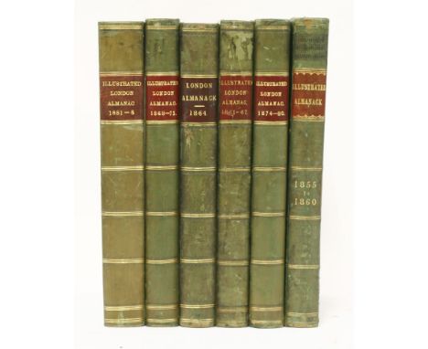
1. The Illustrated London Almanack: Six volumes: 1855-60; 1861-67; 1868-73; 1874-80; 1881-88; and 1864-71. Bound without general title, but all the coloured chromolithograph plates present. 4to.; half leather. VG; 2. Robinson, P F: History of Hatfield House. For author, Arch, 1833. Complete with engraved dedication leaf, vignette, seven plates, and two plans. Folio, half leather. Rebacked; occasional foxing; 3. Great Northern Railway Distance Map, 1897. Large folding linen backed map in original leather covers. G+ (8)


-
109182 item(s)/page