We found 109182 price guide item(s) matching your search
There are 109182 lots that match your search criteria. Subscribe now to get instant access to the full price guide service.
Click here to subscribe- List
- Grid
-
109182 item(s)/page

Lot 608
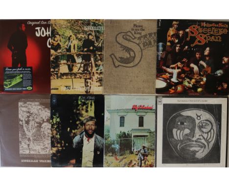
FOLK-ROCK - LPs. A collection of approx. 85 LPs, artists/titles to include: Johnny Cash - Original Sun Singles '55 - 58', Steeleye Span - Please To See The King (original 1st UK pressing, textured sleeve), Hark! The Village Wait, Below The Salt, Muckram Wakes - A Map Of Derbyshire, Taj Mahal - Happy To Just Be Like I Am, Taj Mahal, The Natch'l Blues, Giant Step, Leonard Cohen - Songs From A Room, Nitty Gritty Dirt Band, Francoise Hardy, Ry Cooper, Johnny Cash, Richard and Linda Thompson, Whippersnapper, Bob Dylan, Stevie Nicks, Runrig, Joni Mitchell, The Cluster Of Nuts Band, Allan Taylor. Condition gen. VG - EX.

Lot 111
TAIWAN TRAY. A South East Asian silver coloured metal tray in the shape of the island of Taiwan. The front engraved with the island of Taiwan & showing the outline of China & other nearby islands. To the reverse, an engraved outline map of the United Kingdom & neighbouring countries. Stamped twice with seal marks. Length approx. 33.5cm. Approx. 12½oz.

Lot 390
A MAP (French) teddy bear 1950-1955, With short dark brown synthetic plush, clear and black glass eyes, pronounced muzzle, black velvet nose, black stitched mouth, swivel head, broad shoulders, jointed limbs with beige plush pads, hump and inoperative squeaker —22in. (56cm.) high - see foot note for lot TD104, this actual bear appears on page of 69 of Eric Petit’s book on FADAP - this bear is known as Peyraubé

Lot 393
A rare MAP (French) white shaggy mohair teddy bear 1935, With clear and black glass eyes with remains of brown painted backs, brown stitched nose and mouth, swivel head, broad shoulders, jointed limbs with felt pads and inoperative squeaker —22in. (56cm.) high (damage to left foot pads) - this bear is known as Dounegal


Lot 529
John Speed (1552-1629) - Two engravings - Map of "The County of Nottingham described the Shire, Towns, Situation, and the Earls thereof Observed", showing six armorials of the Earls of Nottingham, published by John Sudbury and George Humble 1611/1614, 20ins x 15.25ins, and map of "Leicester both County and City described" 20ins x 15ins, both unframed


Lot 251
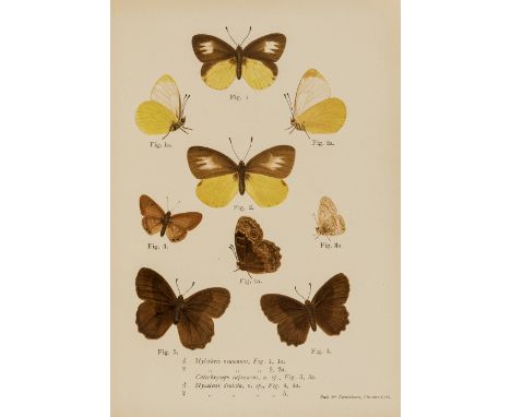
A POLISHED WOOD STORE BOX BEARING "WATKINS & DONCASTER" TRADE LABEL, housing a collection of striking "Temperature Forced" abberations - Nymphalidae Small Tortoiseshell ab. pseudo-Connexa. ab. semi-chnusoides, Painted Lady ab. priameis., ab. varina. J.H. Payne Lincoln Collection, 1970'S full data. Series of Extreme Aberration Map Butterfly (A. levana) Queen of Spain Fritillary, Tingewick, Bucks X.09, K. Bailey Small Tortoiseshell aberration, (Black Pin), Wilts., July '72, R.E.S. (Roy Stockley). 32 Specimens


Lot 107
Africa.- Big Game.- Neumann (Arthur H.) Elephant-Hunting in East Equatorial Africa, first edition, half-title, frontispiece, chromolithographed plate of butterflies, illustrations, many full-page, folding colour map in pocket at end, pencil inscription to half-title, ink signature to frontispiece verso, some small marginal tears, mostly repaired, zebra print endpapers, original pictorial cloth, a little spotted, chipping to spine extremities with some loss, [Czech p.122], 1898; and another, similar, 8vo (2)
Lot 114
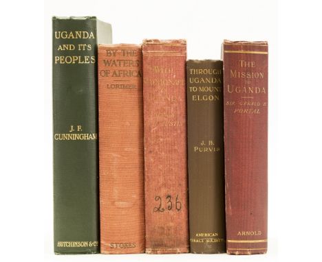
NO RESERVE Africa.- Portal (Sir Gerald) The British Mission to Uganda in 1893, first edition, half-title, frontispiece, folding-map, illustrations, 32pp. advertisements at end, ink inscription, original cloth, a little rubbed, [Czech pp.132-133], 1894 § Austin (Major Herbert H.) With Macdonald in Uganda, first edition, frontispiece, plates, folding colour map (tear to foldline), 32pp. advertisements at end, occasional spotting, ink name-stamp to half-title, front free endpaper pasted down, ex-library with usual stamps, original cloth, rubbed and worn, ink number to spine foot, [Czech p.8], 1903 § Cunningham (J. F.) Uganda and its Peoples, first edition, frontispiece, illustrations, cracked upper hinge, original decorative cloth, a little rubbed, 1905; and 2 others, similar, 8vo (5)
Lot 122
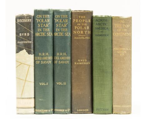
NO RESERVE Polar.- Amedo of Savoy (Luigi) On the "Polar Star" in the Arctic Sea, 2 vol., first English edition, frontispieces, plates, 2 folding, illustrations, 5 maps, 2 folding, 1 with marginal loss, original decorative cloth, a little rubbed, 1903 § Rasmussen (Knud) The People of the Polar North: a Record, first English edition, frontispiece, plates, folding map, occasional spotting, original cloth, a little rubbed, 1908 § Cook (Frederick A.) To the Top of the Continent, frontispiece, plates and illustrations, occasional spotting, ink inscription, original decorative cloth, 1909; and 2 others, similar, 8vo (6)
Lot 115
NO RESERVE Africa.- Speke (John Hanning) Journal of the Discovery of the Source of the Nile, first edition, engraved portrait frontispiece, plates and illustrations, 1 map only (of 2), occasional marginal damp-staining, scattered spotting, some edges neatly strengthened, contemporary half calf, rubbed, small splits to spine head, [Czech p.151], 1863 § Swayne (George C.) Lake Victoria. a Narrative of Explorations in search of the Source of the Nile, frontispiece, plates and illustrations, ink inscription inside upper cover, original cloth, a little rubbed, small loss to spine head, William Blackwood and Sons, n.d., 8vo (2)
![Lake District.- Letter in verse to Walter Cowperthwaite, parish-clerk of Cartmel, 1p., folio, n.p., n.d. [c. 1760s], complain](https://cdn.globalauctionplatform.com/36162f3c-2fe9-4ef2-8ebd-a99800cf71a6/5c4f6c0f-0c8b-4937-a794-a99800d3b798/468x382.jpg)
Lot 27
Lake District.- Letter in verse to Walter Cowperthwaite, parish-clerk of Cartmel, 1p., folio, n.p., n.d. [c. 1760s], complaining that the new priest will not cross the beck in Cartmel to give services at the writer's local church, tear along first line slightly obscuring text, folds, browned; and a small quantity of ephemera, including a pen and ink map of Piel Castle, or as titled here as the Pile of Fouldray, v.s., v.d. (sm. qty).
Lot 123
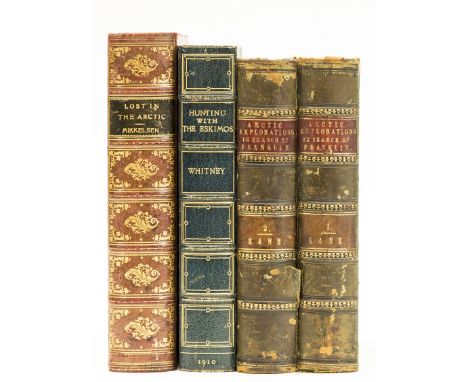
NO RESERVE Polar.- Kane (Elisha Kent) Arctic Explorations: the Second Grinnell Expedition in Search of Sir John Franklin, 2 vol., first edition, engraved portrait frontispieces, additional vignette titles, 2 maps only (of 3), 1 folding, 18 plates, illustrations, spotting, contemporary half-calf, rubbed, small split to spine, Philadelphia, 1856 § Whitney (Harry) Hunting with Eskimos, frontispiece, plates, folding map, bookplate, later half-morocco, a little rubbed, 1910 § Mikkelsen (Ejnar) Lost in the Arctic, first edition, frontispiece, plates, folding map at end, bookplate, contemporary calf, gilt, 1913; 8vo (4)

Lot 108
NO RESERVE Africa.- Boyes (Maj. John) John Boyes King of the Wa-Kikuyu, 11 plates, 1 loose, 1 map, spotting, cracked hinges, 31pp. publisher's advertisements at end, slight bumping to spine extremities, 1911; The Company of Adventurers, plates, a little rubbed, 1928, first editions, frontispieces, original cloth, [Czech p.21], 8vo (2).
Lot 130
NO RESERVE Birds.- Africa.- Jackson (Sir Frederick John) The Birds of Kenya Colony and the Uganda Protectorate, 3 vol., first edition, portrait frontispiece, 24 colour plates, captioned tissue-guards, illustrations, folding colour map, 4pp. advertisements at end, faint spotting to endpapers, original buckram, rubbed, slight bumping to corners and extremities, 1938; Notes on the Game Birds of Kenya and Uganda, first edition, colour frontispiece, 12 colour plates, cracked hinges, ex-library with label pasted inside lower cover, original cloth, rubbed, 1926; and another by the same, 8vo (5)
Lot 113
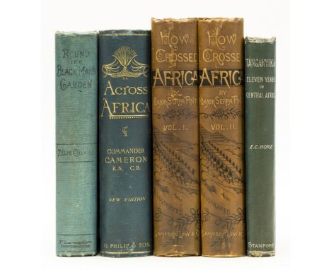
Africa.- Pinto (Major Serpa) How I Crossed Africa, 2 vol., first edition, plates, illustrations, maps including large folding map in pocket at end, cracked hinges, original pictorial cloth, a little rubbed, [Hosken p.160], 1881 § Hore (Edward Coode) Tanganyika: Eleven Years in Central Africa, first edition, A.L.s from author tipped-in at end, folding frontispiece, full-page illustrations, part obituary of author pasted inside lower cover, original decorative cloth, a little rubbed, 1892; and 2 others, Africa, 8vo (5)

Lot 121
Oceania.- Guppy (H. B.) The Solomon Islands and Their Natives, plates, 1887; The Solomon Islands: their Geology, General Features and Suitability for Colonization, maps, 1887, first editions, colour map frontispieces, cracked hinges, bookplate, original cloth, gilt, a little rubbed, slight bumping to corners and extremities, 8vo (2)

Lot 386
RITCHIE HENRY: (1876-1958) Henry Peel Ritchie. British Royal Navy Captain. Ritchie received the first Victoria Cross awarded to naval personnel during the First World War for his courageous actions in November 1914, which left him seriously wounded. Attractive signed colour printed oblong 9.5 x 5.5 card `H. Peel. Ritchie´, being a printed drawn map entitled `Local Circuit´. The map shows the « Spare » and « Main » Using Gun Branch Box. Boldly signed by Ritchie to the lower white border. The card has been lightly affiched to a larger folio, easily removable. VG £100-150 The Victoria Cross is the highest and most prestigious award for valor that can be given to members of the British armed forces.
![[JAPAN]: Unusual drawn and written attractive document, being a Japanese city map [C.19th century] with lengthy carefully wri](https://cdn.globalauctionplatform.com/6e213d9a-c4f6-4d70-959a-a98400d83e70/5e6f0dcc-006d-43a7-8209-a98400e11f23/468x382.jpg)
Lot 625
[JAPAN]: Unusual drawn and written attractive document, being a Japanese city map [C.19th century] with lengthy carefully written information. Large foldable city map of Osaka-Kyoto, small 8vo when folded, 31 x 11.5 fully opened, fully drawn and written to recto and verso, partially coloured, in Japanese. The written text details the rickshaw prices in this area. Overall age wear, cover partially loose. F £500-800


Lot 388
Great Western Railway Interest - G.W.R. folding District Map, 1886, 6 miles to one inch, 116cm x 152cm, together with a G.W.R. book of distance tables, published by Railway Clearing House 1924, red cloth bound and a G.W.R. Telegraph 'Line Clear' book 1882-1883 (3) Condition: Please see extra images and TELEPHONE department if you require further information

Lot 290
Early 19th Century 1¼ inch miniature pocket globe contained in a mahogany case with domed cover, 5.5cm high Condition: We would advise viewing this lot in person, the sections of the globe have opened on the joints leaving at least eight joints showing, one section has a crack across this section, rubbing to the map, light wear to case - **General condition consistent with age

Lot 346
Johannes Blaeu - 17th Century hand coloured engraved map - Northamptonshire, Comitatus Northantonensis vernacule Northamton Shire, published Amsterdam circa 1650, 40cm x 49.5cm Condition: The map is currently framed but judging from the rippling to the surface we can assume it is not laid down, some discolouration - **General condition consistent with age
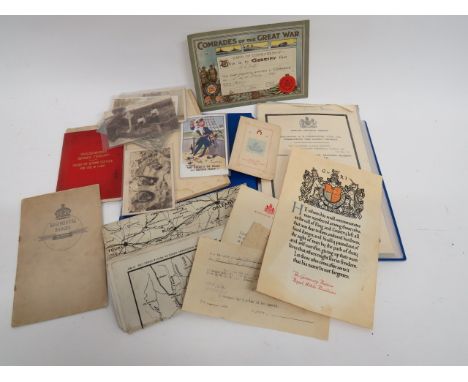
Lot 317
Selection of Various Military Paperwork and Photographsincluding WW1 memorial scroll to 'Pte Goronwy Davies Royal Welch Fusiliers' ... Comrades of the Great War certificate ... Selection of military orders for the funeral of King Edward VII 20 May 1910 ... Worcestershire Imperial Yeomanry Order Of Divine Service booklet ... Small selection of WW1 postcards ... WW2 map poster. Quantity.44781 Pte Goronwy Davies 19th Batt RWF. Died 25/11/1917. Buried Ontario Cem Sains-Les-Marquion, France#<$$


Lot 525
Small Selection of Various Itemsincluding a good series of aircraft photos taken on board HMS Courageous in 1938 showing Swordfish crashing on board and into the sea (23) ... Post war navigation silk map covering some of the Baltic ... Small selection of books including Advanced Flying Training ... Inns of Court Rifle Volunteers 1896 ... 51st Battalion The Gordon Highlanders 1914-1920 ... Kings Royal Rifle Corps 1912.

-
109182 item(s)/page