

Phillips (John). Illustrations of the Geology of Yorkshire; or, a Description of the Strata and Organic Remains of the Yorkshire Coast [-Part II. The Mountain Limestone District], 1st editions, York: for the author [-London: John Murray], 1829-36. 2 parts in 1 volume, 4to (279 x 215 mm), later half morocco, top edge gilt, xvi 192, xx 253 pp., part 1 with hand-coloured lithographical geological map, 9 lithographic geological cross-sections (all but one hand-coloured), 15 lithographic plates (numbered 1-14, including 1 bis), part 2 with 24 engraved plates (variably spotted; one folding), engraved folding map,Mantell (Gideon Algernon). A Pictorial Atlas of Fossil Remains, 1st edition, London: H. G. Bohn, 1850. 4to, original cloth, pp. 207, hand-coloured lithographic frontispiece, 74 engraved or lithographic plates, bookplates, fraying to joints and spine-ends, inner hinges loose, occasional light offsetting,Crouch (Edmund A.). An Illustrated Introduction to Lamarck's Conchology, 1st edition, London: Longman [etc.], 1826. 4to (314 x 240 mm), contemporary half calf, iv 47 pp., 22 hand-coloured lithographic plates, errata slip, bookplate, covers detached,Murchison (Sir Roderick Impey). Siluria. The History of the Oldest Known Rocks containing Organic Remains, 1st edition, London: John Murray, 1854. 8vo (214 x 138 mm), later quarter calf, pp. xvi 523, 37 lithographic plates with caption-leaves, 2 folding maps, (plates occasionally spotted or damp-stained),Ramsay (Andrew C.). Geological Map of England and Wales, 3rd edition, London: Edward Stanford, 1873. Hand-coloured lithographic map, sectionalised and laid on linen, 990 x 755 mm, light damp-staining to foot, slipcase (qty: 5)Footnote: Ward & Carozzi 1757-8 (Phillips), 1490 (Mantell), 558 (Crouch), 1627 (Murchison).Phillips's work is inscribed 'G. W. Wood, from the author' on a slip mounted to the initial blank; on the second blank is the ownership inscription 'Geo. W. Wood, Singleton Lodge'. This appears to be George William Wood (1781-1843), Manchester businessman and MP for Kendal. In part II (p. xiii) Phillips writes 'In 1830, I saw again, in company with Mr. G. Wood, the limestone tracts of Namur and Luxemburg [...]'. Bound in at the rear is an article by Phillips, 'On a Group of Slate Rocks ranging E.S.E. between the rivers Lune and Wharfe, from near Kirby Lonsdale to near Malham; and on the attendant Phaenomena', c.1828 (18 pp. with folding plate and hand-coloured geological map).
We found 109182 price guide item(s) matching your search
There are 109182 lots that match your search criteria. Subscribe now to get instant access to the full price guide service.
Click here to subscribe- List
- Grid
-
109182 item(s)/page
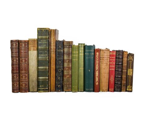
Richardson (Joseph). Furness Past and Present: its History and Antiquities, 1st edition, Barrow-in-Furness: J. Richardson, 1880. 2 volumes, 4to, original red morocco gilt, all edges gilt, engraved frontispiece and chromolithographic dedication leaf to each volume, chromolithographic title-page to volume 1 (none apparently issued for volume 2; wording in list ambiguous), 2 maps, 68 plates (mainly dual-tint lithographic views, also including 5 plates of coats of arms heightened in gold and silver; many folding), spotting towards front, Rimmer (Alfred). Rambles round Eton and Harrow, 1st edition, deluxe issue, number 193 of 250 copies only, London: Chatto and Windus, 1882. 4to, original quarter japon (rubbed and darkened), wood-engraved plates and vignettes on india paper, mounted, laid-in manuscript note reading 'Mrs Wordsworth, with very kind regards and pleasant memories of days at Eton, and in the Lake District, from W. E. Buckley, June 5 1883',Housman (John). A Descriptive Tour, and Guide to the Lakes, Caves, Mountains, and Other Natural Curiosities, in Cumberland, Westmoreland, Lancashire, and a Part of the West Riding of Yorkshire, 2nd edition, Carlisle: F. Jollie, 1802. 8vo (208 x 122 mm), contemporary half calf (rubbed), engraved folding map, 10 plates (2 folding), toning, a few damp-stains,and 13 others (not collated), including Pye (ed.), The Sportsman's Dictionary, 5th edition, Stockdale, 1807 (4to, with plates), Lysons, Magna Britannia ... Volume the Fourth ... Cumberland, 1st edition, 1816 (plates), The Life and Death of Cormac the Skald, 1st edition, Ulverston, 1902, and similar (qty: 17)
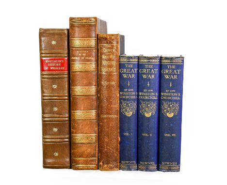
Whitaker (Thomas Dunham). An History of the Original Parish of Whalley, and Honor of Clitheroe, in the Counties of Lancaster and York. The Second Edition, with Additions, London: J. Nichols and Son, 1806. 4to (288 x 228 mm), contemporary diced russia gilt, rebacked, gilt edges, engraved portrait frontispiece, folding map, 27 plates (views and portraits, several folding), 11 folding pedigrees, offsetting, short closed tear to map,ibid. The History and Antiquities of the Deanery of Craven, in the County of York. The Second Edition, with many Additions, Corrections, Map, and Views of Gentlemane's Seats, Antiquities, London: J. Nichols and Son, 1812. 4to (310 x 230 mm), near-contemporary half russia gilt, all engraved and sepia aquatint plates as called for (including one plate 'Autographs of the prior and canons of Bolton' facing p. 415, not listed),and 2 others including Speight, The Craven and North-West Yorkshire Highlands, 1st edition, 1892 (4to, original half roan, front inner hinge loose) (qty: 6)

Whitaker (Thomas Dunham). The History and Antiquities of the Deanery of Craven, 3rd edition, Leeds: Joseph Dodgson, 1878. Folio, original brown morocco over bevelled boards, all plates and folding pedigrees as called for (mainly aquatint views), binding rubbed, marginal tide-mark to frontispiece, closed tear in pedigree at p. 515,Mortimer (J. R.). Forty Years' Researches in British and Saxon Burial Mounds of East Yorkshire, 1st edition, London: A. Brown & Sons, 1905. Folio, original quarter morocco, colour frontispiece, folding map, 125 plates,Collyer (Robert, & J. Horsfall Turner). Ilkley: Ancient and Modern, 1st edition, Otley: Wm. Walker & Sons, 1885. 4to, original cloth, all plates as called for, geological map, pale marks to rear cover,and 9 others, Yorkshire reference, 19th and early-20th century (not collated), including Joseph Lucas, Studies in Nidderdale, 1st edition, [1882], Henry Trail Simpson, Archaeological Adelensis, 1st edition, 1879, W. Wilberforce Morrell, The History and Antiquities of Selby, 1st edition, 1867, and similar (qty: 12)
![Allouse (Bashir E.). Birds of Iraq [Arabic title: al-Tuyur al-'Iraqiyah], 1st edition, Baghdad: Ar-Rabitta Press, 1960-2. 3 v](https://cdn.globalauctionplatform.com/db4af7a9-7339-4127-83a8-ad8a00c5b912/15d91ee3-013d-45ee-920f-ade90102ce35/468x382.jpg)
Allouse (Bashir E.). Birds of Iraq [Arabic title: al-Tuyur al-'Iraqiyah], 1st edition, Baghdad: Ar-Rabitta Press, 1960-2. 3 volumes in 1, 8vo (234 x 168 mm), modern cloth, text in Arabic and English, original wrappers bound in,Moore (H. J., & C. Boswell). Field Observations on the Birds of Iraq [Arabic title: Mulahadhat haqliyah 'an al-tuyur fi'l-'Iraq], 1st edition, Baghdad: Ar-Rabita [sic] Press, 1956-7. 3 volumes in 1, 8vo (234 x 160 mm), modern cloth, text in Arabic and English, lithographic folding map, original wrappers bound in, laid-in typed letter signed from Moore (addressed to 'Kenneth'; Eric Hosking's annotations verso),Nicoll (M. J.). Handlist of the Birds of Egypt, 1st edition, Cairo: Government Press, 1919. 8vo, original cloth-backed printed boards, half-title, folding map, 12 halftone plates (numbered 1-23: all but the last printed and numbered on both sides), 8 colour plates, inscribed 'with the author's kind regards' on front board, extremities bumped,and 4 other works (Millais, Newfoundland and its Untrodden Ways, 1st edition, 1907, Far Away up the Nile, 1st edition, 1924, spine sunned; Bannerman, The Canary Islands, 1st edition, 1922; Verner, My Life among the Wild Birds in Spain, 1st edition, 1909; all in original cloth with all plates and maps as called for, bookplates of Eric Hosking) (qty: 7)THE LIBRARY, PICTURES & CAMERA COLLECTION OF ERIC HOSKING OBE HON. FRPS FBIPP (1909-1991)Footnote: Library Hub traces two copies only of Field Observations (Natural History Museum and Oxford).

Bannerman (David A.). The Birds of Tropical West Africa, with Special Reference to those of the Gambia, Sierra Leone, the Gold Coast and Nigeria, 1st edition, London: Crown Agents for the Colonies, 1930-51. 8 volumes, 4to, original dark blue cloth, 86 chromolithographic and other mainly colour plates after Henry Jones, Henrik Grönvold, G. E. Lodge and others, 7 maps (5 folding), volume 3 spine faded,Priest (Cecil D.). The Birds of Southern Rhodesia, 1st edition, London: William Clowes and Sons, Limited, 1933-6. 4 volumes, 4to, original dark blue cloth, 40 colour maps, folding map, the set largely unopened, spines sunned, covers marked, half-titles spotted, very light damp-staining to top margins of volume 4,Jackson (Sir Frederick John). The Birds of Kenya Colony and the Uganda Protectorate. Completed and Edited by W. L. Sclater, 1st edition, London: Gurney and Jackson, 1938. 3 volumes, 4to, original black cloth, halftone frontispiece, 24 colour plates, folding map, abrasion to volume 2 spine, each work with bookplate of Eric Hosking (qty: 15)THE LIBRARY, PICTURES & CAMERA COLLECTION OF ERIC HOSKING OBE HON. FRPS FBIPP (1909-1991)

British Isles. Collection of 17 engraved maps of the British Isles by various cartographers, 17th-early 19th century, including:1) Blaeu (Johannes). Mona [Isle of Man], Amsterdam, [1645 or later]. Leaf size 550 x 305 mm, contemporary hand-colouring, retaining integral text-leaf (text in German), 2) ibid. Mervinia; et Montgomeria comitatus, Amsterdam, [1645 or later]. 500 x 610 mm, French text verso, hand-coloured, central fold with split at each end extending into image,3) Speed (John). The Countie and Citie of Lyncolne, London: Thomas Basset and Richard Chiswell, [1676]. 408 x 520 mm, hand-coloured, slightly browned, crinkled along central fold, restoration to border at lower left corner,4) ibid. Breknoke, both Shyre and Towne, London: Henry Overton, 1743. 422 x 540 mm, hand-coloured, adhesive staining to margins,5) Ogilby (John). The Road from Carlisle to Barwick, London, c.1676. 485 x 425 mm, with relevant text-leaf,6) Saxton (Christopher). Dunelmensis episcopatus, Wilhelmus Kip Sculpsit, London, [1607 or later]. 335 x 390 mm, hand-coloured,and 11 others, including maps of the entire British Isles by Zatta (1776), Janvier (c.1780), Robert (1787), Homann (c.1730, splits to central fold), and Sayer (1788), all hand-coloured in outline, Seale, A Correct Chart of St George's Channel and the Irish Sea (c.1743), Cary, A Map of Middlesex (1805), and 4 other city plans or views (qty: 17)

Grimble (Augustus). Deer-Stalking and the Deer Forests of Scotland, 1st collected edition, London: Kegan Paul, Trench, Trübner & Co., Ltd., 1901. 4to, original quarter vellum, 26 halftone or photogravure plates by Thorburn and others, bookplate of Eric Hosking, covers slightly marked,Maxwell (Marius). Stalking Big Game with a Camera in Equatorial Africa, 1st trade edition, London: William Heinemann, 1925. Royal 4to, original blue cloth, dust jacket (loss to head of spine-panel, slightly dust-soiled overall, a few nicks), all halftone photographic plates as called for (including 3 folding panoramas), bookplate of Eric Hosking,Kearton (Cherry, & James Barnes). Through Central Africa from East to West, 1st edition, London: Cassell and Company, Ltd, 1915. 4to, original blue pictorial cloth, top edge dyed blue, folding map, all plates as called for (halftones and photogravures), bookplate of Eric Hosking, spine rolled, occasional spotting to text-block,Schillings (Carl Georg). With Flashlight and Rifle. A Record of Hunting Adventures and of Studies in Wild Life in Equatorial East Africa, 1st edition in English, London: Hutchinson and Co., 1906. 2 volumes, 8vo, original green cloth, elephant roundels to front covers, halftone photographic illustrations throughout, endpapers spotted, inner hinges cracked (text-blocks heavy), volume 2 front free endpaper removed, and 9 other works, mainly big-game hunting and African ornithology, original cloth (qty: 14)THE LIBRARY, PICTURES & CAMERA COLLECTION OF ERIC HOSKING OBE HON. FRPS FBIPP (1909-1991)

British Isles. Collection of engraved maps, 18th-19th century, all sectionalised and laid on linen, with contemporary hand-colour, titles comprising: 1) South Britain, or England and Wales ... by Thomas Kitchin, London: Robert Sayer & John Bennett, 1777. approx. 1300 x 1100 mm, in 32 sections, with large decorative cartouche, toned overall,2) A General Map of England & Wales divided into its Counties ... by Thomas Kitchin, London: printed for the author, 1767. 640 x 545 mm, decorative cartouche, with contemporary marbled-paper slipcase,3) A New and Accurate Map of Warwickshire ... by Thomas Kitchin, c.1746. 680 x 525 mm, with inset views and plans, title and dedication each within decorative cartouche, one section partially lifting from linen,4) Bowles's Road Director through England and Wales, London: Bowles & Carver, 1802. 610 x 540 mm, with decorative cartouche, a few stains, holes in linen at intersections of a few folds, with in original marbled-paper slipcase with printed label,5) Map of the County of Middlesex from an Actual Survey made in the Years 1819 & 1820 by C. & I. Greenwood ... corrected to the present period, London: C. Greenwood & Co., 1829. 650 x 770 mm, toning, slight offsetting,6) Map of the South East Circuit of the Principality of Wales ... from an Actual Survey by C. & I. Greenwood, corrected to the present period, London: Greenwood & Co., 1831. 655 x 760 mm, toning, slight offsetting,together with 2 similar maps (including Faden, Spain, 1796), and 3 educational atlases including Thomas Nelson, A Classical Atlas, Edinburgh: Alex Macredie, c.1810 (engraved title-page, 22 maps engraved double-page maps hand-coloured in outline, closed tear in map 8) (qty: 11)

Legge (W. Vincent). A History of the Birds of Ceylon, London: published by the author, 1880. 4to (325 x 250 mm), contemporary black half morocco, spine gilt in compartments, green cloth sides, top edge dyed green, others untrimmed, xlvi 1237 pp. colour-printed wood-engraved map, 33 hand-coloured lithographic plates by J. G. Keulemans (heightened in gum arabic), wood-engraved key plate, chromolithographic oological plate, bookplate of Eric Hosking, closed marginal tear to foot of 2U3, a few trivial spots to text (qty: 1)THE LIBRARY, PICTURES & CAMERA COLLECTION OF ERIC HOSKING OBE HON. FRPS FBIPP (1909-1991)Footnote: Anker 284 ('A complete and important monograph'); Zimmer pp. 382-3 ('The hand-coloured plates are very fine').Legge 'was commissioned in the Royal Artillery in 1862 and served with the imperial troops in Melbourne in 1867-68. He was then stationed in Ceylon where he pursued his studies of natural history, to which he had long been devoted. As secretary of the Royal Asiatic Society he reorganized the dilapidated museum at Colombo. He also continued the ornithological work begun by Edgar Layard and made an immense collection of birds. He left Ceylon in 1877 ... Legge was a fellow of the Geographical Society and a member of the Zoological Society of London, the Linnean Society and the British and American Ornithologists' Unions and a founder and president of the Australasian Ornithologists' Union' (ADB).
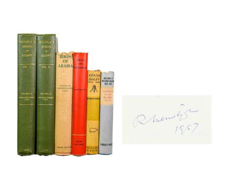
Meinertzhagen (Richard). Nicoll's Birds of Egypt; Birds of Arabia; Kenya Diary 1902-1906; Pirates and Predators, the Piratical and Predatory Habits of Birds; Middle East Diary 1917-1956, 5 works, 1st editions, London: [various publishers], 1930-59. 4to or 8vo, all in original cloth, all except Nicoll's Birds of Egypt with the dust jackets, all plates and maps as called for (including the folding map in end-pocket of Birds of Arabia), bookplates of Eric Hosking, Birds of Arabia with Eric Hosking's manuscript list of birds sighted laid in, Nicoll's Birds of Egypt with linen tape-supports to inner hinges, marginal tape-repair to plate facing p. 273, Birds of Arabia dust jacket frayed along top edge, Kenya Diary spine rolled, dust jacket spine-panel nicked, Pirates and Predators dust jacket rear panel nicked and finger-marked, Middle East Diary with variable spotting to edges and dust jacket, jacket with a few minor nicks (qty: 6)THE LIBRARY, PICTURES & CAMERA COLLECTION OF ERIC HOSKING OBE HON. FRPS FBIPP (1909-1991)Footnote: Birds of Arabia and Kenya Diary 1902-1906 each signed and dated by the author ('R Meinertzhagen, 1957') on the verso of the half-title.

Muirhead (George). The Birds of Berwickshire, 1st edition, Edinbugh: David Douglas, 1889-95. 2 volumes, 8vo, original blue cloth, folding map, 10 plates, 2 plans, bindings slightly rubbed, bumped and marked, Saxby (Henry L.). The Birds of Shetland, 1st edition, Edinburgh: Maclachlan and Stewart, 1874. 8vo, original cloth, gilt vignette to front board, 8 tinted lithographic plates including frontispiece, a few bumps and pale marks to bindings, Harting (James Edmund). The Birds of Middlesex, 1st edition, London: John van Voorst, 1866. Large 12mo, original cloth (rubbed, loss to head of spine, wear to foot of rear joint), tinted lithographic frontispiece, laid-in autograph letter signed from the author to D. Best of Strawberry Hill, 1898 (4 pp., on natural history societies near London), ownership inscription effaced from front free endpaper,Coward (Thomas Alfred). The Vertebrate Fauna of Cheshire and Liverpool Bay, 1st edition, London: Witherby & Co., 1910. 2 volumes, 8vo, original cloth, top edges gilt, others untrimmed, all plates as called for, folding map (backed on linen), with laid-in offprint, The Mammalian Fauna of Cheshire. Reprinted from 'The Zoologist' for May-July, 1895, inscribed 'With the writers' compliments' on front wrapper, and 15 others, county and local avifaunas, late-19th and early-20th century, original cloth (not collated), including Nelson, The Birds of Yorkshire, 1st edition, 1907, Macpherson, A Vertebrate Fauna of Lakeland, 1st edition, 1892, Ticehurst, A History of the Birds of Kent, 1st edition, 1909, Bucknill, The Birds of Surrey, 1st edition, 1900, and similar, nearly all items in lot with bookplate of Eric Hosking (qty: 22)THE LIBRARY, PICTURES & CAMERA COLLECTION OF ERIC HOSKING OBE HON. FRPS FBIPP (1909-1991)Footnote: Mullens & Swann pp. 426 (Muirhead), 510-11 (Saxby), 273 (Harting), 152 (Coward).

Camden (William). The Abridgment of Camden's Britannia. With the Maps of the sevrall Shires of England and Wales, London: John Bill, 1626. Oblong 8vo (185 x 138 mm), 19th-century half calf, signatures pi2 a-c4 [A-E]4 F-N4 (initial blank, pi1, discarded), engraved allegorical title-page, engraved map 'A Tipe of England' to b4 v., 51 engraved county maps (each with strapwork title cartouche), woodcut initials and headpieces, 19th-century ownership inscription to binder's blank, loss to marbled paper on covers, variable faint damp-staining to fore margins (slightly stronger in quires H and M-N), a few small worm-trails to top and fore margins not affecting maps or text, a few leaves closely trimmed just shaving c1 signature-mark and catchword, c4 headline (verso), D4 ('Glocester Shire') headline and H2 ('Darby Shire') signature-mark, title-page with small stain to corner of image, fore edge unevenly shaved and small hole to lower margin, H4 ('York Shire') with short nick at foot, a few minor blemishes elsewhere (qty: 1)Footnote: Chubb XLI; ESTC S107395.Rare miniature county atlas. ESTC traces twelve copies in libraries world-wide and it is postulated that only 200 copies were printed. The maps are notable for being the first of the English and Welsh counties to show longitude and latitude.
![Lizars (W. H., publisher). Lizars' Edinburgh Geographical General Atlas, Edinburgh: W. H. Lizars, [1841]. Folio (480 x 300 mm](https://cdn.globalauctionplatform.com/db4af7a9-7339-4127-83a8-ad8a00c5b912/abffd3bf-6d60-48a4-89cb-adcc00fff4a0/468x382.jpg)
Lizars (W. H., publisher). Lizars' Edinburgh Geographical General Atlas, Edinburgh: W. H. Lizars, [1841]. Folio (480 x 300 mm), contemporary black half morocco (date '1841' at foot), 66 engraved hand-coloured double-page maps (of 68: without numbers 10-11, 'England, on two sheets'; no map numbered 32 issued), double-page 'Table of Mountain Chains' sheet including engraved vignette, text/map block detached from binding, title-page creased and nicked, spotting to a few maps (2-3, 24-5, 61), a few with short split at foot of central fold, number 37 also creased, numbers 7-9 and 52 slightly proud and consequently nicked and rumpled along edges (qty: 1)Footnote: Contains two maps showing the short-lived Republic of Texas: 'United States & Texas with all the Railways and Canals' (no. 63), and 'Mexico and Guatimala [sic] with the Republic of Texas' (no. 66).

Vaurie (Charles). Tibet and its Birds, 1st edition, deluxe issue, number 9 of 65 specially-bound copies signed by the author, London: H. F. & G. Witherby Limited, 1972. 4to, original red half morocco by Sangorski and Sutcliffe,Keulemans (Tony, & Jan Coldewey). Feathers to Brush. The Victorian Bird Artist John Gerrard Keulemans 1842-1912, 1st edition, number 275 of 500 copies signed by the authors, Epse, Netherlands: privately published, 1982. 4to, original half morocco, colour plates,Bagshawe (Thomas W.). Notes on the Habits of the Gentoo and Ringed or Antarctic Penguins. Reprinted from Trans. Zool. Soc., Vol. XXIV. Part 3, 1938. 4to, contemporary red quarter morocco, 7 halftone photographic plates, inscribed 'with the author's compliments and sincere thanks, 9.1.39' on p.1, ownership inscription of Julian S. Huxley, loss to head of spine,and 6 other works, all leather-bound (not collated), comprising: Barrett-Hamilton, A History of British Mammals, 1st edition, 1910 (3 volumes); Johnston, British Mammals, 1st edition, 1903 (bookplate of Sir Gilbert Heathcote of Hursley, 8th Baronet); Macpherson, The Home-Life of a Golden Eagle, 2nd edition, 1910; Bickerton, The Home-Life of the Terns, 1st edition, 1912; Woodhouse, The Butterfly Fauna of Ceylon, 2nd edition, 1949; and Dugmore, The Romance of Newfoundland Caribou, 1st edition, 1913 (bookplate of the author, pencilled inscription identified as authorial presentation inscription to the author's wife by a note in another hand; lacking map), most with bookplates of Eric Hosking (qty: 11)THE LIBRARY, PICTURES & CAMERA COLLECTION OF ERIC HOSKING OBE HON. FRPS FBIPP (1909-1991)

Walpole-Bond (John). A History of Sussex Birds, 1st edition, London: H. F. & G. Witherby, 1938. 3 volumes, 4to, original cloth, dust jackets (dust-soiled, tear to volume 3 jacket spine, a few other nicks), 53 colour plates by Philip Rickman, Glegg (William E.). A History of the Birds of Essex, 1st edition, London: H. F. & G. Witherby, 1929. 8vo, original cloth, dust jacket (fraying to head of spine, a few other nicks), 21 halftone photographic plates, folding map, ibid. A History of the Birds of Middlesex, 1st edition, London: H. F. & G. Witherby, 1935. 8vo, original cloth, dust jacket (a few nicks and shallow chips),and 29 others, all 20th-century county or local avifaunas in the dust jackets, including: Bryan L. Sage, A History of the Birds of Hertfordshire, 1st edition, 1959, inscribed by the author 'Bryan Sage, for Eric Hosking, the best of bird photographers'; T. Hedley Bell, The Birds of Cheshire, 1st edition, Altrincham, 1962, inscribed by the author 'With many thanks for your help, T. Hedley Bell'; R. M. Lockley, The Birds of Pembrokeshire, 1st edition, Cardiff, 1949, signed by the author; C. Oakes & E. Battersby, The Birds of East Lancashire, 1st edition, Burnley, 1939; Eric Hardy, The Birds of the Liverpool Area, 1st edition, Arbroath, 1941; W. Walmesly White, Bird Life in Devon, 1st edition, 1931; William H. Payne, The Birds of Suffolk, 2nd edition, Ipswich, 1978, inscribed 'For Eric Hosking, with grateful thanks and all good wishes from the author, December 1978'; Stewart Angus, Sutherland Birds, 1st edition, Golspie, 1983, signed by the author, Desmond Nethersole-Thomson and 3 others; and similar, most with bookplate of Eric Hosking (qty: 34)THE LIBRARY, PICTURES & CAMERA COLLECTION OF ERIC HOSKING OBE HON. FRPS FBIPP (1909-1991)
![Speed (John). Leicester, both Countye and Citie described, London: John Sudbury and George Humble, 1610 [i.e. 1611 or later].](https://cdn.globalauctionplatform.com/db4af7a9-7339-4127-83a8-ad8a00c5b912/4e26000e-616e-4de1-a8d0-adcc01002053/468x382.jpg)
Speed (John). Leicester, both Countye and Citie described, London: John Sudbury and George Humble, 1610 [i.e. 1611 or later]. Hand-coloured engraved map with inset plan of Leicester, English text verso, glazed both sides and framed, aperture 390 x 520 mm, evenly browned, old repairs to head and foot of central fold verso,ibid. The Countie of Nottingham Described, London: Thomas Bassett and Richard Chiswell, [1676]. Hand-coloured engraved map with inset plan of Nottingham, glazed and framed, aperture 410 x 535 mm, somewhat browned, a few faint spots, not examined out of frame (qty: 2)Footnote:Cf. Chubb XXII (Leicester), XVII (Nottingham).


George Philip and Sons Ltd, Dunkirk to Berlin June 1940 to July 1945: Journeys Taken by The Rt. Honble. Winston S Churchill OM CH FRS MP Prime Minister of Great Britain, In Defence of the British Commonwealth and Empire, map print published by The London Geographical Institute, frame size 99cm x 124cm

WW2 Pattern Dispatch Rider's Waterproof Set consisting khaki, rubberised, overleg leggings. Interior with maker's stamp ... Pair of khaki, rubberised trousers complete with braces. Interior maker's stamp dated "1959" ... Green rubberised coat. Large bag pockets with plain flaps (need re-glueing) ... Pair of leatherette gloves ... 1944 dated, webbing map case ... 1940 dated, small pack. All contained in a large khaki canvas and leather holdall. Quantity.

Small Selection of Third Reich Paperwork including 16 x coloured hanging cards showing Luftwaffe raid on Britain May 1940/ various maps of Europe occupied territories ... German invasion map Blatt 29 covering London ... NSDAP certificate ... 10 x Urlauberfahrten (vacation trips) Zur See (by sea)pamphlets, mostly 1938 ... 4 x large, coloured, pre war certificates.


After John Speede (1552-1629), an engraved map with later hand colouring, 'Breknoke Both Shyre And Towne described Ann. Domini 1610', on laid paper, 'An Alphabetical Table of all the Townes' verso, in double-sided glazed frame, 52.5cm x 64cm overall, with two hand coloured engraved maps after Christopher Saxton (1540-1610), 'Brecknoc Comitaus pars olim Silvrum' and 'Monumethensis Comitatus, Quem Olim Incoluebunt Silures', in matching glazed frames, 44.5cm x 49cm and 46cm x 52cm (3)

CORONELLI (VINCENZA MARIA), a hand-coloured engraved map titled 'Isola di Malta, olim Melita Descritta e Dedicata Dal P. Coronelli Cosmografo della Serenissima Republica di Venetia, All'illustrissimo, et eccellentissimo Signore Giorgio Corner, in Venicea1689' [Island of Malta, formerly Melita Described and dedicated by P. Coronelli Cosmographer of the Serenissima Republic of Venetia, To the most illustrious, and most excellent Lord Giorgio Corner, in Venice1689], the map with title cartouche and ornate hand-coloured border depicting the armorial crests of the Knights of Malta, 43cm x 59cm, framed and glazed

ROSSI (GIACOMO GIOVANNI), a hand coloured engraved map titled 'Isola Di Malta, Gozzo Comino E Cominotto cauata dalle piu recenti notitie e da ta in luce da Gio. Giacomo de Rossi dalle sue stampe in Roma alla Pace con Priu del S. Pont l'anno 1686' [Islands of Malta, Gozzo Comino And Cominotto informed by the most recent news and highlighted by Gio. Giacomo de Rossi from his prints in Rome to Peace with Priu. del S. Pont in the year 1686], with lower inset 'Valetta And Its Fortifications' with surrounding key to thirty seven locations, 40.5cm x 54cm, framed and glazed


CHINA - BEIJING MAP DORN (FRANK) A Map and History of Peiping. Presumably a first edition. Large originally (originally) folding colour lithograph map of Peiping. 840 x 740 mm Literature: Pegg, Cartographic Traditions in East Asian Maps pp.54-55. Notes: 1. A highly visual map of Beijing, showing the principal sites and occupations of the inhabitants, within a pictographic border showing Chinese history. The whole map is crowded with amusing vignettes of the life and sights of the city. 2. Compare with a related map together with its booklet sold at Bonham’s London, 2017/03/01, lot 49, for £ 3.125.中国-北京地图(弗兰克)[INTERNET KEYWORDS] CHINA, CHINESE, QING, ANTIQUE, CERAMIC, PORCELAIN, PAINTING, SCROLL, JADE, DYNASTIE, JAPANESE, VIETNAMESECondition Report: Condition report:- Missing its explanatory booklet and original envelope;- Laid on canvas / fabric;- Very nice details including the history of China with numerous nice details such as Cixi Empress, the boxer revolution etc. starting from the upper center part and going to the right side up to the lower central paert;- approximately three tears (upper left), central right part;- folds (because it was originally folded at the time it was produced.IT CAN BE ROLLED AND PUT IN A TUBE FOR SHIPPING


A BOX CONTAINING VARIOUS MILITARY UNIFORM ITEMS TO A MEMBER OF THE ROYAL NAVY SERVING IN WORLD WAR ONE AND OTHER ITEMS, to include WWI Naval white with blue trim Deck shirt, white trousers belt and wrap up sewing kit, together with a 1913 Gunnery Drill Book(2) and a Naval related postcard postmarked 1918 ALL being attributed to Able seaman H.Holton, who served aboard HMS Agamemnon from 1915-1918, His book also states that he served on HMS Excellent in 1918 (shore establishment) the box also contains medium size Union Jack flag, silk style souvenier map of Europe and two ther Military rucksack style bags
BOX CONTAINING MILITARY ITEMS to include large Union Jack flag, selection of plastic bunting style flags, Webbing, cases, Instruction manuals and booklets, a Wooden case, framed photo of RA Officer, Lipton Souvenir Tea Caddy etc & a boxed “De-Beers” Industrial Diamond Division Gold coloured circular medallion with a small diamond set in the centre of the map of Africa, the attached suspender is silver.

EPHEMERA, a Collection of Postcards, Prints, Newspapers a Map and Ceramics. The postcards comprise approx. 550 - 600 early - mid 20th century examples of 'tourist' type cards, 'saucy seaside' cards, topographical, sentimental and transport examples. The prints are by Chris Woodcock and feature Heavy Transport, the newspaper are 20th century commemorative editions, the map is an Operational Navigation Chart published by the Aeronautical Chart and Information Centre, United States Air Force in 1965 and covers Austria, Denmark, Czechoslovakia, Denmark, France, Germany, Luxembourg, Netherlands, Poland, Sweden and the UK, scale 1:1,000,000. The Ceramics comprise 21 tourism thimbles, a Warwickshire Coalfield plate and 4 Royal themed China pin dishes

A BOX CONTAINING AMERICAN CIVIL WAR INTEREST ITEMS to include two replica Civil War bayonets, civil war DVD's(3) replica map, Eagle Desk ornament, three packs of Civil War information game cards (Gettysburg) black leather belt, standing figure on plinth, small box containing patches etc , two Police style truncheons, incorrect wood and weight, Lamaire Fabi Paris binoculars, cigarette cards etc


A Blocksidge's illustrated Dudley almanac diary and directory, 1911; together with a quantity of stereoscopic slides of American and foreign scenery, 952 series and others including views of Liverpool, Leamington, arriving in Douglas, Warwick Castle, South Shore Scarborough and others, a map of France by Phelipeau, fabric backed and another of the post roads of France from the map of Jaillot, published by order of the Duke de Choiseul, London 1772, fabric backed (quantity) Almanac with sellotaped spine and faults. Slides generally in good order. Maps with some foxing and wear consistent with age

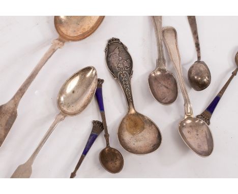
A quantity of mainly Scandinavian white metal, including three sterling and enamel coffee spoons by Egon Lauridsen and a spoon with a map of Denmark to the terminal, gross weight 168gm CONDITION REPORT: Condition information is not usually provided in the description of the lot, but is available upon request. Further images and some condition reports can be viewed on our online catalogue at www.chorleys.com

The Krima or Crimea Peninsula, the Tauris of Ancient Geographers, reduced from the Original Russian military map, constructed under the direction of Major-General Mukhin, by the staff of the Russian quarter-master general, by command of the governor general Prince Volkonski, inscribed to Her Most Gracious Majesty Queen Victoria, by her very devoted and faithful servant T.B. Jervis F.R.S. Major of the Corps of Engineers E.I. Service, London, September, 1854, folding map CONDITION REPORT: Condition information is not usually provided in the description of the lot, but is available upon request. Further images and some condition reports can be viewed on our online catalogue at www.chorleys.com
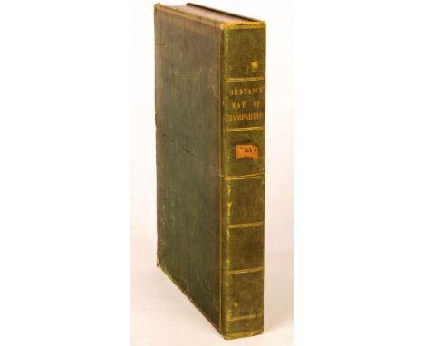
Baker (B) Ordnance Map of Hampshire, published by Col. Mudge Tower, 14th Aug 1817, folding map of 52 linen backed panels, 465cm x 91cm and the green morocco slip for the same CONDITION REPORT: Condition information is not usually provided in the description of the lot, but is available upon request. Further images and some condition reports can be viewed on our online catalogue at www.chorleys.com


After Captain Hayter/A Chart of the Coast of Pegu with the Adjacent Coast of Arakan and Tanasserim from A Drawing Communicated by Captain Hayter, with Several Additions & Improvements from the Neptune-Orientale, Capt. John Ritchie, Capt. Charles Newland, and others, published by Laurie & Whittle, 12th May 1794, 91cm x 63.5cm, another version published 12th September 1798; after Jean-Baptiste-Nicolas-Denis d'Après de Mannevillette (1707-1780)/Carte de la Cote de Pegou, 36cm x 50.5cm and Carte Reduite du Golfe de Bengale, 50cm x 68.5cm and a folding map of the Western and Central Nan-Shan CONDITION REPORT: Chart of Pegu- Selotape repair to border. Rip at half fold and pieces missing to lefthand margin.Other chart of Pegu- Creased across the middle. There is a secondary fold and vertical folds torn at both top and bottom.
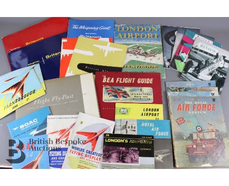
Quantity of aviation ephemera with Bristol Britannia and Farnborough interest; two Bristol Britannia Aircraft brochures August 1956 and September 1957 - 32 page brochures, photographs and specifications, flight decks and seating for Bristol Britannia aeroplanes with 3 fold out brochures of Britannia and Bristol engines, Flight Fly-Past - portfolio of aircraft photographs by Flight cameramen, Comet Highway by Henry Hensser publ.1953 John Murray 1st edition in dust jacket, 4 Bristol Review Magazines from 1957, 1958 and 1959, The Aeroplane Pictorial Review no.3 1958 in dust jacket, How To Fly by Lawrence C Bagley publ. Blackie in dust jacket, Book for Boys with period illustrations, Ian Allan London Airport Guide, BOAC Book of Flight 1959, BOAC Route Map and Flight Information (VG+), BEA Flight Guide maps and information, Farnborough Airshow Flying Display and Exhibition 1949, 1953 (damage to back), 1954, 1955, 1956 x3, 1957, 1959 x2, 1961, 1964, 1966 and 1968. Mostly very good clean condition, one box.

-
109182 item(s)/page