We found 109198 price guide item(s) matching your search
There are 109198 lots that match your search criteria. Subscribe now to get instant access to the full price guide service.
Click here to subscribe- List
- Grid
-
109198 item(s)/page


Lot 318
Transport.- Guide (A) to Stage Coaches, Mails, Diligences, Waggons, Caravans, Carts, Coasting Vessels, Barges and Boats which carry Passengers and Merchandize from London Westminster and Southwark..., 128pp., folding engraved map, contemporary half vellum stained green, 8vo, W. Lowndes, No.76, Fleet Street, [1795].⁂ One of several editions but only 3 copies of this one on ESTC (BL; Cornell University; National Library of Australia).

Lot 319
Bindings.- Treble Almanack (The) for the Year MDCCXCVII, 3 parts in 1 (comprising: Watson Stewart (John) The Gentleman's and Citizen's Almanack...; Exshaw (John) The English Registry...; Wilson's Dublin Directory), engraved calligraphic general title (slightly shaved at edges), final work with folding engraved map of Dublin tipped to rear pastedown (torn), first work partly interleaved, some leaves with 2d. duty stamp in red ink, bound in attractive red roan with decorative gilt tooled border, spine gilt with horizontal gilt ornamental waves, g.e., slightly rubbed and marked, blue roan label worn, corners bumped, Dublin, 1797 § MDCCCI. Peacock's Polite Repository, or Pocket Companion; containing An Almanack..., engraved frontispiece, title and several blank leaves for diary, accounts etc. with small engraved vignettes or headings, contemporary red roan with onlaid strips of black and cream elaborately decorated in gilt with matching slip-case, both a little rubbed and soiled, W.Peacock, 1801, 8vo & 16mo (2)
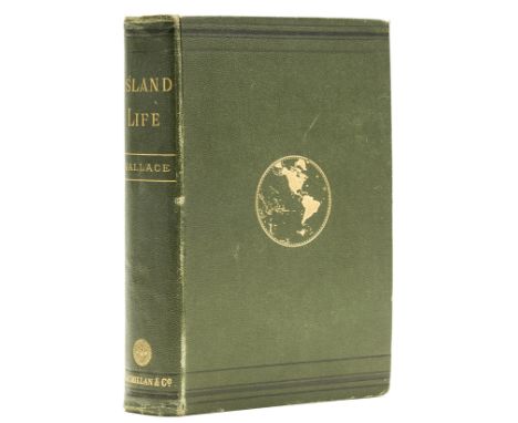
Lot 331
Wallace (Alfred Russel) Island Life: or, the Phenomena and Causes of Insular Faunas and Floras, including a revision and attempted solution of the problem of Geological Climates, first edition, 3 maps, one hand-coloured, text maps and diagrams, advertisement leaf at and, hand-coloured map foxed, occasional other light spotting or soiling, joints weak, original pictorial cloth, gilt, t.e.g., others uncut, a little rubbed, 8vo, 1880.⁂ Sequel to the author's Geographical Distribution of Animals of 1876, both ground-breaking works of zoogeography.
Lot 332
Africa.- Richardson (James) Travels in the Great Desert of Sahara, in the years of 1845 and 1846, 2 vol., first edition, engraved portrait, 2 plates and folding map, wood-engraved illustrations, some foxing, contemporary calf, gilt, roan labels, rubbed and scuffed, 8vo, 1848.⁂ James Richardson (1806-51) was an ardent campaigner against slavery and set out on this expedition to explore the area south of the Sahara to Timbuktu and Niger and discover more about the slave trade and how it would be possible to suppress it.
Lot 333
Americas.- Canada.- Heriot (George) Travels through the Canadas, first edition, fine folding aquatint frontispiece of Quebec and 26 aquatint plates after the author, all hand-coloured, 6 folding, hand-coloured folding engraved map of St.Lawrence River, tissue guards, 8pp. publisher's catalogue at end, light browning and occasional offsetting, some foxing to tissue guards, engraved bookplate of Melmoth Guy, unusual contemporary green and red glazed boards edged with gilt paper strips, uncut, rubbed and yellowed, scuff to lower cover, rebacked in red morocco, gilt, [Hill 801; Sabin 31489; cf.Abbey, Travel 618 (plates only)] 4to, 1807.⁂ "The earliest and most important aquatint book published on Canada". (Hill). It includes much information on Native Americans and their customs, linguistics and agriculture, as well as details of the fur trade and fisheries.
Lot 336
Americas.- Hennepin (Louis) A New Discovery of a Vast Country in America, Extending above Four Thousand Miles, between New France and New Mexico...With a Continuation, 2 parts in 1, second English edition, engraved frontispiece, 2 folding maps and 6 folding plates, contemporary ink signature of Chas. Halkett to title and Sir John Halkett to verso of frontispiece with bookplate of Pitfirrane Castle, rather browned, particularly towards end, first folding map with tear, paper flaw tear/hole to lower edge of G3 and 2H3 just touching text, slight worming to outer margin, contemporary panelled calf, worn patch to upper cover, spine a little worn, upper joint split, [Sabin 31372; Wing H1452], 8vo, for Henry Bonwicke, 1699.⁂ Early account by a French missionary of his travels in the North American interior exploring the basin of the Mississippi River, and including the first printed description and engraving of Niagara Falls. ESTC cites only 5 UK copies.

Lot 347
Voyages.- Hakluyt (Richard) The Principal Navigations, Voyages, Traffiques and Dicoveries of the English Nation, made by Sea or overland..., 3 vol. in 2, second edition, second issue, printed in black letter, woodcut ornament on titles, woodcut head-pieces and initials, lacking the folding engraved map (as usual) but with the suppressed leaves on the conquest of Cadiz pp.607-619 (first state), title of vol.3 defective at lower outer corner with loss to ends of a few lines (repaired, loss supplied in manuscript, mostly to imprint), titles and final leaves a little soiled, some light water-staining, mostly marginal, a few other small stains, slight worming to vol.2 affecting a few letters of one line but not sense and to inner margin towards end, vol.1 with manuscript leaf of agricultural accounts for the Dorvil family dated 1696-1704 written on verso of title-page of a prayer loosely inserted, vol.1 & 2 contemporary calf with central arabesque lozenge in gilt and old cloth ties, spine in compartments with small gilt ornaments and eight raised bands, red morocco label chipped, rubbed, spine a little faded and worn at head, a few small stains, wormhole to lower cover, ties frayed and defective, vol.3 18th century mottled calf, spine gilt with roan labels, g.e., rubbed, spine rather worn and chipped, joints split, old rather crude repair to upper joint, [Hill 743; Sabin 29596-29598; STC 12626a], folio, by George Bishop, Ralph Newberie, and Robert Barker, 1599-1600. ⁂ Monumental record of Elizabethan exploration and greatly expanded from the first edition of 1589; vol.3 is entirely devoted to the Americas. Vol.1 is a reissue of the 1598 edition with a new title-page.

Lot 348
World.- Malham (Rev. John) The Naval Gazetteer; or Seaman's Complete Guide, 2 vol., large folding engraved map of the world and 16 folding engraved maps and charts, large map with small tear to inner edge, some foxing, contemporary tree calf, rubbed, staining to upper cover of vol.1, spines worn at head, 8vo, for M.Allen, 1799.
![Miniature books.- Wallis (John, publisher) [The Book-Case of Knowledge], 10 vol., comprising Geography and Astronomy Familiar](https://cdn.globalauctionplatform.com/ce30ce3c-e8a9-49d1-8af6-aa6201074571/f5bbcd1f-41aa-4ce6-9c7a-aa6c00fb32e6/468x382.jpg)
Lot 490
Miniature books.- Wallis (John, publisher) [The Book-Case of Knowledge], 10 vol., comprising Geography and Astronomy Familiarized for Youth of Both Sexes (double-hemisphere frontispiece map and engraved plate of the solar system); A Familiar Introduction to Botany (5 hand-coloured engraved plates); A Natural History of Birds and Beasts (16 engraved plates); The History of England, from the Conquest to the Death of George II (engraved frontispiece and hand-coloured circular portraits in text); Rewards for Attentive Studies (engraved frontispiece); Mythology (engraved frontispiece); A Compendium of Simple Arithmetic (engraved frontispiece); Scripture History (engraved frontispiece); Short and easy Rules for Attaining a Knowledge of English Grammar (engraved frontispiece); British Heroism (engraved frontispiece), occasional spotting, the odd small stain, original (marbled) paper-backed colour boards, all apart from British heroism with original printed paper label to upper cover, rubbed, 16mo (each c.95 x 51mm.), J. Wallis, 1800-1801.

Lot 495
Ravilious (Eric).- White (Rev. Gilbert) The Writings of Gilbert White of Selborne, edited by H.J.Massingham, 2 vol., number 310 of 850 copies, fine wood-engraved pictorial titles and head- & tail-pieces by Eric Ravilious, folding map, original grey buckram, gilt, t.e.g., others uncut, spines gilt with animal motifs and a little faded (as usual), t.e.g., others uncut, together in marbled board slip-case, [Dreyfus 114], 8vo, Nonesuch Press, 1938.

Lot 501
Wadsworth (Edward) Windeler (Bernard) Sailing-Ships and Barges of the Western Mediterranean and Adriatic Seas, number 20 of 450 copies, fine delicately hand-coloured copper-engraved additional title, 17 plates, map and several vignettes by Edward Wadsworth, light spotting to one plate, book-plate of A.E.Franklin, original buckram-backed pictorial orange cloth, gilt, uncut, spine a little soiled, original board slip-case with label, soiled and worn, part of one edge detached (preserved in envelope), small folio, printed at the Curwen Press for Etchells & Macdonald, 1926.
Lot 524
China.- Semedo (Alvaro) The History of that Great and Renowned Monarchy of China, first edition in English, engraved portrait frontispiece, 2 plates, 1 folding engraved map, short tear, 1 map in text, publisher's advertisement at end, 2 small rust holes (M4 & N1), small tear to top edge (S3), ex-library with label to end pastedown and occasional discreet ink stamps, blind stamp to frontispiece corner, occasional marginal soiling, 20th century library buckram, rubbed and worn, [Wing S2490], 4to, E. Taylor for John Crook, 1655.⁂ An important account of China.
Lot 527
India.- Burton (Sir Richard Francis) Goa, and the Blue Mountains; or, Six Months of Sick Leave, first edition, second issue, lithographed frontispiece and 3 plates, folding engraved map, 2 short marginal tears, scattered faint spotting, school presentation inscription to front free endpaper, cracked hinges, original blue decorative cloth, gilt, rubbed, slight bumping to corners and extremities, [Penzer pp.37-38], 8vo, 1851.

Lot 530
Mexico.- Castro (Casimiro) and Garcia Cubas (Antonio). Album del Ferrocarril Mexicano, Coleccion de vistas pintadas del naturel, titles and text in Spanish and English, French summary at end, 25 chromolithograph plates including pictorial title by Castro and Sigogne after Castro, text by Cubas, lacking the double-page map, a little marginal spotting, the half-title inscribed to Dr. E.F. Cleveland of Dundee, Illinois by Dr. Jesus Diaz de Leon (1851-1919), polymath member of the Academia Mexicana de la Lengua, modern morocco-backed cloth, tissue guards, [Palau 98733; Mathes, Mexico on Stone p.18 et seq., "Some of the finest examples of the lithographer's art during the latter part of the century"], oblong folio, Mexico, Establecimiento Litografico de Victor Debray, 1877
![Scotland.- [Leveson-Gower (Elizabeth, Marchioness of Stafford, later Duchess of Sutherland)] Views in Orkney and on the North](https://cdn.globalauctionplatform.com/ce30ce3c-e8a9-49d1-8af6-aa6201074571/1a2487aa-394e-46d3-9895-aa6c00fafefa/468x382.jpg)
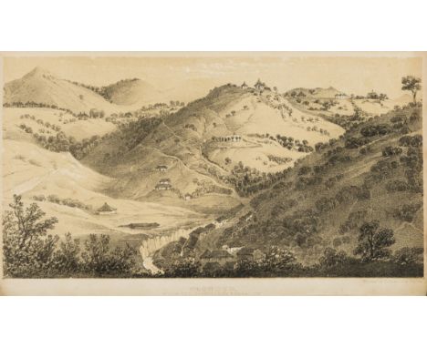
Lot 531
Scotland.- [Leveson-Gower (Elizabeth, Marchioness of Stafford, later Duchess of Sutherland)] Views in Orkney and on the North-Eastern Coast of Scotland, [one of 120 copies for presentation to friends], this copy with slip inscribed "Sir George Beaumont Bart. with Ly Stafford's compts." tipped to front free endpaper (?part of original wrapper), half-title, etched title with vignette map, 12 vignettes and 31 plates on 28 sheets, mostly views, half-title and title foxed, some other spotting, mostly marginal or to tissue guards, handsome contemporary straight-grain turquoise morocco with border of gilt rules and ornaments, spine gilt in compartments with ornaments and five double raised bands, turn-ins with gilt rules & corner-pieces and dentelles in blind, g.e., a little rubbed and spotted, endpapers slightly damp-stained, folio, [privately printed], 1807.⁂ Sir George Beaumont (1753-1827) was an art collector, patron and amateur painter. He was a founding member of the British Institution and had strong and influential views on contemporary artists, favouring Constable but harshly critical of Turner. He was instrumental in the establishment of the National Gallery in 1824 by promising to donate 16 of his Old Master paintings, on condition that the government purchase the collection of the recently-deceased John Julius Angerstein for the nation. His paintings formed the first bequest the following year. The author's husband, the Marquess of Stafford, was also a significant art collector, having inherited a fine collection from his uncle which he greatly expanded, helped by being fabulously wealthy.
Lot 533
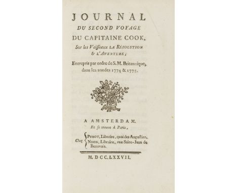
Voyages.- Cook (Capt. James).- Marra (John) Journal du Second Voyage du Capitaine Cook, sur les Vaisseaux La Resolution & l'Aventure, first edition, half-title, folding engraved map at end, occasional light foxing and browning, contemporary French mottled calf, spine gilt, upper joint starting to split at head, corners and head of spine slightly chipped, [Beddie 1272; Du Rietz, Bib. Polynesia 812], 8vo, Amsterdam, Pissot & Nyon, 1777.


Lot 17442
Portugal - Colonies - Mozambique : 1876-1990 EXTENSIVE ORIGINAL COLLECTION on leaves; starts Crown types,1876,Perf.12½ most to 300r inc.50r Green f.u.Perf.13½ to 300r, 1881-5 Colour changes inc.20r Rosine m.m.(thin spot), 1886 King types to 300r,1894 Perf.11½ vals.to 200r, Perf.12½ vals.to 300r, 1895 700th St.Anthony ovptd.vals.1898 Surcharges inc.both 2½r on 20r types c.d.s.1898-1901 Tablet types to 700r most m.m.1902 Surch.vals to 400r on 300r, 1902 Colour changes to 400r m.m.1911 'Republica' ovpts.to 700r m.m.1914 Ceres types to 1E, 1912 'Republica' ovpts.to 500r, 1913 all 3 Vasco da Gama sets, m.m.1920 and later Charity Tax sets m.m.1919-26 Ceres set to 20E m.m.1927 & 1928 C/Tax set m.m.1930-1 Albuquerque set, m.m.1933-47 'The Lusiads' set to 20E m.m.1938 V.da.G.set to 20E m.m.1939 Colonial Tour (Map) set m.m.1948 Fayima set m.m.1948-9 Views set to 20E m.m.Then comprehensive later issues through to 1990, inc.1951 Fishes set c.d.s.1953 Butterflies set m.m.Then AIRMAILS inc. 1938 set to 10E m.m.1946 to 3R, Similar set ovptd.'Taxe Percue' c.d.s.POSTAGE DUES inc. 1904 to 500R m.m.1911 Ovptd. Set m.m.Also many Tax sets, etc. Generally very clean, some minor faults noted. Many scarce items and high catalogue value.m.m.or c.d.s. (Some 100s) [US1]
![Atlases.- Saxton (Christopher) [An Atlas of England and Wales], first edition, engraved frontispiece depicting Queen Elizabet](https://cdn.globalauctionplatform.com/0b84f1ff-a423-4074-96a9-aa6201071b1b/50b3793e-6385-46bf-9ad9-aa650108d936/468x382.jpg)
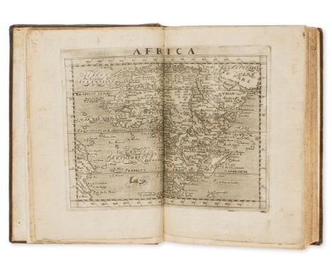
Lot 37
Atlases.- Saxton (Christopher) [An Atlas of England and Wales], first edition, engraved frontispiece depicting Queen Elizabeth seated, surrounded by allegorical figures of astronomy and cartography (Hind first state with Elizabeth's dress stretched across her knees, trimmed to margins and laid down), 34 engraved double-page and folding maps only (of 35, lacking the general map of England and Wales), all coloured in a contemporary hand, ?lacking the double page coats-of-arms & gazetteer plate and the letterpress index leaf (supplied in manuscript in red and black in a later hand), all maps with the bunch of grapes watermark visible, with 11 maps bearing Seckford's pre-1576 motto (Pestis patriae pigricies), and 23 his later motto (Industria naturam ornate), occasional light browning and offsetting to maps, a few maps with short tears to central folds, Hertfordshire and Denbigh with vertical crease, folding map of Yorkshire with neatly repaired tear, 1 or 2 maps closely shaved, an interleaved copy with manuscript tables of rent owed for certain hundreds in a near-contemporary hand to 7ff., ink ownership inscriptions to pastedown, contemporary calf, gilt, covers with gilt corner-pieces surrounding central gilt lozenge, neatly rebacked, preserving original backstrip, rubbed, lacking clasps, folio, Christopher Saxton, 1579 [?but c.1590].⁂ First edition of the earliest and most-celebrated atlas of England and Wales with a good contemporary provenance. At the behest of Thomas Seckford, master of requests to Queen Elziabeth, Saxton undertook a survey of the British counties between 1570 and 1578 and first issued his atlas in 1579.Provenance: The earliest ownership inscription reads "Geo. Cotton" and is dated 1589, below in a later hand reads "my Grand father gave me this book ano 1645" below this is the final inscription "Combermere, Robert Wellington 1896". The first inscription is likely that of George Cotton (1560-1646), grandson of Sir George Cotton (1505-1545), Sherriff of Denbighshire and courtier to Henry VIII. Henry VIII granted George Cotton the former abbey of Combermere in 1541. The hundreds listed are in Herefordshire, Denbigh, Flintshire, Anglesea, Caernarvon, Merionethshire, Montgomeryshire and Brecknockshire.
Lot 61
Africa.- Leo Africanus (Joannes) A Geographical Historie of Africa, written in Arabicke and Italian by John Leo a More, borne in Granada, and brought up in Barbarie... translated and collected by John Pory, first English edition, engraved double-page map of Africa (neatly mounted on stub), title with woodcut device, woodcut initials, light marginal damp-staining towards end, final f. a little soiled with margins chipped, occasional light marginal soiling, paper flaw to F6 margin just touching text, ink ownership inscription to head of dedication, contemporary calf, lacking clasps, neatly and sympathetically rebacked, preserving original backstrip, corners bumped, later endpapers, [Sabin 40047; Sabin 15481], folio, Georg. Bishop, 1600.⁂ First edition in English of the first book on Africa written by an African. Johannes Leo Africanus, whose real name was Hasan ben Mohamed Alfasi, was a well-educated arabian geographer. He had travelled all over the Moslem African countries and in 1517 was captured by Christian pirates, who took him and the manuscript of his travels to Rome. There, under the protection of Pope Leo X he translated his manuscript into Latin for publication.Provenance: Thomas Smith (ink inscription dated 1623).
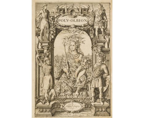
Lot 78
Drayton (Michael) Poly-Olbion. Or A Chorographicall Description of...Great Britaine...Digested in a Poem, first edition, second issue, additional engraved title and portrait of Henry I by William Hole, the latter remargined, washed and pressed (probably from another copy), 18 double-page engraved maps, some trimmed within platemark, 18th century sprinkled calf, rebacked preserving original gilt spine, a little rubbed, [STC 7227; Pforzheimer 308; Hayward 43], folio, Printed by H.L. for Mathew Lownes: I. Browne: I. Helme, and I. Bushie, 1613.⁂ The Boies Penrose copy (with bookplates) of Drayton's great poetical survey in praise of Britain with each of the 18 songs accompanied by a map of the region celebrated. This copy is of the second issue with the printed title dated 1613, the maps bearing page numbers, and the 4-page table bound in before the main body of the work.
![Tyrone's Rebellion.- [Stafford (Thomas)] Pacata Hibernia. Ireland Appeased and Reduced..., 2 fine engraved portrait frontispi](https://cdn.globalauctionplatform.com/0b84f1ff-a423-4074-96a9-aa6201071b1b/6f0a981b-04c5-418c-a3ab-aa65010954aa/468x382.jpg)
Lot 101
Tyrone's Rebellion.- [Stafford (Thomas)] Pacata Hibernia. Ireland Appeased and Reduced..., 2 fine engraved portrait frontispieces of George Carew and Elizabeth I, folding map and 17 other maps, plates and plans, most folding or double-page, woodcut initials, head- and tail-pieces, a few plate margins trimmed, folding map with a few tears at folds, Castle of Glin plate with neatly repaired tear, contemporary calf, rebacked, covers with gilt stamped 'D. C.' monogram, [STC 23132], folio, by Aug: Mathevves for Robert Milbourne, at the signe of the Grey-hound in Pauls Church-yard, 1633.⁂ A good copy of Stafford's account of the Nine Years War in Ireland. Stafford was the secretary (and supposed illegitimate son) of George Carew, one of the central figures of the war.
Lot 162
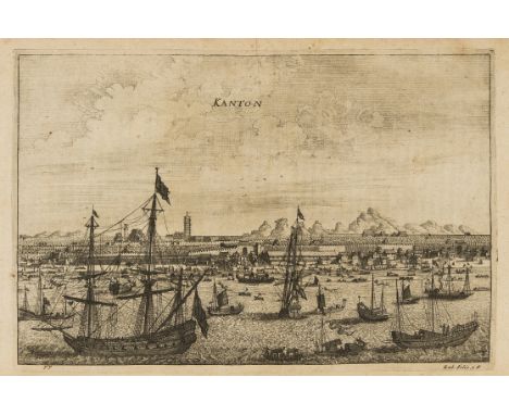
China.- Nieuhoff (Jan) An Embassy from the East-India Company of the United Provinces, to the Grand Tartar Cham Emperour of China... [with] an Epistle of Father John Adams. . . [and] Several Remarks taken out of Father Athanasius Kircher. Englished. . . by John Ogilby, 3 parts in 1 vol., first edition, title printed in red and black, engraved additional title, portrait, double-page map, double-page plan and 17 plates, 121 engraved illustrations in text, engraved initials and head-pieces, with 2P2 but lacking e2 and final blanks, title a little soiled, many ff. torn at lower margin, Z1, 2Q1, 2Y2-2X2, 3E2 and 1 plate with longer tears running into text or image, 2F2 with repaired tear to head, occasional light browning, ink inscriptions to pastedown, contemporary calf, rebacked and recornered, [Wing N1152], folio, by John Macock for the author, 1669.⁂ Important account of the Dutch East India company's official visit to the Emperor Chun Chi in Peking in an attempt to persuade him to open up the Chinese ports to Dutch trade. The illustrations show town views, costume and natural history subjects and provided the European readership with significant and reliable information about the Chinese empire.Provenance: James Taylor; Elzabeth Taylor (ink inscriptions).
Lot 190
Sri Lanka.- Knox (Robert) An Historical Relation of the Island of Ceylon, in the East-Indies: together with an Account of the Detaining in Captivity of the Author and Divers other Englishmen now Living There, and of the Author's Miraculous Escape, first edition, title within double-ruled woodcut border, engraved folding map and 15 plates, license f. before title, without the portrait (as usual), advertisement f. at end, B1 with old paper tab tipped onto fore-edge, very occasional light damp-staining to lower corners, the odd spot, bookplate to title verso, contemporary calf, joints splitting at ends, corners bumped, rubbed, [Wing K742], folio, by Richard Chiswell, printer to the Royal Society, at the Rose and Crown in St. Paul's Church-yard, 1681.⁂ The first account of Ceylon in English, and one of the sources for Defoe's Robinson Crusoe. While sailing for Persia in 1658, Knox's ship lost its mast in a storm and was forced to put ashore on Ceylon. Knox, along with his elder brother and crew, was captured by King Rajasinha II of Kandy and refused permission to leave the kingdom. Knox and a companion eventually escaped after 19 years of captivity and fled to a Dutch fort on the north of the island. Provenance: Charles Viscount Bruce (armorial bookplate).
Lot 200
Americas.- Pirates.- Exquemelin (Alexandre Olivier) Bucaniers of America: Or, a true Account of the Most remarkable Assaults Committed of late years upon the Coasts of The West-Indies, 3 parts in 1 vol., first edition in English, 9 engraved plates, 3 folding (including folding map of Panama), 1 plate with lower margin restored, occasional light soiling or marginal damp-staining, but a good copy generally, ink ownership inscription to title, contemporary calf, rebacked and recornered, [Sabin 23479; Wing E3894], 4to, for William Crooke, at the Green Dragon without Temple-bar, 1684.⁂ One of the most popular and widely imitated of the accounts of piracy in the Americas. The lives of the buccaneers included in the work were liberally embellished to such an extent that Captain Morgan, one of the most notorious of those featured, successfully sued for slander and was awarded £200.Provenance: Roger Mostyn (ink inscription).
Lot 226
Buccaneers.- Hacke (William, editor) A Collection of Original Voyages: I. Capt. Cowley's Voyage Round the Globe. II. Captain Sharp's Journey over the Isthmus of Darien, and Expedition into the South Seas, Written by himself. III. Capt. Wood's Voyage thro' the Streights of Magellan. IV. Mr. Roberts's Adventures among the Corsairs of the Levant; his Account of their Way of Living; Description of the Archipelago Islands, Taking of Scio, &c. London, first edition, title within double-ruled woodcut border, 3 engraved folding maps by Herman Moll (folding world map tipped onto A8 fore-edge) and 3 engraved plans, 3pp. advertisements at end, D8 blank outer margin foreshortened, bookplate to front free endpaper, contemporary half calf, sympathetically rebacked, [Blackmer 771; Sabin 29473; Wing H168], 8vo, for James Knapton, at the Crown in St. Paul's Church-Yard, 1699.⁂ First edition of an important source book for contemporary accounts of piracy. Hacke here claims to be a buccaneer himself but was in fact a map maker based in Wapping. Provenance: William Alexander (bookplate).

Lot 49
MICHAEL CARLO (b. 1945) Haymaking at Wivenhoe Park, etching in colours, pencil signed, dated '89, titled and numbered 22/50 in the margin, 20 x 27cm; further various prints and engravings to include: two French engravings; four Manchester subjects; 'Dr Johnson in the Ante-Room of Lord Chesterfield', 'Wolsey's Gate'; a map of Colchester; and a print after Karl Spitzweg - 'The Bookworm' (11)


Lot 88
JOHANN BAPTISTE HOMANN 'A General Map of Great Britain and Ireland with part of Holland, Flandres, France etc', double-page engraving, with decorative title cartouche and inset vignette of the Shetland Islands, 49 x 56cm; and Johann Baptiste Homann - 'El Reyno de Espanna...', double-page engraving, 50 x 60cm, both unframed (2)


Lot 522
ALLEN, FRED H, THE GREAT CATHEDRALS OF THE WORLD, Boston, Haskell & Post, 1886. Two volumes, large folio, fine photogravure plates. original publisher's brown cloth, worn, joints split but firm, original wrappers bound in. Plus two other topography volumes, being: William Kennedy's "Annals of Aberdeen", 1818, vol 1 only, folding coloured plate, and: Edwin Trueman's "History of Ilkeston", 1899, with large folding coloured map, boards detached, old tape marks to half-title (4)

Lot 246
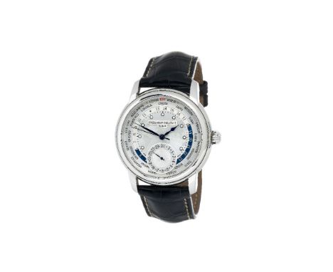
ϒFrederique Constant, World Timer, ref. FC-718WM4H6, a limited edition stainless steel wrist watch, no. 0984/1888, automatic movement, 26 jewels, cal. FC 700/710/718, silvered world map dial, applied luminous dot markers, blued steel, feuille minute and spade hour hands, centre seconds hand, rotating outer 24 hour and city index, subsidiary date dial, screw down glazed back, on a Frederique Constant black crocodile strap with a stainless steel pin buckle, case back, dial, movement, strap and buckle signed, 42mm The world timer complication builds on the function of the GMT and takes it further. It allows the wearer to tell the time from a different time zone around the globe at a glance of the wrist. ϒ Indicates that this lot may be subject to CITES regulations when exported. Please see our Terms & Conditions for more information.

![[Antiquarian Bindings] A collection of largely odd volumes including The Beauties of Shakespeare by William Dodd 1780, The Wo](https://cdn.globalauctionplatform.com/53dbc596-d233-490c-bafd-aa7e00a3e447/55a63125-7cd2-4825-8520-aa7f0107cd76/468x382.jpg)
Lot 195
[Antiquarian Bindings] A collection of largely odd volumes including The Beauties of Shakespeare by William Dodd 1780, The Works of Virgil by Dryden 1763 with engraved plates, Gay’s Fables illustrated with engravings, Works of Dr. Jonathan Swift 1765 illustrated, The Inspector volume the second 1753, Works of Mr. Abraham Cowley 1711, Poems by John Hughes 1735, Jacobi Vanierii, Des Postes du Royaume De France 1818 with map and others all in leather (20)

Lot 197
Bairnsfather A Few Fragments From His Life Collected by a Friend published Hodder & Stoughton (1916) illustrated, The Life The Works and Collectables of Bruce Bairnsfather, Marine Radio Operator’s Guide, Australian Army at War 1944, Battle of Normandy Michelin Tyre map, Europe Since Versailles by Low, Story of Operation Overlord and other pamphlets
![[Jane Austen Family Association] Mansfield Park A Novel by Jane Austen published George Routledge (c1870) with engraved illus](https://cdn.globalauctionplatform.com/53dbc596-d233-490c-bafd-aa7e00a3e447/cbb8385b-cef6-4a5f-8a09-aa7f010b605e/468x382.jpg)
Lot 241
[Jane Austen Family Association] Mansfield Park A Novel by Jane Austen published George Routledge (c1870) with engraved illustration, Ex Libris bookplate of Montague George Knight of Chawton (great nephew of Jane Austen) gilt and black cloth and The Old and New Testament by Humphrey Prideaux part II printed 1729 with folding map and engraved frontispiece, containing bookplate of James Edward Austen-Leigh (Nephew of Jane Austen) in contemporary leather binding with raised bands (2)


-
109198 item(s)/page