We found 109198 price guide item(s) matching your search

Refine your search

Year

Filter by Price Range
  • List
  • Grid
  • 109198 item(s)
    /page

Lot 62

Scotland.- Ortelius (Abraham) Scotiae Tabula, map of Scotland, oriented with north to the right, with large strap-work title cartouche in the upper right corner, sea monster and ship, engraving with hand-colouring on laid paper with armorial watermark, platemark 352 x 474 mm (13 7/8 x 18 5/8 in), sheet 445 x 550 mm (17 1/2 x 21 1/4 in), Latin text verso, central vertical fold, minor handling creases, light surface dirt, faint damp-stains to margins, unframed, [Antwerp, circa 1603].Literature:VdB 18.3⁂ One of the earliest maps to show Scotland separately.

Lot 9

NO RESERVE Central Asia.- De L'Isle (Guillaume) Carte de Tartarie Dressee sur les Relations de Plusieurs Voyageurs de Differentes Nations et sur Quelques Observations..., map showing from Eastern Ukraine and Crimea to South Korea, including Russia, Northern China, and Tibet, engraving with outline hand-colouring, platemark 500 x 615 mm (19 3/4 x 24 1/4 in), sheet 545 x 640 mm (19 7/8 x 26 in), central vertical fold with restoration verso, verso with thin conservation tissue support, unframed, Covens & Mortier, Paris, [1706].

Lot 90

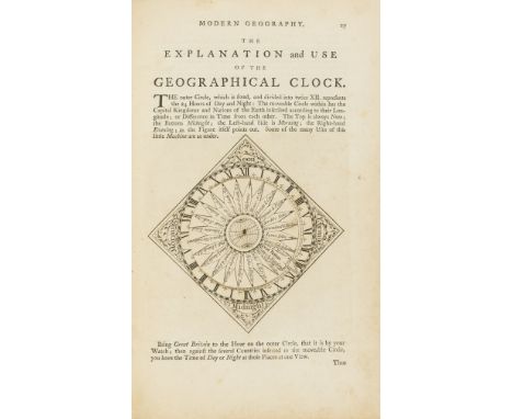
NO RESERVE Astronomy, Mathematics & Globes.- Turner (Rev. Richard) A View of the Heavens: Being a Short, but Comprehensive System of Modern Astronomy... To which is added, The Use of the Cælestial Globe, first edition, 2 engraved plates, engraved illustrations in text, that of astronomical clock on p.41 with volvelle, 1765; A View of the earth: being a short, but comprehensive system of modern geography. ... To which is added, a description of the terrestrial globe, second edition, engraved double-hemisphere world map, 5 other maps (including America and Asia), plate of terrestrial globe and illustrations within text, that of geographical clock on p.27 with volvelle, 3pp. advertisements at end, 1766; Plain trigonometry rendered easy and familiar, by calculations in arithmetick only: With Its Application and Use In ascertaining all Kinds of Heights, Depths, and Distances, In The Heavens, as well as on the Earth and Seas, first edition, woodcut diagrams, 1p. advertisements at end, 1765, together 3 works in 1 vol., titles in red and black, some spotting and finger-marking, occasional staining, lightly browned, contemporary calf-backed marbled boards, worn, but holding, Printed for S. Crowder, small folio⁂ A very good sammelband of richly illustrated works by this former student of Magdalen College, Oxford. Provenance: William Peacock (charming 1769 bookplate within typographic border and '-/2 6d Mr Peacock' to foot of final verso).

Lot 132

AFTER BLAEU, CORNELIUS (1610-1644), REPRINT, MAP OF WESTPHALIA 40cm x 50cm, in Hogarth frame and glazed, gifted to the vendor's family as part of the 1973 twinning of Dorchester with Lubbecke in Westphalia

Lot 152

BOWEN, EMMANUEL (1694-1767) AND OWEN, JOHN, THREE COLOURED 'ROAD MAP' ENGRAVINGS comprising Kingston to Portsmouth, Dunkton to Weymouth and the road to Truro

Lot 155

BOWEN, EMMANUEL (1694-1767) AND OWEN, JOHN, TWO COLOURED 'ROAD MAP' ENGRAVINGS comprising Exeter to Truro and Bristol to Westchester, each 19cm x 12cm in double sided Hogarth frames and glazed

Lot 178

GIBSON, JOHN (1750-1792), COLOURED ENGRAVING, MAP OF THE ROAD FROM LONDON TO LANDS END produced for the Gentleman's Magazine, 19cm x 44cm, in later Hogarth frame and glazed

Lot 200

A vintage map of St. Austell in sleeve, two Cornwall related calendars, 1956 & 1962 with two maps of Great Hewas, Cornish tin mining, both laminated

Lot 970

STANLEY, A.P. Historical Memorials of Westminster Abbey 2 vols. c.1900, New York, 8vo orig. gt. dec. cl. d/ws, plus HALL, S. Documents From Simancas Relating to the Reign of Elizabeth 1865, London, 8vo orig. cl. plus HUNTER, J. An Introduction to the Vater Ecclesiasticus of King Henry VIII 1834, London, 8vo orig. cl. fldng. map (4)

Lot 977

MALLOWAN, M.E.L. Nimrud and its Remains 2 vols. plus map vol. 1975, London, 4to orig. gt. dec. cl. d/ws, s/case

Lot 981

WHITE, W. Directory... Hampshire and The Isle of Wight 1st.ed. 1859, 8vo orig. cl. lacks map, plus 6 other UK topography (7)

Lot 1113

FID G1-8 (1946–49). Thick map set. Fine used Cat £27 plus ? G6e ochre shade mint. Cat £55

Lot 51

Willelm Janszoon (1571-1667) map of Venezuela 37.5cm x 49cm hand coloured.

Lot 52

Willelm Janszoon (1571-1667) map of Granda hand coloured. W:49cm x H:37.5cm

Lot 837

Maps. A framed and glazed Ordnance survey map of North Devon, a framed Times map of Eastern Queensland and 2 vintage Ordnance survey maps W:85cm x H:78cm Dimensions of largest

Lot 68

A 19th century map of the County of Hertford by C. & J. Greenwood, 1834, framed and glazed

Lot 49

Lee (Kerry), 'London, The Bastion of Liberty', published by The Travel Association of The United Kingdom, circa 1950, large colour lithograph pictorial map of London, 95 cm x 119 cm glazed in an oak frame.

Lot 376

Albert Ruger (American, 1829-1899) and J.J. Stoner (American, 19th c.) published by Beck and Pauli Lithographing Co, United States. Lithograph on paper titled "Panoramic View of the City of Minneapolis Looking North West, Minnesota, 1879" depicting a bird's eye view of the city of Minneapolis with locations marked by numbers and listed below the map.Provenance: Distinguished corporate collection, Minnesota.Sight; Height: 19 1/4 in x width: 31 1/4 in. Framed; Height: 28 in x width: 40 in.

Lot 114

ATLASES: 'The Authentic Map Directory of London and Suburbs...4th edition', London, Geographia Ltd, circa 1930: small folio, publishers green cloth, hinges cracked: together with a Bartholomew 'Royal Atlas of England and Wales' of similar period. (2)

Lot 119

VANCOUVER (Charles): 'General View of the Agriculture of the County of Devon; with observations on the means of its improvement..', London, Richard Phillips, 1808: with hand coloured folding engraved map as frontispiece, 28 engraved plates (several folding), period tree calf, spine gilt ruled with black morocco label, a little rubbed scuffed else a good copy. (1)

Lot 169

FOLDING MAPS: PICKLES (G H, surveyor): 'County Borough of Burnley..also showing the parliamentary boundary, 1896..revised to 1909': published Nuttall & Co, Burnley: large folding engraved map with colouring, approx 103 x 78cm, original green cloth boards gilt lettered to upper: with 8 other folding 19th century maps, including some Ordnance Survey. (9)

Lot 192

FOLDING MAP: 'Brookes' Travelling Companion through England and Wales..': William Darton, 1819: 2nd edition: engraved map with contemporary hand colour, folding into 15 sections, original marbled slipcase with printed labels, frayed to edges, generally in good condition. (1)

Lot 194

FOLDING MAP: COLTMAN (Nathaniel): 'A New Map of Hampshire including the Isle of Wight, exhibiting all the turnpike & principal crossroads, rivers navigable canals &c': London, Laurie & Whittle, 1800: engraved map with contemporary hand colouring, folding into 16 sections with original slipcase, printed circular label to one side, edges scuffed, some toning and marks, generally a good copy. (1)

Lot 235

MAPS: MORDEN (Robert): 'The County of Monmouth..': engraved map with old hand colouring, approx 37 x 47cm: with 6 others similar. (7)

Lot 26

EMIGRATION TO NEW ZEALAND: BERRY (Rev J): 'New Zealand as a field for Emigration..', London, James Clarke & Co, 1879: 12mo, 40pp, grey printed wrappers, stitched to spine, folding map: together with 'Emigration to New Zealand'. Printed by H Watson & Co, Laceby & Jarrold, London, n.d (circa 1880): green printed wrappers, 88pp with folding route map and loosely inserted memoranda, both VG. (2)

Lot 292

PALESTINE, WORLD WAR I: British military issue map of Sinai/Rafa, official use only, folding into 24 sections, linen backed, spotted: with 6 others similar, to include 'Survey of Palestine Motor Map', 6th edition 1936. (7)

Lot 68

EXTRA ILLUSTRATED: LYSONS (Daniel): 'Magna Britannia...Vol.1-Part 3 containing Buckinghamshire': extensively extra illustrated with numerous plates and maps relating to the county including an uncoloured map by John Speed (folded), several double-page lithographic views of Eton College by Hullmandel: early 19thc watercolour of Eton from Windsor Park: double-page aquatint views by Stadler, etc: 19th century plum half morocco gilt, teg, rubbed and with a few paint marks to spine, scattered browning and foxing mainly to text leaves. (1)

Lot 380

An oak Royal Air Force regiment wall plaque with a wrist rolling map patent no. 2431/24.

Lot 451

John Ogilby, coloured map "London to Yarmouth" and another "King's Lynn to Harwich" (2)

Lot 30

British WWII Booklet 'The Battle of Egypt' prepared for the War Office 1943 8" - 9" tall; 32 pages; "The official record in pictures and map." 32p. chiefly photo-illus., map ; 35cm. Series: The Army at War. Subjects: World War, 1939-1945 -- Campaigns -- Egypt. World War, 1939-1945

Lot 320

Venice How to See Venice 1920s Map and Guide permit to The Venice & Murano Co Glass Factory. VGC

Lot 321

Venice and Environs 19302 New Illustrated guidebook 190+ pages, published Capello Milan. Very good condition with colour map

Lot 324

Switzerland Zermatt Gornergrat 1931 Guide with Map (with a panorama in colour) photographs illustrated brochure, very good condition

Lot 327

India Smica The Queen of our Hill Stations Simla. North Western Railway Kalka-Simla section 1930 Brochure with colour painting cover, photographic and details of Simla and environs. Detailed map of the Railways, good condition

Lot 329

India Udaipur (BB&CI) 1930 Indian Railways publicity brochure, colour painting cover, photographs and details of The City of Sunrise, the Venice of India. Railway map very good condition.Brochure Height 24.5cm Width 11.5cm approxFold out map measures 22.5cm x 24.5cm (centre crease)

Lot 330

India Khajuraho, Kandarya Mahadeva Indian State Railways 1930 Brochure. Cover by G T Trit. Railway map and photographs of the various temples. VGC

Lot 332

India, Gwalior Indian State Railways 1930 brochure with colour painting cover. The Heart of India with photography and Railways map. Also "The Hotel Position in India" leaflet with all the best hotels listed. VGC

Lot 333

India New & Old by St Nihal Singh, Great Indian Peninsula Railway 1930 brochure colour painting cover, map of places to visit. VGC

Lot 334

India, The Road to India's Past by St Nihal Singh, 1930 brochure, colour paintings cover. Map of how to visit the places listed, with photographs, old edge faults

Lot 337

Switzerland, Lucerne 1931/2 brochures Incl the Glacier Garden etc many photographs and maps. Also later railway map of Switzerland by Swiss Federal Railways (5)

Lot 350

Maps (3) old maps including "The reaches of New York City" 1939 by National Geographic Magazine; "The Royal Aimee Atlas of the British Empire" 1935 by John Knight, Royal primrose Soup Works; "War map of Far east, Libya & Egypt" News Chronicle (taped) (4) Geographical Magazines, Ordnance Survey Coventry & Rugby 1954 and Scotland War Office Edition Map - Ordnance Survey - sheet 5 - (Orkney Islands (North) Published 1948 - folded, good condition

Lot 197

Robert Morden, hand coloured map of Hertfordshire, housed in an ebonised and gilt glazed frame, 44.5cm wide, 36.5cm high

Lot 88

1894 revised street map of London, the map is in nine parts with a paper on a cloth backing

Lot 591

18TH CENTURY ENGRAVED MAP, "Maiorque Minorque et Yvice" dated 1740, 41cm x 57cm

Lot 592

ANTIQUE MAP, "Plan Of The Town & Harbour Of Mahon" 36cm x 61cm

Lot 594

REGENCY MAP, hand coloured engraving "County Of Huntingdon" by C & J Greenwood, 1831, 56cm x 66cm

Lot 3059

AFRICA. - Charles John ANDERSSON. Notes on the Birds of Damara Land and the Adjacent Countries of South-West Africa… arranged and edited by John Henry Gurney. London: John Van Voorst, 1872. First edition, inscribed by the editor, 8vo (214 x 134mm.) 1 lithographed map with hand-coloured outlining, 4 lithographed plates to rear, 2pp. publisher's advertisements to rear. (Toning.) Original green cloth, gilt lettering to spine (rubbing to spine ends). Provenance: by descent, from the estate of Rendel Williams.Buyer’s Premium 24.5% (including VAT @ 0%) of the hammer price. Lots purchased online via the-saleroom.com will attract an additional premium of 5% (including VAT @ 0%) of the hammer price.

Lot 3064

MANTELL, Gideon Algernon. The Geology of the South-East of England. London: Longman, Rees, Orme, Brown, Green, & Longman, 1833. First edition, 8vo (215 x 128mm.) Wood-engraved vignette to title, 5 lithographed plates, including 1 folding, 1 folding geological map with hand-colouring, 9pp. publisher's advertisements to rear. (Lacking half-title, marginal annotation in ink to pp.xiv-xv and p.343, spotting to 3 plates, corner creasing to rear leaves, toning.) Near contemporary brown half calf, black morocco lettering piece to the spine (scuffing to spine and lower cover, minor rubbing). Provenance: T.H.T. Hopkins (stamp to front pastedown); by descent, from the estate of Rendel Williams.Buyer’s Premium 24.5% (including VAT @ 0%) of the hammer price. Lots purchased online via the-saleroom.com will attract an additional premium of 5% (including VAT @ 0%) of the hammer price.

Lot 3053

TAUNT, Henry W. A New Map of the River Thames, from Thames Head to London… from entirely New Surveys finished during the Summer of 1878. Oxford: Henry W. Taunt, [1879.] Third edition, 8vo (184 x 125mm.) 100 inset mounted photographs on 34 double-page lithograph maps, numerous advertisements to rear. (Toning, occasional spotting.) Original red cloth (worn). - And a further nine volumes, mainly related to motoring (10).Buyer’s Premium 24.5% (including VAT @ 0%) of the hammer price. Lots purchased online via the-saleroom.com will attract an additional premium of 5% (including VAT @ 0%) of the hammer price.

Lot 3185

STANSBURY, Howard. Exploration and Survey of the Valley of the Great Salt Lake of Utah, including a Reconnoissance of a New Route Through the Rocky Mountains. Philadelphia: Lippincott, Grambo & Co., 1852. 2 vols. (including map volume), 8vo (223 x 134mm.) 47 lithographed plates, many tinted, including 2 folding, 1 folding lithographed map, 2 large folding engraved maps in separate slipcase. (Toning, browning and spotting to some plates, especially verso, the two large maps backed onto linen in sections, some spotting.) Modern tan cloth with original red morocco spine label (endpapers replaced), modern tan cloth-covered slipcase. Note: Stansbury's work was the first scientific survey of the flora and fauna of the Great Salt Lake Valley. He also provided early and favourable impressions of the Mormon Church who had settled there in 1847, and a description of their 'President'- Brigham Young. Provenance: J.W. Robertson (name inscribed on initial blank); John G. Hunter (inscribed to on the initial blank). - And a further volume (with 2 large folding maps to the rear, Joseph C. Ives' 'Report Upon the Colorado River of the West', 1861, 4to). Provenance: by descent, from the estate of Rendel Williams (3).Buyer’s Premium 24.5% (including VAT @ 0%) of the hammer price. Lots purchased online via the-saleroom.com will attract an additional premium of 5% (including VAT @ 0%) of the hammer price.

Lot 3195

EDWARDS, Bryan. The History Civil and Commercial, of the British Colonies in the West Indies. To Which is Added, an historical Survey of the French Colony in the Island of St. Domingo. London: B. Crosby, 1798. Abridged, 8vo (210 x 126mm.) Engraved folding map, 1p. publisher's advertisements to rear. (Toning, minor insect-damage to upper margin throughout, lacking half-title.) Contemporary marbled calf, red morocco lettering piece to the spine (rubbing to extremities, slight loss to top of spine, 'West' on the spine label spelt 'Wast Indies'). - And a further three volumes (4).Buyer’s Premium 24.5% (including VAT @ 0%) of the hammer price. Lots purchased online via the-saleroom.com will attract an additional premium of 5% (including VAT @ 0%) of the hammer price.

Lot 3173

MIDDLE EAST. - Charles M. DOUGHTY. Travels in Arabia Deserta. London: Philip Lee Warner, 1921. 2 vols., first printing of the second edition, 8vo (219 x 137mm.) Photogravure portrait frontispiece, introduction by T.E. Lawrence, numerous plans and plates, some folding, colour map in pocket to rear of volume 1, illustrations in the text. (Toning.) Original green cloth, pictorial gilt to upper covers, t.e.g. (slight fading to spines, small tear to top of spine of volume 1). - And a further four volumes related to the Middle East, all by T.E. Lawrence (including the first impression of 'The Letters of T.E. Lawrence', 1938, 8vo) (6).Buyer’s Premium 24.5% (including VAT @ 0%) of the hammer price. Lots purchased online via the-saleroom.com will attract an additional premium of 5% (including VAT @ 0%) of the hammer price.

Lot 3171

POUQUEVILLE, F.C.H.L. Travels in Epirus, Albania, Macedonia, and Thessaly. London: Richard Phillips, 1820. 4 engraved plates. (Toning.) [Bound with:] POUQUEVILLE, F.C.H.L. Travels in Southern Epirus, Acarnia, Aetolia, Attica and Peloponesus, or the Morea, &c. &c. in the Years 1814-1816. London: Richard Phillips, 1822. 2 engraved maps, 1 folding, 1 engraved plate. (Toning, slight offsetting on folding map.) [Bound with:] FORBIN, Count. Travels in Greece, Turkey, and the Holy Land, in 1817-18. London: Richard Phillips, [n.d. circa 1820.] 6 engraved plates, including 1 folding 'View of Jerusalem'. (Toning, marginal tear to title and first text leaf.) [Bound with:] PERTUSIER, Charles. Picturesque Promenades in and Near Constantinople, and on the Waters of the Bosphorus. London: Richard Phillips, 1820. 7 engraved plates, including 2 folding and 1 double-paged folding engraved plate. (Toning.) [Bound with:] MULLER, Christian. Journey Through Greece and the Ionian Islands in June, July, and August, 1821. London: Richard Phillips and Co., 1822. (Light spotting to title.) 8vo (212 x 125mm.) Mid-20th century red calf over brown buckram-covered boards, two red morocco lettering pieces to the spine (endpapers replaced, light rubbing). Note: as writer and influential diplomat, Pouqueville's interest in Greece were among the first sentiments of the early 19th century philhellene movement.Buyer’s Premium 24.5% (including VAT @ 0%) of the hammer price. Lots purchased online via the-saleroom.com will attract an additional premium of 5% (including VAT @ 0%) of the hammer price.

Lot 3087

PARDOE, Julia. The Beauties of the Bosphorus. London: George Virtue, [circa 1840.] 4to (269 x 207mm.) Steel engraved portrait frontispiece of Pardoe, additional vignette title, portrait of Sultan Adbul Medschid, 1 map and 78 steel engraved views after drawings by W.H. Bartlett, with tissue-guards, 4pp. publisher's advertisements to rear. (Light spotting to preliminaries, toning.) Original blue cloth blind-stamped and pictorial gilt to covers and spine, g.e. (rubbing to extremities). - And a related volume ('The Danube, its History, Scenery, and Topography' edited by William Beattie, [circa 1845], 4to) (2).Buyer’s Premium 24.5% (including VAT @ 0%) of the hammer price. Lots purchased online via the-saleroom.com will attract an additional premium of 5% (including VAT @ 0%) of the hammer price.

Lot 3121

RUSSIA. - John W. BOOKWALTER. Siberia and Central Asia. London: C. Arthur Pearson, 1900. Second edition, 8vo (233 x 154mm.) Numerous illustrations from photographs taken by the author, 1 folding map in colour to rear pocket. (Toning, lacking rear blank, last leaves loose.) Original blue cloth, t.e.g. (light rubbing). - And a further twenty-two volumes related to Russia (including 'A Pictorial History of the Russian War 1854-56', 1856, 4to, and 'Cassell's History of the Russo-Japanese War', 3 vols., [1904-05], 8vo) (23).Buyer’s Premium 24.5% (including VAT @ 0%) of the hammer price. Lots purchased online via the-saleroom.com will attract an additional premium of 5% (including VAT @ 0%) of the hammer price.

Lot 3157

HAMILTON, William. Observations on Mount Vesuvius, Mount Etna, and Other Volcanos: in a Series of Letters, Addressed to the Royal Society. London: T. Cadell, 1774. New edition, 8vo (193 x 120mm.) 5 engraved plates, 1 folding engraved map. (Toning, a three-inch tear to map.) Early 19th century tree calf, red morocco lettering piece to the spine (light rubbing to extremities). Note: the first edition was published in 1772. Provenance: by descent, from the estate of Rendel Williams.Buyer’s Premium 24.5% (including VAT @ 0%) of the hammer price. Lots purchased online via the-saleroom.com will attract an additional premium of 5% (including VAT @ 0%) of the hammer price.

Lot 3045

CHARPENTIER, Jean de. Essai sur Les Glaciers et sur Le Terrain Erratique du Bassin du Rhone. Lausanne: Marc Ducloux, 1841. First edition, 8vo (232 x 146mm.) Folding partially hand-coloured engraved map, 8 lithographic plates, 1 folding. (Map with 5-inch tear, marginal loss to title, adhesive mark to dedication leaf, occasional spotting, lacking errata, rear blank cut.) Near contemporary purple cloth (spine sunned). Provenance: L.R. Wager, geologist (name inscribed to front-free endpaper); by descent, from the estate of Rendel Williams.Buyer’s Premium 24.5% (including VAT @ 0%) of the hammer price. Lots purchased online via the-saleroom.com will attract an additional premium of 5% (including VAT @ 0%) of the hammer price.

Lot 3046

GEOLOGY. - Roderick Impey MURCHISON. Siluria. The History of the Oldest Known Rocks Containing Organic Remains. London: John Murray, 1854. First edition, 8vo (226 x 139mm.) Folding engraved hand-coloured map in pocket to rear, 1 folding uncoloured lithographed map, 37 lithographed plates, including 3 folding, numerous wood-engraved illustrations in the text, (Toning, occasional spotting, lacking half-title, three illegible names to the front-free endpaper.) Original green cloth, blind stamped and gilt vignette to upper cover (rebacked with original spine laid-down, spine sunned, extremities rubbed). - And a further six volumes related to geology (including W.D. Conybeare and William Phillips' 'Outlines of the Geology of England and Wales with an Introductory Compendium of the General Principles of that Science', 1822, 8vo). Provenance: by descent, from the estate of Rendel Williams (7).Buyer’s Premium 24.5% (including VAT @ 0%) of the hammer price. Lots purchased online via the-saleroom.com will attract an additional premium of 5% (including VAT @ 0%) of the hammer price.

Lot 3039

DARWIN, Charles. The Structure and Distribution of Coral Reefs. London: Smith, Elder & Co., 1874. Second edition revised, 8vo (173 x 114mm.) 2 folding maps, including 1 hand-coloured, index. (Lacking 1 map, lacking publisher's advertisements, toning.) Contemporary cloth (rubbed, spine ends bumped, paper label mounted to upper cover). Provenance: Mudie's Select Library (stamp to title-page, paper label to upper cover). - And a further nine volumes related to the sea and coastlines (including Robert Chambers' 'Ancient Sea-Margins, as Memorials of Changes in the Relative Level of Sea and Land', 1848, 8vo). Provenance: by descent, from the estate of Rendel Williams.Buyer’s Premium 24.5% (including VAT @ 0%) of the hammer price. Lots purchased online via the-saleroom.com will attract an additional premium of 5% (including VAT @ 0%) of the hammer price.

Lot 3086

PHILLIPS, John. Illustrations of the Geology of Yorkshire; or, A Description of the Strata and Organic Remains. London: John Murray, 1835-1836. 2 vols., second edition, 4to (279 x 213mm.) Hand-coloured engraved geological map, 9 sectional engraved plates, including 7 hand-coloured, 39 engraved plates of fossils, including 2 folding plates of strata, errata leaf. (Lacking blanks in part 2, occasional spotting in part 2, light to moderate throughout part 1, illegible name to title of part 2, browning, uncut leaves.) Later cloth-backed boards, original paper label mounted to spine, and 20th century blue cloth to part 2 (rubbing, endpapers replaced). - And a further two volumes (including John Gilbert Baker's 'North Yorkshire; Studies of Its Botany, Geology, Climate and Physical Geography', 1863, 8vo). Provenance: by descent, from the estate of Rendel Williams (4).Buyer’s Premium 24.5% (including VAT @ 0%) of the hammer price. Lots purchased online via the-saleroom.com will attract an additional premium of 5% (including VAT @ 0%) of the hammer price.

Loading...Loading...
  • 109198 item(s)
    /page

Recently Viewed Lots