We found 109198 price guide item(s) matching your search

Refine your search

Year

Filter by Price Range
  • List
  • Grid
  • 109198 item(s)
    /page

Lot 101

Dearn, Thomas, Downes Wilmot - An historical, typographical and descriptive account of the Weald of Kent, rebound in a half leather with marbled boards and 7 (of 8) sepia aquatint views and map, lacks plate of Cranbrook High Street, S. Reader, Cranbrook 1814

Lot 109

Parish, W.D. (Editor) - Domesday Book in relation to the County of Sussex. Edited for the Sussex Archaeological Society by W.D. Parish, folio, black faux morocco cloth, coloured map as frontis, H. Wolff, Lewes 1886

Lot 117

RICHBOROUGH: Battely, John - The Antiquities of Richborough and Reculver. Abridged from the Latin, frontispiece map and 1 plate only (of 8), half calf, spine and joints split, boards scuffed, J. Johnson, in St Paul's Church-Yard, London 1774

Lot 12

Greenwood, Christopher - An Epitome of County History, Vol I, County of Kent, (all published), quarto, rebound half calf, with hand-coloured double page map, lacking all plates, London 1838

Lot 128

THAMES AND MEDWAY: Tombleson, William; Fearnside, William Gray - Eighty Picturesque Views on the Thames and Medway, 4to, with engraved title and 79 plates, lacking panoramic map, London [1840]

Lot 134

Andrews, John and others - A Topographical-Map of the County of Kent, Lympne Castle, Harry Margary, 1968, large oblong folio, facsimile copy of the 1769 edition

Lot 135

CINQUE-PORTS: Cooper, William Durrant - The History of Winchelsea, One of the Ancient Towns Added to The Cinque Ports, illustrated with a folding map of Winchelsea and 5 steel engraved plates (4 with double views), 3 tinted lithographs and 2 wood engraved plates, original blind stamped green cloth, gilt, faded, front joint split, John Russell Smith, London and Henry Osborne, Hastings 1850

Lot 139

CROYDON: Anderson, J. Corbett - A Short Chronicle concerning the Parish of Croydon in the County of Surrey, 8vo, maroon cloth, map, plans and illustrations, Reeves and Turner, London 1862

Lot 141

PEVENSEY: Sutton, Robert - A Short Account of Pevensey [East Sussex] and it's Neighbourhood, with illustrations by Ernest F. Marillier [and] Plan of Castle by S. Johnson, small 8vo, red cloth, gilt, with folding map at front, 6 full page black and white illustrations and 4 black and white drawings in text, Henry W. Keay, Eastbourne 1897, together with Lower, Mark Antony - Chronicles of Pevensey, The Mint House ..., 8vo, pictorial paper wrappers, J. Richards, Lewes 1863; Jinks, A.J. - An Illustrated Guide and Souvenir of Pevensey ... London [c.1935] and Pevensey Excavations Committee - Excavations on the site of the Roman Fortress at Pevensey - First Report, 8vo, paper wrappers, Farncombe, Lewes [1908] (4)

Lot 155

MARGATE: Oulton, Walley Chamberlain - A Picture of Margate, and Its Vicinity, 1st edition, rebound red leather, black spine, half title and engraved map, 20 views, Baldwin, Cradock and Joy, London 1820

Lot 165

DOVER: Bonython, William - Dover Guide; containing a concise description of the Castle Heights, Harbour, Town and Vicinity, 8vo, printed stiff card boards, with frontis, folding map and 1 plate, Dover 1823

Lot 172

CANTERBURY: [Hasted, Edward] - The Canterbury Guide; Or, Travellers Pocket Companion, 8vo, modern cloth, but retaining original paper wrappers, library stamp to title page, with frontis (torn) and 1 other engraving, Cowtan & Colegate, Canterbury [c.1812?], together with Summerley, Felix - Summerley's Handbook for Canterbury, 12mo, folding map with loss, Henry Ward, Canterbury 1843 (2)

Lot 176

Cooke, George Alexander - Topographical and Statistical Description of the County of Kent, 12mo, with folding map, calf joints split, spine cracked and with loss, London [c.1800]

Lot 177

MARGATE, RAMSGATE, BROADSTAIRS: Bonner, G.W. - The Picturesque Pocket Companion to Margate, Ramsgate and Broadstairs, 12mo, grained cloth with printed title, cover detached, spine with loss, William Kidd, London [1831], together with Hunter, Robert Edward - A short account of the Isle of Thanet; being chiefly interested as a directory of the Company resorting to Ramsgate, Margate, and Broadstairs. With a map of the island, 12mo, rebound cloth, Burgess, Hunt, Carter, Ramsgate 1817 (2)

Lot 18

Hasted, Edward - The History and Topographical Survey of the County of Kent, 1st edition, 4 vols, folio, 19th century calf gilt, with 40 maps, all but 2 folding, the large county map hand-coloured in outline, 60 plates (some folding), boards a little scuffed, Canterbury 1778-90

Lot 183

MARGATE, HERNE BAY: All About Margate and Herne Bay, 8vo, rebound cloth, with coloured folding frontis "Margate - The Return of the Husband's Boat", 40 engravings, lacking map of Isle of Thanet, W. Kent, London 1866

Lot 184

TUNBRIDGE WELLS: Clifford, John - A Descriptive Guide of Tunbridge Wells and Its Environs, 12mo, original buff printed stiff card boards, 84 pages, hand coloured folding map frontispiece, J. Clifford, Tunbridge Wells 1821

Lot 188

Dearn, Thomas Deane Wilmot - An Historical Topographical and Descriptive Account of the Weald of Kent, 1st edition, 8vo, with map and 7 (of 8) engraved plates, front inner joint detached, S. Reader, Cranbrook 1814

Lot 19

Ireland, William Henry - England's Topographer: A New and Complete History of the County of Kent, 4 vols, 8vo, contemporary half calf, rubbed, with folding map, engraved title and 124 plates, some foxing, title pages and plates spotted, London 1828-30

Lot 190

THANET, CINQUE-PORTS: Brayley, Edward Wedlake - The Beauties of the Isle of Thanet and The Cinque Ports, 2 vols, 8vo, half dark green calf, fold out frontispiece map to Vol I, 106 full page single sided monochrome engravings collected 50/50 to the rear of each volume, label missing to Vol 2, Vol I lacking half title, W. Marshall, London 1830

Lot 194

DOVER: A Guide to Dover, Ancient and Modern, 8vo, red blindstamped cloth (faded) with a folding hand-coloured map of "Kentish Watering Places" at frontis, and 3 engraved plates (1 folding), blindstamped, Dover [c.1860]

Lot 201

Parry, J.D. - An Historical and Descriptive Account of the Coast of Sussex, 8vo, rebound cloth, frontispiece fold-out map, vignettes and 6 engraved plates, Wright & Sons, Brighton 1833, together with Lobb, R. - Ambulator; or, A pocket companion for the tour of London and its environs, within the circuit of twenty-five miles, 11th edition, 12mo, calf gilt, with folding hand-coloured map and 14 plates, Scatchard and Letterman et al, London 1811 (2)

Lot 206

Cooke, George Alexander - Topographical and Statistical Description of the County of Worcester and ... Warwick, 2 vols, bound in 1, 12mo, half morocco, with 2 folding maps, London [c.1810]; Hutton, William and Catherine - The History of Birmingham, 8vo, half calf, London 1819; Pinnacle's County Histories. The History and Topography of Worcestershire, 12mo, paper wrappers, with folding map, London 1819 and Cox, P - The Compleat History of Middlesex, qto, half calf, library stamps, folding map by Robert Morden, London 1730 (4)

Lot 22

Boys, John - A General View of the Agriculture of the County of Kent, 8vo, half calf, with hand-coloured folding map and 2 plates, London 1796

Lot 24

CANTERBURY: Somner, William - The Antiquities of Canterbury, 1st edition, 4to, rebound cloth, with map and 2 folding plates, London 1640

Lot 26

Fussell, L - A Journey Round the Coast of Kent, 8vo, contemporary calf, rubbed, with folding map and 8 plates bound or pasted in, title page repaired, London 1818

Lot 29

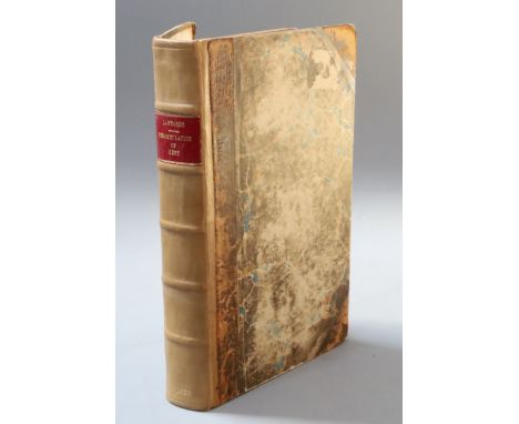
Lambard, William - A Perambulation of Kent, 8vo, with portrait and 1 map, rebacked half calf, title page signed Rob. Dadd, Chatham 1826.Note: Inner fly leaf with manuscript in ink - 'Robert Dadd, a chemist of Chatham, the first owner of this book, was murdered in Halfpence Lane, Cobham, on the 31st August 1843 by his son, Richard, an artist, who had become insane ...'

Lot 30

Dearn, Thomas Downes Wilmot - An Historical, Topographical and Descriptive Account of the Weald of Kent, 1st edition, 8vo, contemporary half calf, repaired, with map and 8 plates, Cranbrook 1814

Lot 32

Fisher, Thomas - The Kentish Traveller's Companion, 4th edition, 8vo, rebacked paper wrappers, with folding road map (Kent Road from London to three miles beyond Rochester), Canterbury 1794

Lot 33

CANTERBURY: Gostling, W - A Walk in and about the City of Canterbury with Many Observations Not Hitherto Described in Any Other Publication, 4th edition, 8vo, half calf with frontis, folding map and 2 plates, Canterbury 1796

Lot 37

THANET AND CINQUE-PORTS: Brayley, Edward Wedlake - Delineations, Historical and Topographical, of the Isle of Thanet and the Cinque Ports, 2 vols, 8vo, rebacked, with marbled boards, with 2 engraved titles, folding map and 106 plates, London 1817-18

Lot 38

CANTERBURY: Gostling, William - A Walk in and about the City of Canterbury, New edition, 8vo, with frontis and folding map (foxed), front board almost detached, Canterbury 1825

Lot 44

MARGATE, RAMSGATE, BROADSTAIRS: Bonner, G.W. - The Picturesque Pocket Companion to Margate, Ramsgate and Broadstairs, 12mo, original cloth with paper titling label on front cover, William Kidd, London 1831 and Mackie, S.J. - Handbook of Folkestone for Visitors, 12th edition, 12mo, with folding map, pictorial paper covered boards, J. Riley, Folkestone [c.1882] (2)

Lot 45

Cooke, George Alexander - Topographical and Statistical Description of the County of Kent, 12mo, rebound calf, with folding map, London [c.1800]

Lot 46

Pinnock, William - The History and Topography of the County of Kent, 12mo, rebound calf, with folding map (torn), London [c.1820] and Black's - Guide to Kent, 8vo, green cloth gilt, folding map, with small tear, 6 plates, London 1876 (2)

Lot 5

Allen, Thomas - The Picturesque Beauties of Great Britain: Kent, contemporary quarter calf - rubbed, with engraved title, folding map and 126 views on 63 plates, lacking front free endpaper, L: George Virtue, [c.1832?]

Lot 51

Bagshaw, Samuel - History, Gazetteer, and Directory of the County of Kent, 2 vols, 8vo, cloth, cover to Vol I detached, joints split and spines cracked to both volumes, lacking folding map, Sheffield [c.1887]

Lot 599

Hermon Moll map of Antego (Antigua) c.1732 and a map of Jersey published by R H Laurie, 1842

Lot 64

CANTERBURY: Somner, William and Battely, Nicholas - The Antiquities of Canterbury, in two parts, the first part, The Antiquities of Canterbury; or a Survey of that Antient City, with suburbs and Cathedral, etc, the second part, Cantuaria Sacra: or The Antiquities Illustrated and Adorned with Several Useful and Fair Sculptures, the second edition, revised and enlarged, tall 4to, old leather scuffed and work, rebacked, with a folding map of Canterbury and 18 additional plates, 4 of which fold out, R. Knaplock, London 1703, S.R. for Samuel Keble, London 1686 printed in Latin and English

Lot 69

Ireland, William Henry - England's Topographer: A New and Complete History of the County of Kent, 4 vols, 8vo, contemporary half morocco gilt, with 1 map, 124 plates, front board and spine of vol 4 detached, London July 1 1828

Lot 7

Greenwood, Christopher - An Epitome of County History, Vol I, County of Kent, 4to, calf, hand coloured with map, frontis, 81 litho plates, foxing to some, London 1838

Lot 70

MAIDSTONE: (Lampreys), S C L - A brief historical and descriptive account of Maidstone and its environs, 1st edition (hardback), small 8vo, rebound half calf, with marbled boards, with double page map and 9 engravings, J Brown, Maidstone 1834

Lot 72

CANTERBURY: Gostling, William - A Walk in and about the City of Canterbury, New edition, 8vo, modern calf, with frontis and folding map, Canterbury 1825

Lot 77

Allen, Thomas - The Picturesque Beauties of Great Britain: Kent, 4to, contemporary half calf, rubbed, with engraved title, 126 views on 63 plates, lacking folding map, George Virtue, London [1832?]

Lot 80

Packe, Christopher - Ankographia sive Convallium descriptio..., 1st edition, 4to, half calf, lacking folding map, latter fore-edge margins damp stained, front board detached, Canterbury 1743

Lot 82

Henshall, Samuel - Specimens and Parts: containing a History of the County of Kent ..., 4to, half calf, with double page folding map, London 1798

Lot 83

Philipottt, Thomas and John - Villaine Cantianum; or, Kent Surveyed and Illustrated. Being an exact Description of all the Parishes, Burroughes, Villages and the Respective Manners ... 1st edition, qto, calf, rebacked, endpapers renewed, folding map from Camden's Britannia by John Norden, engraved by William Kip, inserted, William Godbid, London 1659

Lot 85

Grose, Francis - The Antiquities of England and Wales, Vol 3 only, 4to, tree calf, boards detached, text and plates spotted, with folding map of Dover Castle, Hooper and Wigstead, London [1886?]

Lot 88

Oulton, Walley Chamberlain - The Traveller's Guide; or, English itinerary; containing accurate and original descriptions of all the counties, cities, towns, villages, hamlets, &c. and their exact distances from London, 2 vols, 12mo, calf, rebacked red leather, with 66 engraved views, map of England and Wales inserted in vol I, James Cundee, London 1805

Lot 89

Cooke, George A and Brewer, J.N. - Walks Through Kent; Containing a Topographical and Statistical Description of the County, and of the Isle of Thanet, in Particular. To Which is Prefixed a Copious Travelling Guide Exhibiting the direct and principal Cross Roads, Inns, Distances of Stages, 12mo, quarter morocco, folding map and 20 full page engraved plates, Sherwood, Neely and Jones, London 1819

Lot 9

Harris, John - The History of Kent, 1st edition, Vol 1 (all published), folio, rebound half calf, only 2 plates (of 42), lacking portrait frontis and folded map, title page and dedication repaired at foot, London 1719

Lot 90

Bagshaw, Samuel - History, gazetteer, and directory of the county of Kent, comprising a general survey of the county and the sees of Canterbury and Rochester, 2 vols, 12mo, embossed maroon cloth, folding coloured map in vol 2, Sheffield 1847

Lot 98

Henshall, Samuel and Wilkinson, John - Domesday, or an actual survey of South - Britain, by the Commissioners of William the Conqueror, completed in the year 1086 ... Counties of Kent, Surrey and Sussex ..., qto, half calf, double page map, Bye and Law, London 1799

Lot 99

RICHBOROUGH: Battely, Joanne - Antiquitates Rutupinae [Antiquities of Richborough], 1st edition, rebound half calf, (Archdeacon of Canterbury 1688-1708), Latin text with 4 fold out plates to the rear and 3 vignettes, 1 of the plates is a folding map showing the Isle of Tanatis [Thanet], E. Theatro Sheldoniano, Oxford 1711.

Lot 459

A.E. MORRIS (EARLY 20TH CENTURY ENGLISH SCHOOL) Passenger liner Orotava, watercolour, signed lower right 24.5cm x 35.5cm together with a coastal view, a map of Denmark and a decorative print of sheep (4)

Lot 763

AN ANTIQUARIAN MAP OF BERKSHIRE drawn from the Best Authorities by Thomas Bowen, 15cm x 20cm and one other map of Northamptonshire, engraved for Moules English Counties by James Bingley, 27cm x 21cm (2)

Lot 187

A selection of mirrors including printed map design

Lot 200

A LATE 19th CENTURY MAP OAK CHEST, crossbanded, with solid brass handles, English, with an assortment of five long drawers to the centre and flanked by three short drawer, 68.50" x 26" (174 x 65cms)Provenance: Patricia Downey Design Associate

Lot 2143

Assorted Circa 1950s and Later Gentlemen's Evening Jackets, Shirts and Separates, comprising a burgundy velvet jacket with black trims, another similar; navy velvet jacket; pale blue paisley style woven evening jacket with black trims; Burton Tailored blue/black wool blend jacket, straight cropped hem, velvet mount to the collar; John Collier Milium camel coloured Teddy boy long jacket with velvet mounts, similar style jackets in red and grey; Milium blue crushed velvet double breasted jacket with black velvet mounted collar and pockets; Aqua-Mer wool coat with red lining; two brown leather waistcoats, one printed with a map to the reverse; Seine brown wool long sleeved cardigan with tan suede panels to the front; 1970s shirts including Viyella by London Pride (size 40''), Louis Edwards of London cotton shirt and five printed polyester shirts in various colours (20). Burgundy velvet jacket - one replacement button. Blue woven paisley jacket - some dirty areas, bobbling and trim loose. Milium blue crushed velvet jacket - wear to velvet and lining. Waistcoat with map - some light staining. All other items have slight wear.

Lot 438

Map of the world on decorative wooden panel

Loading...Loading...
  • 109198 item(s)
    /page

Recently Viewed Lots