We found 109198 price guide item(s) matching your search

Refine your search

Year

Filter by Price Range
  • List
  • Grid
  • 109198 item(s)
    /page

Lot 681

A Regency period silkwork picture: A New Map of Europe, 1800, worked in coloured silks to an ivory coloured silk ground by M Wilshins, and enclosed by a foliate meander border, 53 x 59cm.

Lot 250

A vintage boxed Universal Map Measurer by G.W. Bacon & Co, 127, The Strand, London

Lot 530

Herman Moll map of Derbyshire, circa 1724, together with Thomas Kitchin Derbyshire, 1748 and Richard Blome Darbie, 1673, (3)

Lot 1201

Emanuel Bowen (1693 - 1767), hand-coloured engraved map - An Accurate Map of the County of Essex, printed for John Bowles & Son, in glazed frame, 58cm x 76cm

Lot 1276

Antique engraved map - The Town and Borough of Colchester, published by W. Keymer, re-published by Swinbourne & Waller, in glazed frame, 55cm x 78cm, together with the original engraved copper plate mounted on a board (2)

Lot 263

After W. Alken, Aylesbury Grand Steeplechase, a pair of hand-coloured prints, visible, 25cm x 42cm; a small map of Leicestershire, After Emanuel Bowen; and two plans of Leicester. (5)

Lot 434

Gay Cary- coloured map of Cheshire, framed and glazed, together with Thomas Higham - coloured engraving 'The View in the Regents Park' framed and glazed (2)

Lot 857

Rare 19th century hand-drawn map of Golders Green, hand-coloured with colour-key to land in the ownership of Cowhouse Farm, Hodford Farm and Golders Green Farm, 29cm x 32cm

Lot 858

Rare mid-18th century hand-drawn Estate map - 'The exact map of the Farm called Cowhouse Farm in the parish of Hendon and County of Middlesex, belonging to Thomas Lewis Esq..' Surveyed by Isaac Massodar of Hendon in September and October 1747, hand-coloured, approximately 47cm x 58cm

Lot 69

Two Art Nouveau Galeries LaFayette Ballon folding Advertising fans, wooden sticks with double paper leaf. One printed with an industrial photograph displaying the production of products for the store, the verso showing a woman removing her mask after dark by Jean-Gabriel Domergue, (26cm). The other advertising the French store through a miniature map printed in the centre, the verso showing an angelic scene of lovers enjoying each others company during no matter rain or shine (24cm) (2)

Lot 36

A rare Pan American World Airways fixed leaf fan, paper leaf and bamboo stick, obverse with legend 'Fly by Clipper to all 6 Continents' with six prints of exotic birds, reverse with 'The Routes of the Flying Clippers' and map of the world (35cm), together with a collection of paper and bamboo/wooden stick mid 20th century air line fans, from North West, two from Philippine Air Lines with paper leaf of the world 'Spanning 2/3 of the world and others etc.

Lot 41

A collection of Air India fixed and folding Advertising fans, including two palmette shape fixed examples Air-India Route map another circa 1960, and other printed Raga Megh Malhar (38cm), a card example (21cm) and another folding plastic fan (17cm) (5)

Lot 116

A 16th century map of Transilvania, copper engraving, 34 x 46 cm

Lot 151

A map of Yorkshire, published Henry Teesdale and Co, Holborn

Lot 623

AN ANTIQUE EMBROIDERED MAP OF THE WORLD 73cm x 40cm together with a map of Berkshire and four decorative oil paintings (6)

Lot 722

AN ANTIQUE HAND COLOURED MAP after John Ogilby depicting the road from Oxford to Darby, 34cm x 45cm

Lot 723

A MAP AFTER RICHARD BLOME depicting the County of Oxford, 32cm x 28cm together with a further map by Blome depicting various British Isles to include Jarsey and Garnsey, 27cm x 36.5cm (2)

Lot 278

CHESTER WILLIAMS, AJLUN CASTLE, JORDAN WATERCOLOUR 20cm x 30cm, Geoff Clarke, garden corner etching 36cm x 17cm, a map of Monmouthshire, a beadwork picture, a map of Jersey and further decorative pictures

Lot 464

AN ANTIQUE MAP BY ROBERT MORDEN OF MONMOUTH with hand coloured decoration, 35cm x 42.5cm together with a map of Worcestershire, a watercolour c.1942 of a bombed out church, a print depicting Moses being discovered by the Egyptian princess (4)

Lot 6A

Hutton, William - Remarks upon North Wales, 8vo, paper boards with frontis and 3 folding plates, damp stained throughout, Birmingham 1803, together with Haining, Samuel - A Historical sketch and Descriptive view of the Isle of Man, 8vo with folding map (torn), library stamps, incomplete Liverpool 1824 (2)

Lot 146

A volume, West,Thomas. A Guide to the Lakes. London: 1799. Seventh edn. With map. Together with two volumes of Cumberland dialect interest and a Lake District souvenir views booklet.staining on book and rebound. 18 prints

Lot 561

John Speed (British, 1552-1629): a 17th century map of Lancaster, dated 1610, later hand-coloured, published by G. Humbell, engraved by Hondius, depicting the county, with the earliest known map of the city and portraits of eight monarchs, in a Hogarth frame. Double sided with text briefly describing the history and topography of the county verso, 39 by 51cm, framed 46 by 58cm.

Lot 562

Jean Rocque (French, 1709-1762): an 18th century map of Rutland, 17 by 21cm, framed 34 by 36cm, together with Robert Morden (British, 1695-1772): a map of Rotelandia, from Camden's Britannia, sold by Swale and Churchill, later hand coloured, 28 by 35cm, framed, 48 by 54cm. (2)

Lot 640

Railwayana: a collection of Victorian to mid 20th century printed ephemera including: a copy of Ports of the LNER 1938, containing compliment's slip from the Dock Superintendent for London and North Eastern Railway, Middlesborough, a copy of Manchester, Sheffield and Lincolnshire Railway, General Instructions, 1890, a copy of Great Northern Railway Distance Map 1897, and a file containing a quantity of railway pamphlets, many advertising fare prices or trips, some tickets, hand written Midland and Great Northern Railways Joint Committee memorandums, 1890s, and way bills. (q)

Lot 1081

A 19th century adjustable piano stool and three ornithological prints and a map of Kent

Lot 1157

A hand coloured map after Christopher Saxton, together with various other prints and pictures

Lot 1179

Emmanuel Bowen, An Accurate Map of Dorset Shire; together with two later maps; an etching after Henry Wilkinson; an etching of Toledo and a further print after William Henderson (6)

Lot 178

Original plan map of the Western District of the Turnpike & State Labour Roads. Map doesn't show a date. Also doesn't show forth bridge or railway lines .

Lot 53

Military helmet, Gas mask with carry bag, Beret hat, Gun holster & Map holder filled with military photos

Lot 878

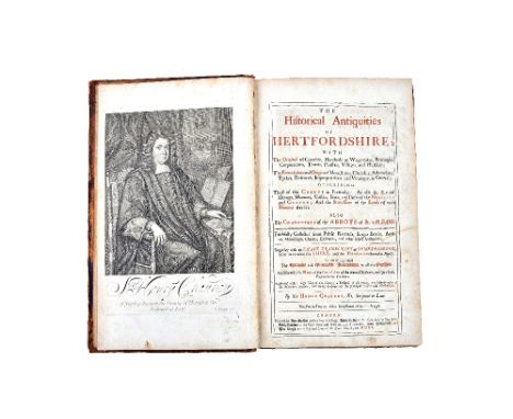
CHAUNCY (Sir Henry) The Historical Antiquities of Hertfordshire . . . First Edition. title printed in red & black, engraved portrait, folded map, 2 folded prospects & 41 other copper-engraved plates (including 34 d-page of county seats, with family armorials); contemp. gilt calf, later rebacked, roy. 4to. 1700. * with the additional table & an engraved portrait of Sir John Brocket; 19th cent. armorial bookplate of Theodore H. Broadhead. Illustrated

Lot 913

BIBLE - King James Version, 1614. [The Holy Bible . . . ] lacks general title (apparently dated 1613), otherwise main text complete, including pictorial N.T. title (1614), the Concordances, the Genealogies (with d-page map), head / tailpiece decorations & some initial letters, additionally some 13 other illustrations, d-col. printing; old calf (defective), 4to. (in 8s). Robert Barker, 1613-14. * the first black-letter quarto edition was published slightly earlier in 1613.

Lot 159

Map of Sussex by J & C Walker, framed and glazed, overall 53cm x 46cm.

Lot 96

'Kent', 17th century map by Robert Morden (British 1650-1703) 35cm x 64cm and five other 18th/19th century maps including Cheshire, Devonshire and Herefordshire max 44cm x 31cm (6) Condition Report Click here for further images, condition, auction times & delivery costs

Lot 141

Sifton Praed & Co Ltd Leather cased set of Maps of England & Wales and another rolled Map

Lot 541

Collection of Twelve Framed and Glazed Pictures including Watercolours, Etchings, Pencil Drawings, Map, Prints, etc

Lot 558

Reproduction Ernest Clegg Coloured Map of Somerset produced for the National Fire Service

Lot 709

Collectors cards including War Bulletin, A&BC Civil War News, mid 20th Century newspapers, one volume, Gone With The Wind and a framed Lancashire map

Lot 339

A British Isles map

Lot 312

Three framed Spy sporting prints together with a framed set of cricket cigarette cards & map of Durham

Lot 48

An Early Coloured Map of Warwickshire by Robert Morden, 37 x 42 cms , together with another similar early coloured map of the County of Monmouth by Robert Morden, 37 x 42 cms

Lot 49

An Early Coloured Map of Leicestershire by Robert Morden, 36 x 42 cms, together with another early coloured map of Worcestershire by Robert Morden, 37 x 42 cms

Lot 50

An Early Coloured Map of Durham by Robert Morden, 38 x 42 cms, together with an early coloured map of Nottinghamshire by Robert Morden, 37 x 42 cms

Lot 51

An Early Coloured Map of Wiltshire by Robert Morden, 36 x 42 cms, together with another early coloured map of Westmorland by Robert Morden, 37 x 42 cms

Lot 52

An Early Coloured Map of Shropshire by Robert Morden, 36 x 41 cms, together with another early coloured map of Gloucestershire by Robert Morden, 35 x 42 cms

Lot 53

An Early Coloured Map of Northamptonshire by Robert Morden, 37 x 42 cms, together with another similar early coloured map of Oxfordshire by Robert Morden, 43 x 33 cms

Lot 54

An Early Coloured Map of Herefordshire by Robert Morden, 37 x 42 cms, together with another similar early coloured map of Rotelandiae, 30 x 37 cms

Lot 58

An 18th Century Coloured Map of Gloucestershire by Robert Morden, 35 x 42 cms

Lot 94

Johnstons Standard Map of the British Empire, a large map within ebonised frame dated 1884, 129 x 156 cms

Lot 454

A map of Suffolk engraved by S.Hall, floral tapestry plus two other pictures

Lot 1085

Pageant of Wakefield and West Riding, Leeds Old and New, 1868 Map of Rochdale, Normanton's Great War, Railway & Transport photos, bus timetables, 1938 Railway Sale Bill Pontefract to London, other publications:- One Box

Lot 1627

C. Goddard, Sheep Grazing, watercolour, signed lower left, 28 x 44.5cm; Harrisons History of London Map, prints, engravings etc. in a folio.

Lot 465

'Postes de France' 1824 - A 255 page bound almanac giving detail of the postal arrangements and costs for France at that time along with table of connecting services to Geneva and Milan, a map of France showing postal routes and other detail useful to using the service - in excellent condition for its age
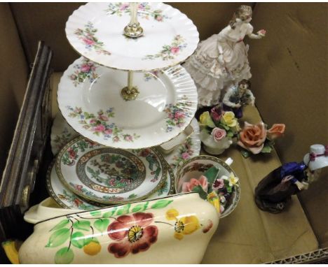
Lot 757

An early 20th century map of Gloucestershire by J Archer - 23 x 18cm

Lot 759

A 17th century map after John Speed of Gloucestershire with the cities of Gloucester and Bristow (Bristol)

Lot 760

An antique Robert Morden map of Surrey - 36 x 42cm

Lot 761

A 17th century map after John Speed of Suffolk dated 1610 with index to glazed verso - 38 x 51cm

Lot 762

A 17th map of the county of Somerset by Richard Blome - 27 x 34cm

Lot 301

AFTER EMANUEL BOWEN "An accurate map of the West Riding of Yorkshire divided into its' wapontakes", coloured engraved map

Lot 53

A collection of various china wares, etc including a Royal Worcester figurine "The Fairest Rose", limited edition No'd. 4185/12500, together with a 20th Century Sitzendorf figure of a woman with parasol, a Sitzendorf figure of a gardener, Goebel Hummel figure of a young boy singing, a pair of Karl Ens rose models, two Coalport posies, a Royal Albert three tier cake stand and George Jones & Sons crescent china tureen and cover, together with a mahogany board decorated with map of The Falklands, a collection of seven coins, circa 1980-1992 and a Coalport trio

Loading...Loading...
  • 109198 item(s)
    /page

Recently Viewed Lots