We found 109182 price guide item(s) matching your search
There are 109182 lots that match your search criteria. Subscribe now to get instant access to the full price guide service.
Click here to subscribe- List
- Grid
-
109182 item(s)/page


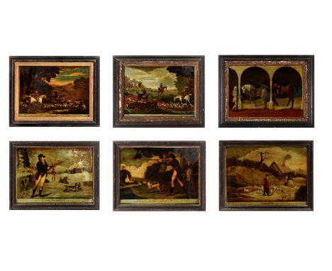
Lot 195
A GROUP OF ELEVEN REVERSE GLASS MEZZOTINTS 18TH AND 19TH CENTURYTo include: 'The Rt Honble Earl of Loudoun', Ramsey Pinxt, Spooner Fecit, 43 x 42.5cm ; 'His Royal Highness Prince Edward &C &C', Morland Pinxt, Richard Houston fecit, 41 x 30.5cm ; 'Maria Countess of Coventry', 47cm high, 37cm wide; 'Pastora', Ryall 7 R. Withy, Fleet Street, 45 x 34.5cm; 'Beating and Trailing for a Hare', J. Seymour invent, T. Burford delin et fecit, 36.5 x 46.5cm; and 6 others, most in period ebonised frames (11) For full list please see our online catalogue condition report.Condition Report: All showing typical 'country house' wear from handling and use to frames in particular with losses to edges, details and surface dirtSizes refer to overall frame size'The Rt Honble Earl of Loudoun', Ramsey Pinxt, Spooner Fecit, 43cm high x 42.5cm wide; 'His Royal Highness Prince Edward &C &C', Morland Pinxt, Richard Houston fecit, 41cm high, 30.5cm wide; 'Maria Countess of Coventry', 47cm high, 37cm wide; 'Pastora', Ryall- R. Withy, Fleet Street, 45cm high, 34.5cm wide; 'Beating and Trailing for a Hare', J. Seymour invent, T. Burford delin et fecit, 36.5cm high'Going to Cover', Published July 14 1794 by John Fairburn, Map, chart and print seller, No. 146 Minories, London, 31cm high, 41cm wide; 'Partridge Shooting', Pubd Dec 1804 by Stamp and Son, 74 Leather Lane, London, 31cm high, 41.5cm wide; (print lifting from glass)'Going Out in the Morning', Published according to act of Parliament, June 20th 1753, J. Seymour invt, T. Burford del et fect, 36cm high, 46.5cm wide, 'Woodcock Shooting', Pubd. Dec 1804 by Stampa & Son, 74 Leather Lane, London, 42cm wide, 31.5cm high; (glass cracked)Two unnamed equestrian prints- Seymour pinxt, T. Burford fec, each 46cm wide, 36cm high. (one frame with upper section detaching and in need of repair) Condition Report Disclaimer
![CARTOGRAPHY; MOLL (HERMAN) (1654-1732) 'A NEW AND EXACT MAP OF THE UNITED PROVINCES OR NETHERLANDS'[London:] printed for H. M](https://cdn.globalauctionplatform.com/040b817b-e05b-4793-addf-ad5a0154eb00/dc1d1ed7-3de1-4de0-b549-ad82010572ff/468x382.jpg)
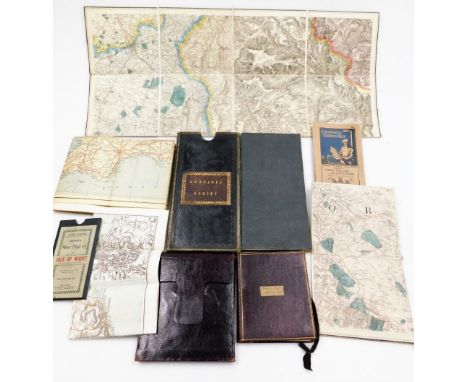
Lot 72
CARTOGRAPHY; MOLL (HERMAN) (1654-1732) 'A NEW AND EXACT MAP OF THE UNITED PROVINCES OR NETHERLANDS'[London:] printed for H. Moll by Midwinter & Bowles, [dated 1710] part hand-coloured, with title cartouche, dedication to "The Right Honourable CHARLES, Lord Viscount Townshend", mounted, framed and glazed 70cm high, 109cm wide overall

Lot 29
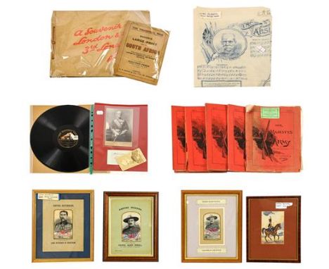
Field Marshall Lord Roberts V.C., a cabinet card by Messrs. Bassano, a carte de visite by the London Stereoscopic Company, an ink signature ''Believe me / yours sincerely / Roberts'', a cotton handkerchief printed with a portrait of Lord Roberts, the music and verse of ''The Absent Minded Beggar'' by Arthur Sullivan and Rudyard Kipling, and an HMV recording of his Address on National Service, Part II, 01084; six Woven Silk Stevengraphs of Lord Kitchener of Khartoum and Colonel Baden Powell, including two from the Empire Makers series and one from the Empire Defenders series; also, a Souvenir of London and the 3rd London General Hospital, which was presented to the staff who treated soldiers 1914-1919, a Bacon's Map of South Africa and fifteen volumes of Her Majesty's Army magazine (qty)


Lot 517
A group of maps and ephemera, to include Bartholomew's Revised Half Inch Contoured map, The Geographica Road Map of South East Yorkshire and North Lincolnshire, The Old Hand Knitters of The Dales by Mary Hartley and Joan Ingoldby, The Shell Touring Map for Scotland, Bradshaw's Street Plan of Sheffield, various other Ordnance Survey, Shell and other road maps for Great Britain and The Royal Atlas of England and Wales by J G Bartholomew. (a quantity)

![Bible [English]. The Bible: Translated according to the Hebrew and Greeke, and conferred with the best translations in divers](https://cdn.globalauctionplatform.com/eb01b961-dd44-4022-93a5-ad8900ff91e1/27bb7263-f360-43c2-86d9-ad8a011f92e2/468x382.jpg)
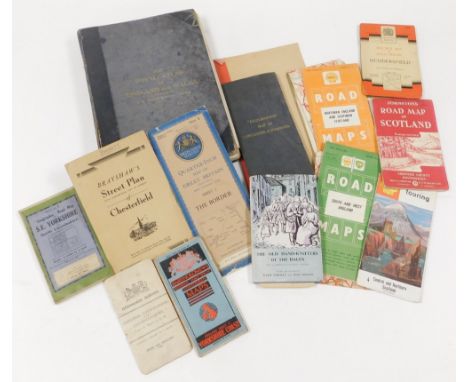
Lot 111
Bible [English]. The Bible: Translated according to the Hebrew and Greeke, and conferred with the best translations in divers languages..., Imprinted at London by Robert Barker, 1615, general title and New Testament titles present, both within decorative woodcut borders, Apocrypha present, double-column black letter text with marginal notes in roman type, lower outer corner of A1 torn with slight text loss and repaired, toning and some light marginal browning, occasional spotting and few marks, light damp staining at head, bound with the Genealogies by John Speed at front (ink marks and manuscript entry to title, without map), and bound with at rear, Two right profitable and fruitful Concordances..., Imprinted at London by Robert Barker, 1615, ink stain to initial seven leaves, bound with, The Whole Booke of Psalmes. Collected into English Meeter, by Thomas Sternhold, John Hopkins, and others..., London: Company of Stationers, 1616, final leaf torn with loss, some cropping to running titles mostly to Concordances & Book of Psalms, four blank leaves at rear with late 17th-mid 18th century manuscript genealogical entries, including "November 25 1671 James Bradley son of John Bradley was baptised" and "my father John Bradley deceased September ye 14 day 1714 in ye 80th your of his age..."later endpapers, contemporary blind panelled calf, rebacked and corners repaired, light wear to extremities, 4to (21 x 16.5 cm)Qty: (1)NOTESHerbert 340; Darlow & Moule 264; STC 2241. Geneva version. Apparently the last black-letter quarto edition of this version printed by Barker. There are two varieties of this date, this example being version A. General title: ... rea | die finding ..., Certaine questions and answers ..., *3 b, 2nd col.: ... be instruc- | ted, assured ...
![Bible [English]. The Holy Bible, containing the Old Testament and the New: Newly translated out of the original tongues: and](https://cdn.globalauctionplatform.com/eb01b961-dd44-4022-93a5-ad8900ff91e1/4717bb08-4429-427e-b3eb-ad8a011f93b5/468x382.jpg)
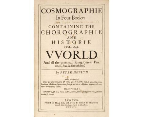
Lot 112
Bible [English]. The Holy Bible, containing the Old Testament and the New: Newly translated out of the original tongues: and with the former translations diligently compared and revised, by his Maiesties special commandement, Imprinted at London by Robert Barker, 1616, general title and New Testament titles present, both within decorative woodcut borders, general title a little close-trimmed at fore-edge and with early ownership inscription to verso 'Robert Collier his booke, March the 31 1695' (ink show-through to recto), long repaired closed-tear to first two leaves of 'Translators to the reader' (a3 & a4), full-page woodcut of Adam & Eve in Garden of Eden (close-trimmed at head & fore-edge, repaired at head & foot and with repaired closed tears), Apocrypha present, lacking blank leaf 4B6 before New Testament title and final blank 4V8, leaf 4E1 guarded, bound with the Genealogies at front (title with ownership signatures), with double-page woodcut map of the Holy Land by John Speed, light toning, occasional marginal finger-soiling and spotting, 18th century calf, gilt decorated spine (faint & without title label), upper board detached, lower joint split, rubbed, extremities worn, folio (32.5 x 21.4 cm)Qty: (1)NOTESHerbert 349; Darlow & Moule 271; STC 2245. The first small folio edition of King James' version; printed in roman type. According to Scrivener (The Authorized edition..., p.17) this was the earliest to receive any considerable revision. The line Appointed... is omitted from both title.
Lot 117
Heylyn (Peter). Cosmographie, In Four Bookes. Containing the Chorographie and Historie of the Whole World, and all the principal Kingdomes, Provinces, Seas, and Isles thereof, 1st edition, 2 volumes, London: Henry Seile, 1652, additional engraved title to first volume (small hole to upper blank margin, dust-soiled, lined to verso), initial titles to both volumes with signature of "John Evelyn [Junior] Durate &c Virg: aen: 1.1", four double-page engraved maps (Europe, Asia, Africa, and Americas), each map cropped to edges with some loss, first volume with ink stain to fore-edge blank margins of leaves 2Q1 & 2Q2 and closed tear to 2Q6, lower outer blank corner of 2S4 torn away, front free endpapers with manuscript press mark D6:8, front pastedowns with armorial bookplate of Sir Frederick Evelyn Bart. and 20th century John Evelyn library 'J.E' bookplate, attractive contemporary speckled calf, with elaborate gilt decorated spines, upper joint of first volume cracked at head & foot, folioQty: (2)NOTESProvenance: John Evelyn, junior (1655-1699), son of John Evelyn, writer, diarist & gardener, 1620-1706; The Evelyn Library, Christie's December 1, 1977, lot 740, where purchased by Desmond Burgess for £200. Wing H1689; ESTC R5447. Books 1-3, the two parts of book 4, and the Appendix each have separate dated title page; register attempts to be continuous. Pagination is separate except for book 4, part 2, which is continuous with part 1.
Lot 165
Carli (Comte Giovanni R). Lettres Americaines, 1st edition in French, 2 volumes, Paris: A Boston, 1788, half-titles, folding map, offsetting, spotting (mostly marginal, a couple of heavier spots to folding map), contemporary sheep gilt, joints rubbed, some abrasions to boards, corners bumped, 8voQty: (2)
Lot 20
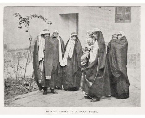
Sykes (Ella). Through Persia on a Side-Saddle, 1st edition, London: A.D. Innes & Company, 1898, frontispiece, 31 photographic plates, ex-library, library ticket to front pastedown, rear endpaper and verso of folding map, hinges cracked, contemporary ownership inscription to title page and one additional leaf, spotting throughout (mostly marginal), publisher's cloth, library number to base of spine, boards stained, spine rubbed, corners bumped, 4toQty: (1)

Lot 26
Blackmore (John). Views on the Newcastle-upon-Tyne and Carlisle Railway, from Drawings by J. W. Carmichael, Currie and Bowman, Newcastle, Thurnham, Carlisle and C. Tilt, London, 1837, decorative title, 22 (of 23) uncoloured engravings on India wove, each with a page of descriptive text and tissue guard, some repaired marginal closed tears and slight creasing, in two parts and retaining publishers paper wrappers, contents washed and repaired, later endpapers, modern half-speckled calf over marbles boards with gilt title to spine, 4to, together with Roscoe (Thomas). Illustrated History of the London and North Western Railway, from London to Birmingham, Liverpool, Manchester &c...., 2 volumes bound in one, George Routledge and Co. 1847, additional half-title, 27 (complete as list) uncoloured engraved views, upper hinge weak, publisher's blind-stamped green cloth, re-backed with later calf gilt title labels to the spine, boards stained, 8vo, with Drake (James, publisher). Drake's Road Book of the Grand Junction Railway from Birmingham to Liverpool & Manchester, published Birmingham, Liverpool, Manchester & London [1837], frontispiece of a folding linear map of the Grand Junction Railway, numerous engraved advertisements and illustrations throughout, publisher's card wrappers, upper cover torn with loss and replaced in facsimile, small 4to, with another seven reference books, catalogues and periodicals, all relating to railways, including Blackwells's Catalogue 865 relating to Transport and Technology and Phillips 1977 catalogue of fine early railway prints, various sizes and conditionQty: (10)
Lot 264
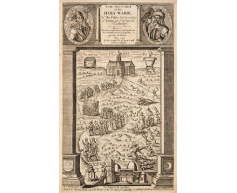
Fuller (Thomas). The Historie of the Holy Warre, 2nd edition, Cambridge: R. Daniel for Thomas Buck, 1640, additional engraved title and folding engraved map by William Marshall (map with small repairs to verso), 'A declaration of the Frontispiece' leaf at front with closed tear and crease, a few leaves with minor marginal repairs, a few marginal wormholes, ownership signature of D.L. Cumming, 19th century sprinkled calf gilt, upper cover detached, spine a little rubbed, folioQty: (1)NOTESSTC 11465.

Lot 273
Dugdale (William, & Dodsworth, Roger). Monasticon Anglicanum, 3 volumes, mixed editions, London: Christopher Wilkinson [et al], 1661-1682, volume 1 with half-title and additional engraved title, 109 engraved plates, after Wenceslaus Hollar and others, 1 folding, many double-page, one single-page plate with 8cm closed tear, folding engraved map of Thanet, with 2 short closed handling tears, titles printed in red & black, decorative woodcut initials, head- and tail-pieces to volumes 2 & 3, 3rd volume with half-page engraving in letterpress, volume 1 with some spotting and toning, a preliminary blank to each volume with ink ownership name, other preliminary blanks with portions torn away, each front pastedown with crest bookplate 'White, Wallingwells', 4 hinges strengthened, contemporary uniform sprinkled calf, worn, rebacked with original spines relaid, volumes 1 & 3 front covers detached, volume 2 front joint cracked, folioQty: (3)NOTESWing D2487A-4-6. Volume 1 is the second edition, volumes 2 & 3 are first editions.
Lot 282
London and Its Environs Described, Containing an account of whatever is most remarkable for grandeur, elegance, curiosity or use, in the city and in the country twenty miles round it... decorated and illustrated with a great number of views in perspective, engraved from original drawings, taken on purpose for this work. Together with a plan for London, a map of the environs and several other useful cuts, 6 volumes, 1st edition, London: Printed for R. and J. Dodsley, 1761, half-title to each volume, 4 folding maps and plans (The Environs, or Countries Twenty Miles Round London, New and Correct Plan of London and Plan of Windsor Castle, and one other), and 76 single-page engraved plates, occasional light spotting, minor marginal browning to endpapers and one or two adjacent leaves, as often, contemporary uniform sprinkled full calf, gilt decorated spines with red and black morocco labels, slightly rubbed with a few joints a little cracked at head (generally a handsome set), 8vo, together with: A New View of London; or an Ample Account of that City, 2 volumes, London: A and J Churchill, 1708, adhesive tape repairs to folding map, armorial bookplate and ownership inscriptions to front pastedown, front hinge of volume 1 cracked, speckled text block, later speckled calf, boards rubbed, front joint of volume 1 cracked, spine rubbed with loss, 8vo with: New Remarks of London: or A Survey of the Cities of London and Westminster, of Southwark and part of Middlesex and Surrey, London: E Midwinter, 1732, damp-staining to some rear leaves, marginal toning to preliminaries, front hinge cracked, spotting, contemporary calf, rebacked, corners repaired, boards and joints rubbed with loss, 8vo Entick (John). A New and Accurate History and Survey of London, Westminster, Southwark, and Places Adjacent, 4 volumes, London: Edward and Charles Dilly, 1766, engraved frontispieces, spotting, contemporary calf, joints rubbed, corners bumped, 8vo and 4 other antiquarian volumes related to LondonQty: (17)
Lot 285
Hunter (Henry). The History of London and its Environs, 2 volumes, 1st edition, London: John Stockdale, 1811, 34 (of 36 as listed) engraved plates, maps and plans (some folding), without the aquatint panorama (not in list), the plan of London and the map of the Country round London (as often), some offsetting and occasional minor spotting, armorial bookplates of Tervoe, front hinges cracked, contemporary half diced calf, worn with some staining, 3 joints cracked, volume 1 with small loss to foot of spine, 4to, together with: A New History of London, including Westminster and Southwark, by John Noorthouck, 1st edition, London: R. Baldwin, 1773, 42 engraved plates, plans and maps (some folding, correct as list), many folding with adhesive tape repairs to versos, two large folding maps with contemporary hand-colouring (one in outline), some worming to blank margins and endpapers, front hinge cracked after endpapers, contemporary sprinkled calf, some wear and stains, front joint cracked, 4to, plus: An Historical Account of the Royal Hospital for Seamen at Greenwich, by John Cooke and John Maule, London: for the authors, 1789, folding engraved frontispiece, 3 engraved plates, some light spotting, title with short central tear, one plate with pale dampstain to upper blank corner, contemporary marbled sheep gilt, some surface loss and minor wear, joints cracked, slim 4toQty: (4)

Lot 3
Beattie (William). Switzerland. Illustrated in a series of views taken expressly for this work by W.H. Bartlett, 2 volumes, London: George Virtue, 1836, additional engraved titles, folding map, 106 steel-engraved plates, a few plates with some toning and stains, scattered spotting, all edges gilt, contemporary green half morocco, joints and edges rubbed, 4toQty: (2)
Lot 34
Gray (George Carrington). Gray's New Book of Roads. The Tourist and Traveller's Guide to the Roads of England and Wales and part of Scotland on an entirely new plan..., Sherwood, Jones and Co., 1824, decorative frontispiece of a toll gate with a horseman paying the toll, with the title 'Gray's Book of Roads on an Entirely New Plan', additional letterpress title and preface, a folding map of England and Wales, 180 pages of tables, 49 (complete as list) engraved maps with contemporary outline colouring, including two folding (Derbyshire and The Isle of Thanet), very slight staining, index bound at rear, modern half calf gilt, 12mo, with Capper (Benjamin Pitts). A Topographical Dictionary of the United Kingdom..., printed for Richard Phillips, 1st edition, 1808, frontispiece of an engraved map of the British Isles with contemporary outline colouring, printed title, 45 engraved maps with contemporary outline colouring, slight spotting, contemporary reverse calf, upper board detached, worn and stained, 8voQty: (2)

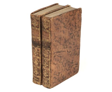
![Africa. Ortelius (Abraham), Africae Tabula Nova, [1570 or later], hand-coloured engraved map, large strapwork cartouche, deco](https://cdn.globalauctionplatform.com/eb01b961-dd44-4022-93a5-ad8900ff91e1/ce175df3-89bb-427d-8b65-ad8a0120237c/468x382.jpg)
Lot 345
Africa. Ortelius (Abraham), Africae Tabula Nova, [1570 or later], hand-coloured engraved map, large strapwork cartouche, decorated with sea monsters and a vignette of a sea battle in the lower right corner, some staining to the margins, slight creasing, 380 x 505 mm, Latin text on versoQty: (1)NOTESMarcel van den Broecke. Ortelius Atlas Maps, 8.

Lot 346
* Africa. Seutter (Matthaus), Africa juxta Navagationes et observat: recentissimas aucta correcta..., Tobias Lotter, Augsburg, circa 1760, engraved map with contemporary outline colouring, uncoloured allegorical cartouche, slight dust soiling, 200 x 260 mm, mounted, framed and glazed, together with Rollos (G.). An Accurate Map of Africa Drawn from the Sieur Robert with improvements, circa 1760, engraved map with contemporary outline colouring, strapwork cartouche, 195 x 290 mm, mounted, framed and glazed, with Rapkin (J.). Africa, J. & F. Tallis, circa 1860, engraved map with contemporary outline colouring, with five uncoloured engraved vignettes, 255 x 335 mm, mounted, framed and glazedQty: (3)


Lot 348
Anglesey & Caernarvon. Saxton (Christopher), Mone Insulae modo Anglesey et Caernarvans duorum borialis Cambriae comitatuum olim vene do cia L. Gwynedhia B. North Wales A, descriptio, Ano Dni 1578 [1579], engraved map with contemporary hand colouring, strapwork cartouche with the royal coat of arms of Elizabeth I and those of Thomas Seckford, the sea decorated with sailing ships, sea monsters and an amorous Neptune in an embrace with Salacia, 355 x 485 mmQty: (1)NOTESThe first printed map of Anglesey and Caernarvonshire, with the bunch of grapes watermark.

Lot 349
Asia. Jaillot (Alexis-Hubert), L'Asie divisée en ses Principales Regions..., 1719, map engraved by Cordier and based on an earlier example by Sanson, contemporary outline colouring, slight dust soiling and wear to the central fold, slight spotting and staining but largely confined to the margins, one repaired marginal closed tear just affecting the printed image, 460 x 640 mm, together with Bellin (Jacques Nicolas). Forsetzung der Karte von dem Mogenlaendischen Ocean die Eylande Sonda die Kusten von Tunquin und China die Eylande Japon die Philippinischen..., 1746, uncoloured engraved map, 290 x 295 mm, with Carte des Isles de Java, Sumatra Borneo &c. Les Detroits de la Sonde Malaca et Banca Golphie de Siam &c. circa 1770, uncoloured engraved map, old folds, small handling tear to the left hand margin, 255 x 295 mm, plus Bowen (Emanuel). An Accurate Map of the East Indies Exhibiting the Course of the European Trade both on the Continent and Islands..., circa 1740, hand-coloured engraved map, old folds, some fraying to the upper margin, 370 x 450 mmQty: (4)

Lot 35
Hermannides (Rutgerus). Historische Landbeschryvinge van Groot-Brittanje ofte Engelandt, Schotlant en Yrlandt, 3rd edition, Rotterdam: Barent Bos, 1685, engraved additional title, 31 engraved folding town plans (correct, including York, not listed), lacks folding engraved map of the British Isles, heavy staining to lower half of signatures C-F and several wormholes similarly affecting D11-E12, the staining heaviest on leaves E5-8 with damage and loss to lower outer corners of E7-8, a little fraying to lower outer corners of first few leaves and a few plates, upper inner hinges broken, contemporary vellum, soiled, small loss to two corners of spine, 12moQty: (1)NOTESThe first edition of this work, in Latin, and with the title Britannia magna, appeared in 1661.
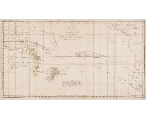
Lot 350
Australasia. Cook (Capt. James & Benard Robert), Carte d'une Partie de la Mer du Sud Contentant les Decouvertes de Vaisseaux de sa Majesté le Dauphin, Commodore Byron, la Tamar, Capitne. Mouats, 1765, Le Dauphin, Capitne. Wallis, le Swallow, Capitne. Cartaret, 1767, et l'Endeavour, Lieutenant Cook 1769, [1774], uncoloured engraved chart of the Southern Pacific Ocean, originally published in a French edition of 'An Account of the Voyages..., in the Southern Hemisphere' old folds, some staining, 360 x 665 mm, together with Le Perouse (Comte Jean de). Carte d'une Partie du Grande Océan a l'E et S.E. de la Nouvelle Guinee..., 1781, uncoloured engraved chart, showing the coastline of North-Eastern Australia, New Guinea, Fiji, Samoa & Tonga, slight creasing, some water staining but confined to the margins and not affecting the printed image, 345 x 495 mm, with Reinecke (Johann Matthais Christoph). Charte von Australien Berichtigt im November 1812, Prague, 1815, engraved map with contemporary outline colouring, old folds, slight staining, three very small holes where old folds cross, bound with eleven uncoloured engravings of Australasian mammals, birds, native costume and costume, several with long closed tears, plus an untitled map of Australia (part of a large scale map) with contemporary outline colouring, with two inset maps of King George III Sound and The Discoveries made by the Ship Duke on the Southern extremity of New Holland, 1791, slight creasing, 430 x 605 mmQty: (4)

Lot 352
Australia. Arrowsmith (John), Eastern Portion of Australia, 1842, engraved map with contemporary outline colouring, inset maps of Tasmania and the Torres Straits, 640 x 510 mm, together with Johnson (Alvin Jewitt & Ward Benjamin P.). Johnson's Australia, New York [1864], engraved map with contemporary hand-colouring, slight spotting and toning, 335 x 400 mm, with Gall & Inglis (publishers). Australian Colonies and New Zealand, Edinburgh, circa 1850, five lithographic maps on one sheet (as published) with contemporary outline colouring, the maps consist of New South Wales, Van Diemens Land, New Zealand, South Australia & Australia Felix, some staining, 490 x 585 mm, plus Bonne (Rigobert). Nlle. Galles Meridle. ou Cote Orientale de la Nouvelle Hollande, circa 1788, uncoloured engraved map, four inset maps of Partie de la Cote de la Nouvelle Galles Meridionale; Esquisse de la Terre Van-Diemen; Baie Botanique; Entree de la Riviere Endeavour, 360 x 245 mm, and Perthes (Justus, publisher). Süd-Östliches Australien. Entworfen u. gezeichnet von F. von Stulpnagel, Gotha, 1850, engraved map with contemporary outline colouring, two inset maps of Tasmania and Western Australia, slight spotting, 325 x 415 mm, with Brion de la Tour (Louis). Carte de Toutes led Nles. Découvertes Dans la Mer du Sud, ou est tracée la Route du Celèbre Captaine Cook dans son dernier Voyage, circa 1790, uncoloured engraved chart of Australasia, old folds,245 x 245 mm, with another five maps of Australasia by Mallet and Murray, various sizes and conditionQty: (11)

Lot 354
Australia. Lindner (F. Ludwig), Karte von Neu Holland nach den neuesten Entdeckungen entworfen und geziechnet, Weimer, [1814 or later], engraved map with contemporary outline colouring, old folds with slight wear where the old folds cross, one fold split and repaired on the verso, slight dust soiling and browning, 345 x 430 mmQty: (1)NOTESThe map was first published in 1814 in Lindner's 'Der funfte Welttheil oder Australien'.
![Australia. Rapkin (John), Australia, Western Australia Swan River, Part of South Australia, Victoria or Port Phillip [and] Ne](https://cdn.globalauctionplatform.com/eb01b961-dd44-4022-93a5-ad8900ff91e1/04a74925-5178-40c4-8669-ad8a01202a31/468x382.jpg)
Lot 355
Australia. Rapkin (John), Australia, Western Australia Swan River, Part of South Australia, Victoria or Port Phillip [and] New South Wales, John Tallis & Company, circa 1855, together five engraved maps with contemporary outline colouring, slight dust soiling to the central folds, map of Western Australia with an additional old fold, each approximately 265 x 335 mmQty: (5)
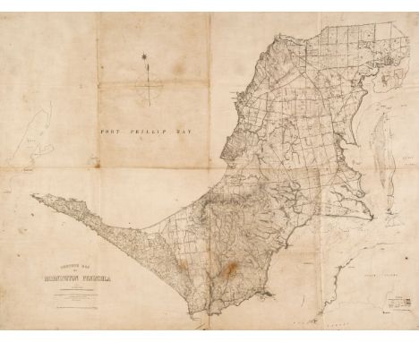
Lot 356
Australia. Slater. (T.), Contour Map of Mornington Peninsula, Melbourne, 1891, uncoloured lithographic map on a scale of 1 inch to the mile, old folds, some staining and dust soiling, small ink library stamp, laid on linen and backed with an early 20th-century colour lithographic map of Northern France, Luxembourg and the Low Countries, 750 x 990 mmQty: (1)
Lot 357
Australia. Wells (W. H. Land Surveyor), A Map of the County of Cumberland in the Colony of New South Wales, Sydney, circa 1860, uncoloured lithographic map, laid on linen, slight spotting and dust soiling, some creasing, numerous repaired closed tears affecting image, 830 x 535 mmQty: (1)NOTESA scarce map centred on Sydney and Botany Bay.

Lot 358
Bartholomew (John). The Imperial Map of England & Wales According to the Ordnance Survey..., A. Fullarton & Co. London & Edinburgh, circa 1870, index and 18 colour lithographic double-page map sheets, slight spotting throughout, all maps re-guarded, later endpapers, contemporary cloth gilt, rebacked with modern repairs to the corners, boards, stained and scuffed, folio, together with Weller (Edward). [Cassells's British Atlas...,] Cassell, Petter & Galpin, circa 1870, lacking title and preliminaries, 100 uncoloured lithographic map sheets of British counties, regions, town plans and railway maps, slight dust soiling throughout, slight water staining, later endpapers, modern blue cloth, folio, with Bartholomew (John, publisher). The Royal Atlas of England and Wales, George Newnes Limited, circa 1900, numerous colour lithographic maps with index bound at rear, contemporary cloth, spine faded, bumped and worn at extremities, folio, plus George Philip & Son (publishers). Philip's Atlas of the Counties of England, 1889, 48 colour lithographic county maps, contemporary half morocco gilt, spine partially lacking, upper board detached, rear board near detached, rubbed and worn, folio, and Letts Son & Co [publishers]. Letts's Popular County Atlas, 1884, title page excised and laid on front blank, preface and index tipped in, 47 colour lithographic maps, text block detached, lacking spine and upper board, rear board detached, folio and Ward Lock & Co (publishers). Nine Motoring & Touring Maps of England and Wales, circa 1930, nine regional colour lithographic maps, each laid on linen, occasional near-contemporary marginalia, a few with crude tape repairs, each approximately 750 x 500 mm, bound in publisher's colour printed wrappersQty: (14)NOTESSold as a collection of maps, not subject to return.

Lot 36
Heywood (John, publisher). The Travelling Atlas of England & Wales with all the Railways & Coachroads, the Cities, Towns, Parks & Gentlemen's Seats Preceded by General Maps of England & North & South Wales. The whole carefully Revised and corrected to the Present Time, circa 1873, forty-four uncoloured lithographic maps, lacking the map of England and Wales, slight spotting throughout, publisher's paper wrappers with the printed calligraphic title to the upper cover, slim 8vo, together with Barclay (Rev. James). The Universal English Dictionary.., J & F Tallis, circa 1855, additional decorative half-title, frontispiece of Buckingham Palace, half-title torn with slight loss, 55 engraved maps by J. Archer, all with contemporary outline colouring, 1 engraved plate and a loosely inserted map of Palestine from another source, some spotting and staining throughout, later endpapers, contemporary calf, re-backed but retaining original spine, 4to, with Hall (Sidney). A Travelling Atlas of the English Counties, Chapman and Hall, circa 1865, title page torn with some loss, laid on later paper, 46 (complete as list) engraved maps with contemporary outline colouring, some spotting throughout, boards bowed, contemporary cloth, rebacked, 8vo, plus Townsend (Leonard). An Alphabetical Chronology of Remarkable Events..., circa 1850, numerous uncoloured engraved plates, and 58 uncoloured engraved maps by J. Archer bound at the rear, some spotting throughout, later endpapers, modern blue cloth gilt, 8vo, with another 6 atlases similar, including examples by Reynolds, Philips, Encyclopaedia Britannia and Stanford, all 8vo, various conditionQty: (10)
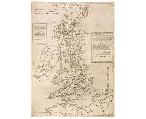
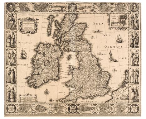
Lot 361
British Isles. (Bertelli Ferrando & Lily George), Britania Insula quae duo Regna continet Angliam et Scotiam cum Hibernia Adjacente, Venice [1562], uncoloured engraved map, two engraved tablets containing descriptive text, one very short marginal tear repaired on verso, 480 x 350 mmQty: (1)NOTESR. W. Shirley. Early printed Maps of the British Isles, 70. A scarce 'Lafreri' map, based on George Lily's earlier 1546 publication (Shirley no. 41) and which is widely attributed to the engraver Paolo Forlani (David Woodward). The map has slightly less topographical information and the cathedral towns are no longer highlighted by a cross and the north and south cardinals are placed inside the map borders. Rare.
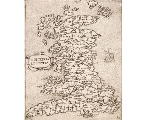
Lot 362
British Isles. Camocio (Giovanni), Inghilterra et Scotia, F. Bertelli, Venice 1575, uncoloured engraved map, one small hole in the upper margin, very slight abrasion to the printed surface, trimmed to the neatline on the left-hand vertical margin, 220 x 180 mmQty: (1)NOTESR. W. Shirley. Early Printed Maps of the British Isles, 105. The second state (the first being published in 1572) and derived from George Lily's map. This edition has the number '82' added to the lower right corner. Originally published in the 'Isole famose porti, fortezze e terre maritime sotto poste...'. Uncommon.
![British Isles. Custodis (David), Angliae, Scotiae et Hiberniae Britannicarum Insularum, Frankfurt [1627], uncoloured engraved](https://cdn.globalauctionplatform.com/eb01b961-dd44-4022-93a5-ad8900ff91e1/696be524-3eca-49fa-89ee-ad8a01202fa0/468x382.jpg)
Lot 363
British Isles. Custodis (David), Angliae, Scotiae et Hiberniae Britannicarum Insularum, Frankfurt [1627], uncoloured engraved map, orientated to the east and decorated with a strapwork cartouche, mileage scale and a compass rose, slight creasing, 270 x 315 mmQty: (1)NOTESR. W. Shirley. Early Maps of the British Isles, 396. A rather naive map by the little known David Custodis which appears to be based on Abraham Ortelius's map of 1570. The map appears in 'Laurea Austrica..., Typus Erasmi Kempffen'.
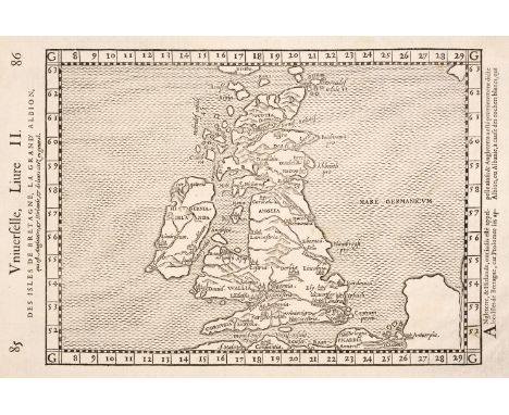
Lot 364
British Isles. De Belleforest (Francois & Ruscelli Girolamo), Des Isles de Bretagne, La Grand' Albion qui est Angleterre & Hirlande & de leurs citez en General, Paris [1575], uncoloured woodcut map, map size 190 x 255 mm, French text to the vertical margins and on the verso of the mapQty: (1)NOTESR. W. Shirley. Early Printed Maps of the British Isles, 112. Originally published in 'La Cosmographie Universelle de tout le monde. Augm[entée] ornée et enrichie par Franc. De Belle-Forest..., chez Michel Sonnius'. The map is a direct copy from Girolamo Ruscelli's Venetian version of Ptolemy's 'Geographia' in 1561.
![British Isles. De Jode (Cornelis), Angliae Scotiae et Hibernie Nova Descriptio, Antwerp [1593], uncoloured engraved map orien](https://cdn.globalauctionplatform.com/eb01b961-dd44-4022-93a5-ad8900ff91e1/bb31a9e4-f4d5-4569-8cf9-ad8a0120316b/468x382.jpg)
Lot 365
British Isles. De Jode (Cornelis), Angliae Scotiae et Hibernie Nova Descriptio, Antwerp [1593], uncoloured engraved map orientated to the east, strapwork cartouche with an additional cartouche containing explanatory text, extensive near-contemporary ink marginalia listing principal cities and towns, some faint near-contemporary underlining of some towns and cities, 350 x 500 mm, Latin text on the versoQty: (1)NOTESR. W. Shirley. Early Printed Maps of the British Isles 1477 - 1650, 173. First published in 1570, this later edition of Gerard De Jode's map was published by his son, Cornelis. in his 'Speculum Orbis Terrae..., Heredu Gerardi de Judaeis' in 1593. Neither the 1570, the 1578 nor the 1593 editions of the atlas sold well. Cornelis died at the early age of 32 and his plates were acquired by Joan Baptista Vrients - who had already purchased Ortelius's plates - thus giving him a virtual monopoly of the publication of maps and atlases in Antwerp. Vrients much preferred the Ortelius plates, and this virtual suppression of de Jode's plates coupled with the poor initial sales of the De Jode atlases results in them being uncommon in the market today.
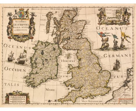
Lot 366
British Isles. Hondius (Henricus & Le Roy Henry), Novissima Descriptio Angliae, Scotiae et Hiberniae [with additional imprint] A Paris chez Michael van Lochon graveur et Imprimeur du Roy Henry Le Roy fecit, Paris [1639], hand-coloured engraved map, inset map of the Orkney Islands, large decorative cartouche and mileage scale, slight mount staining, margins slightly chipped, 380 x 510 mm, no text on the versoQty: (1)NOTESR. W. Shirley. Early Printed Maps of the British Isles, 493. A rare map, engraved by Michel von Lochom. The map appears to have been a separate publication and is only occasionally found in composite atlases. We have found records of only two copies, one in the British Library and one in the Bibliothèque Nationale.
![British Isles. Marelli (Michel Angelo), Ragione Vol Forma et Vera Postura Del' Isola di Ingliterra, Ancona [1579 - 1580], unc](https://cdn.globalauctionplatform.com/eb01b961-dd44-4022-93a5-ad8900ff91e1/a9ee21a9-413e-424d-9eb2-ad8a012032d5/468x382.jpg)
Lot 367
British Isles. Marelli (Michel Angelo), Ragione Vol Forma et Vera Postura Del' Isola di Ingliterra, Ancona [1579 - 1580], uncoloured engraved miniature circular map, with eight cardinal lines radiating from the centre, map diameter 85 mm, size to plate mark (including the title) 130 x 85 mm, Italian text on versoQty: (1)NOTESR. W. Shirley. Early printed Maps of the British Isles, 124. Originally published in Francesco Ferretti's 'Diporti Notturni...,'. An unusual little map in that it entirely omits the island of Ireland and is orientated with west to the top. Ferretti's atlas is dated 1579 in the title but 1580 in the colophon.
![British Isles. Ptolemy (Claudius & Berlinghieri Francesco), Tabula Prima d Europa, Florence [1482], uncoloured engraved m](https://cdn.globalauctionplatform.com/eb01b961-dd44-4022-93a5-ad8900ff91e1/4d572081-49f3-4ef6-a48d-ad8a01203391/468x382.jpg)
Lot 368
British Isles. Ptolemy (Claudius & Berlinghieri Francesco), Tabula Prima d Europa, Florence [1482], uncoloured engraved map on thick laid paper, a few professional repairs to the verso, largely confined to the margins, size to plate mark 405 x 525 mm, sheet size 430 x 555 mmQty: (1)NOTESR. W. Shirley. Early printed Maps of the British Isles, 3, state 1. "an elegant copperplate engraving originally attributed by Hind to Francesco Roselli, an attribution now questioned in view of Roselli's absences from Italy in the period 1480 - 1482. This is the only edition in which the projection follows Ptolemy's original grid, based on equidistant parallels and meridians. The place names are directly engraved on to the plate in Italian, using a lighter and slightly cursive upper and lower case print, compared to the heavier capitals on the Rome plates and the crude lettering on the first Bologna edition". Rare. One of the first available printed maps of the British Isles.
Lot 369
British Isles. Visscher (Claes Janzoon), Tabula Magnae Britanniae Continens Angliam Scotiam et Hiberniam nupperime edita oer Niccolaum Johannis Visscher, Amsterdam [1623], uncoloured engraved carte-a-figures map with 12 oval vignettes of principal cities along the horizontal margins and 10 pairs of costumed figures to the vertical margins, inset map of the Orkney Islands, trimmed to neatline along the left-hand vertical margin, trimmed with slight loss to the strapwork margin along the upper horizontal margin, thread margins to the remainder, old fold, central fold and old folds strengthened and repaired on the verso with slight loss to the printed image, occasional marginal repaired closed tears, 460 x 555 mmQty: (1)NOTESR. W. Shirley. Early printed Maps of the British Isles, 384. A highly decorative and rare map by Claes Visscher (under his Latinised name of Nicolaus Joannis Visscher) and separately published. An example of the first state, engraved by Abraham Goos. It appears in a rare 1623 Mercator atlas, but Shirley suggests that the map may have been issued separately prior to the 1623 atlas.
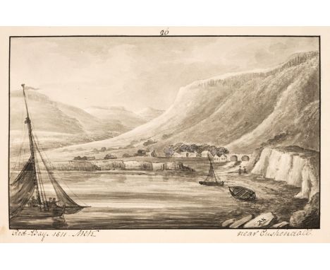
Lot 37
Kerr (Lord Mark Robert) Hamilton (William). Manuscript Copy of Letters concerning the Northern Coast of the County of Antrim. Containing a Natural History of its Basaltes: with an Account of such Circumstances as are worthy of notice respecting the Antiquities, Manners and Customs of that Country, 164pp, map, frontispiece and 51 original grisaille watercolours by the artist, each signed with his monogram, manuscript pages, offsetting, occasional marginal spotting, bookplate of Lord Kerr to front pastedown, contemporary full brown morocco gilt with floral embellishments to turn-ins, gilt text block, boards rubbed, spine extremities and joints worn, corners bumped, 4toQty: (1)NOTESA sumptuous manuscript copy of a cornerstone of 18th century Irish topography. Lord Mark Robert Kerr was Vice-Admiral of the Royal Navy (1837-1840) and an artist. He commanded the Fisgard in the Napoleonic War and it was he who alerted the Royal Navy to the movement of the French fleet through the Strait of Gibraltar in 1805, this being the initial advice that they were at sea. He maintained close correspondence with Admiral Nelson and Nelson thought of him highly; "..I fear Lord M Kerr is falling into the same complaint [as I have]. I have now got him to the fleet and shall keep an Eye upon him for he is too valuable an Officer and good a Man to be lost for want of care" (Nelson, the New Letters, 2005, pp.304). However, he was also an artist of high regard. "What Nelson did not know, however, was that, in addition to being an excellent naval officer, Kerr was also an exceptionally interesting artist: a Regency surrealist" (British Art Journal, Vol 6, No 2 pp.28-30). He married Charlotte MacDonald, Countess of Antrim in 1799 which no doubt contributed to his desire to create this work. Beautifully illustrated with 51 watercolours, all signed by the artist, based upon the corresponding passages in Hamilton's work. The passages of the text have been handwritten (presumably by Kerr) in a fine, flowing hand. Furthermore, the map and two further manuscripts were contributed by his daughter Letitia Louisa Kerr.
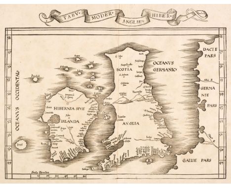
Lot 370
British Isles. Waldseemüller (Martin), Tabu Moder Angliae & Hiber, editors Gaspar & Melchior Treschel, Lyons, 1535, uncoloured Ptolemaic woodblock map, title displayed in a 'ribbon cartouche' above the map, very slight staining, 325 x 410 mm, no text on versoQty: (1)NOTESR. W. Shirley. Early Printed Maps of the British Isles, 25. Originally published in Claudii Ptolemaei..., Geographicae..., Lugduni ex officina Melchioris et Gasparis Treschzel fratum MDXXXV'. Note the mythical island of Brazil on Ireland's southwest coast.
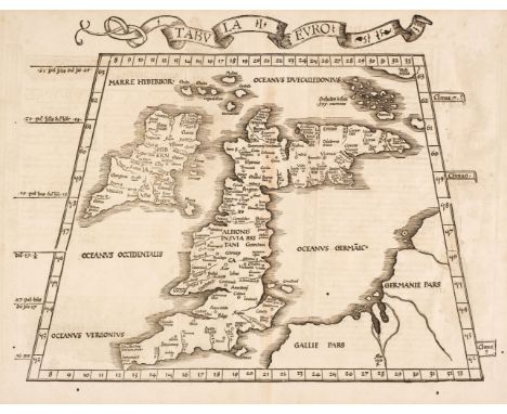
Lot 371
British Isles. Waldseemüller (Martin), Tabula I Euro, Johannes Gruninger, Strasbourg, 1522, uncoloured woodblock on a trapezoidal projection, slight staining and text show through, slight worming, mostly confined to the margins but with two holes affecting the image, slight toning, 335 x 440 mm, Latin text on verso contained within elaborate Renaissance woodcut panels attributed to Albrecht DürerQty: (1)NOTESR. W. Shirley. Early Printed Maps of the British Isles, 15. A Ptolemaic map which has been re-drawn and reduced in size by about 25% -with some minor alterations to the lettering - of an earlier Waldseemüller map of 1515 (Shirley 10). originally published in "Claudii Ptolemaei Alexandrini..., Joannes Grieninger civis Argentoraten". The authorship of this map is sometimes attributed to Lorenz Fries.
Lot 372
British Isles. Waldseemüller (Martin), Tabula nova Angliae & Hiberniae, Lorenz Fries, Vienne, 1541, uncoloured Ptolemaic woodcut map, slight toning to the central fold, slight marginal staining, 300 x 415 mm, no text on versoQty: (1)NOTESR. W. Shirley. Early Printed Maps of the British Isles, 31. The final issue of Waldseemüller's 'modern' map is based upon a reduction of his 1513 map (Shirley 16). Note the mythical island of 'Brazil' situated on Ireland's southwest coast.


Lot 374
Cary (John). Cary's New English Atlas Being a Complete Set of County Maps from Actual Surveys..., 1st edition, 1809, double-page letter press title, index excised and pasted to the first front blank, general map of England & Wales and 43 (only of 45) engraved maps, all with contemporary outline colouring, Yorkshire folding and on two sheets, index bound at rear, some marginal fraying, slight spotting, staining, creasing and dust soiling throughout, later endpapers, modern half calf gilt, rubbed and worn, folioQty: (1)NOTESChubb CCCXXXIII. This atlas was issued in parts between 1801 & 1809 and the maps have a variety of imprints depending on their date of issue. Sold as a collection of maps, not subject to return. Lacking Devon and Kent.

Lot 375
Denbigh & Flint. Saxton (Christopher), Denbigh ac Flint duorum olim Cambriae, modo Walliae comitatuum descriptio, Admo 1577 [1579], map engraved by Remigius Hogenberg with contemporary hand colouring and some later enhancement, slight dust soiling to the margins,slight staining and spotting, 345 x 485 mmQty: (1)NOTESThe first printed map of Denbigh and Flint, with the 'bunch of grapes' watermark.


Lot 378
Dodsley (Robert and Cowley, John). The Geography of England: Done in the Manner of Gordon's Geographical Grammar....., also a Separate Mapp of England, of the Roads, of the Channel and a Plan of London, 1st edition, published R.Dodsley, 1744, frontispiece of a folding engraved map of England & Wales, engraved title, preface and introduction, 49 (of 51) uncoloured engraved folding maps, lacking maps nos. 2 & 3 (A Correct Chart of the English and St George's Channels etc. [and] A New and Correct Map of the Roads of England), toned throughout, later endpapers, modern calf gilt, 8voQty: (1)NOTESChubb. CLXXXI. The map of London described on the title page is also lacking, but this is not uncommon. The British Museum copy also lacks this plan and it is not called for by Chubb. Sold as a collection of maps, not subject to return.
-
109182 item(s)/page