We found 109198 price guide item(s) matching your search
There are 109198 lots that match your search criteria. Subscribe now to get instant access to the full price guide service.
Click here to subscribe- List
- Grid
-
109198 item(s)/page


Lot 268
ENOLA GAY: A large signed printed 18 x 14 colour chart, by Paul W. Tibbets (1915-2007, American Brigadier General, pilot of the Enola Gay), Thomas W. Ferebee (1918-2000, American Colonel, bombardier of the Enola Gay) and Theodore Van Kirk (1921-2014, American Major, navigator of the Enola Gay) individually, the chart being a facsimile copy of the Navigator's Log of the Enola Gay, displaying three sections of the log, detailing in timed intervals the mission to deliver the atomic bomb on Hiroshima, 6th August 1945, and with a short piece of text and a map explaining the mission superimposed over the log. Signed by each of the crew membersin bold blue ink with their names alone to the foot, above a printed title bearing their role during the mission. With a tear to the upper right corner and left edge, not affecting the text or signatures, otherwise VG
![[JAMES JIMMY]: (1915-2008) British R.A.F. Officer, survivor of The Great Escape, 24th-25th March 1944. Selection of unsigned](https://cdn.globalauctionplatform.com/d954ca6f-9d72-4c90-881f-a88c00a2e129/6a2e30e7-3a84-4518-9eaa-7145640c73c8/468x382.jpg)
Lot 260
[JAMES JIMMY]: (1915-2008) British R.A.F. Officer, survivor of The Great Escape, 24th-25th March 1944. Selection of unsigned videos, magazines, colour 4 x 6 photographs (8) and some larger (8) etc., including a membership card for the Royal Air Forces Association, made out to James, June 1980, a printed map titled Ubersichtskarte zum Kursbuch der Deutschen Reichsbahn, dated 1975, a copy of Chowkidar, Spring 2008, the magazine for the British Association for Cemeteries in South Asia, featuring an article on James' book High Noon of Empire, photographs from James' funeral and others depicting James, a copy of the magazine Die Nationalrevolutioare Bewegung 'Widerstand', 1977 (in German), an unsigned Agreement and Contract with the Canadian Bank of Commerce made out to James, 10th September 1935, a video entitled Just a Flying Hat, an audio book of Moonless Night (with one tape missing), an R.A.F. tunic button, a small selection of school and first aid certificates made out to Madge Tughan etc. With some signs of age wear, generally VG to EX, 34Madge Tughan, the wife of Jimmy James.

Lot 261
JAMES JIMMY: (1915-2008) British R.A.F. Officer, survivor of The Great Escape, 24th-25th March 1944. A holograph 22 x 25 map depicting Germany and Central Europe 1939-45, being one of the maps used in James' lectures regarding his imprisonment and escapes during World War II. The map features the borders, rivers, towns and cities of the major central European countries all drawn and written by James in various coloured inks. The map also features the names of the significant POW and Internment Camps within the 3rd Reich, including Dachau, Flossenburg, Sachsenhausen etc., with Stalag Luft III placed at the maps centre. Attached to a rod at the head, with strings that enable the map to be hung. Accompanied by an unsigned colour 5 ½ x 8 photograph, the image depicting the elderly James in a three-quarter length pose shaking hands with an R.A.F. Officer, both men being flanked by maps, one similar to that being sold in this lot. The map has light overall creasing, minor tears to the edges and a larger torn area at the bottom right corner. G to VG, 2


Lot 7
Water colour depicting Penn Common by Frank Gibbons (1852-1918), Victorian Rankin print in birds eye maple frame, 3 framed Sundorne Castle (1900) Photos, 1843 O.S map print of Drayton-In-Hales (Market Drayton) and colour rural print Unfortunately we are unable to do condition reports and extra images for our Interiors Sale

Lot 1352
A Collection Of Pocket/Folding Maps And Guides Fourteen items in total to include A1 Street Atlas Greater Manchester, Johnston's Lake District 2 Miles To 1 Inch Map, vintage Esso London Road Map no.1. Also, the All London Bus Guide, August 1994, and Bartholomews Revised Half Inch contoured map, North Lancashire. Also, hardback 'Newnes Motorists Touring Maps And Gazetteer 1953' and 1952 OS Liverpool map, OS 1961 Blackburn & Burnley map and OS Lake District tourist map.

![[MAPS]. DEVON Saxton, Christopher (c.1540-c.1610), & Kip, William (fl. 1585-1618), 'Devoniae Comitatus vulgo Den: Shyre quam](https://cdn.globalauctionplatform.com/ebdd3c20-9b7e-4073-acde-a86401140e5e/3a032fb5-b432-4e79-cd9d-f20d63b21eb5/468x382.jpg)


Lot 10
Europe.- Wells (Edward) A New Map of Present Spain & Portugal; A New Map of France, two maps from the atlas produced by Wells to celebrate William the Duke of Gloucester's studies at Oxford University, engravings, both good impression, on thin laid paper without watermarks, each approx. 375 x 495 mm. (14 3/4 x 19 1/2 in), with full margins, original folds and handling creases, minor surface dirt, some spotting and browning, unframed, circa 1700.

Lot 102
Agriculture.- Boys (John) A General View of the Agriculture of the County of Kent, folding hand-coloured engraved frontispiece map, 2 engraved plates, folding letterpress table, errata f. at end, without half-title, light offsetting to title, occasional spotting, original wrappers, spine worn, but holding firm, Easton Neston Library label, [Goldsmiths', 16572; Perkins 208], printed for G. Nicol, Pall-Mall, Bookseller to His Majesty, and the Board of Agriculture, 1796 § [Young (Arthur)], "Secretary to the Board". General View of the Agriculture of the County of Suffolk, half-title, folding hand-coloured engraved frontispiece map, 2 folding engraved plates, binder's directions f. at end, offsetting to title, occasional spotting, Easton Neston Library label, original wrappers, printed by B. Macmillan, for G. Nicol; and sold by G. G. and J. Robinson, 1797; and 4 others, Agriculture, 8vo (6)
Lot 108
Naval.- Dundonald (Thomas, tenth Earl of) The Autobiography of a Seaman, 2 vol., 4 folding charts, pencil inscription and ink-stamp of Admiral Sir A. Phillimore to front free endpaper, occasional spotting, newspaper clipping pasted to blank prelim (vol. 1), a little damp-staining (vol. 2), hinges strengthened with tape, cracked hinges, original cloth, slight bumping to corners and extremities, faded spines, 1860 § Guppy (Henry Brougham) The Solomon Islands and their Natives, first edition, map, plates and illustrations, spotting, cracked hinges, bookplate of the Seaman's Library of H.M.S. Orlando, later cloth with 'Ship Store Royal Navy' blindstamped to upper cover, rubbed and a little soiled, 1887; and another, similar, 8vo (4)
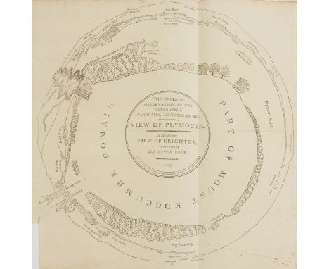
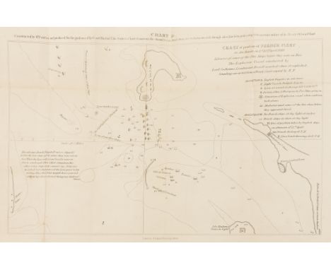
Lot 118
The Leicester Square Panorama.- Plymouth.- Adlard (J.), Publisher. The Circle of Observation in the Lower Room, Panorama, Leicester-Square. Representing a View of Plymouth, A Beautiful View of Brighton is now in The Upper Room, an original diagram and souvenir of the installed panoramic exhibition, engraving on laid paper with watermark of 'P. Halford' dated '1795', sheet 315 x 320 mm. (12 3/8 x 12 1/2 in), small loss to lower left corner, folds, unframed, 1797; together with a 19th century pen and ink manuscript map illustrating the English Channel, and approximately 50 topographical prints of the British Isles, etchings, engravings, aquatints, some with hand-colouring, various sizes, between 125 x 190 mm. (4 7/8 x 7 1/2 in) and 250 x 300 mm. (9 7/8 x 11 3/4 in), occasional surface dirt, spotting and browning, all unframed, (52).

Lot 15
Middle East.- Chardin (Sir John) Journal du Voyage du Chevalier Chardin en Perse et aux Indes Orientales, second edition, engraved additional pictorial title, head-piece to dedication, portrait, folding map and 11 folding plates only (of 15, lacking plates of Sultanié, Kom, Sepulchres d'Abbas & Sophie), all mounted on stubs, one plate loose, slight worming from V2 to end with some loss and affecting 2 plates, old ink signature of Mary Oldnall on front free endpaper, contemporary calf, spine gilt with red roan label, rubbed, joints split, spine ends worn, 12mo, Amsterdam, Abraham Wolfgangh, 1686.

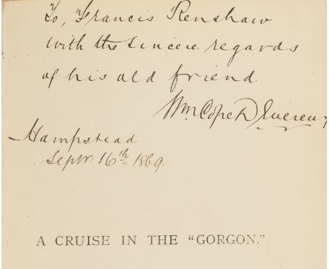
Lot 2
Africa.- Slavery.- Devereaux (W. Cape) A Cruise in the "Gorgon" ... , first edition, signed and inscribed by the author, folding colour map frontispiece, pencil annotations, occasional very faint spotting, new endpapers, contemporary half calf, small label affixed to spine foot, 'Cruising Library Association' gilt stamped to upper cover, rubbed, [Czech, p.48], 8vo, 1869.
Lot 24
Birmingham.- Colby (Lt. Col. Thomas) Ordnance survey maps showing Birmingham and its environs, two sheets, numbers LXIII N.W. and LIII N.W., lithographs, with some hand-colouring, each sheet approx. 650 x 1130 mm. (25 1/2 x 44 1/2 in), both dissected and mounted on linen, folding with purple coloured endpapers and labelled 'North' and 'South' accordingly, presented in contemporary gilt-tooled slipcase, corners scuffed, worn, 8vo, 1831; Colby (Lt. Col. Thomas) Ordnance survey map centred on Birmingham, sheet no. LXII S.E., lithograph with hand-colouring, 650 x 810 mm. (25 1/2 x 31 7/8 in), dissected and mounted on linen, folding into mottled green envelope-style slipcase, rubbed, 8vo, 1831 § Richmond (George), publisher. Reduced Ordnance Survey around Bewdley, covering Worcestershire, Herefordshire, and parts of Radnorshire, Shropshire, Gloucestershire, and Warwickshire, lithographed map with some hand-colouring, 995 x 1305 mm. (39 1/4 x 51 1/4 in), dissected and mounted onto linen, some light surface dirt, folding with marbled endpaper into original cloth covered boards, gilt label on upper cover, worn, 4to, circa 1870s, (3).
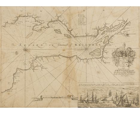
Lot 26
Bristol and Bath.- Collins (Capt. Greenville) Printed chart of the Bristol Channel from Chepstow and Bristol to Broad Haven and Boscastle, with vignette lower right showing the arrival of William III to 'King Road', compass rose and rhumb lines, and decorative coat of arms centre right, engraving, 430 x 560 mm. (17 x 22 in), central vertical folds, handling creases, laid onto antique paper support with early graphite drawing verso, unframed, c. 1693; together with a group of seven other maps and plans of Bristol and Bath, including a [?]19th century manuscript pen and brown ink map of Bristol and its surrounds, presumably intended as a book illustration, and with Mathew's 'New & Correct Plan of City and Suburbs of Bristol', 1815, Gibbs' 'A New and Correct Plan of the City of Bath', Barratt & Son's 'A New and Correct Plan of the City of Bath', 1817, and with Waterlow and Sons' 'Map of the Country & of the Railways Existing and Proposed in the Districts situated between Bristol, Exeter & Dorchester', engravings, lithographs, various sizes, largest 560 x 725 mm. (22 x 28 1/2 in), occasional handling creases, tears and surface dirt, all unframed, [mainly 18th and 19th century], (8).
Lot 27
British Isles.- Camden (William) Camden's Britannia, Newly Translated into English with Large Additions and Improvements... by Edmund Gibson, engraved portrait frontispiece by R. White, 8 plates of coins and 50 maps by Robert Morden, 2 folding (Kent & Norfolk) and the rest double-page mounted on stubs, engraved and woodcut illustrations, one or two full-page, lacking D4 (columns 61-64), both folding maps a little torn and repaired, first plate of coins trimmed and reinforced at inner margin, slight worming to head-lines of 4D-4H just affecting border at foot of map of Smaller Islands, occasional light soiling or browning but maps clean, near contemporary calf, worn, upper cover detached, spine defective, [Wing C359], folio, by F. Collins for A.Swale...and A & J Churchill, 1695.

Lot 28
British Isles.- Cary (John) Cary's Reduction of his Large Map of England and Wales, with part of Scotland, including the east coast of Ireland and the Isle of Man, with part of France at the lower right, engraved map with some outline hand-colouring, 770 x 640 mm. (30 1/4 x 25 1/4 in), dissected and mounted on linen, minor spotting and surface dirt, in original slipcase, worn, 1805; together with 9 other folding maps, including 'Bowles's New Travelling Map of England and Wales', 1778, 'Bowles's New One-Sheet Plan of London and its Outskirts', 1808, 'Laurie and Whittle's Plan of London with its Environs including the Surrounding Villages', 1811, Emanuel Bowen's 'An Accurate Map of Devon Shire Divided into its Hundreds' and 'An Accurate Map of Dorset Shire Divided into its Hundreds', C. Smith's 'A New Map of the County of Dorset Divided into Hundreds', 1818, and three others covering Bristol, Cambridge, engraved and lithographed maps, all folding, most into contemporary slipcases, 8vo and smaller, 19th century, (10).

Lot 29
Britain.- Leigh (Samuel) Leigh's New Road-Book of England, Wales, and Part of Scotland ..., engraved frontispiece of 'Table of the Price of Posting', hand-coloured folding map of England and Wales (small tear), ink inscription of Lord Farnham, occasional light browning, contemporary green calf, gilt, a little rubbed, 12mo, second edition, 1826.
Lot 31
Bowen (Emanuel) An Accurate Map of Dorsetshire Divided into its Hundreds, title with vignette of fisherman upper left, engraving with outline hand-colouring, 545 x 710 mm. (21 1/2 x 28 in), central vertical folds, some surface dirt and light browning, Bowles & Sayer, [1756]; together with an Ordnance Survey Map by Mudge, showing part of Dorset and Somerset, numbered XVIII, engraved map, 645 x 800 mm. (25 3/8 x 31 1/2 in), central vertical fold, minor spotting and browning, unframed, 1811, (2).
![Dorset.- Taylor (Isaac) [The County of Dorset, Surveyed and Engraved by Isaac Taylor], four sheets only (of six), from the la](https://cdn.globalauctionplatform.com/299a3b32-90e6-4697-916d-a88f00c37d76/bbccb117-55c6-4e3a-a169-339d6d080c65/468x382.jpg)
Lot 33
Dorset.- Taylor (Isaac) [The County of Dorset, Surveyed and Engraved by Isaac Taylor], four sheets only (of six), from the large scale map of the county, lacking the upper left and lower left sheets with title, remaining sheets with vignettes of Sherborne Castle, Lulworth Castle and the Observatory at Hornton, engraved map, printed on four sheets, not joined, each sheet between ca. 590 x 465 mm. (23 1/4 x 18 1/4) and 590 x 540 mm. (23 1/4 x 21 1/4 in), each with central folds, light browning, minor surface dirt, William Faden, [circa 1765 and later].

Lot 34
England and Wales.- Bartholomew (John) Bartholomew's Map of England and Wales, complete set of 37 individual maps, "half inch to mile", revised by the Cyclists' Touring Club, lithographs, printed in colour, each map approx. 660 x 840 mm. (26 x 33 in), dissected and mounted on linen, all folding with blue printed covers, presented in three matching light brown slipcases, 'West', 'South East', and 'North', accordingly, some rubbing, worn, Edward Stanford, [circa 1919-1924].
Lot 35
England and Wales.- Ordnance Survey.- Index to the Ordnance Survey of England and Wales, engraved map with outline hand-colouring, 645 x 970 mm. (25 3/8 x 38 1/4 in), dissected and mounted on linen, some areas of loss, surface dirt and browning, circa 1805-1842; together with five assorted Ordnance Survey maps, including an 1885 map showing the Isle of Wight, one of Berkshire and the other three of the Midlands, lithographs, various sizes, 1820s and later, (6).
![English Channel.- Anonymous. [The English Channel], one sheet only from a presumed larger chart, with impressive calligraphic](https://cdn.globalauctionplatform.com/299a3b32-90e6-4697-916d-a88f00c37d76/4ad71f7f-0e90-4444-cf41-8f0b2042cbc1/468x382.jpg)
Lot 36
English Channel.- Anonymous. [The English Channel], one sheet only from a presumed larger chart, with impressive calligraphic lettering and details, possibly from Collins' 'Great Britain's Coasting Pilot' if not a contemporary publication, engraving, a delicate impression with faint 'revisions' visible, on thin laid paper with watermark of an [?] L and P in ligature [see map below with the same watermark], sheet 610 x 470 mm. (24 x 18 1/2 in), horizontal and vertical folds, some splitting and minor tears, handling creases, some surface dirt, unframed, [probably circa 1680-1700] § Collins (Capt. Grenville) Harwich, Woodbridg and Handfordwater with the Sands from Nazeland to Hosely Bay, from 'Great Britain's Coasting Pilot', engraving on laid paper with watermark of [?] L and P in ligature, 455 x 580 mm. (17 7/8 x 22 3/4 in), full margins, central vertical fold, minor handling creases, surface dirt, unframed, [1686], (2).
![Ireland.- [Ashworth (John Hervey)] The Saxon in Ireland: or, The Rambles of an Englishman in Search of a Settlement ..., lith](https://cdn.globalauctionplatform.com/299a3b32-90e6-4697-916d-a88f00c37d76/cb7cfdd3-a198-44a2-a254-1f1c1095f757/468x382.jpg)
Lot 39
Ireland.- [Ashworth (John Hervey)] The Saxon in Ireland: or, The Rambles of an Englishman in Search of a Settlement ..., lithograph frontispiece (trimmed), folding map in facsimile, additional facsimile title loosely inserted, foxing to first and last few leaves, contemporary half calf, small paper label to spine head, slight bumping to extremities, 1851 § Hoare (Sir Richard Colt) Journal of a Tour in Ireland, A.D. 1806, engraved frontispiece, off-setting to title, occasional faint spotting, bookplate, contemporary half calf, rubbed, 1807; first editions, 8vo (2)

Lot 49
Ireland.- Famine.- Foster (Thomas Campbell) Letters on the Condition of the People of Ireland, second edition, engraved folding map with routes coloured by hand, tears (repaired), bookplate of Lord Carew, ink inscription, occasional spotting, cracked hinge, 32pp publisher's catalogue at end, original cloth, browned spine, bumping to corners and extremities, 8vo, 1847.
Lot 51
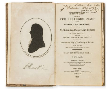
Ireland.- Hamilton (Rev. William) Letters Concerning the Northern Coast of the County of Antrim ..., engraved silhouette portrait frontispiece, 6 plates (lightly browned), and a folding map (large tear), contemporary ink inscriptions to blank prelim and title, contemporary calf, slight bumping to corners and extremities, Belfast, 1822 § Autobiography of an Irish Traveller, 3 vol. in 1, ink inscription, occasional foxing, contemporary half morocco, rubbed, 1837 § Letters from the Irish Highlands, ink inscription to title, bookplate of Toft Hall, contemporary half calf, rebacked, rubbed, 1825; and another, similar, 8vo (4)
Lot 53
Ireland.- Head (Sir Francis) A Fortnight in Ireland, first edition, folding map frontispiece (tear, repaired and linen-backed), contemporary half calf, gilt, a little rubbed, 1852 § [Thackeray (William Makepeace)] "Mr M. A. Titmarsh", The Irish Sketch-Book, 2 vol., second edition, frontispieces, illustrations, ink inscription to title, bookplates, occasional light spotting, later calf by Riviere & Son, gilt, cracked upper joints (vol. 1 only), 1845; and another later, single volume edition of the same, 8vo (4)
![Ireland.- [Melville (Edward)] Sketches of Society in France and Ireland, in the Years 1805-6-7, 2 vol. in 1, ink inscription](https://cdn.globalauctionplatform.com/299a3b32-90e6-4697-916d-a88f00c37d76/86d63263-b83e-43b2-aa53-799a7397d19f/468x382.jpg)
Lot 54
Ireland.- [Melville (Edward)] Sketches of Society in France and Ireland, in the Years 1805-6-7, 2 vol. in 1, ink inscription to title, occasional ink corrections and annotations, small hole to errata (repaired), small marginal worm damage (several repairs), loss to 2 leaves affecting text (vol. 2, I5-6), contemporary half calf, rebacked with original spine laid down, rubbed, Dublin, 1811 § Lumsden & Son's Steam-Boat Companion; or Stranger's Guide to the Western Isles & Highlands of Scotland ... with an Excursion through the North of Ireland ..., third edition, 3 folding engraved maps, 4 plates, ink inscriptions, occasional very faint spotting, original cloth, rubbed, bumping to corners and spine extremities, Glasgow, 1831 § Goldsmith (Rev. J.) The British Empire in 1827, folding engraved map frontispiece and 6 maps (3 folding), 38 plates (2 folding), lacking front free endpaper, publisher's advertisements pasted inside boards, contemporary calf, rubbed, [1827]; and 4 others, similar, 8vo & 12mo (7)
Lot 55
Ireland.- Robertson (Rev. Joseph) The Traveller's Guide Through Ireland, folding engraved hand-coloured map, small tear and light off-setting, occasional spotting and marginal pencil markings, cracked joints, bookplate of Rev. Daniel Augustus Beaufort, contemporary half calf, rubbed, 12mo, Edinburgh, 1806.⁂ Beaufort was an Anglican Priest, a geographer and an amateur architect, who played a vital role in the foundation of Sunday Schools and helped found the Royal Irish Academy. He was rector of Navan, County Meath from 1765 to 1818.
![Ireland.- [Wilson (William)] The Post Chaise Companion or Travellers Directory through Ireland, fourth edition, engraved fron](https://cdn.globalauctionplatform.com/299a3b32-90e6-4697-916d-a88f00c37d76/9b269007-876a-4521-ad76-0d4392523ba6/468x382.jpg)
Lot 57
Ireland.- [Wilson (William)] The Post Chaise Companion or Travellers Directory through Ireland, fourth edition, engraved frontispiece, title, large folding map of Ireland, folding plan of the lakes of Killarney, and 3 plates (2 folding), offsetting, spotting, light browning, contemporary half calf, rebacked, preserving original gilt backstrip (with loss at ends), corners worn, rubbed, a scarce edition, 8vo, Dublin, J. Fleming, [c.1814].

Lot 58
London.- Wyld (James) Wyld's New Plan of London and its Vicinity, showing from Highgate down to Brixton, and Victoria Docks across to Wormwood Scrubs, lithographed map with hand-colouring, 800 x 1140 mm. (31 1/2 x 44 3/4 in), dissected and mounted on linen, minor surface dirt and light browning, folding into original cloth covered boards with printed label, worn, spine splitting, [Hyde, 119], 1872.

Lot 6
Australia.- Labillardiere (Jacques Julien Houton de) Atlas pour servir à la Relation du voyage à la Recherche de La Pérouse..., atlas only (without the 2 text vol.), engraved throughout with title, folding map and 43 plates, ink signature at head of title, damp-staining and occasional worming at foot, mostly marginal to plates but occasionally affecting caption, title and map more severely stained, contemporary vellum-backed marbled boards, rather worn and stained, folio, Paris, H.J.Jansen, An VIII [1800]; sold not subject to return

Lot 60
Somerset and Dorset.- Speed (John) Somerset-Shire described, inset bird's-eye view of Bath, upper left, coats of arms lower left, royal arms and ships off the north coast, engraved map, on laid paper, 385 x 510 mm. (15 1/4 x 20 in), laid onto antique paper support, map appears not to have text on verso, even browning, surface dirt, central vertical fold with repaired splitting, scattered small nicks and tears, Sudbury and Humble, c. 1610 and later § Dorset.- Blaeu (Johannes) Comitatus Dorcestria, sive Dorsettia, engraved map with hand-colouring, 380 x 495mm., laid onto linen, even browning with repaired tears, [Amsterdam], c. 1660; together with 13 other maps and plans relating to Somerset and Dorset, including several plans of Bridport with James Green's 'Plan of Bridport Harbour', 1828, and a Blome map of Somerset, and James Cary's 1805 map of Dorset, engravings, some with hand-colouring, largest 390 x 530 mm. (15 1/2 x 20 7/8 in), several presented in mounts, the others loose, unframed, occasional surface dirt and minor nicks, mainly 18th and 19th century, (15).

Lot 71
Biblical commentaries.- Tirinus (Jacobus) In S. Scripturam commentarius duobus tomis comprehensus, 2 vol., half-titles, title in red and black and with engraved vignette, folding engraved map of the Holy Land, 6 double-page letterpress tables, woodcut printer's device at end,short splits to folds of map, convent ink stamps to title, some spotting or staining, contemporary blind-stamped calf over wooden boards, remains of clasps, crudely rebacked, folio, Antwerp, Henrick Aertssens, 1645.


Lot 80
S.E. FABER 'Shanghai', 'Tienshanhu' and 'Sungkiang', three pen, ink and wash maps, c.1930's, 81cm x 50cm; together with tracings by the same hand from 'W.C.B. Maps' - 'Hangchow Bay', illustrating the bay and then further detailing different areas, 47 x 76cm; together with associated printed matter to include: Whangpoo Conservancy Board - 'The district around the approaches to Shanghai' 107 x 111cm; 'Automobile Club of China - map of the seven-province highway system' (x1) and 'Road map of Shanghai and district' after S.E. Foster (x3); and further associated items, all unframed


Lot 100A
WILLIAM HOLE AFTER CHRISTOPHER SAXTON 'Caernarvo Comitatus Pars Olim Ordovicum', double page engraving, hand coloured, 25.5 x 31cm; and four further items to include C & J Greenwood 'Map of the County of Oxford'; Richard Blome 'A Mapp of Warwickshire'; a map of Staffordshire; and David Loggan - New Inn Hall (5)


Lot 51
CHRISTOPHER BROWNE'S NOVUS TOTIUS ANGLIAE TABULA: A NEW MAPP OF THE KINGDOM OF ENGLAND DATED 1735 inscribed 'A New Mapp of the Kingdom of England, shewing Its Antient and Present Government being Divided as in the Saxon-Heptarchy also in the Diocesis, Judges-Circiutts and Countyes Describing all the Citys, Market Towns, Parishes and many of ye Villages, Nobile & Gentlemens Seats the Roads and Distances in Measured Miles according to Mr Ogilbys Survey with many other Additions and Corrections not Extant in any other Mapp. To His Hignnesse the Duke of Cumberland. This Map is most humbly Dedicated & Presented By his Highness most humble Servants Phil: Overton and Tho: Bowles. 1735.' 182cm x 178cm Note: Christopher Browne (fl.1688-1712) was apprenticed to Robert Walton and after his death in 1688 took over his stock. This map was first issued by Browne in 1700 and was to prove to be hugely popular being reproduced several times throughout the first half of the eighteenth century. Several examples are known with both his St Paul's address and that of the Royal Exchange. After 1712 the plates past to Philip Overton and Thomas Bowles as in this example, published in 1735.
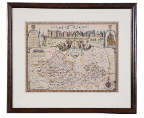
Lot 337
A group of three maps of Berkshire interest , comprising, Berkshire. Speed (John), Barkshire described , with decorative title cartouche, compass rose, costumed figure, and large view of Windsor Castle, hand coloured engraved map, Sudbury and Humble, [1611], mounted, framed and glazed 61 x 72cm overall, Berkshire. Blaeu (Johannes), Bercheria vernacule Barkshire, decorative title cartouche upper centre, coats-of-arms upper left and right, hand coloured engraved map,, Amsterdam, [c.1645 or later], mounted, framed and glazed 60 x 72cm overall, and Ogiby (John), The road from Oxford to Salisbury , double page, engraving, not coloured, mounted, framed and glazed, 58cm x 67cm overall (3)
-
109198 item(s)/page