We found 109198 price guide item(s) matching your search
There are 109198 lots that match your search criteria. Subscribe now to get instant access to the full price guide service.
Click here to subscribe- List
- Grid
-
109198 item(s)/page


![[HUNTING]. BIG GAME Stockley, Lieut.-Colonel C.H. Stalking in the Himalayas and Northern India, first edition, Jenkins, Londo](https://cdn.globalauctionplatform.com/0d407f89-b32b-4ed3-9481-a5ce009e828f/839fd2e8-f80f-4ee4-8886-ca7f8dafe9a5/468x382.jpg)
Lot 609
[HUNTING]. BIG GAME Stockley, Lieut.-Colonel C.H. Stalking in the Himalayas and Northern India, first edition, Jenkins, London, 1936, original green cloth, plate illustrations from photographs, octavo; Hagedorn, Hermann. Roosevelt in the Bad Lands, first British edition, Melrose, London, no date [1921], original blue cloth, top edges gilt, plate illustrations from photographs, folding map, quarto; and a further eleven assorted works, (13).
![[FISHING] Everard, Mark. Redfin Diaries. A Life in the Year of a Roach Enthusiast, limited edition 105/200 SIGNED BY AUTHOR,](https://cdn.globalauctionplatform.com/0d407f89-b32b-4ed3-9481-a5ce009e828f/35ffe130-56a3-4062-b542-b851411b6e7b/468x382.jpg)
Lot 627
[FISHING] Everard, Mark. Redfin Diaries. A Life in the Year of a Roach Enthusiast, limited edition 105/200 SIGNED BY AUTHOR, Coch-u-Bonddu Books, Machynlleth, 2013, boards, dustjacket, octavo; Newland, Rev. Henry. The Erne, its Legends and its Fly-Fishing, Chapman & Hall, London, 1851, blind-stamped brown cloth (lacking upper cover and spine strip), octavo (sold with all faults, not subject to return); The Angler's Guide to the Irish Free State, third edition, The Stationery Office, Dublin, 1937, original green cloth, folding map, octavo; and a further twenty-four assorted works, (27).
![[FISHING] Aflalo, F.G. Sea & Coast Fishing, Grant Richards, London, 1901, original pictorial blue cloth, illustrations, octav](https://cdn.globalauctionplatform.com/0d407f89-b32b-4ed3-9481-a5ce009e828f/c9eacf60-c5b4-4434-e063-694882d25c58/468x382.jpg)
Lot 623
[FISHING] Aflalo, F.G. Sea & Coast Fishing, Grant Richards, London, 1901, original pictorial blue cloth, illustrations, octavo; Armistead, Wilson. Trout Waters, Management and Angling, Black, London, 1920, original pictorial green cloth, folding map, period advertisements, octavo; Tod, E.M. Wet-Fly Fishing Treated Methodically, second edition, Sampson Low, Marston & Company, London, 1907, original decorative green cloth, portrait frontispiece, octavo; and a further nine assorted works, (12).

Lot 284
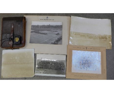
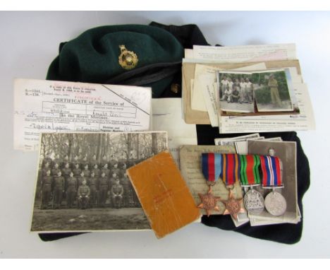
A Second World War 44 Royal Marine Commando medal, uniform and document group, that of CHX106486 Marine R C Haverson, and comprising campaign medals (post-War issue), blue uniform, 1943 dated green beret, a silk escape map signed by the unit, and an extensive archive of documents and photographs including Commando Service Certificate and Certificate of Service


Lot 152
Cyprus, P 38s, Linzmayer B202as, Republic of Cyprus, 500 Mils, 1 December 1961, SPECIMEN. Coat of arms of Cyprus at right, map of Cyprus at lower right. Horizontal red overprint SPECIMEN OF NO VALUE in upper left margin on front and back. Diagonal purple handstamp CANCELLED on front. Mountain road lined with trees on back. Perforated CANCELLED., # A/1 000000, ICG 68, Gem UNC, two small pinholes

Lot 153
Cyprus, P 39s, Linzmayer B203as, Republic of Cyprus, 1 Pound, 1 December 1961, SPECIMEN. Coat of arms of Cyprus at right, map of Cyprus at lower right. Horizontal red overprint SPECIMEN OF NO VALUE in upper left margin on front and back. Diagonal purple handstamp CANCELLED on front. Viaduct and pillars on back. Perforated CANCELLED., # A/1 000000, ICG 66, Choice UNC, two small pinholes


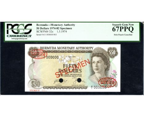
Lot 95
Bermuda, P 32s, Linzmayer B205as3, Bermuda Monetary Authority, 50 Dollars, 1 May 1974, SPECIMEN. Portrait of Queen Elizabeth II at right on front. Signatures Dudley St. George Butterfield - Roy J. Clifford. Gibbs Hill lighthouse in Southampton Parish at left center, map of Bermuda at upper right, coat of arms of Bermuda at center right on back. Diagonal red overprint SPECIMEN as well as red ovals DE LA RUE NO VALUE on front and back. Red SPECIMEN NO 061 in lower left margin on front. Punched cancelled., # A/1 000000, PCGS 67 PPQ, Superb Gem New.

Lot 48
A John Speed coloured county map 'Buckingham Both Shyre, and Shire: towne defscrib'... and are to be fold by Tho.Bafsett in Fleet Ftreet, and Ric: Chifwell in St Pauls Church yard, with inset birdseye maps of Redding & Buckhamm and the arms of noble families 15'' x 20'' in a glazed gilt frame


Lot 467
Cilicia, Mallos AR Stater. Circa 440-390 BC. Winged male deity (Kronos?) advancing right, holding solar disk with both hands / Swan standing left, MAP above, fish downwards to left; all within pelleted square border within incuse square. Casabonne Group 4; SNG France -; SNG von Aulock -; cf. BMC 12, pl. xvi, 8 (dotted incuse square, but grain kernel in place of fish); cf. Traité II 1399 = SNG Paris 378 (no square incuse or border, and ankh behind swan); SNG Levante -; Gemini IV, 209; otherwise apparently unpublished. 11.18g, 22mm, 1h. Near Mint State. Extremely Rare, perhaps the second known example. Beautiful early style, and in exceptional condition for this early series; very possibly the finest known example. Mallos (archaically known as Marlotas) issued a rich coinage between the early fifth century and 333 BC, when it came under Macedonian hegemony, featuring Greek deities including Herakles, Aphrodite, Athena, Hermes, Dionysos and Demeter, as well as securely identifiable oriental deities such as Baal and Ahuramazda. The solar deity present on the obverse of this coin is sometimes identified as Kronos (a Semitic god more properly known as 'El', and distinct from the Greek Titan and father of the Olympian gods, but with whom he was syncretised by Greeks). This seems eminently logical, since the spiral - which Robert Graves called a 'spiral of immortality' (The White Goddess, 1948), a symbol of power most likely appropriated from the Red Crown of Lower Egypt - and solar disc attributes do not belong to any Olympian deity, but to one of near-Eastern origin. It has moreover been suggested that Mallos was originally of Phoenician foundation (see IACP, 1009) on the basis of its original ethnik, a suggestion supported by the presence of other Semitic deities portrayed on the city's coinage, as well as the use of Aramaic legends. Curiously, the attribute of the solar disc is one with few parallels in the archaeological record. In a similar pose, a male solar deity is carrying a sun disc on a 6th century orientalising archaic Greek scarab from Cyprus, and an alabastron from the Isis tomb at Vulci, Etruria (suggested locations for its manufacture are Cyprus and Phoenicia) depicts a female carrying a winged sun disc. Possibly related also are Phoenician terracotta figurines from Punic sites holding a disc in front of them. In all cases a Semitic origin is apparent, further strengthening the likelihood that the deity of this coin should be the Semitic solar god Kronos.

Lot 468
Cilicia, Mallos AR Obol. Circa 440-390 BC. Bearded janiform head / Head (of Bellerophon?) left, wearing cap; MAP before; all in dotted square within incuse square. Cf. CNG 90, 23 May 2012, lot 642 (sold for $1,100). 0.59g, 8mm, 6h. Good Very Fine. Slightly granular surfaces, lightly toned, of good style. Extremely Rare.
![[CHILDRENS] Milne, A.A. Winnie-the-Pooh, first edition, Methuen, London, 1926, original pictorial dark green cloth gilt, top](https://cdn.globalauctionplatform.com/06e4927d-6732-4ff0-bdff-a5ce009f5463/ca35a332-6b6b-42a7-9e62-c9e4481b53fb/468x382.jpg)

Lot 245
ASSORTED COLLECTABLES comprising a book, Flowers from the Holy Land, containing pressed flowers, with olive wood covers; a black velvet evening clutch bag with bullion thread decoration; a French beaded clutch bag, circa 1930s; a printed silk map of Burma, circa 1940s; a pair of opera glasses, cased; an ebony hand mirror; and a small quantity of other items.
![[TOPOGRAPHY]. GREAT BRITAIN The Tourist's Manual; or, An Account of the Principal Pleasure Tours in Scotland, eighth edition,](https://cdn.globalauctionplatform.com/06e4927d-6732-4ff0-bdff-a5ce009f5463/1b551b63-7863-4e48-f8f8-5399949b8765/468x382.jpg)
Lot 207
[TOPOGRAPHY]. GREAT BRITAIN The Tourist's Manual; or, An Account of the Principal Pleasure Tours in Scotland, eighth edition, for Thomson et al., Edinburgh, 1832, half calf (rebacked), ten illustrations (of twelve; lacking two maps; another folding map incomplete), octavo; and A Description of England and Wales..., Volume II, for Newbery & Carnan, London, 1769, full speckled calf (rebacked), comprising Cheshire, Cornwall, The Scilly Isles and part of Cumberland, nine engraved plate illustrations, further text illustrations, octavo, (2).
Lot 259
ASSORTED COLLECTABLES comprising a beret with 8th King George's Own Light Cavalry cloth badge, dated 1943; a folding map of part of India, dated 1941; a pair of Pakistani slippers with bullion thread decoration; a pair of Indian child's slippers; an oak cigarette box by Swaine & Adeney, the lid with an inset embossed silver plaque depicting a horse-racing scene (lid broken and glued); and a green leather photograph frame by Asprey (visible aperture approximately 28cm x 23cm).


Lot 1
Andersson (Charles John). Lake Ngami; or, Explorations and Discoveries, during Four Years' Wanderings in the Wilds of South Western Africa, 2nd ed., 1856, folding map, 15 lithographed plates, frontispiece detaching, some spotting, recent tan half morocco, 8vo, together with Emin Pasha and the Rebellion at the Equator. A Story of Nine Months' Experiences in the last of the Soudan Provinces, by A.J. Mounteney-Jephson, 1st ed., 1890, folding map, facsimile letter, wood-engraved illustrations, a few spots, recent red half morocco, 8vo, with other African travel including H.M. Stanley's In Darkest Africa, 2 vols., 1890, Through the Dark Continent, 2 vols., 1899, and The Autobiography of Sir Henry Morton Stanley, 1909 (all rebound) (10)
Lot 105
Kingdon Ward (F.). A Plant Hunter in Tibet, 1st edition, Jonathan Cape, 1934, sixteen black and white plates from photographs (correct as list), folding map, author's autograph pasted onto title page, original publisher's cloth in d.j. (jacket slightly frayed at extremities), 8vo, autographed letter signed from the author to Mrs Cadbury, on Hatton Gore, Middlesex headed paper, dated 20 December 1934 loosely inserted (1)

Lot 13
Campbell (John). Travels in South Africa, Undertaken at the Request of the London Missionary Society; Being a Narrative of a Second Journey in the Interior that Country, 2 vols. in one, 1st ed., 1822, half titles, hand-coloured folding map (one fold with neat repair), 12 hand-coloured aquatint plates, some offsetting and a few spots, contemporary previous owner inscription to title, modern calf-backed boards, spine with red and green labels and blindstamped decoration, 8vo Abbey Travel 328. (1)
Lot 136
Bradley (Tom). The Yorkshire Anglers' Guide to the Whole of the Fishing on the Yorkshire Rivers, Olicana Books, 1979, advertisements front and rear, folding map tipped onto separate green wrapper, original green full morocco gilt, slipcase, 8vo Limited edition, 1/200. Facsimile reprint of the 1894 edition. (1)
Lot 14
Campbell (John). Travels in South Africa, Undertaken at the Request of the Londonm Missionary Society; Being a Narrative of a Second Journey in the Interior of that Country, 2 vols., 1st ed., 1822, folding map, 10 hand-coloured plates only (of 12, lacking two in volume I), two leaves detached in volume I, some offsetting and light spotting, contemporary half calf, a little rubbed, 8vo, together with 'Twixt Sirdar & Menelik. An Account of a Year's Expedition from Zeila to Cairo through Unknown Abyssinia, by the Late Captain M.S. Wellby, 1st ed., 1901, half-tone illustrations, later black half morocco, edges a little rubbed, 8vo, plus Sunshine and Storm in Rhodesia, by Frederick Courtney Selous, 1st ed., 1896, folding map, illustrations, toning front and rear, later morocco-backed boards, 8vo, with other African travel including James Backhouse's A Narrative of a Visit to the Mauritius and South Africa, 1844 (lacking one map) and Edward North Buxton's Short Stalks: or Hunting Camps North, South, East, and West, 2nd ed., 1893, & Short Stalks, second series, 1898 (12)

Lot 152
Macky (John). The Diary of an Irish Water Bailiff 1791-1809, ed. E.J. Malone, Ken Smith Publishing, 2008, folding map, illustrations, all edges gilt, original burgundy goatskin, slipcase, 8vo Limited edition, one of 10 (copy 'i') signed copies of a total edition of 60, with an original salmon fly 'The Judge' tied by Peter Kealey and displayed in an oval sunken mount at front. (1)

Lot 153
Magee (Leslie). Fly Fishing. The North Country Tradition, 2 vols. (text/flies), Smith Settle, Otley, 1994, folding map and colour illustrations to text volume, second volume with 30 specimen flies displayed within five sunken card mounts, original green full and quarter bound goatskin, slipcase, small 4to Edition de Luxe, copy 'A' (publisher's copy), of 10 hors commerce copies (lettered A-J), from a total edition of 60, signed by the author. (2)
Lot 17
Chamich (Father Michael). History of Armenia from B.C. 2247 to the Year of Christ 1780, or 1229 of the Armenian Era, Translated fom the Original Armenian, by Johannes Avdall, to which is appended a Continuation of the History by the Translator from the Year 1780 to the Present Date, 2 volumes, 1st English edition, Calcutta: printed at Bishop's College Press by H. Townsend, 1827, list of subscribers, folding engraved map and two folding engraved plates, all with closed tears and repairs to versos with slight loss, paper browned, small wormholes throughout (as often), early 20th century black half morocco, a little rubbed and scuffed, 8vo The first history of Armenia in English to draw extensively from Armenian sources. (2)

Lot 18
Cluverius (Philippus). Philippi Cluveri Introductionis in Universam Geographiam tam venterem quam novam..., volume 4 (only), published Amsterdam, 1676, title page printed in red and black, thirty-three (only) double page engraved maps and one plate, index bound at rear, book plate of Hugh Cecil Earl of Lonsdale, contemporary sheep, upper board detached, rubbed and worn, 8vo, together with, Salmon (Thomas), A New Geographical and Historical Grammar: wherein the Geographical part is Truly Modern and the Present State of the Several Kingdoms of the World..., to render the Study of Geography both Entertaining and Instructive..., 9th edition, published Dublin, 1760, additional half title, title page printed in red and black, eighteen (only of 23) double page and folding engraved maps, but retaining the hemispheral map of the world and North America, some maps split and torn, lacking preliminary leaves, contemporary calf, upper board detached, rubbed and worn, 8vo, with, Mogg (Edward), Paterson's Roads; Being an Entirely Original and Accurate Description of all the Direct and Principal Cross Roads in England and Wales..., 18th edition, circa 1830, folding engraved map of England & Wales, with a further eight uncolored folding regional maps, appendix bound at rear, book plate of Charles Green to front endpaper, book plate of George Warren Swire to rear endpaper, contemporary half morocco gilt, upper board near detached, rubbed and worn 8vo Sold as a collection of maps, not subject to return. (3)

Lot 185
Americas. Homann (Johann Baptist), Totius Americae Septentrionalis et Meridionalis Novissima Repraesentatio quam ex singulis recentium Geographorum Tabulis collectaluci publicae accomodavit..., published Nuremberg, circa 1730, engraved map with contemporary hand colouring, slight creasing, two repaired marginal closed tears affecting image, central fold slightly browned, 495 x 580 mm (1)
Lot 19
Cotton (Lieutenant-General Sir Sydney). Nine Years on the North-West Frontier of India, from 1854 to 1863, Richard Bentley, 1868, black and white frontispiece, some scattered spotting, ownership inscription excised from front free endpaper, all edges gilt, contents slightly shaken, original publisher's decorative cloth, a little rubbed and scuffed, 8vo, together with Lawrence (T. E.), Seven Pillars of Wisdom, a triumph, Jonathan Cape, 1935, black and white portrait frontispiece, black and white plates and maps, bookplate to front pastedown, original publisher's cloth, few minor marks, slightly scuffed, 4to, plus Ferrier (J. P.), Caravan Journeys and Wanderings in Persia, Afghanistan, Turkistan, and Beloochistan, John Murray, 1856, two (of 3) black and white plates, folding map (laid onto linen), some dust-soiling and finger marks, ex library with usual stamps and labels, later half morocco with spine label, 8vo, plus other Middle Eastern, and Indian travel, mainly 19th century (40)
Lot 192
*Cardiganshire. Speed (John), Cardigan Shyre Described with the due forme of the Shiretown as it was surveyed..., published Henry Overton, circa 1710, hand coloured engraved map, inset town plan of Cardigan, large strapwork cartouche, mileage scale and compass rose, 385 x 505 mm, mounted, framed and glazed (1)
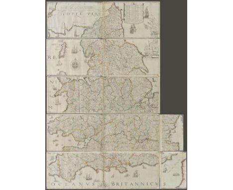
![*Cornwall. Speed (John), Cornwall, published Thomas Bassett & Richard Chiswell, [1676], hand coloured engraved map, inset vie](https://cdn.globalauctionplatform.com/ea36b011-2df7-4bfe-b658-a5d301078b15/a8a53227-1abc-4c85-e258-1a9e36e792d2/468x382.jpg)

Lot 195
Devon. Speed (John), Devonshire with Excester Described and the Armes of such Nobles as have borne the titles of them, published Roger Rea, circa 1662, uncoloured engraved map, inset town plan of Exeter, central fold partially split, small blind stamp to margin, one small repaired marginal closed tear, slight staining to margin, 510 x 380 mm, English text on verso (1)

Lot 196
Dorset. Speed (John), Dorsetshyre with the Shyre-towne Dorchester described as also the Armes of such noble families as have bene honored with the Titles thereof since the Normans Conquest to this present..., published Roger Rea, circa 1662, uncoloured engraved map, inset town plan of Dorchester, short split to central fold, repaired on verso, occasional marginal closed tears, small library blind stamp to margin, 385 x 510 mm, English text on verso (1)
Lot 197
England & Wales. Speed (John), The Kingdome of England, published Roger Rea, circa 1662, uncoloured engraved map with eight costumed figures to vertical margins, some creasing, some adhesion to central fold which is also split with slight loss, small library blind stamp to margins, torn in each corner with slight loss, closed tears with some affecting image, crudely repaired on verso, 385 x 510 mm, English text on verso, together with, Kent with her Cities and Earles Described and observed, published Roger Rea, circa 1662, uncoloured engraved map, inset town plans of Canterbury and Rochester, heavily creased, several closed tears and fraying with some loss to image, slight staining, library blind stamp to margin, 380 x 510 mm, English text to verso (2)
Lot 198
England & Wales. Lea (Philip), Untitled map taken from Christopher Saxton's large scale map of England and Wales first published in 1583, this state published Philip Lea, Globemaker at ye Atlas and Hercules in Cheapside nere the corner of Fryday Street in London, [1687 - 1700], engraved map with contemporary outline colouring on five sheets, with two additional loose sheets, bound in contemporary vellum with manuscript title 'Mappe of England' on outside of vellum and rolled presumably to facilitate ease of carriage when travelling, half compass rose, table of longitude and latitude of principal towns, some fraying to map strip margins, appears to be lacking two smaller portions (East coast of Norfolk & Suffolk and South West Cornwall), each sheet approximately 285 x 855 mm, two loose sheets approximately 280 x 200 mm R.W.SHirley. Early Printed Maps of the British Isles 1477 - 1650, no.137, state 5. Christopher Saxton published his twenty sheet wall map in 1583. It was re-issued by Cade & Morgan in 1678. Philip Lea aquired the copper plates in about 1685 and re-published the map on a smaller scale designed to be used as a travelling map. He reduced the map to ten full sheets and four half sheets and removed a great deal of the sea, thus making the map relevant to land based travellers. The map was pasted into five horizontal strips. The top three sheets made up of two sheets and the last two sheets made of two sheets with a half sheet pasted at each end. It appears that two of these half sheets are lacking from this example. Philip Lea re-engraved the plates at least five times during his perod of ownership. This example is his 5th and final state and therefore state 7 of a total of nine states. Lea moved from Poultry to Cheapside in 1687 and remained there until 1700. Following Lea's death, Anne his widow, re-engraved and re-issued the map with Richard Glynne in 1720 and Thomas & John Bowles & Son repeated this in 1758. Scarce. (1)
Lot 199
*England & Wales. Blaeu (Johannes), Anglia Regnum, circa 1660, hand coloured engraved map, slight spotting to margins, 390 x 505 mm, framed and double glazed, Latin text on verso, together with, Staffordiensis Comitatus vulgo Stafford Shire, circa 1648, engraved map with contemporary outline colouring, slight staining and creasing, 415 x 505 mm, framed and double glazed, Latin text on verso, with, Van den Keere (Pieter), Salopia, Herefordshire, Worcestershir [and] Mounmouthshire, circa 1627, together four engraved maps, including two with hand colouring, some staining to Hereford and Monmouth, each approximately 85 x 125 mm, mounted, framed and double glazed, three maps with English text on verso (Hereford, Worcestershire & Monmouthshire) and Shropshire with Latin text on verso (6)
Lot 20
Creighton (Henry). The Ruins of Gour Described and Represented in Eighteen Views; with a topographical map, 1st ed., 1817, half-title, folding hand-coloured engraved map of Gour in 1801, eighteen fine hand-coloured aquatint plates after T. Medland, manuscript note loosely inserted "Presented to the India Office Library by the Rev. Charles Arthur Molony, M.A. late vicar of Saint Lawrence, Thanet, a Grandson of Mr. Henry Creighton, the author of this book...", contemporary polished calf gilt, with gilt armorial of the East India College to centre of each board, spine slightly worn & joints cracked, slim 4to East India College presentation label to upper pastedown, awarded to W.L. Wilkinson as first of his class in drawing, dated 3 December 1822. Abbey Travel 438. Rare. (1)
Lot 200
England & Wales. Faden (William), A Map of England, Wales & Scotland describing all the Direct and Principal Cross Roads in Great Britain with the Distances measured between the Market Towns and from London; to acompany Paterson's Book of the Roads, 1801, engraved map with contemporary hand colouring, inset map of Scotland, 740 x 610 mm, together with, Pinkerton (John, publisher),England Northern Part [and] England Southern Part, 1811, two engraved maps by J.Neele, with contemporary hand colouring, each sheet approximately 520 x 720 mm (3)
-
109198 item(s)/page