

Catlin, George Letters and Notes on the Manners, Customs, and Condition of the North American Indians. Published by the Author at the Egyptian Hall, Piccadilly, 1841. 8vo, half calf over marbled boards, spines with contrasting morocco lettering-pieces, marbled endpapers and edges; I: errata slip, b/w plates after Catlin's sketches numbered 3-114 [no 2 + 23, but with 100 1/2, 113+114 present], with add. unnumbered frontis., map, and three plates between pp.148-54; II: numbered plates 115-312 [lacking 137, 142, 149, 159, 246, 247, 271, 272], unnumbered map and chart. First ed., first issue of I (with 'Frederick' on p.104), second ed. (from title-page) of II. A hugely important first-hand account of the lives of Native American tribes with a wealth of anthropological and cultural information as well as detailed and exciting pictures.
We found 109198 price guide item(s) matching your search
There are 109198 lots that match your search criteria. Subscribe now to get instant access to the full price guide service.
Click here to subscribe- List
- Grid
-
109198 item(s)/page
![The Holy Bible [KJV] KJV bound before Sternhold and Hopkins. KJV: Imprinted at London by Bonham Norton and John Bill, 1628 [L](https://cdn.globalauctionplatform.com/f296de29-53dc-4405-a508-aaef00d56230/bc267aeb-3ae9-4706-a01e-ab0d00ac2a9e/468x382.jpg)
The Holy Bible [KJV] KJV bound before Sternhold and Hopkins. KJV: Imprinted at London by Bonham Norton and John Bill, 1628 [Lacking OT title, dated from NT]; Sternhold: Printed for the Company of Stationers, 1629. 8vo, full contemporary paneled calf; unpaginated, signed: A8 [lacking A1 and 8], A8-3R8 [lacking B7, N8, 2S3+6, 3D2]; Sternhold: A8-F8 [lacking D8 and G1-end (?G8)]. Herbert 411 [but no Geanealogies and map]


Various RAF related and other ephemera items, etc. a quantity of maps, limited edition helicopter print, Salisbury Plain, Larkhill and West Down plan map, 114cm W, various other pictures, Her Majesty's Command framed certificate, helicopter photographic prints and other pictures, etc. relating to helicopter flights, various other photographs of helicopters, aeroplanes, etc. (a quantity)


FACTORY/MANCHESTER MEMORABILIA. Collection of Manchester/Factory memorabilia to include: 1978 'Spherical Objects' cover only, a ticket for a New Order at The Ritz, a page bearing signatures to one side by Shaun Ryder and to verso by Bez, letters on Hacienda and 'Factory Too' stationary relating to a proposed exhibition of Manchester memorabilia, a roll of the Peter Saville designed Manchester gift wrap (sealed), a New Order poster, a Manchester music map, a FAC 305 cassette.


Rizzi Zannoni, Topografica Dell' Agro Napoletano, monochrome map, canvas backed, 1793; Botte, Carte Postale ed Itineraria Dell' Italia, hand coloured map, canvas backed, 1838; Sickler, Plan Topographique de la Campagne de Rome, monochrome map, canvas backed, 2nd edition, 1816; Pianta Topografica della Citta di Roma dell' anno 1818, monochrome map, canvas backed. (Qty: 4)

Arrowsmith, John, The London Atlas of Universal Geography, exhibiting the Physical & Political divisions of the various Countries of the World, constructed from original materials, sold by James Gardner Jnr, 33 Brewer St, Golden Sq., containing 50 hand coloured maps, South Eastern Australia dated 1841, Western Australia dated 1839, Upper Canada dated 1838, Lower Canada dated 1838, South America dated 1839, La Plate, Uruguay & Chile dated 1839, all other maps dated 1840, plus pasted in a small map Part of the Canton River showing the position of H. M. Ships, May 26th 1841.


Gilpin, Two Vols in One - OBSERVATIONS...CAMBRIDGE, NORFOLK, SUFFOLK AND ESSEX, 1809, 19 plates, 208pp bound with Gilpin Two Essays 1804, 43pp, together with 3 SUFFOLK GREEN BOOKS, NRS 9, 10 and 11, with rebounds excerpts from Pigot (inc. Pigot 1839 with hand coloured folding map) and a quantity of Suffolk History and Biography
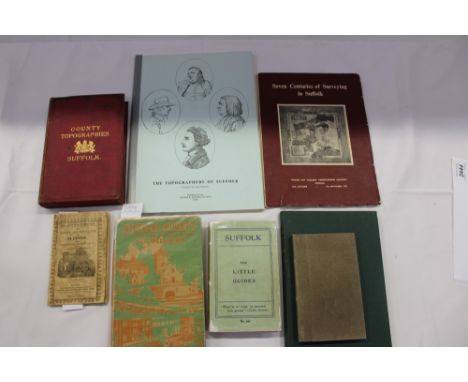
Suffolk History and Topography - to include Pinnock’s County Histories - THE HISTORY AND TOPOGRAPHY OF SUFFOLK,, pub. London, with folding map, together with O. R. Wellbanks - SUFFOLK MY COUNTY, 1934 (with dust jacket); William Dutt Suffolk, The Little Guides, 5th edition; TOPOGRAPHICAL AND HISTORICAL DESCRIPTION OF THE COUNTY OF SUFFOLK, with folding map, also Professor Skeat - THE PLACE NAMES OF SUFFOLK, others.
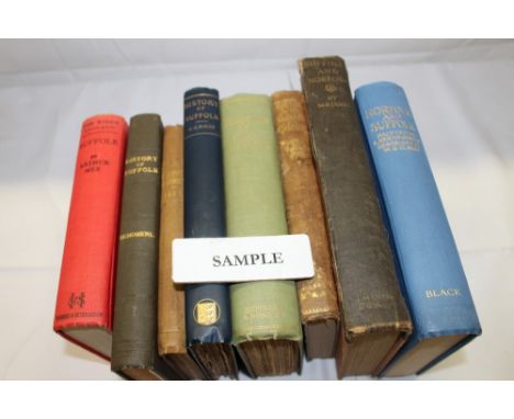
Suffolk Guides and History - including J. Glyde - SUFFOLK IN THE 19TH CENTURY, original tooled cloth binding, Rev. Cannon F. J Meyrick - ROUND ABOUT NORFOLK & SUFFOLK,inscribed by the author, Dr. J. E. Taylor - TOURIST GUIDE TO SUFFOLK, with folding map 1887, Leonard P. Thompson - OLD INNS OF SUFFOLK, F Schoberl - HISTORY OF SUFFOLK, BEING PART OF THE BEAUTIES OF ENGLAND AND WALES, London 1812, Henry Alfred - THE SUFFOLK RECORDS, M. R. James - SUFFOLK AND NORFOLK, Vincent B. Redstone - MEMORIALS OF OLD SUFFOLK, 1st Edition pub. London 1908, J. J. Raven - HISTORY OF SUFFOLK, London 1895, NORFOLK AND SUFFOLK PAINTED BY A. HEATON COOPER (a good copy), Herbert W. Tompkins - COMPANION INTO SUFFOLK, others

Thomas Gardiner - DUNWICH, BLYTHBURGH AND SOUTHWOLD, 1754, the Henham Hall copy, the Rev. W. B. Philpot’;s copy, given him by his father 9. 1. 1871, was passed on to John Edmond Cornwallis Rous (4. 8. 1871), 2nd Earl of Stadbroke, the copy contains the letter of gift, dated and signed by Philpot, also loose is ‘A COPY OF CARDNER’S M.S.S - THE ONLY COPY IN EXISTENCE. CAPTAIN MAY HAD THE ORIGINAL - IT WAS ACCIDENTALLY BURNT AT IPSWICH’ the binding is full but worn calf, no lettering on spine, the large folding map is laid in, random annotations almost certainly by one or more members of the Rous family’s, post August 1871
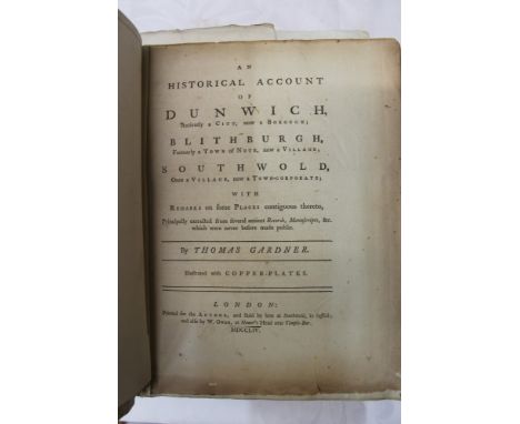
Thomas Gardner - AN HISTORICAL ACCOUNT OF DUNWICH, ANCIENTLY A CITY, London, printed for the author, and sold by him at Southwold, Suffolk and also by W. Owen, at Homer's Head near Temple Bar, 1754, 4to, title, pp (XVIII), 260, (VIII) pages 177-184 misprinted 161-168. Contemporary calf rebacked and repaired, large folding plan laid down on linen, the two plates called for in explanation of plates (and Upcott), two additional plates, one, the fine folding Southwest prospect of Southwold -not found in all copies, illustrations in text. This copy is unique, many blank leaves and bound in and many additional engravings are mounted: E.G. a copy of the large folding map is cut up, tinted with what appears to be varnish and mounted in appropriate portions of the text, all the illustrations in Ware’s Southwold (1839) including the folding plates are present, there are many manuscript pages, particularly for events between 1690-1705, we see the large folding engraving of ‘A view of the free British fishery: Shetland from Sumburgh Head Cliff’, there is a fine advertisement for the funeral of the Duke of Wellington, Nov. 18th 1852, ‘the Mayor expresses a hope that the inhabitants of the Borough (Southwold) will close their shops, suspend business....;’, the input of additional materials appears to have come at different times from the Rous and later the Blois family members


-
109198 item(s)/page