

North America . This finely engraved chart extends to include Cuba, Jamaica, St. Domingo, Greenland, Iceland, and all of Central America. A large area comprised of the Pacific Northwest and southern British Columbia is labeled ""Western Territory"" and reflect British interests in the area. Alaska is Russian Territory and Mexico occupies California, the Southwest and Texas. The states and provinces are not delineated in this early Hall issue. East of the Rockies the huge area is largely unnamed except for Dakoutas, but the river systems are very well delineated. The map is filled with place names including Indian villages. The title is in a simple rectangular block. Engraved by Sidney Hall. Original outline color with marginal soiling and minor creasing in top blank margin. 10.3"" W x 14.6"" H . Hall, Sidney . 1834
We found 109182 price guide item(s) matching your search
There are 109182 lots that match your search criteria. Subscribe now to get instant access to the full price guide service.
Click here to subscribe- List
- Grid
-
109182 item(s)/page
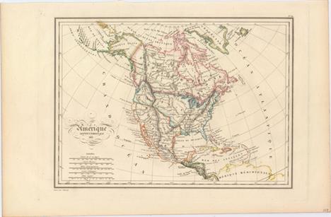
Amerique Septentrionale . An attractive map that shows all of North America, the Caribbean, and the northern portion of South America. This map was made just before Texas declared its independence in 1836, and shows Texas as a province within Mexico. The border between the United States and Canada extends into present-day British Columbia, reflecting U.S. interests in the area. Topography is depicted by hachure, and many native tribes are noted. The title is embellished with flourishes and five distance scales. Engraved by Thierry. Clean and bright with one errant spot of color at top left. 11.9"" W x 8.6"" H . Malte-Brun, Conrad . 1835

North America . Attractive copper engraved map showing an independent Republic of Texas. Mexico is in control of the Southwest and the border between the United States and Canada extends well into present-day British Columbia, reflecting U.S. interests in the area. West of the Mississippi there is little detail except for the river system, forts, and a few place names. Engraved by G.W. Boynton. Original color with some light scattered foxing. 11.5"" W x 14.2"" H . Bradford, Thomas Gamaliel . 1838

Carte de l`Amerique Septentrionale et des Antilles . Uncommon edition of this map of the continent with the Independent Republic of Texas and early western territorial borders in the United States. The District Oregon ou Colombie extends into present-day British Columbia and is bounded by the Rocky Mountains. Missouri Territory takes in the entire region between Oregon and the Mississippi except for the young states of Missouri, Arkansas and Louisiana. The map is filled with the locations of many Indian Districts and Tribes. The Aleutian Islands are shown in an inset on the same scale as the main map. A table at right lists 26 states and the territories of the United States, and another table lists 20 states for Mexico. There are light damp stains in the blank margin, entering the image in the top and bottom corners at right. A short fold separation confined to the right blank margin has been closed on verso with cello tape. 11.3"" W x 17"" H . Delamarche, Charles Francois . 1844

North America . Detailed and finely engraved map that portrays an Independent Texas and has Mexico controlling Nueva California. The boundary between Canada and the United States is unengraved, so the ownership of Oregon Territory (here labeled Columbia) is undetermined. Filled with well-developed topography, the map names numerous forts, trading posts, Indian tribes and locates L. Youla roughly near the Great Salt Lake with the American Fur Depot on its eastern shore. The R. Buenaventura extends to the Pacific from two branches, one originating from a large swamp in the Great Basin. The course of the Snake River is fairly accurate, but the Colorado River originates too far north and rushes to the Sea of Cortez in a straight line. Locates the three buttes in present-day Idaho -- important landmarks on the Oregon Trail and for earlier fur trappers. Lake Michigan retains its erroneous elongated shape. Distance scales outside of border give English Miles and Spanish Leagues. Engraved by J. & C. Walker and published by Charles Knight. Light toning with a few faint spots in the image. A couple of short edge tears are confined to the left blank margin. 12"" W x 15"" H . SDUK Society for the Diffusion of Useful Knowledge, 1845
![[Lot of 3] Map Illustrating the System of Parcs, the Domestic Relations of the Great Plains... [and] Map of North America De](http://lot-images.atgmedia.com/SR/36385/2914150/97-201495115231_468x382.jpg)
[Lot of 3] Map Illustrating the System of Parcs, the Domestic Relations of the Great Plains... [and] Map of North America Delineating the Mountain System and Its Details... [and] Thermal Map of North America, Delineating the Isothermal Zodiac... This lot includes three maps from William Gilpins Mission of the North American People, Geographical, Social and Political. Gilpin was the first governor of the territory of Colorado and a proponent of the concept of Manifest Destiny, the transcontinental railway, and a westward expansion of the United States. He had radical ideas on how and why America should be populated, and to support his theories he did a series of maps including these three. Interestingly, they were some of the first to show economic potential for the West and to think in terms of regional resources and climates. A. Map Illustrating the System of Parcs, the Domestic Relations of the Great Plains, the North American Andes, and the Pacific Maratime Front, (22.9 x 21.3""). This is a fascinating and colorful map of the western United States. The map is divided into regions with a System of Parcs following the Continental Divide. Several railroads bisect the West including the Texas Pacific, Atlantic and Pacific, Kansas Pacific, Union Pacific and North Pacific. Several railroads are not named including two that extend south though Mexico. Also includes details of the Indian Reservations, forts and watershed. Condition: There are a few short splits at fold intersections, two small abrasions along the top fold, and an edge tear that extends 1"" into the image at left closed on verso with archival tape. (B+) B. Map of North America Delineating the Mountain System and Its Details, the Great Calcareous Plain as a Unit, and the Continuous Encircling Maritime Selvage, (22.4 x 24.0""). The map uses bold coloring to suggest related regions and uses concentric circles, which Gilpin used to represent the future population density with the center of population at Topeka, Kansas. Condition: Faint offsetting and light toning along the folds. There are several short splits along the folds as well as three 1"" tears in the image, all of which have been closed on verso with archival tape. (B+) C. Thermal Map of North America, Delineating the Isothermal Zodiac the Isothermal Axis of Intensity and Its Expansions Up and Down the Plateau, (22.4 x 23.9""). Based upon Alexander von Humboldt`s ""isothermal zodiac,"" this map of North America shows a temperate range south of the 40th parallel. Gilpin was a strong believer in climate influencing economic development, and the map suggests that the United States was well positioned to benefit from the favorable conditions. Condition: There are a few fold separations and two edge tears that extend 1"" and 3"" into the image at left, which have all been closed on verso with archival tape. (B) . Issued folding. See description for additional details. See description . Gilpin, William . 1873
![Map Illustrating the Extermination of the American Bison Prepared by W.T. Hornaday [with report] The Extermination of the Am](http://lot-images.atgmedia.com/SR/36385/2914150/98-201495115233_468x382.jpg)
Map Illustrating the Extermination of the American Bison Prepared by W.T. Hornaday [with report] The Extermination of the American Bison, with a Sketch of its Discovery and Life History . This poignant map was prepared by W.T. Hornaday for a report to the U.S. National Museum, Smithsonian Institution. It traces in red the boundary of the area once inhabited by buffalo. The area outlined in blue and green reflects the tragic and systematic destruction of these herds. The numbers in green represent the location and number of the wild buffalo in existence January 1, 1889. Barely 800 bison were known to exist when this map was published. Included with the map is the historically important article ""The Extermination of the American Bison, with a Sketch of its Discovery and Life History."" Disbound, the 182 pp. of text includes 21 plates and provides an important historical context for the map. The map, issued folding, is very clean and bright with a binding trim at left and an associated 1.5"" binding tear closed on verso with archival tape. Report is near fine. 17.4"" W x 22"" H . Smithsonian Institute, 1889

Carte du Mexique et de la Floride des Terres Angloises et des Isles Antilles . Covens & Mortier`s issue of Delisle`s important map that is credited with accurately showing the course of the Mississippi River and its mouth for the first time. The map influenced later delineations of the Mississippi River by Seutter, Homann, Lotter and others for many years. It is an attractive map that includes much of the present day United States, Mexico, Central America, and the Caribbean. The British colonies are confined along the eastern seaboard. Florida is shown as a Spanish possession taking in the entire southern region and the Southwest is labeled Nouveau Mexique. This issue has the route of the Spanish galleons added, and the title in Latin along the top margin. Original color on watermarked paper with very minor toning along the centerfold at bottom and a soft horizontal crease through the middle of the map. 23.5"" W x 18.5"" H . Delisle/Covens & Mortier, 1722

Mappa Geographica Regionem Mexicanam et Floridam Terrasque Adjacentes, ut et Anteriores Americae Insulas... This is Mathias Seutter`s decorative and beautifully engraved version of Delisle`s important map of 1703 (Carte du Mexique et de la Floride). It provides a view of North America from the Great Lakes through the West Indies. The British colonies are confined east of the Appalachian Mountains, France controls the Mississippi valley and Florida, and Spain possesses Mexico. New Mexico is finely described with many native tribes and pueblos noted, including Acoma, Santa Clara, Isleta and more. While geographically nearly identical to Delisle`s chart, this map is very ornate; the lower left corner is filled with a huge sea battle and the upper left contains a pretty scale of miles cartouche. In the Atlantic are four inset plans of important trade centers in the Americas: Panama, Havana, Cartagena and Vera Cruz. Engraved by Tobias Conrad Lotter Georg Matthias Seutter served an apprenticeship to J. B. Homan prior to setting up his own map publishing business in Augsburg. Many of his maps have a strong resemblance to Homann`s maps. A fine impression with light soiling. There are a few tears that enter about 1"" into map at bottom, as well as a small chip along centerfold at bottom, that have been professionally repaired, with a minor amount of border expertly replaced in facsimile. 22.8"" W x 18.9"" H . Seutter, Matthias . 1730

Amerique Septentrionale suivant la Carte de Pople . This is the handsome index sheet of the French version of Henry Popple`s important map of the British Empire in North America. Popple`s 20-sheet map is the finest and most detailed map of America of its time and covers the eastern part of North America between the Mississippi and Newfoundland and the adjoining regions of Central and South America and the Caribbean. The index sheet is a reduced version of the multi-sheet map and includes a panel containing 18 plans of prominent ports, harbors and islands including Cartagena, Charleston, Bermuda, New York City, and Boston. As tensions grew between the colonial powers, Popple`s map became immensely influential throughout Europe and was copied by several cartographers. This French version exaggerates French territory at the expense of both England and Spain. A strong impression on watermarked paper with a narrow right margin. Remnants of archival tape are in the bottom blank margin, well away from the map image. 19.3"" W x 20"" H . Popple/Le Rouge, 1742

Carte Generale des Decouvertes de l`Amiral de Fonte, et Autres Navigateurs Espagnols, Anglois et Russes pour la Recherche du Passage a la Mer du Sud . This is one of the more remarkable combinations of fact and fiction ever published. This map of the North Pacific and Northwest had as its source a 1708 article in the Monthly Miscellany that purported to be a newly discovered account of a voyage in 1640 by the Spanish Admiral, Bartholomew de Fonte. Thereafter, the newly presented information was changed and elaborated upon, notably by this series of maps which appeared in Diderot`s Encyclopedia. In its concept, it promoted the hopes of a Northwest Passage and depicts the existence of Mer de l`Ouest or the Sea of the West. The tracks for the Russian exploration in 1741 and other explorers are traced in the Pacific. Inset at upper left is a small map, ""Carte dressee Sur la lettre de l`Amiral de Fonte par l`Ecrivain de la Californie"" detailing the purported track of Admiral de Fonte.The title credits Delisle as the source for the map. There was much controversy at the time regarding the veracity of the voyages by de Fonte. In 1750, Joseph-Nicolas Delisle presented a paper and map at the Academy of Sciences in Paris that consolidated the vast amount of geographical information he had acquired in Russia. The paper caused a sensation, but the map, drawn by Philippe Buache and designed to show the ""coherence of Russian discoveries with those of de la Fuente"" (de Fonte), was met with skepticism. Delisle hired Bellin to re-work the map, presenting it to the Academy in 1752. That same year an annoyed Buache drew his own map and presented it along with a paper to the Academy. The controversy was further enflamed by Robert de Vaugondy`s own presentation to the Academy the following year when he expressed his doubts about the truth of de Fontes voyages and criticized the maps illustrating it. See Pedley pages 74-78 for more on the politics and personalities in this fascinating story. A fine impression on watermarked paper with attractive color. 15"" W x 11.5"" H . Robert de Vaugondy, Didier . 1752

Carte Reduite de l`Ocean Septentrional Compris Entre l`Asie et l`Amerique Suivant les Decouvertes qui ont ete Faites par les Russes... This captivating large-scale chart depicts the North Pacific Ocean from Japan and Russia to North America. Although the focus of the map is the discoveries of Captains Bering and Chirikof around Alaska and the Pacific Northwest, the map includes extensive information in North America, extending to Baffin Bay, Hudson Bay, and Lake Erie in the east and to Point Conception, California, and Fort Assumption along the Mississippi River (in present-day Tennessee) in the south. There are numerous notes of discoveries throughout the map, including a notation west of the Hudson Bay explaining that despite English reports of Admiral de Fuente`s explorations, his discoveries could not pass ""critical examination"" and that the author had always regarded them as ""fantastical.""The cartography of the lake and river systems in North America is fascinating. Bellin omits the Sea of the West that appeared on his 1755 map of Canada and the US, but includes a dotted line denoting the River of the West connecting to several rivers and lakes before reaching Hudson Bay. Just to the south is another dotted-line river extending east, but trailing off before connecting with the Missouri River. The Mississippi River connects to Lac Rouge and also reaches Hudson Bay through several rivers and lakes, creating a water route to the Gulf of Mexico.The tracks and discoveries of Captains Bering and Chirikof are depicted, with Alaska shown in a similar ""turtle shape"" as seen on earlier maps by German professor Gerhard Friedrich Muller. The Gulf of Alaska is here named Mer de l`Ouest du Canada, one of the few maps to use this term. In Asia, Siberia is fairly well defined based on charts by Russian navigators, while Japan is presented in a rudimentary shape with Hokkaido entirely missing.This is the first state. A rare and fascinating addition to any collection of the Pacific Northwest.See also lot 773 for Kenneth Kershaw`s excellent reference work on the mapping of Canada, which discusses this map. A nice impression on watermarked paper with light soiling and archival repairs to several long separations along the centerfold. There are additional archival repairs to a tear that enters 2"" into image at bottom, another 2"" tear near the center of the map, and a hole along the centerfold that is 1/4"" wide by 1"" tall, with minor loss of text. 33.3"" W x 21.9"" H . Bellin, Jacques Nicolas . 1766

Carte Generale des Decouvertes de l`Amiral de Fonte Representant la Grande Probabilite d`un Passage au Nord Ouest . This is probably the most extravagant of all the Northwest Passage maps based on the Jefferys model. Thomas Jefferys was an ardent believer in the northern route to Asia through a passage described by Juan de Fuca in 1592 and in the fictitious story of Bartholomew de Font`s discoveries in 1640. Alaska is shown in an early, peninsular form based on the map of Mueller. This map is from a series prepared by Didier Robert de Vaugondy to illustrate the articles written by Samuel Engel concerning the recent discoveries and cartographic theories in the northern regions. A dark impression issued folding with archival repairs to tiny holes at fold intersections, faint offsetting, and a tiny fold separation just below the Arctic Circle. 15.1"" W x 11.6"" H . Robert de Vaugondy, Didier . 1772

Geographical, Statistical, and Historical Map of Upper and Lower Canada, and the Other British Possessions in North America . This map, alternately titled British Possessions in North America, appears on a full folio sheet (20.4 x 16.6"") and is surrounded by English text describing the topography, climate, population, and major towns in Lower Canada, Upper Canada, Nova Scotia, and New Brunswick. The map includes the Great Lakes and extends to the west as far as the Lake of the Woods and east to Newfoundland. Part of Hudson Bay is shown. In Upper Canada are Gloucester, Osnabugh, Henley, Michpecoten Cat Lake, and Red Land Houses of the Ojibwa. Montreal and Quebec appear in Lower Canada. Drawn by Fielding Lucas, Jr. and engraved by Young and Delleker. Original color. A dark impression with faint offsetting and short professionally repaired centerfold separations at top and bottom. 14.1"" W x 9.9"" H . Carey & Lea, 1822

Extrema Americae Versus Boream, ubi Terra Nova Nova Francia, Adjacentiaq . This handsome map of the Canadian Maritimes is based on Samuel de Champlain`s great map of 1632, and augmented with place names from De Laet and Jansson. This is Blaeu`s only map of Canada. It shows Nova Scotia, Newfoundland, the Gulf of St. Lawrence, Labrador and the Davis and Hudson Straits as well as the southern tip of Greenland and a portion of northern Maine. The elaborate cartouches symbolize the importance of the Grand Banks fisheries, which are boldly engraved on the map. Only five editions of the Atlas Maior, containing this map, were published prior to the fire that destroyed the Blaeu printing house in 1672. Thus the map is now quite scarce. Published in the German text edition of the Atlas Major with no text on verso.See also lot 775 for Philip Burden`s reference work on the mapping of North America, and lot 773 for Kenneth Kershaw`s reference work on the mapping of Canada, both of which discuss this map. Original color on a sturdy sheet with very minor soiling. Professionally remargined at right with the left margin partially extended to accommodate framing. There are a few additional professional repairs to a few small tears and chips confined to blank margins. 22.3"" W x 17.7"" H . Blaeu, Johannes . 1670

A New & Accurate Map of the Islands of Newfoundland, Cape Briton, St. John and Anticosta; Together with the Neighbouring Countries of Nova Scotia, Canada &c. Drawn from the Most Approved Moderns Maps and Charts, and Regulated by Astronl. Observatns. An attractive map of the Gulf of St. Laurence based on Bellin`s definitive map of 1744. It is very detailed with hundreds of place names, especially along the coastlines. The major fishing banks are well delineated. This is the second state with ""No. 63"" at the bottom left. Large decorative title cartouche and compass rose.See also lot 773 for Kenneth Kershaw`s excellent reference work on the mapping of Canada, which discusses this map. A nice impression on watermarked paper with wide margins and light soiling. 16.8"" W x 13.7"" H . Bowen, Emanuel . 1752

Carte qui Represente les Differentes Connoissances que l`on a Eues des Terres Arctiques Depuis 1650 Jusqu`en 1747 Ausquelles il Faut Comparer la Carte Suivante . This is the second state of a fascinating group of four maps on one sheet illustrate the cartography of Sanson in 1750, Delisle in 1700 and 1703 and that of the famous Arctic explorer Henry Ellis in his quest for a Northwest Passage via Hudson Bay in 1746-47. All of the maps depict the Hudson and Baffin Bay region, showing the development of the region`s cartography between 1650 and 1747.See also lot 773 for Kenneth Kershaw`s excellent reference work on the mapping of Canada, which discusses this map. A dark impression issued folding, now pressed flat, with light offsetting. The sheet has been remargined at left with old paper. 15.3"" W x 12.1"" H . Robert de Vaugondy, Didier . 1773
![[Lot of 2] Plan of Cape Breton [and] A Map of Royal or Cape Breton I. from the Best Authorities . A. Plan of Cape Breton, by](http://lot-images.atgmedia.com/SR/36385/2914150/114-201495112931_468x382.jpg)
[Lot of 2] Plan of Cape Breton [and] A Map of Royal or Cape Breton I. from the Best Authorities . A. Plan of Cape Breton, by Anonymous, from Gentleman`s & London Magazine, published 1745 (6.5 x 4.0""). This map of the island of Cape Breton in Nova Scotia was published in August 1745, just a couple months after the Siege of Louisbourg during the War of Austrian Succession (or King George`s War). The Louisbourg Harbor appears in plan form, with excellent detail of the capital`s fortifications and a number of ships filling the waters. Outside Louisbourg there is little detail on the rest of the island, with the exception of scattered settlements depicted as rows of buildings. Some surrounding islands are shown, and for some reason, Newfoundland is nearly touching Cape Breton. A note at the bottom reads, ""Shoals of Acadie according to Poppel`s map."" There are 17 numbered sites with a key on an opposing page (not included here). Condition: There are three tiny binding holes in the bottom blank margin. B. A Map of Royal or Cape Breton I. from the Best Authorities, by Thomas Kitchin, from London Magazine, published 1747 (4.2 x 6.5""). This map details the entire island with many names along the coast. The lower portion of the map is filled with a trading post scene, complete with a boat, fishermen, and trader. The tiny St. Paul Island appears as well. The title is contained in a unique British flag cartouche. Kitchin began his career in 1745, making this an early example of his work. Condition: A dark impression.See also lot 773 for Kenneth Kershaw`s excellent reference work on the mapping of Canada, which discusses both of these maps. See description . See description . . 1745-47

Plan du Port et Ville de Louisbourg dans l`Isle Royale . This plan depicts Louisbourg, the French fortified settlement on Cape Breton Island. War broke out between France and England in 1744, and a large number of maps were produced to describe the areas involved. The French lost Louisbourg to a determined British army, but the treaty of Aix-la-Chappelle returned Louisbourg to the French in 1748. By 1758 Louisbourg was once again besieged by the British, and in 1760 the fortress was leveled. Published only a few years prior to its destruction, the plan shows the harbor of Louisbourg in the southeast portion of the island in great detail. A large compass rose topped with a fleur-de-lis in the harbor orients the map with the north to the upper right corner. The German title appears below: Grundriss des Hafens und der Stadt Louisbourg oder Ludwigsburg auf der Koenigs-Insel. This example was published by G. Juanet A. Ulloa in Voyage Historique de l`Amerique Meridionale.See also lot 773 for Kenneth Kershaw`s excellent reference work on the mapping of Canada, which discusses this map. A fine impression, issued folding on watermarked paper. 11.1"" W x 7.7"" H . Bellin, Jacques Nicolas . 1752

A Plan of the Harbour of Chebucto and Town of Halifax . This very attractive and early map of the town of Halifax and vicinity is commonly referred to as The Porcupine Map for its awkward depiction of a porcupine at lower right. The top of the map is oriented to the west. It includes Bedford ""formerly call`d Torrington Bay,"" Cornwallis Island, and a grid plan of Halifax with fortifications. The map is decorated with coats of arms, the Ensign of Nova Scotia, a Musk Beetle and the Orange Underwing Tyger and White Admirable butterflies. The seven coats-of-arms are of the baronets of Nova Scotia and include those of Pinkington, Pickering, Longueville, Musgrave, Meredith, Slingsby, and Gascoigne. Issued in the July 1750 issue of Gentlemen`s Magazine. Kershaw attributes the map to Moses Harris due to his initials appearing in the vegetation below the title block. However, Jolly credits Thomas Jefferys because the butterflies depicted were a part of a collection advertised in the associated article as being on display at Jefferys` address in Caring Cross.See also lot 773 for Kenneth Kershaw`s excellent reference work on the mapping of Canada, which discusses this map. Issued folding with two tiny spots along the bottom fold. A binding trim at bottom left has been replaced with old paper. 10.8"" W x 8.8"" H . . 1750

Carte du Cours du Fleuve de St. Laurent Depuis son Embouchure Jusqu`au Dessus de Quebec. Pour Servir a l`Histoire Generale des Voyages . Nice example of the second state of this copper engraved map, published by La Harpe circa 1780-86. The map details the course of the St. Lawrence River from Anticosti Island and the mouth west to beyond Quebec. It details many rocks and shoals in the river with numerous villages and forts located along the shore. Decorated with a rococo-style cartouche that includes a distance scale.See also lot 773 for Kenneth Kershaw`s excellent reference work on the mapping of Canada, which discusses this map. A nice impression on watermarked paper with attractive color and just a hint of offsetting. 11.9"" W x 7.6"" H . Bellin, Jacques Nicolas . 1757
![[Lot of 2] A New Chart of the River St. Lawrence from the Island of Anticosti to Lake Ontario [and] A Plan of the River St.](http://lot-images.atgmedia.com/SR/36385/2914150/118-201495112938_468x382.jpg)
[Lot of 2] A New Chart of the River St. Lawrence from the Island of Anticosti to Lake Ontario [and] A Plan of the River St. Lawrence, from the Falls of Montmorenci to Sillery; with the Operations of the Siege of Quebec . This fascinating lot features two maps of the St. Lawrence River that were published just a couple months apart in London Magazine in late 1759. The first is a two-part map signed by Thomas Kitchin that elaborates on navigational courses in the St. Lawrence River. In addition to the main map, which traces the river from Anticosti Island to the city of Quebec, there is an included extension, A Continuation of the River St. Lawrence from Quebec to Lake Ontario. There are three additional insets: one focusing on the Bay of the Seven Isles, another on Lake Champlain, and The Traverse or Passage from Cape Torment into the South Channel of Orleans Isle. The river is filled with soundings, anchorages, shoals, rocks, and islands. The second map is a very detailed engraved look at the siege of Quebec during the French and Indian War of 1759. The map shows the positions of the two opposing forces with numerous war ships in the river surrounding the city. Admiral Holme`s Division is upstream with Admiral Saunder`s Division to the east and also up the South Channel. The HMS Centurion is located in the North Channel just below General Wolfe`s land based camp near the Falls of Montmoreenci. At upper right is A Plan of the Action Gained by the English Near Quebec, Sep. 13, 1759. Both maps are adorned with fancy rococo-style title cartouches. Both maps were issued folding with faint offsetting from an opposing page of text and a couple small spots. 10.2"" W x 7.2"" H . . 1759

La Terra de Hochelaga nella Nova Francia . This is the first published plan of a settlement in North America, and the first plan of the site of Montreal showing the Indian settlement, Hochelaga, visited by Jacques Cartier in 1535-36. Cartier was a French explorer and is credited with being the first European to map the Gulf of St. Lawrence and the St. Lawrence River. During Cartier`s first trip to the new world in 1534, he explored Newfoundland and the Gulf of St. Lawrence in an attempt to discover a western passage to Asia. On his second voyage in 1535-36, Cartier sailed up the St. Lawrence River reaching the Iroquoian capital of Stadacona, which later became Quebec City, and then continued further upriver to Hochelaga, arriving on October 2, 1535. Cartier described the Indian village as being near Mont Real, a great and fertile mountain surrounded by many types of trees, including Oaks, Elms, Walnut, Cedars, Firs, and Willows. The name Monte Real appears to the left of the village, and is the first appearance of the name on a map.The village is laid out in a circular form and protected by wooden barriers. The house-like structures in the village are arranged in a geometrical pattern, with a fire depicted in the middle of each structure. Cartier and his crew are pictured in the foreground being greeted by their Indian hosts. Various types of trees are depicted, as well as several animals and what appears to be a corn field at top left.This map was first published in Giovanni Battista Ramusio`s Navigationi et Viaggi in 1556. The first woodblock was destroyed by fire in 1557, and this plan is the second edition from a new block with a ""weeping willow"" type tree in the upper right and the page number 447 above the neatline at right.See also lot 773 for Kenneth Kershaw`s excellent reference work on the mapping of Canada, which discusses this map. An excellent impression on watermarked paper with faint toning along centerfold and minor scattered foxing. 14.5"" W x 10.6"" H . Gastaldi/Ramusio, 1565

A Plan of Quebec . This striking plan of Quebec City was published in Universal Magazine just four months before the city was sieged by the British during the French and Indian War, in the lead-up to the Battle of the Plains of Abraham. The map illustrates why Quebec was such a challenging city to take, showing the shallow waters of the eastern shore, its numerous cliffs, and its extensive fortifications in great detail. Its palace, teaching hospital, seminary, Jesuit college, and citadel also appear. An inset depicts the Battle of Quebec, when the British, under the command of Sir William Phips, attempted to take the city in 1690. As a direct result of this battle, the French strengthened their fortifications so that in the future the city would be able to defend itself better against a large-scale attack. A compass rose incorrectly orients the north to the left; the north is actually oriented to the upper right. A dark impression, issued folding, with faint offsetting from an opposing page of text. 9.2"" W x 7.1"" H . Hinton, John . 1759

A Plan of the City of Quebec . This is an uncommon plan of Quebec that contains a very decorative title cartouche with trees, ships in the harbor and a man planting the French flag. There is excellent detail of street layout with a legend in the lower left locating the more important buildings and places of the city. The protective fortifications and walls are well shown. Distance scale in the lower margin is in feet. This map is virtually identical to Andrews` edition but lacks the date in the cartouche and the engraver`s attribution, and hatching has been added to the buildings and the waterline is emphasized with additional printing.See also lot 773 for Kenneth Kershaw`s excellent reference work on the mapping of Canada, which discusses this map. Light toning and soiling along the edges of the sheet, just passing the neatline at top. 9.5"" W x 6.8"" H . Weld, Isaac . 1798

Partie de la Carte du Capitaine Cluny Auteur d`un Ouvrage Anglois Intitule American Traveller Publie a Londres en 1768 . While this fascinating map covers the Arctic from Asia through Europe, the focus of the map is on the North American Arctic region. The most important feature of the map is the early depiction of what is present-day Alaska, patterned after Muller`s epic map of 1750 that was the first to show the Russian discoveries, also noted here. The peninsula is shown as an indistinct dashed line that extends out to M. S. Jean. Early explorations are noted: ""Terre decouverte par Gwosdew (Gwosden)"" and ""Decouvert par Bering en 1741."" A very interesting Northwest Passage is shown from Repulse Bay in the north part of Hudson Bay into the Arctic Ocean at Cape Fowler. The River of the West enters at about 45° with an uncertain course that is roughly aligned with the F. York river in the southwest of Hudson Bay, another allusion to the Northwest Passage. Issued folding with light offsetting. 16.2"" W x 8.5"" H . Robert de Vaugondy, Didier . 1769

Carte des Parties Nord et Ouest de l`Amerique Dressee d`Apres les Relations les Plus Authentiques par M... en 1764 . Robert de Vaugondy`s rendition of Samuel Engel`s map of 1764 alters the North American coastline slightly and extends to include part of Asia. The myth of a Northwest Passage continues to persist, here linking the Detroit d Anian with Lac Michinipi by a system of rivers and a large Lac des Conibas. There is also a River of the West that connects to another large lake, L. des Tahuglanuks that is located near a remnant of Lanhotan`s R. Longue. Alaska is shown as a series of large islands. California is labeled Grand Quivira. A great map that illustrates many of the cartographic myths of the period. A dark impression issued folding on watermarked paper with faint offsetting. 14.9"" W x 11.7"" H . Robert de Vaugondy, Didier . 1772

Nouveau Mexique, Louisiane, Canada, et les Etats Unis . This map covers the majority of the continent, excluding Alaska and southern Mexico. The western region is virtually unknown, but notations are made concerning the recent discoveries along the Northwest coast including those of Adm. Fuente. The River of the West flows out of Lake Winnipeg, which is connected through a system of rivers and lakes to Hudson Bay, thereby forming the long-sought Northwest Passage. Another spurious river empties into San Francisco Bay, cutting across Nouvelle Albion to the east. Quivira is located in present day Nevada. This is a later edition with the fledgling United States added both in the map and title with the date changed from 1766. This series of maps are unusual for their dual plate marks as the map and its border were printed from separate plates. There is some minor printer`s ink residue in the image at top left and light toning confined to the sheet edges. A small portion of the border is cut off at top, as issued. 12.5"" W x 11"" H . Brion de la Tour/Desnos, 1786

North America Drawn from the Latest and Best Authorities . This great map shows good detail in the east with Virginia, the Carolinas and Georgia extending to the Mississippi River. The gulf coast is comprised of East and West Florida, with West Florida also extending to the Mississippi. There are numerous early frontier settlements, forts, Buffalo Meadows, and Indian nations located. In the Pacific Northwest, the Straits of Juan de Fuca open up to a huge, but undefined Western Sea. The River of the West conjecturally flows from Pikes Lake in the Intermountain West. New Albion and the Snowy Mountains are prominently shown, but the western region is mostly blank. The Missouri River is partly delineated with ""the head of this River unknown."" New Mexico is a large area that includes Texas with several Indian pueblos located. The Colorado River is unnamed and extends into today`s Colorado. Central Canada has a bizarre set of lakes and river systems as is commonly seen in this period. The map was drawn by Kitchin and engraved by G. Terry. Imprint below neatline ""Engraved for Jno. Harrison No. 115 Newgate Street, Sept. 29th 1787."" . A nice impression with attractive color and wide margins. There is a small, unobtrusive hole in the Pacific. 15.4"" W x 13.3"" H . Kitchin, Thomas . 1787

Carte de la Nouvelle France, ou se voit le cours des Grandes Rivieres de S. Laurens & de Mississipi, Aujour d`hui S. Louis . A striking and informative map derived from Nicholas de Fer`s important four-sheet map of 1718. It describes the French possessions in North America in the early 18th century. Louisiana and the Mississippi valley are based on Delisle`s manuscript map of 1701, while the geography of New England and eastern Canada originates with Franquelin. Inset at top left is a large-scale depiction of the Mississippi Delta and Mobile Bay, based on the expedition of Pierre Le Moyne d`Iberville. A large architectural style cartouche at right encloses both a view and plan of Quebec. The map is filled with minutely engraved wildlife, scenes of Indians hunting, Indian villages and notations. The oceans are embellished with numerous ships, canoes and sea monsters. It is very similar to Chatelain`s map of the same title, but this has a more elaborate Quebec inset cartouche and a simpler border for the inset map of the Gulf Coast. De Fer`s large map was issued to promote the recently established Compagnie Françoise Occident, which was formed to fund the debt of Louix XIV and offered inducements to encourage settlement in Louisiana. This smaller version is found in atlases published by Ottens and other Dutch composite atlases. There is no engraver or publisher`s imprint.See also lot 773 for Kenneth Kershaw`s excellent reference work on the mapping of Canada, which discusses this map. Original color with a few minor spots in the image. The sheet has been backed in tissue to reinforce and repair several cracks due to the oxidation of the green pigment. 21.7"" W x 19.6"" H . Fer, Nicolas de . 1719

A Map of the British and French Settlements in North America . This is one of several similar maps illustrating the growing French/British conflict in North America. It was issued just before the French and Indian War was officially declared and depicts the British and French settlements and forts (delimited with dotted lines and uncolored) in the disputed territory west of the Allegany Mountains. The British colonies south of the Bounds of Virginia and New England 1606 extend to the western-most edge of the map, which is about the 100th Meridian. Earl Granville`s Property is shown in North Carolina, and Georgia is shown as a separate strip with parts of South Carolina both north and south of it. Next to the decorative title cartouche is an inset map of ""Fort Frederick at Crown Point built by the French 1731."" . Issued folding on watermarked paper with faint offsetting. A binding trim at lower right has been replaced with old paper, and a 0.75"" binding tear has been closed on verso with archival tape. 14.8"" W x 10.8"" H . Hinton, John . 1755

The British Governments in Nth. America Laid Down Agreeable to the Proclamation of Oct. 7. 1763 . This great map was designed to illustrate the new boundaries established at the end of the French and Indian War when England came into possession of the former French and Spanish settlements in Canada and Florida. It covers the east coast from Newfoundland down the coast to East and West Florida, the Bahamas, inland including the Great Lakes and French Louisiana. The large Lands Reserved for the Indians lies west of the Appalachians. Each colony is shown with a wide engraved line. Large inset illustrates Bermuda or Summer Islands. Compass rose with the fleur-de-lis decorate the strong engraving. Issued folding with light toning, some minor offsetting, and faint soiling. The neatline has been trimmed at top, as issued. 9.3"" W x 7.9"" H . Gibson, John . 1763

Des Possessions Francoises Aujourd`hui sous la Domination Angloises... This simple, yet interesting, map illustrates the French and British possessions in the eastern part of North America. The British colonies stretch from Florida to Newfoundland and are confined east of the Appalachian and Allegheny mountains. Louisiana takes in the entire region west of the mountains. Cenis appears, and Tecas is named. The most interesting feature of the map is a system of lakes and rivers stretching from Lake Superior toward the Pacific - forming the elusive Northwest Passage. The map is flanked by columns of French text that describe the colonial possessions, major settlements, and indigenous people. Watermarked paper with some faint offsetting and a tiny hole just above Florida. 13.8"" W x 12.5"" H . Clouet, Jean Baptiste Louis . 1787
![[Lot of 15 - North America] . This remarkable complete set of maps covers the eastern United States and Canada. The first ma](http://lot-images.atgmedia.com/SR/36385/2914150/132-20149511302_468x382.jpg)
[Lot of 15 - North America] . This remarkable complete set of maps covers the eastern United States and Canada. The first map is the index sheet, which identifies the 14 numbered sheets. The index map includes elevation profiles of the Welland, Rideau, Erie, Pennsylvania, and the Chesapeake and Ohio Canals. These important canals formed the transportation network that opened up a connection from the populated Northeast to the Great Lakes and western frontier in the early of the nineteenth century. An extensive table gives population figures for each state and territory from the Census of 1830. Complete, matching set published by Baldwin and Cradock. A. North America Index Map to Canada and the United States. B.North America Sheet I Nova-Scotia with Part of New Brunswick and Lower Canada. C.North America Sheet II Lower-Canada and New Brunswick with Part of New-York, Vermont and Maine. Condition: There is a small edge tear confined to the bottom blank margin closed on verso with archival tape with soiling in the upper left corner of the sheet. D. North America Sheet III Upper Canada with Parts of New York, Pennsylvania, and Michigan . Condition: Issued folding with three edge tears approximately 1"" to 1.5"" long closed on verso with archival tape and a narrow margin at top left. (B) E. North America Sheet IV Lake Superior F.North America Sheet V The North West and Michigan Territories. G.North America Sheet VI New-York, Vermont, Maine, New-Hampshire, Massachusetts, Connecticut, Rhode-Island, and New-Jersey. Condition: There is an edge tear that extends 1"" into the image at right closed on verso with archival tape. H.North America Sheet VII Pennsylvania, New Jersey, Maryland, Delaware, Columbia and Part of Virginia. I.North America Sheet VIII Ohio, With Parts of Kentucky and Virginia. J.North America Sheet IX Parts of Missouri, Illinois and Indiana. K.North America Sheet X Parts of Missouri, Illinois, Kentucky, Tennessee, Alabama, Mississippi and Arkansas. L.North America Sheet XI Parts of North and South Carolina. M.North America Sheet XII, Georgia With Parts of North & South Carolina, Tennessee, Alabama & Florida. Condition: Narrow, but adequate, bottom margin. N.North America Sheet XIII Parts of Louisiana, Arkansas, Mississippi, Alabama & Florida. Condition: Narrow right margin, as issued.O.North America XIV Florida. Condition: Trimmed to the neatline at top, as issued. Overall very good. Maps are original outline color with pleasant light toning and minor soiling primarily in the blank margins. See description for additional details. 12"" W x 15"" H . SDUK Society for the Diffusion of Useful Knowledge, 1832-34

Carte Generale de Canada. Dediee au Roy de Danemark par Son Tres Humble et Tres Obeissant et Tres Fidele Serviteur Lahontan . This fascinating and oddly inaccurate map of the Great Lakes shows Canada and New England with numerous spurious waterways. Despite the fact that earlier maps had been published with more accurate geographical depictions of the region, Lahontan appears to have used outdated models coupled with his own imagination. The general shape and position of the Great Lakes is distorted, and the representation of the rivers makes it appear that the region is well connected and easily passable through the waterways. As a result, Michigan is shown with a narrow triangular shape in the north. Although there is good detail of the beaver-hunting grounds of the Native Indians, Lahontan`s depiction of the interconnected lakes and rivers downplays the difficulties associated with trading in the region. The R. Longue, another of Lahontan`s inventions, appears at far left connecting with the Mississippi River.A number of forts and towns are identified, including Boston, Manhattan (Manate) but without Long Island, Montreal, Quebec (Kebek), and Chicago (Chegakou). Portages between rivers are marked with a Maltese cross and the Indian Villages that were destroyed by the Iroquois are marked by a shield with three dots. A dashed line extending across the map indicates the ""limits of Canada per the French"" and a note below indicates that this boundary also served as the route that various Indian tribes used to wage war with the Iroquois. This is the second state of the rare and larger first edition of this map.Louis Armand, Baron de Lahontan served ten years in the French military in Canada, was involved in the Indian Wars, and commanded several posts in the west. He traveled extensively in the Wisconsin and Minnesota region and the upper Mississippi Valley. Upon his return to Europe he wrote his enormously popular travelogue, Nouveaux Voyages de M. le Baron de Lahontan dans l`Amerique Septentrionale. In it he embellished his knowledge of the geography of the Great Lakes region, invented Indian tribes, and created several fictions, particularly the River Longue, which he claimed extended from the Mississippi River to the Rocky Mountains. Over twenty editions of his book were published between 1703 and 1741, including editions in French, English, Dutch and German. The immense popularity of the book resulted in his distorted cartography being accepted by several eminent cartographers who incorporated the ""Lahontan"" concepts into most 18th century maps.See also lot 773 for Kenneth Kershaw`s excellent reference work on the mapping of Canada, which discusses this map. A dark impression, issued folding with moderate soiling and now backed on tissue to repair numerous fold separations, tiny holes at fold intersections, and an area of loss along the top horizontal fold of approximately 1/4"" in height and extending almost the length of the map, with the image replaced in facsimile. 21.5"" W x 16.6"" H . Lahontan, Louis Armand, Baron de . 1705

Tierra Nueva . This important early map devoted to the East Coast of North America is based on Giacomo Gastaldi`s map of 1548, which combined data from the Verrazano and Cartier voyages. The cartography is unchanged, with the exception of the depiction of the Hudson and St. Lawrence Rivers (unnamed), which are shown connected upriver, a notion he borrowed from Ramusio. Engraved on copper by Giulio and Livio Sanuto in the unmistakable Italian style. This is the last state with several additional place names, including Virginia, Nova Francia, Estotilant, and India Nuova, and a galleon and fierce sea monster adorning the sea. Italian text on verso.See also lot 775 for Philip Burden`s reference work on the mapping of North America, and lot 773 for Kenneth Kershaw`s reference work on the mapping of Canada, both of which discuss this map. A clean, bright example with attractive color and minor printer`s ink residue. 9.6"" W x 7.1"" H . Ruscelli, Girolamo . 1599

Virginia et Nova Francia . This charming miniature map depicts the east coast of North America from the Rio May to Newfoundland. The map is based on Hondius` world map from 1611, but does not incorporate new information from the explorations of Samuel de Champlain (in Canada and along the Great Lakes) or of John Smith (in the Chesapeake Bay area and New England). The area from present-day New York to Maine is labeled Norenbega, and the area further south is labeled Virginia, with the Chesapeake Bay noticeably missing. A region just east of a large mountain range (the Appalachian mountains) is named Apalc: hen, and the St. Lawrence river is featured prominently at top. Several small islands grace the Atlantic, including La Bermuda and S. Anna. French text on verso.See also lot 775 for Philip Burden`s reference work on the mapping of North America, and lot 773 for Kenneth Kershaw`s reference work on the mapping of Canada, both of which discuss this map. A nice impression with a hint of toning and a small, faint stain along bottom border. 5.4"" W x 3.8"" H . Hondius/Bertius, 1618

Canada . This little map is derived from Sanson`s influential Le Canada ou Nouvelle France of 1656. The map is centered on the French possessions in North America with emphasis on the Great Lakes. Lake Superior and Michigan (Lac des puants) are shown with open-ended western shores and Lake Erie (Lac du Chat) is located too far south. In northern Canada, a sea route is shown through the northwest part of Hudson Bay. The British, Dutch and Swedish colonies are depicted along the eastern seaboard from Virginia to Newfoundland I. de Terre Neuve. This is the third state with several additional names including Mer de Canada, 3 Rivieres, Manhate, B. Chesapeak and Boston. Pierre Duval was Nicolas Sanson`s nephew and pupil. He published a wide range of atlases and individual maps including a fine miniature world geography with many of the maps based on Sanson.See also lot 775 for Philip Burden`s reference work on the mapping of North America, and lot 773 for Kenneth Kershaw`s reference work on the mapping of Canada, both of which discuss this map. A nice impression on watermarked paper with attractive old color that has been partially refreshed and light toning along centerfold and sheet edges. 4.8"" W x 3.9"" H . Duval, Pierre . 1682

Partie Orientale de la Nouvelle France ou du Canada avec l`Isle de Terre-Neuve et de Nouvelle Escosse, Acadie et Nouv. Angleterre avec Fleuve de St. Laurence . A beautiful map of Maine and northeastern Canada, including Nova Scotia, Labrador and Newfoundland. This is the second state of the map originally drawn by Seutter and engraved by Lotter, with Lotter`s imprint in the title cartouche. The map`s vertical format elongates the geography, which distorts Newfoundland and depicts the St. Lawrence River running nearly north-south. It is very detailed, especially along the coastlines and rivers with many place names noted, both European and Indian, including Casco Bay (Baye de Casco), the Penobscot River, Wells, and Cape Elizabeth. At bottom right is a scene with several sailing ships. At top left is a huge decorative title cartouche featuring allegorical figures, Indian chiefs, explorers, mapmakers, a fleet of ships, fishermen and wildlife. Original color with a few soft creases, minor soiling, and a faint damp stain that enters the map at bottom left. 19.6"" W x 22.7"" H . Seutter/Lotter, 1740

Das Oregon-Gebiet . This uncommon German map of Oregon Territory shows the U.S. claim extending well into British Columbia to 54°40. The map reaches south to Monterey, and inland to the Sierra Nevadas and Rocky Mountains. The information is taken from the maps of Fremont and other western explorers. The Columbia River and San Francisco Bay are included in detailed insets, complete with soundings. Original outline color in main map with later color in insets. On a clean, bright sheet with light toning along its edges, well away from image. 12.6"" W x 16.4"" H . Flemming, Carl . 1848

Map of the United States . This early wall map of the United States extends to the Pacific. The Southwest and Texas are controlled by the United Mexican States which the map labels as the Internal Provinces of Mexico. Oregon is north of Mexico and runs east to the Continental Divide. The huge Missouri Territory stretches from Canada to Arkansas Territory. Arkansas, itself created from a portion of Missouri Territory, is in an early configuration with its western boundary to Texas` panhandle and locates Ft. Smith, Little Rock, Arkopolis, and Dwight. Chicago is shown south of its correct location. North West Territory reaches to Missouri Territory. A terrific distance table gives the mileage from Washington D.C. to each state`s capital or largest city. Below the map is a fine elevation view of the ""Capitol at Washington"" with inset maps on either side: North America; City of New-York and Vicinity; District of Columbia; Boston and its` Vicinity; and the Caribbean with Cuba, Jamaica and St. Domingo. The title cartouche features a painstakingly detailed stipple engraving of George Washington. This is the first state of the second edition with Thrall`s imprint replacing that of Huntington & Willard. Published in Hartford, Connecticut. A beautiful example of a scarce, early American-produced wall map. Professionally restored including mounting on new linen with fresh piping thread at sides. Attached to original wooden rods. Within the map are numerous small cracks and an occasional small chip which is now well supported on the new linen. The top margin has been replaced with old paper and there is some foxing near the bottom roller at right. 28"" W x 21"" H . Thrall, Willis . 1828

Geographical & Statistical Map of the United States. Adapted to Woodbridge`s Geography . An interesting map showing a very transitional United States as it expands towards the Pacific Ocean in the middle of the 19th century. A detailed map of the northern United States is inset in the left of the main map. Michigan, Wisconsin and Arkansas are territories with the Upper Peninsula of Michigan belonging to Wisconsin. The large Missouri Territory extends to the Canadian border and west to the boundary of Oregon Territory that encompasses the present-day states of Oregon, Washington and Idaho. Texas is named as a Spanish province and a note above the Red River mentions that the ""desert is traversed by herds of Buffaloes & wild Horses & inhabited only by roving bands of Indians."" A detailed key in the lower right notes various sizes of cities, universities, missionary stations, Indian villages, trading houses and forts. Original color with light soiling, moderate offsetting, and a centerfold separation at bottom that extends 1.5"" into the image that has been closed on verso with archival tape. 16.7"" W x 10.3"" H . Woodbridge, William Channing . 1831

Nord-Americanische Freistaaten . An attractive map of the United States just prior to the Mexican-American War, showing a small Republic of Texas, with its southwestern border on the Nueces River. The native regions are named in the Midwest and West, including the Districk Huron, encompassing Wisconsin, the Upper Peninsula of Michigan and a portion of Minnesota. The Oregon Distrikt is diminished by British claims on the Columbia River. Minor soiling and creasing in the blank margins. 14.5"" W x 11.8"" H . Radefeld, Carl Christian Franz . 1845

Stati-Uniti . This Italian edition of Duvotenay`s map of the United States shows Mexico encompassing the majority of the Southwest and California. Texas is shown as an independent Republic. The states east of the Mississippi River are named and outlined. Besides Missouri, Arkansas, Louisiana, and Texas, land west of the Mississippi River is separated into the District of the Mandines, District of the Osages, District of the Ozark, District of the Sioux, and District of the Oregon. Canada is called Nuova Bretagna. The map includes decorative borders with graphic elements in the corners and four distance scales. Scattered foxing and toning with small remnants of masking tape in the blank margins on verso. 12"" W x 8.8"" H . Duvotenay, Thunot . 1845

Map of the United States Canada and a Part of Mexico to Illustrate Olney`s School Geography . Despite its 1844 copyright date, this map shows Texas as part of the United States. Depicted in its stovepipe configuration, many cities are located in Texas including Austin, Houston, San Antonio de Bexar and Columbus. To the west is a small region named Santa Fe or New Mexico. To Texas` north is a square-shaped Indian Territory and a large Nebraska Territory bound by the Rockies to the west and the Missouri River to the east. Minnesota Territory occupies the region from the Missouri River east to the Mississippi. Mexico controls the Southwest, and the huge Oregon Territory reaches to the Continental Divide. Drawn and engraved by Sherman & Smith, N.Y. Light offsetting with several small stains in the image and a short centerfold separation at bottom that just passes the neatline and has been closed on verso with archival tape. 17.3"" W x 10.4"" H . Robinson, D.F. & Co. 1846

The United States & the Relative Position of the Oregon & Texas . This is an updated version of this interesting map, first published in 1845 when the Oregon District was in dispute between the U.S. and Britain, and Texas had just been annexed. The map shows several previous and proposed western boundaries; Line Proposed by the Convention of the 20th October 1818 (the present boundary between the U.S. and Canada), Line of the Treaty of Florida 1819, Line Proposed to Mexico by the United Sates in 1835, and Boundary of 1848 (pre-Gadsden boundary between U.S. and Mexico). There are several large territories in the west including Utah and New Mexico having been formed from the eastern part of Upper California. Nebraska Territory occupies the Great Plains and Minnesota Territory extends to the Missouri River. The Oregon Route is shown crossing the plains and the only other transcontinental road shown is unnamed and apparently follows the route of the Stevens exploration for the Pacific Railroad. An inset of Great Britain on the same scale is in the Atlantic. A nice impression with some light scattered foxing mostly along the left and right borders. 21.5"" W x 14.8"" H . Wyld, James . 1853

The Great Railroad Routes to the Pacific, and Their Connections . A terrific railroad map that is most notable in its depiction of the Golden Spike area in Utah: the entire track is shown completed except for 50 miles between Weber Canyon and Fort Bridger! As far as we know this is the only railroad map with this unique depiction. It was published just days before the completion if this historic railway. Scores of railroads are located throughout the country, including complete and projected lines; the Northern & Southern Pacific Trunk lines are shown in bold lines. Published by the American Photo-Lithographic Company using a printing technique called ""Osborne`s Process."" . Issued folding with light toning and offsetting. 27.5"" W x 14"" H . Gorlinski, Joseph . 1869

Map of the United States, and Territories. Together with Canada &c. This is an attractive map of the United States enclosed in a floral border. The major update from the 1867 edition is the addition of Wyoming Territory, which was previously shown as part of Dacotah. Dacotah has not yet split into North and South Dakota, and Oklahoma remains Indian Territory. An extensive railroad network runs throughout the East, with the Transcontinental Railroad, wagon roads, and various mail routes shown in the western territories. Numerous Indian tribes are named. An inset at bottom right focuses on Newfoundland. There is a centerfold separation that extends 2"" into the image at bottom that has been closed with archival tape and a few spots in the image. There are small chips and short edge tears in the toned blank margins, away from image. 21.4"" W x 13.4"" H . Mitchell, Samuel Augustus . 1870

A Correct Map of the United States of North America, Including the British and Spanish Territories, Carefully Laid Down Agreeable to the Treaty of 1784 . An early map of the United States created at the conclusion of the American Revolution, after the Treaty of Paris. The western boundary is along the Mississippi River. The western region is full of information up to Lake Winnipeg, with Indian names and interesting notations such as Extensive Meadows Full of Buffalos, north of the Missouri River, and Country Full of Mines, just north of Arkansas. There is some light scattered foxing in the image and a small unobtrusive hole in Lake Superior. A short fold separation confined to the top blank margin has been closed on verso with archival material. 17.5"" W x 12.5"" H . Bowen, Thomas . 1787

Carte Generale des Etats de Virginie, Maryland, Delaware, Pensilvanie, Nouveau-Jersey, New-York, Connecticut, et Isle de Rhodes Ainsi que des Lacs Erie, Ontario, et Champlain... This is an updated French edition of Evans` rare and important map of the Middle Colonies that was first published in 1755. It was produced for St. John de Crevecoeur`s book and includes some additions in New England, but fewer than the extensive additions of Pownall`s 1776 reissue, according to McCorkle. Engraved by Pierre Francois Tardieu. Highly detailed, the map covers the frontier, not just the better known populated areas of the states. It extends to include Lakes Ontario and Erie, and the St. Lawrence River to Montreal. The map randomly uses French or English for the scores of place names, while most notations and the legend are in English. A large inset at upper left ""Esquis se duresse de la Riviere de l`Ohio"" shows the course of the Ohio River to the Mississippi and up to Lakes Michigan and Huron. The French had better knowledge of the Great Lakes area as evidenced by additions on this map not found on the original Evans. For example, the Portage of Chikago, Fort Erie, and St. Louis are shown and the Niagara River valley contains more detail of the watershed in the region. De Crevecoeur also included updated information in New England particularly in Vermont, where Dartmouth College, Putney, Bennington, and Westminster are located. Kentucky is erroneously named as a state and there are early references to important cities in the region like Louisville and Leestown, which was the first Anglo-American settlement on the north side of the Kentucky River and is now part of Frankfort. The map names Indian tribes and a legend explains their status: Extinct; Nearly extinct; and those that are Still considerable. Issued folding on watermarked paper with an edge tear that enters 1"" into the image at right and a number of fold separations, most of which have been closed with archival materials. There are a few faint spots and light offsetting. 25.8"" W x 18.9"" H . Crevecoeur, Michel Guillaume De . 1787

United States of America . A great map by the important American cartographer John Melish. The map extends west to longitude 109°, with the northern border of the United States extending into present-day Canada. It provides a detailed view of the Missouri River and the headwaters of the Columbia River, based on information from Lewis and Clark`s expedition. To the south, it is one of the earliest maps to use Stephen H. Long`s material and the name Long`s Peak first appears on this map. The new state of Missouri is shown with its straight western border. Michigan Territory includes the eastern part of present-day Wisconsin, which is still a part of North West Terry. The large Arkansas Territory takes in most of present-day Oklahoma. Texas and the Southwest are an interesting hodgepodge of regions, including the Great American Desert, New Mexico, New Santander. The map was engraved by Benjamin Tanner. On watermarked paper with moderate offsetting. A centerfold separation that enters 1.5"" into map at top and an edge tear at left that enters 1"" into the image and have both been closed on verso with archival tape. 21.5"" W x 17"" H . Melish, John . 1822

United States . Nice small map with an extended Arkansas Territory that touches the border of Mexico (Texas) with the Red River serving as part of the southern border. The region to the north of Arkansas Territory and lying between the Mississippi River and the Rocky Mountains, with the exception of Missouri, is noted as Western States and contains the names of numerous Indian tribes. Texas is labeled as Mexican Territory. Wisconsin is a large territory that includes today`s Minnesota and extends to the Red River. Inset ""Continuation of Florida"" is on the same scale and locates Key Largo, St. Augustine, Cape Florida, Pt. Tancra, etc. Engraved by Sidney Hall and published by Longman, Rees, Orme, Brown & Green from Paternoster Row, London. Marginal soiling. 9.3"" W x 7.3"" H . Hall, Sidney . 1829

Etats-Unis de l`Amerique Septentrionale . Interesting map of the United States in the first part of the 19th century that features a very well mapped river system. Missouri has a vertical western border and the Northwest Territory takes in present-day Wisconsin and Minnesota. Arkansas Territory is in its largest configuration with its western boundary at the Texas panhandle. Texas is still part of Mexico and includes a few place names such as S. Antonio and Nacogdoches. The balance of the Midwest is labeled with numerous Indian tribes. Fancy titling in a small oval cartouche. Four distance scales with longitude measured only from Paris. A flawless example. 11.8"" W x 9.2"" H . Lapie, Alexander Emile & Pierre . 1830

Stati-Uniti dell` America Settentrionale dalle Piu Recenti Mappe . Uncommon map from an Italian edition of Le Sage`s historical atlas published by Girolamo Tasso. The title cartouche also credits Buchon, who originated the map in 1825. The map covers the United States up to the Rocky Mountains. It depicts by color and extensive notations the expansion of the United States from the original thirteen colonies through the acquisition of various territories up to 1825, including the Louisiana Purchase. The uncolored area at the left is labeled Messicana, and includes the Provincia de Texas, which would become an independent republic four years after the publication of this map. Major cities, forts, roads and Indian villages are located. There is a color key at lower left, and the routes of Long and Talcott are noted. Fine original color with just a hint of toning along sheet edges. 18.6"" W x 13.6"" H . Tasso, G. 1832

United States . This map features a large Arkansas Territory that extends into today`s Oklahoma. The map extends well into the west, here labeled both the Great Desert and Missouri Territory, as distinct from the state of Missouri that is also shown. The Northwest Territory covers all of Wisconsin and northern Minnesota. The map is filled with information and locates many Indian tribes, forts, early settlements and topography. Inset on the same scale shows the southern half of Florida. Well engraved with fine detail throughout and surrounded in a keyboard-style border. Henry Teesdale was a prominent London publisher and founding fellow of the Royal Geographical Society. He produced large-scale maps and charts and a number of fine atlases in the early part of the nineteenth century. He employed the most skilled draftsmen and engravers and his maps are renowned for precise detail and fine coloring. His maps are increasingly scarce on the market. Original color on watermarked paper (J. Whatman 1837) with light toning along the centerfold and two short separations confined to the blank margins closed on verso with archival tape. 16"" W x 13"" H . Teesdale, Henry . 1837

United States General Map . Map of the United States extending to the Rocky Mountains. Texas is shown in its stovepipe configuration with Western Territory directly above it in present-day Oklahoma. A huge Nebraska Territory occupies the region from the Rockies to the Missouri River, with a Dacota Iowa Territory taking up the region between the Missouri and Mississippi rivers. The map is filled with details including towns and cities, forts, rivers and topography by hachure. Original outline color with light toning along sheet edges. 16.9"" W x 13.1"" H . Chapman & Hall, 1848

Map Showing the Line of the Norfolk and Western and Shenandoah Valley Railroads and Their Connection with the Virginia, Tennessee & Georgia Air Line [with report] First Annual Report of the President and Directors of the Norfolk & Western Railroad Company . This very detailed map of the eastern United States shows the extensive railroad network. The tracks of the Virginia, Tennessee and Georgia Air Line are highlighted in red, with the Louisville and Nashville system in blue. Concentric circles are drawn showing the distance from various points to Roanoke, Va, with a table of distances at bottom. The map is still accompanied by the First Annual Report of the President and Directors of the Norfolk & Western Railroad Company. 51 pp., 8vo with light blue paper wrappers. Issued folding with a barely noticeable edge tear at bottom that extends 6"" into the image and has been closed on verso with archival tape. Text is clean and bright with the front paper wrapper detached. 25.6"" W x 19.1"" H . Colton, G.W. & C.B. 1881

Nieuw Engeland in Twee Scheeptogten door Kapitein Johan Smith inde Iaren 1614 en 1615 Bestevend . This interesting map covering Rhode Island to Penobscot Bay in Maine uses cartography and names from John Smith`s report of the area in 1614-15. It features a large Lacus Irocoisiensis with several large islands. The map is filled with many place names, both Indian and early colonial settlements. The Cape Ann peninsula is oddly shaped and named Tragabigzanda, the name given by John Smith in honor of a Greek maiden who was kind to him while he was held captive by Turks. Nantucket is named Natocke and Martha`s Vineyard bears the name of Elizabeths Eyl. The delicately colored pictorial title cartouche depicts Captain John Smith trading with the natives, while his crew greet a mermaid in the background. This map was published in van der Aa`s compilation of early voyages of exploration. Excellent impression and color with one small worm hole in left blank margin. 9.1"" W x 6.1"" H . Aa, Pieter van der . 1710

Carte de la Partie Nord, des Etats Unis, de l`Amerique Septentrionale . This early map presents the northern part of the newly-formed United States. It covers the region from northern Virginia to Maine (Machasuzet Bay), and westward to include Lake Erie. The map has good topographical detail, and it also includes numerous settlements, forts, and Indian villages. Locates Baltimore, Annapolis, Alexandria, New York, Boston, and Ft. Halifax. There are four distance scales at upper left. On bluish paper with a hint of toning along the centerfold. 12.8"" W x 8.5"" H . Bonne/Raynal, 1780

The New England Commercial and Route Survey Showing All Postoffices, Railroads, Electric Roads in Operation and Proposed, Good Roads... This detailed map covers the region from New York City north to Bangor, Maine. Identifies electric railways in orange overprinting and good roads with a black line. Includes a table of distances and a city index also listing population. The verso contains a map of Maine from Portsmouth to Caribou with the outdoorsman in mind featuring roads, railroads, lighthouses, camps and trails. Panels of text describe hunting and fishing laws. Self folds into tall, stiff black boards (4.5 x 9.5""). Published by F.S. Blanchard & Co. Light toning with a few long fold separations that would benefit from simple archival repairs. The boards show light wear. 31.6"" W x 35"" H . . 1907
-
109182 item(s)/page