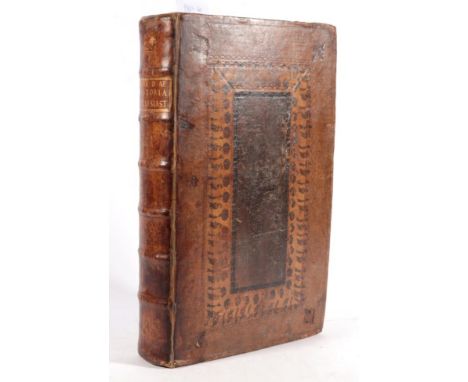
![Pardoe, Julia (text); Bartlett, William H. (ilus.) The Beauties of the Bosphorus. Virtue & Co., [c.1854]. with Beattie, W](https://cdn.globalauctionplatform.com/4102523d-e7ad-401c-b027-a96c010bc098/34262530-1434-46c9-851f-a9b300936aeb/468x382.jpg)

Pardoe, Julia (text); Bartlett, William H. (ilus.) The Beauties of the Bosphorus. Virtue & Co., [c.1854]. with Beattie, William (text); Bartlett, William H. (illus). The Danube. Virtue & Co., [c.1854]. 4to (2 vols). Uniformly bound in likely-contemporary full green coarse-grain morocco gilt, boards with elaborate gilt floral block, spines gilt in compartments, lettered directly in one in each, gilt roll-tooled board edges, gilt roll-tooled turn-ins, a.e.g. yellow endpapers, red silk markers; pp. I: [4], [i]-xii, [3]-172, II: [v]-vi, [1]-236; I: port. front., eng. title, map, 85 plates, II: port. front., eng. title, 2 maps, 80 plates. These are likely the reissues of the original titles post the Crimea War as the Bosphorus is expanded with the appendix and additional plates relating to sites of Crimean interest.Bindings rubbed and scratched with some rubbing away of leather, spotting to endpapers, occasional foxing internally but a very good set in a handsome binding.
We found 109182 price guide item(s) matching your search
There are 109182 lots that match your search criteria. Subscribe now to get instant access to the full price guide service.
Click here to subscribe- List
- Grid
-
109182 item(s)/page
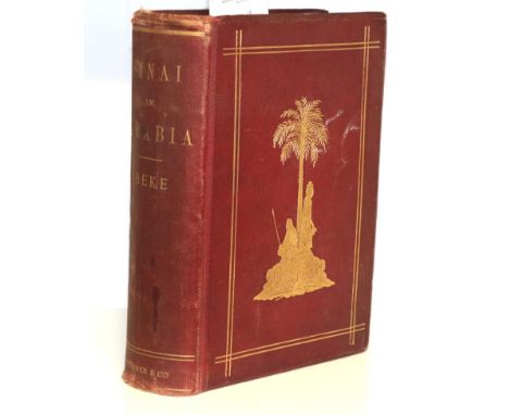
Beke, Charles The Late Dr Charles Beke's Discoveries of Sinai in Arabia and of Midian. Trubner & Co., 1878. 4to, org. red pebbled cloth, upper board with dual-ruled gilt-fillets enclosing central gilt block, lower board with fillets in blind, spine lettered in gilt, a.e.g.; pp. xviii, [2], 606; port. frontis., 13 wood-engr. plates, 2 geological sections,1 folding map at rear; provenance: Peter Dowding Prankerd (Bristol-born land developer and mine operator in Australia, bought The Knoll, Sneyd Park on his 1872 return; armorial bookplate to upper pastedown). First edition. Beke undertook his three month journey in 1874 at the age of 73 to locate Mount Sinai (which he believed was in Saudi Arabia). He died the same year after returning to announce the discovery of the capital of Midian. His book was completed by his wife Emily, edited from his letters. Spine a touch dulled with rubbing at head and foot, lower board detached from text block but still attached to spine, variable foxing, a good copy of a major work.
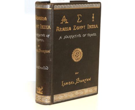
Burton, Lady Isabel A.E.I. Arabia Egypt India. A Narrative of Travel. William Mullan and Son, 1879. 8vo, org. decorative cloth with bevelled edges; pp. viii, 488; coloured map frontis., folding coloured map, 12 b/w plates some likely after drawings by Richard Burton. First edition. Isabel's second book is an account of her 1876 tour of India with her husband, touching on the places seen on the way there and back such as Jeddah and Trieste. Sections of the book (such as the political commentary on the Turkish partition) are generally held to be by her husband.head and foot of spine rubbed and bumped, edges foxed, prelims foxed with offsetting from maps, otherwise a very good copy.
Adanson, Michel A Voyage to Senegal, The Isle of Goree, and the River Gambia. Printed for J. Nourse in the Strand, and W. Johnston in Ludgate Street, 1759. 8vo, full calf, spine with morocco lettering-piece; folding map. First English edition (translated from the French). Adanson was an early proponent of the inheritance of acquired characters and a proto-evolutionist (although rejecting the concept of 'species'). This work comes from his five years in Senegal, mapping, exploring, recording, and collecting plants and animals.Binding scuffed and cracked, some marking and spotting internally but else very good.
Dalzel, Archibald The History of Dahomy an Inland Kingdom of Africa. Printed for the Author by T. Spilsbury & Co., 1793. 4to, calf-backed marbled boards by Poole and Harding, Chester, spine with morocco lettering-piece, marbled edges, marbled endpapers; folding map and 6 plates; provenance: Eyarth House (armorial bookplate to upper pastedown). First edition. Dalzel was born Dalziel and trained as a doctor, but changed his name after losing his fortune to a privateer and being made bankrupt. This trend to failure seems to have attended all his efforts (bookseller, wine merchant, pirate, and slave trader) except for the historical legacy left by this book. Despite being a straight apology for the slave trade (with the intriguing argument that taking slaves saved them from grisly execution instead) it is still widely praised as an acutely observed and seriously intended history of the Kingdom of Dahomy. At a time when the non-European cultures were seen as less advanced or important this book dealt fairly and fully with the customs and manners of the one African kingdom with which Europeans had direct contact for its entire history. Dalzel does not shrink from reporting the brutal nature of justice and warfare, and certainly is not slow to condemn viciousness, but he is also ready to remind the reader of the refined cruelty of cultures seen as more civilised. A fascinating and still authoritative account, which is amongst the best 18th-century histories of Africa.Binding a little rubbed and scuffed but still tight, clean internally, barring a musty air a very good copy.

Catlin, George Letters and Notes on the Manners, Customs, and Condition of the North American Indians. Published by the Author at the Egyptian Hall, Piccadilly, [1892]. 8vo (2 vols). Green cloth; I: frontis., folding map, 74 plates after paintings by Catlin; II: 2 maps, 102 plates after paintings by Catlin, all present by numbering. Reprinted from the original self-published 1841 edition plates (bearing 1841 date on title). A hugely important source on Native American culture. Catlin gave up his law practice to become a self-taught artist. Fascinated by Native American culture he sketched hundreds of scenes and gathered artefacts which he later displayed at his Indian Gallery. Whilst some of his claims have been challenged, the work remains an important historical source for a way of life already vanishing when Catlin began his travels.Bindings scuffed and rubbed with occasional slightly loss, upper cracked but not loose or detached, internally clean. A very good set..
Venerable Bede Historiae Ecclesiasticae Gentis Anglorum, Libri Quinque. Cambridge University Press, 1722. Folio, contemporary Cambridge-style calf, sometime rebacked retaining original spine, spine with morocco lettering-piece, blind-rolled board edges, marbled endpapers, red speckled edges; pp. [16 (half-title, verso blank, title, verso blank, Epistola (4), Praefatio (7), blank)], 823, [14 (Index (13), blank)]; eng. frontis. and 2 eng. plates by Michael van der Gucht, folding map; provenance: this copy was gifted to Ely Cathedral library by John Nichols MA of Trinity College Cambridge, 1730 (gift inscription half-title and title, library bookplate on upper pastedown, occasional mss marginalia), Ely Cathedral library was sold in 1972. The Venerable Bede was the most important English historian of the Middle Ages. His History is perhaps the most important primary source on the Anglo-Saxon period, as well as a critical text in the development of an English national identity through literature. The earliest printed edition was produced in Germany in 1475, with various editions after that. The editor of this edition was John Smith, Prebendary of Durham Cathedral and Rector of Wearmouth - the site of Bede's monastery. It appears that, like many Anglican clergy of the time, his duties were not so onerous as to prevent the pursuit of academia, in this case a magisterial new edition of the text. Prior to this edition, all printed versions of Bede had drawn on a specific family of manuscripts, known as the C-texts. This edition was able to use the Moore MS (one of the earliest extant versions), as well as two copies in the Cotton Library, which greatly improved the quality of the text. Earlier additions had accumulated many errors, which Smith intended to remove by comparison to the earlier versions. Early on in his work, he realised that the wide variety would swamp his version with variants. As such he employed a strict priority, slicing away later material to find a critical text within. The Smiths' passage on methodology contains a vital maxim for manuscript study - remove readings only found in later passages, restore those from the oldest. Smith also included King Alfred's Saxon paraphrase of the text (in a new type, cut specially for the work), a map of Saxon Britain, and printings of a series of Anglo-Saxon charters from Mercia, manuscripts of which no longer exist. The elder Smith worked continually on the text but did not live to see its completion, handled by his son George. Between them they created a version of the text so rigorous that textual criticism of Bede barely altered until Plummer's 1896 edition. David Douglas (English Scholars) describes it as ''perhaps the most perfect single book of the greatest age of Anglo-Saxon historical learning.''Binding slightly scuffed and rubbed, variable lower marginal staining P1-Q1, short marginal tear 3B1 not affecting text, short inner margin tear to folding map affecting image, 7P1 short upper marginal tear affecting text, some slight marking and foxing internally but otherwise clean. An attractive copy.

John Berry (British, 1920-2009) Four original Ladybird gouache and watercolour on board illustrations from The Public Services- Gas, Series 606E, Book No. 2 comprising 'North Sea Map'; 'Floating Platform'; 'Infogram Gas Works' and 'Earth Layers'; all 26.9cm x 17.7cm; published by Wills & Hepworth, 1967. together with: The Public Services- Electricity, Series 606E, Book No. 1 comprising 'Reservoir', 26.9cm x 17.7cm, published by Wills & Hepworth, 1966 and four original Ladybird gouache & watercolour on board illustrations from Public Services- The Mines- Funnel and In the Mine; together with The Road Makers- Boring Holes and Coating the Road; published by Wills & Hepworth, 26.5cm x 17.5cm (9) Artists' Resale Rights/Droit de Suite may apply to this lot, please refer to our Terms of Business

The Oarsman's and Angler's Map of the River Thames from its source to London Bridge, One inch to a Mile. James Reynolds & Sons, 1881. Concertina-folded strip map laid down on linen, in purple board folder, hand-coloured, with accompanying text laid down on flap of folder, with pencil MSS annotations around Medenham.Boards a little scuffed but clean map.

Coal Mining Derbyshire & Nottinghamshire Coalfield, Map showing the Colliery Royalties, the positions of the Pits, Coke Ovens, and the Roads and Railways serving the District. Cardiff: Business Statistics Company Ltd., [1934]. Coloured map, dissected and laid down on linen, in green folder, lettered in gilt. Based on the OS maps with permission.

English, Thomas H. An Introduction to the Collecting and History of Whitby Prints. Whitby: Horne & Son., 1931. 4to (2 vols). Org. white cloth, upper boards with arms of Whitby Abbey in gilt, spines lettered directly in gilt; I frontis., folding map of Whitby on linen, plates of the prints with accompanying text; II: plates of prints with accompanying text; both vols with head- and tail-pieces and blank pages for each letter for the collector to add their own discoveries. Vol. II has an additional addenda of unclassified prints and a diary of Whitby events. Limited edition, this no. 40 of 210, signed by author on limitation page.

Farquharson, Mr. (short-hand notes) In the King's Bench between Thomas Redford, Plaintiff; and Hugh Hornby Birley et al, Defendants. Report of the Proceedings on the Trial of this Cause at Lancaster. Manchester: C. Wheeler and Son, Chronicle Office, [c.1822]. 8vo, half leather; pp. [4], xx. 632; folding map frontis; provenance: Thomas Burgess, Morton Hall, Brighouse (owner's bookplate to upper pastedown) Thomas Redford brought suit against Birley and other defendants for injuries suffered during what would become known as the Peterloo Massacre. Whatever the truth and reality of the Massacre, it became a contentious rallying cry for both sides in the debate about Parliamentary Reform. The Reformers, who had been attacked by the Yeoman Cavalry (suffering 18 deaths and many injuries) saw it as another sign of governmental repression tied into class distinctions, labour laws and religious dissent. The government saw this as clear evidence of dangerous radical opposition threatening the social fabric. In the aftermath Redford brought suit against his attackers to attempt to draw attention to the violence of the day. However, in the end the jury found the defendants had acted lawfully in response to unlawful assembly. In a crowning act of arrogance, the government paid their costs. Reformer politician Henry Hunt, and the Manchester Observer, both called it a ''sham trial'' but it still quietened much of the outrage over the events of the day, and with it the growing popular Radical movement in Manchester and Lancaster. Interestingly echoes continue to survive: one of the knee-jerk laws enacted after the massacre - that outlawing ''Unlawful Drilling'' - was only repealed in a general Parliamentary repeal in 2008. A significant primary source on a major event in the history of Parliamentary reform and popular political action.Spine lacking but boards still attached, otherwise very good.

Fosbroke, Revd. T.D. The Wye Tour or Gilpin on the Wye. Ross: Printed for and Sold by W. Farror, 1818. 16mo, full calf, boards with double gilt-fillet borders, flat spine ruled and lettered directly in gilt, gilt roll-tooled board edges, gilt roll-tooled turn-ins, endpapers marbled over text; port. Frontis., map, 2 plates.Boards a little rubbed and scuffed, some slight spotting and foxing (more to pre- and postlims).
Drummond, William Hamilton The Giant's Causeway, A Poem. Belfast: Printed by Joseph Smyth for Longman, Hurst, Rees, Orme & Browne, London et al, 1811. 8vo, red half leather; pp. [i-v], vi-xxvii, [1 (errata)], [1-3], 4-204; 2 map frontis (one folding), 6 plates (3 folding). First edition. A historical, mythological, scientific poem on the Causeway with extensive notes to each of the three books of the poem at the rear.Binding scuffed but still solid, some light foxing and offsetting, pp. 136-7 with marginal marking and spotting, more foxing towards end of book.


Speede, John The Countie of Westmorland and Kendale the Chief Towne Descibed. George Humble in Pope's Head Alley against The Exchange, [c.1627]. Framed and glazed, mounted double-sided with no glass to rear, uncoloured.Glass a little loose in frame, evidence of restoration to rear, map a little creased.


Andrews, John and Dury, Andrew Topographical Map of Wiltshire. Published by Andrews and Dury, in Duke's Court, St. Martin's Lane, London, 1773. On 19 sheets bound in half leather over marbled boards, upper board detached, hand-coloured in outline.Upper board detached, binding worn, edges a little crumpled and dirty, some slight, occasional, foxing but generally still bright.
![Sanson, Nicholas and Guillaume L'Europe. Paris: Chez L'Autheur Avec Privilige de S. M[ariette], dated in plate 1669, but like](https://cdn.globalauctionplatform.com/4102523d-e7ad-401c-b027-a96c010bc098/b5f2385b-4733-49f1-af1c-a9b900a34b4d/468x382.jpg)
Sanson, Nicholas and Guillaume L'Europe. Paris: Chez L'Autheur Avec Privilige de S. M[ariette], dated in plate 1669, but likely after 1674. Framed and glazed, hand-coloured in outline. Nicholas entered into commercial agreement with Pierre Mariette in 1644. Sanson acquired the rights and drew the maps and Mariette engraved the plates and printed the maps. The two divided the plates between them, but Sanson stored some of his with Mariette and they were marked with the Mariette address. After Mariette's death in 1657 his son took over. Sanson claimed there had been abuses of license, a dispute which continued after his death in 1667 until the two men's sons settled it in 1674. After this date the imprints on the returned plates were changed from Chez Mariette to Chez l'Autheur, as can be seen on this map.
![Pagani (Domenico) [Map of the Western Part of the Balkan Peninsula] Carte delle Provincie Illiriche co' loro diversi stabili](https://cdn.globalauctionplatform.com/4102523d-e7ad-401c-b027-a96c010bc098/36bb3f04-1db4-4f5f-ba91-a9ba00c06b0d/468x382.jpg)
Pagani (Domenico) [Map of the Western Part of the Balkan Peninsula] Carte delle Provincie Illiriche co' loro diversi stabilimenti ... Compilata per ordine superiore nel deposito della guerra del regno d'Italia nell'anno MDCCCXIII [1813], Milan, G. Bordiga: engraved map with hand colouring in two parts on a total of 16 linen-backed sections, folding into original marbled slipcase with label preserved. The whole approx. 1030 x 1080mm. Slipcase frayed and splitting at joints, map a little foxed. An interesting map produced for military strategy during the Napoleonic Wars. Illyria, the name originally given to a Roman province in the western Balkans, was revived by Napoleon as the Illyrian Provinces, which he incorporated into the French Empire from 1809 to 1813. [together with:] Scheda (Josef von, Publisher) [Map of Europe] General-Karte von Europa in 25 Blattern, 1859, Vienna, complete with key plate and 25 colour lithographic folding sheets, each linen-backed and labelled with numeral, forming a map approx. 2025 x 2450mm, in dark leather-covered bookform box, red morocco spine with gilt lettering. Spine splitting, box rubbed and frayed at edges, map foxed (2).
![Robert de Vaugondy (Gilles) L'Empire du Japon, [later than 1750], glazed and framed, hand-coloured in wash and outline. Datin](https://cdn.globalauctionplatform.com/4102523d-e7ad-401c-b027-a96c010bc098/7a869272-7e0e-4c10-8007-a9b900a34cb7/468x382.jpg)
Robert de Vaugondy (Gilles) L'Empire du Japon, [later than 1750], glazed and framed, hand-coloured in wash and outline. Dating from the height of French cartography this map was the work of Gilles Robert de Vaugondy, a descendant of the great, precise cartographer Nicolas Sanson. Gilles inherited the family firm in 1730, enlarging the stock by purchasing the estate of another great cartographer, Hubert Jaillot. He would be honoured in 1730 with the title of Cartographer to the King. This map was first produced in 1750, revising material from the firm's stock. Critically Gilles excluded the fictional island of Matsumae, a common error on European maps of the time, and brought a previously unknown accuracy to the work which maintained its reputation into the 19th century. Despite all this Hokkaido ''Terre D'Yedso'') is strangely depicted as a somewhat vague addition off the coast of Honshu.


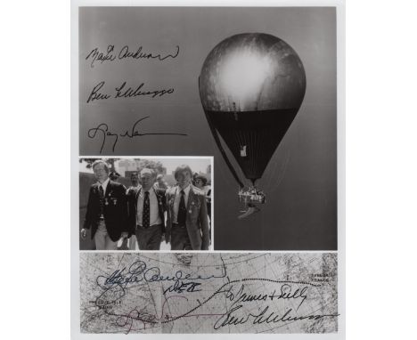
DOUBLE EAGLE II: Signed and inscribed 8 x 10 photograph by all three crew members of Double Eagle II individually, comprising Ben Abruzzo, Maxie Anderson and Larry Newman, being the pilots of the first balloon to cross the Atlantic Ocean, 1978. The composite image depicts the balloon in flight, a map charting the route of the historic flight and an image of the three crew members in three quarter length poses together. Signed by each in black inks to the base of the image, Abruzzo adding an inscription in his hand and Anderson adding DEII in his hand beneath his signature. The image also features facsimile signatures of each of the crew. Autographs of Abruzzo are scarce following his untimely death in an airplane crash. VG
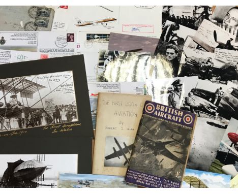
AVIATION: Selection of various air force and space flight ephemera and collectables, including printed R.A.F. flight documentation, a Fleet Air Arm Meteorologist Sleeve Badge, commemorative postal covers celebrating various aviation anniversaries, postcards and photographs depicting aircraft, pilots and astronauts, reproduction photographs of German Luftwaffe personnel of World War II, printed aviation newsletters and programmes, a selection of metal and plastic toy aircraft (some damaged), part of the original main spar from the Avro Lancaster PA 474 (limited edition of 1000 pieces), Air Training Corps Gazette, February 1943, The Aeroplane Spotter, January 1945, Flight, October & November 1909, The Aeroplane, November 1911, a boxed video history of the R.A.F. presented by Richard Todd, an unconstructed Revell 1:72 model of the Avro Lancaster "Dam Buster", an unidentified Aeroplane Log Book, a souvenir ticket made of metal from one of the crashed gliders which carried the British 1st Airborne Division into battle at Arnhem, a facsimile hardback edition of the Flying Log Book of Wing Commander Robert Stanford Tuck (limited edition 445/2500), a set of Churchman cigarette cards, The R.A.F. at Work, a map of Great Britain displaying aeronautical information, September 1948 etc. Generally G to VG, 161


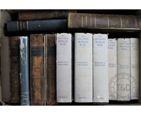
RAYMOND (G), THE NEW UNIVERSAL AND IMMPARTIAL HISTORY OF ENGLAND, engraved plates, poor condition map by Bowen, London, Cooke, THOMPSON (R), THE GARDENERS ASSISTANT, with hand coloured plates, London, Blackie, c1858; CRANE (W), illus, PAN-PIPES, pictorial boards; ASPLAND (A), THE GOLDEN LEGEND, Holbein Society, 1878; CHURCHILL (W), THE SECOND WORLD WAR, 1948-1954; LAURO DE BOISIS, ICARO, translated and signed by Ruth Draper to Anthony Pearce, dated Cape Town Dec 18th 1933; and other bindings (Qty)


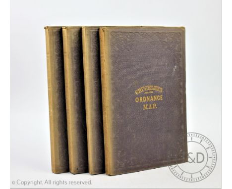
CRUCHLEYS REDUCED ORDNANCE MAP OF ENGLAND AND WALES, four large folding linen backed maps comprising Shropshire and surrounding counties(30, 31, 36, 37,), another centred around Huntingdonshire (32, 33, 38, 39), one entered round London (19, 20, 26, 27) and a map centred around Bristol (17, 18, 24, 25)


LEIGH (C), THE NATURAL HISTORY OF LANCASHIRE, CHESHIRE AND THE PEAK IN DERBYSHIRE, engraved portrait frontis, folding map with hand coloured detailing and twenty four engraved plates, three parts in one, re-backed calf with original tan boards, frontis and title cut and re-laid, Oxford, 1700 (1)

MOGG (E), PATTERSONS ROADS, being an entirely original and accurate description of all the direct and principle cross roads in England and Wales, 7th edition, folding frontis map, map of London to Hollyhead and seven folding maps at rear, later 1/2 calf with original boards, and brass clasp, London, 1824 (1)


A 1950's Philips 10 inch Challenge Globe, on square base, 31cm high CONDITION REPORT: Crazed throughout with some browning down the join lines of the map and some losses to the paper at the joins - heaviest to the equator in South America - slight gapping to the equator at the Atlantic. A couple of odd blemishes. Meridian lightly grubby. Overall fair.


SPEKE, John Hanning, Journal of the Discovery of the Source of the Nile, London 1863, 1st edition, 8vo original cloth, cloth worn and discoloured, content detached from case, lacks map of Eastern Equatorial Africa which should be in rear pocket, all illustrations and the other map are present (1)

An unframed map of the Parish of St Mary, Whitechapel, two unframed maps showing allied progress on the Western Front, an Ogilby 1698 route map, together with a large quantity of unframed maps relating to Hertfordshire. Condition Report: We believe this to be original 1698, with later colour added. Overall good condition. Evidence of crease top to bottom centre.
-
109182 item(s)/page