We found 109198 price guide item(s) matching your search

Refine your search

Year

Filter by Price Range
  • List
  • Grid
  • 109198 item(s)
    /page

Lot 736

INDONESIA -- "OOST JAVA". (The Hague), Topographische Inrichting, 1906. Autotype cold. map. 655 x 920 mm. (A bit creased on ends of central vertical fold, some pin holes in margins, else in good condition). -- Added: "KAART VAN DE WESTERHELFT (& OOSTERHELFT) der Residentie Timor". Batavia, Van Haren Noman & Kolff, 1860. 2 lithogr. maps by W.F. Versteeg after J.C.R. Steinmetz. 330 x 390 mm each. -- And 2 rail and tramway maps of Java. (4). NOTE:Ad 1: Map of East Java with legend and inset maps of the area around Surabaya, the Kangean Islands and the island of Bawean. Numbered top left: 5. With graduations along the edges.

Lot 737

LOW COUNTRIES -- "XVII. PROVINCIÆ Belgii sive Germaniæ Inferioris (…)". (Augsburg, M. Seutter, c. 1740). Engr. map in cont. col. 500 x 594 mm. (Central vertical fold, some marginal splits in places). -- Added: "ULTRAIECTINI DOMINI tabula". Amst., F. de Wit, (c. 1680). Engr. map in cont. col. 476 x 573 mm. -- And 6 o. 'provinces', comprising maps by Hondius (2x), Visscher, De Wit, Kaerius, Metius & Freytag. (8).

Lot 745

LOW COUNTRIES -- "BELGICA FOEDERATA complectens Septem Provincias (…)". Augsb., T.C. Lotter, (1761). Cold. engr. map by M.A. Lotter. W. intricate and large allegorical cartouche displaying i.a. the coats of arms of the provinces and w. a scale indicator within separate cartouche. 475 x 580 mm. (Colour a bit ran out in places, but in good condition). -- Added: "NIEUWE KAART van Holland" - NIEUWE KAART van Groningen" - "NIEUWE KAART van Gelderland" - NIEUWE KAART van Friesland" - "NIEUWE KAART van Utrecht" - "NIEUWE KAART van de Provincie Zeeland". - 1781-97. Tog. 6 cold. engr. maps by Klockhoff, Van Jagen (2x), Krevelt (2x), and Van Baarsel. Each c. 340 x 425 mm. Taken from Kok's Vaderl. Woordenboek. (1st mentioned a bit stained, 5th mentioned a bit browned). -- (7).

Lot 746

LOW COUNTRIES -- "CHARTE VON HOLLAND, nach richtigen astronomischen Beobachtungen , (…) gezeichnet von Tobias Mayer". Nürnberg, Homanns Erben, 1811. Engr. cold. map. w. inset map of 'Ostfriesland' and 4 scale indicators. 485 x 535 mm. (Stained in left and right outer margins (partly in image)). Rare. -- Added: "A NEW AND CORRECT MAP of the Seven United Provinces (…)". (1747). Cold. engr. map after E. Bowen. 355 x 432 mm. Not in V.d. Heijden. -- And 2 similar maps (Homann Heirs, 1748 and Jaillot/Covens & Mortier (2nd h. 18th c.). (4).

Lot 758

LOW COUNTRIES -- "GERMANIÆ INFERIORIS XVII PROVINCIARUM accur. tabula. Nunc apud Petrum Schenk Jun." (Amst., N. Visscher/P. Schenk, c. 1726). Engr. map w. faint colouring. 470 x 570 mm. NOTE:V.d. Heijden 126, 4th state.

Lot 759

LOW COUNTRIES -- GEVERS (v. ENDEGEEST), D.T. (Verhandeling over het toegangbaar maken der duinvalleijen langs de kust van Holland). 5 (of 10) maps by D. Veelwaard & Son, numbered 1-2, 4-6 and dated 1825, depicting in detail the dune area roughly between The Hague and Schoorl. Various sizes, but 3 maps c. 345 x 720 mm, and 2 c. 345 x 480 mm each. (In fine condition, w. ample margins, all w. central vertical fold, map 5 w. some small rep. on v°). NOTE:Present: "Kaart der Waalsdorpsche afwatering i.d. gemeenten 's Hage en Wassenaar" - "Kaart der Berkheysche afwatering i.d. gemeente Wassenaar en Katwijk" - "Kaart der afwatering v. Soersaap i.d. gemeenten Bloemendaal en Velsen" - "Kaart v.d. Hoep-Beeksche afwatering i.d. gemeenten Heemskerk, Castricum en Egmond" - "Kaart der afwatering v. Bergen i.d. gemeenten Bergen en Schoorl". Text-vol. not present.

Lot 760

LOW COUNTRIES -- HAARLEMMERMEER -- "KAART VIII. Verkaveling van den Haarlemmer Meer Polder". 's-Grav., E. Spanier, n.d. (between 1852-60). Lithogr. map divided in 2 sections: left the Haarlemmermeer and right hydraulic details, cold. by hand w. blue colour wash. 545 x 722 mm. (4 small tears on central fold, but without loss of image). -- Added: "KAART VAN DE GEMEENTE HAARLEMMERMEER" (&) "STAAT DER VERKOCHTE PERCEELEN". Rott., Van Gogh & Oldenzeel, 1855. Plain lithogr. map and list of names of buyers. 515 x 418 mm. -- And: "AFBEELDINGE VAN RHYNLANDS WATERSTAAT ten Opzigte van 't Vergrooten der Haarlemmer of Leydse Meer (…) volgens Meetinge A° 1739 en 1740 gedaan bij mij (…) M. Bolstra". (1746). Engr. map w. title cartouche, compass rose and scale indicator. 548 x 629 mm. (Margins a bit frayed/dam.). -- And 3 o. in relation to the Haarlemmermeer. (7).

Lot 762

LOW COUNTRIES -- "HOLLANDIÆ COMITATUS una cum Ultrajectino Dominio nec non Maximis Partibus Geldriæ Ducatus, per C. Specht". Amst., R. & J. Ottens, n.d. (between 1725 and 1750). Engr. map, cold. in outlines by hand. 510 x 570 mm. NOTE:In fine condition. Blonk-v.d. Wijst 77 (2nd state).

Lot 763

LOW COUNTRIES -- "ILLUSTRIBUS AC POTENTIBUS COMITATUS DRENTIÆ (…)". (Amst., Hondius), 1634. Engr. cont. handcold. map. 380 x 490 mm. (2 tears running into image rep. on v°, slightly soiled but in good condition). -- Added: "FRISIA OCCIDENTALIS". Amst., H. Hondius, (c. 1640). Auctoribus A. Metio et G. Freitag. Amst., H. Hondius, (c. 1630). Engr. cont. handcold. map. 396 x 505 mm. (Small rep. to margins in places, but in good condition). -- (2). NOTE:Ad 1: Donkersloot-De Vrij 701; V.d. Krogt 3850:1A.1. - Ad 2: V.d. Krogt 3910:1.1. - Both w. French text on v°.

Lot 764

LOW COUNTRIES -- "KAART DER BATAAFSE REPUBLIEK verdeeld in departementen en ringen (…)". Den Haag, J.C. Leeuwestijn, 1799. Map by Q. Ondaatje, engr. by C. v. Baarsel. 505 x 398 mm. -- And 3 similar of the Batavian Republic, of which 2 cold. (Van der Heijden, 4, 26 and 1 o. not listed in V.d. H.). (4). NOTE:Ad 1: Koeman, Geschied. v.d. kartografie, p. 183: "De vindingrijke Ondaatje (…) bracht een kruising tussen een tabel en een kaart tot stand (…)". In fine condition. Signed by Ondaatje underneath the impressum. - Van der Heijden, 12 (at length); Atlas v. Stolk 5435.

Lot 765

LOW COUNTRIES -- "KENNEMARIA et WESTFRISIA vulgo et vernaculé Noord-Holland (…) ed. p. N. Visscher (…)". (Amst.), P. Schenk jr., n.d. (2nd/3rd quarter 18th c.). Engr. map, cold. by hand, w. 2 large elaborate cartouches (i.a. w. coats of arms) in lower right and upper left corners. 572 x 493 mm. NOTE:In very fine condition and beautifully coloured. Werner, De Atlas der Neederlanden, nr. V:16.

Lot 766

LOW COUNTRIES -- "KENNEMARIA et WESTFRISIA vulgo et vernaculé Noord-Holland (…) ed. p. N. Visscher (…)". Amst., N. Visscher, n.d. (after 1682). Plain engr. map, w. 2 large elaborate cartouches (i.a. w. coats of arms) in lower right and upper left corners. 572 x 493 mm. Framed, glazed and under passepartout. NOTE:Uninspected out of frame. Koeman, Atlantes Neerlandici, dl. III, p. 182 (nr. 188).

Lot 768

LOW COUNTRIES -- KRIMPENERWAARD -- "HOOGE HEEMRAADSCHAP, Het, VANDE CRIMPENRE WAARD". (The Hague, G. v. Moelingen & J. Gijseman), 1755. Tog. 18 sheets: 6 double-p. engr. maps (the map alone: 105 x 147 cm), 4 engr. w. large coats of arms including the title banner, and 8 engr. w. large coats of arms which form - conjoined - a large wall map (tog. 155 x 195 cm). (Traces of use, some rep. to splits in places, espec. maps show some light staining/thumbing, but over all in fair condition). NOTE:Impressive polder map of the Krimpenerwaard. Donkersloot-de Vrij, 766 distinguishes 8 editions of this polder map of which this is the 6th edition, dated in the plate 1755. Each edition was printed in c. 200 copies. The surveyor was Johannes Leupenius.

Lot 773

LOW COUNTRIES -- LEIDEN -- "LEYDA, BATAVORUM LUGDUNUM, vulgo Leyden, Anno 1574". (Cologne, Braun & Hogenberg, between 1572 and 1618). Engr. bird's eye view on the city from the South, cold. by hand. 345 x 478 mm. Latin text on v° "Leida, (etc.)". (A few tiny marg. tears, slightly browned). NOTE:Map of Leiden in bird's eye perspective depicting the city and all its surrounding villages from the south on October 3rd 1574. White marks on the map represent the flooding that was going on and Spanish soldiers can be seen fleeing for the protestant troops. - Overvoorde, 35; cf. Groenveld p. 38 ff: Hans Liefrinck en zijn kaarten v. Leiden, 1574, 1576, 1580.

Lot 775

LOW COUNTRIES -- LEIDEN -- "LEYDA, BATAVORUM LUGDUNUM, vulgo Leyden, Anno 1574". (Cologne, Braun & Hogenberg, between 1572 and 1618). Engr. bird's eye view on the city from the South, cold. by hand. 345 x 478 mm. Framed & glazed. Uninspected out of frame. Groenveld/Van Maanen/Penning, Lei 002, I. -- Added: "DELFLANDIA, SCHIELANDIA, et insulæ trans Mosam illis objacentes ut sunt Voorna, Overflackea, Goerea, Yselmonda, etc." (Amst.), W.J. Blaeu, (c. 1635). Engr. map in cont. col. 392 x 502 mm. Framed & glazed. (Colours faded, some foxing). -- (2).

Lot 779

LOW COUNTRIES -- MANUSCRIPT MAP OF RIVER DE LEK and surroundings, roughly from Wijk bij Duurstede ? to Ameide ?. N.d., but watermark before 1738. Drawing in black ink and colour wash. 485 x 690 mm (paper size). Hinged to mount, under passepartout. NOTE:Anon. drawing before lettering with coat of arms of Utrecht within elaborate cartouche in right lower corner.

Lot 781

LOW COUNTRIES -- "NIEUWE KAART der Bataafsche Republiek verdeeld in VIII departementen, volgens de acte van staatsregeling, voor het Bataafsche volk". Amst., Mortier, Covens & Zoon, 1798. Engr. map printed on thick paper in cont. colouring and w. cold. numbers as it should be. 472 x 602 mm. (2 small rep. on v°-side, else very good). NOTE:As Van der Heijden, Kaart v. Nederland i.d. Franse tijd, 10, 2nd state, but w. year '1798' in stead of '1796'.

Lot 784

LOW COUNTRIES -- "NOVISSIMA & ACCURATISSIMA XVII Provinciarum Germaniæ Inferioris Delineatio". (Amst.), N. Visscher, n.d. (between 1656 and 1663). Fine cold. engr. map by A. Deur w. 2 fine large cartouches, compass rose and scale indicator. 475 x 570 mm. Framed, glazed and under (double) passepartout. NOTE:Uninspected out of frame. Van der Heijden 126 (first state).

Lot 790

LOW COUNTRIES -- ROTTERDAM -- "ROTTERDAM". Rott., Arbon & Krap, 1824. Engr. plan of the city by D. Sluyter and C. v. Baarsel & Son, printed on silk (!). 430 x 535 mm. W. 2 scale indicators, inset map w. compass needle pointing North, and index in 3 languages, numbered 1-84. Folded in 32 sections. (Some mild foxing on one of the central folds, but in very fine condition). NOTE:Roterodamum Illustratum 55. Rare.

Lot 792

LOW COUNTRIES -- UTRECHT -- "EPISCOP. ULTRAIECTINUS auct. B. Florentio a Berkenrode". (Amst.), 'Ex Off. Janssonio-Waesbergiana, Mosis Pitt, et Stephani Swart', (ca. 1680-83). Cold. engr. map. 375 x 490 mm. Framed, glazed and under passeprtout. NOTE:Fourth state (of 4). V.d. Krogt 3660:1.4.

Lot 793

LOW COUNTRIES -- UTRECHT -- "ULTRAIECTUM DOMINIUM". (Amst.), W.J. Blaeu, (1663). Cold. engr. map. 390 x 516 mm. French text on v°. (In good condition w. ample margins). -- Added: "DELFLANDIA, SCHIELANDIA, et insulæ trans Mosam illis objacentes ut sunt Voorna, Overflackea, Goerea, Yselmonda, etc." (Amst.), W.J. Blaeu, (1635). Engr. map in cont. col. 392 x 502 mm. Latin text on v°. (Upper (blank) margin faintly stained). NOTE:V.d. Krogt 3660:2:611 & 3402:2:101.

Lot 794

LOW COUNTRIES -- ZEELAND -- "CAARTE van Sinte Cornelis Polder anders de Quacq". (Amst., 1701). Plain etched map by J. Luyken and I. Stemmers after A. Steyaart. c. 500 x 705 mm. W. large cartouche and compass rose. Recently framed, glazed and under passepartout. NOTE:From: VOORNE CAART-BOECK Van alle Dorpen, en Polders gelegen Inden Lande van Oost, ende West Voorne, Mitsg. Over Flacqueé (…). N.pl., 1701. Uninspected out of frame, but in perfect condition. - Donkersloot-de Vrij, 247; Van Eeghen/v.d. Kellen, 370; Landwehr, RdeH, 97; Van Nierop, RdeH, 1701.08.

Lot 795

LOW COUNTRIES -- ZEELAND -- "CAARTE vande Polder van Nieuw-Hellevoet". (Amst., 1701). Plain etched map by J. Luyken and I. Stemmers after A. Steyaart. c. 500 x 705 mm. W. large cartouche and compass rose. Recently framed, glazed and under passepartout. NOTE:From: VOORNE CAART-BOECK Van alle Dorpen, en Polders gelegen Inden Lande van Oost, ende West Voorne, Mitsg. Over Flacqueé (…). N.pl., 1701. Uninspected out of frame, but in perfect condition. - Donkersloot-de Vrij, 247; Van Eeghen/v.d. Kellen, 370; Landwehr, RdeH, 97; Van Nierop, RdeH, 1701.08.

Lot 796

LOW COUNTRIES -- ZEELAND -- "CAARTE vande Polder van Oost Voorn". (Amst., 1701). Plain etched map by J. Luyken and I. Stemmers after A. Steyaart. c. 500 x 705 mm. W. large cartouche and compass rose. Recently framed, glazed and under passepartout. NOTE:From: VOORNE CAART-BOECK Van alle Dorpen, en Polders gelegen Inden Lande van Oost, ende West Voorne, Mitsg. Over Flacqueé (…). N.pl., 1701. Uninspected out of frame, but in perfect condition. - Donkersloot-de Vrij, 247; Van Eeghen/v.d. Kellen, 370; Landwehr, RdeH, 97; Van Nierop, RdeH, 1701.08.

Lot 797

LOW COUNTRIES -- ZEELAND -- "COMITATUS ZELANDIÆ novissima delineatio". (Amst., P. Schenck, c. 1670?). Engr. map in cont. col. by N. Visscher. 460 x 550 mm. -- Added: "INSULA VALACHRIA in Comitatu Seelandia". (Augsb., T.C. Lotter, after 1757). Engr. map in cont. col. by G.F. Lotter. 485 x 575 mm. -- (2). NOTE:Ad 1: 4th state w. address of P. Schenck. Blonk-v.d. Wijst, 42.4. -- Ad 2: In fine condition. Blonk-v.d. Wijst, Walcheren, 5.

Lot 798

LOW COUNTRIES -- ZEELAND -- "FLANDRIÆ COMITATUS PARS BATAVA, (…)". Amst., N. Visscher, (1675). Plain engr. map. 486 x 545 mm. Blonk-v.d. Wijst, Zeeuws Vl., 3 (first state). -- And 3 o. (4).

Lot 799

LOW COUNTRIES -- ZEELAND -- "KAART St. JAN of NIEUVLIET". Dated 1779. Large cold. manuscript map by Willem Pleijte Wzn. of the polders around Nieuwvliet, drawn on vellum, w. compass rose and scale indicator. c. 735 x c. 1000 mm. (Image (a bit) faded, but in good condition). NOTE:Nieuwvliet has always been a domain. The first lord was Jan Adornis, a Bruges merchant who in 1527 diked the Sint Janspolder, a polder in the 'Zwarte Gat' between the 'Eiland van Groede' and the 'Eiland van Cadzand'. He founded the high lordship, in which the older lords of 'Nieuwvliet', 'Sint-Pieter' and 'Mettenije' were united. In 1529 these united domains were recognized by Emperor Charles V. The three former domains were represented in the coat of arms of Nieuwvliet by three crescent moons.

Lot 801

LOW COUNTRIES -- ZEELAND -- "ZEELANDIA COMITATUS". (Amst., W.J. Blaeu, 1635). Engr. map in cont. col. 387 x 502 mm. -- Added: "COMITATUS ZELANDIÆ novissima delineatio". (Amst., c. 1670?). Plain engr. map by N. Visscher. 460 x 550 mm. -- (2). NOTE:Ad 1: First state. Latin text on v°. Blonk-v.d. Wijst 31.a. -- Ad 2: Strong impression and in fine condition of the 2nd state. Blonk-v.d. Wijst, 42.2.

Lot 802

LOW COUNTRIES -- ZEELAND -- "ZELANDIA COMITATUS". N.d. (=1633). Cold. engr. map w. cartouche and scale indicator in right lower corner. 350 x 493 mm. German text on v°. Blonk & Van der Wijst, state 9, 2m. -- Added: WALACHRIA" (Walcheren). (Amst., Blaeu, 1662). Plain engr. map w. cartouche and scale indicator. 440 x 550 mm. Latin text on v°. V.d. Krogt 3610:2:601. -- And 1 o. of the Ooster- and Westerschelde. (3).

Lot 805

PLAN DE L'ISLE DE FERNAND NORONHA/Carte de la Partie de l'Ocean Vers l'Equateur entre les Cotes d'Afrique et d' Amerique. Paris, Dezauche, c. 1780. Cold. engr. map by Ph. Buache in 2 sections: left a chart of the South Atlantic, right a chart of the Island Fernand de Noronha. 495 x 645 mm. -- Added: "CARTE PHYSIQUE DE L'OCEAN où l'on voit des Grandes Chaînes de Montagnes qui traversent les Continents (…)". Paris, Buache, 1757. Engr. map, cold. 310 x 355 mm. -- And 4 similar physical geographic maps, incl. 2 publ. by Dezauche. (6). NOTE:Ad 1: This map was issued in a series drawn by Philippe Buache to illustrate his theory of the continuity of mountain chains under the sea.

Lot 823

D'ORBIGNY, A.D. -- COLLECTION of 142 engr./lithogr. plates by A.D. d'Orbigny after E. Lassale (incl. 1 duplicate; 52 in col.) taken from 'Voyage dans l'Amerique meridionale. Par., Pitois-Levrault, 1834-1847'. (Slightly browned, a few stains). NOTE:Vues, 1-24 (2 panoramical views: Valparaiso on 5 plates, Callao on 3 plates); Coutumes & usages, 1-11; Costumes, 1-13 (12 cold.); Antiquités, 1-21 (1 cold.); Géologie, 1-22 & 1 fold. map; Botanique, pt. 1: 1-12 (7 cold.), pt. 2, 1-3; Palmiers, 1-32 (31 cold.); Partie historique, carte 8 & 9. - Selection of plates from Orbigny's monumental work on the anthropology and natural history of South America. - Sabin 57457; Nissen BBI 1471.

Lot 832

HERALDRY -- ("WAPENEN der Steden en Oud-Adelyke Geslachten in de machtige Republyke van Holland en West-Vriesland"). Haarlem, B. Cleynhens, (1695). Heraldic 'map' w. num. plain coats of arms on 4 engr. plates by B. Stoopendael. The plates can be conjoined in such a way that they form one large plate. Without the text-leaf. (Chip in lower blank margin of 1st plate). -- Added: "NAMEN en Wapenen der Ed:Agtbaare Heeren Oudraden ofte Vroedschappen der Stad Dordrecht (…)". Amst., H. de Leth, (1740). Heraldic 'map' w. 228 coats of arms on 2 engr. plates which can be conjoined. (Some brown stains in places). -- "NAMEN ende Wapenen der (…) Heeren , Veertigh Raaden der Stad Delft (…)". (Amst.), H. de Leth, 1738. Heraldic 'map' w. 538 coats of arms on 4 engr. plates. (Some tear & wear in places). -- And 11 o. heraldic and genealogical plates. (21).

Lot 89

REYNKE DE VOS. (Faks. der Ausg. 1498. 1976). Obrds. Printed in 500 numb. copies. -- VAN DEN VOS REYNAERDE. (Verz. d. W.G. Hellinga). Amst., Balkema, 1940 (=1944). Owrps. (Spine strengthened/stained). Printed in red & black. Typography: J. v. Krimpen. -- VAN DEN VOS REINAERDE Crit. uitg. (&) exegetisch comm. d. J.W. Muller. (1e-)3e verm. & herz. dr. 1942-44. 2 vols. W. 18 plates & 1 map. Lge-8°. Ocl. (1 spine a bit faded). -- REYNARDUS VULPES. De Lat. Reinaert-vert. van Balduinus Iuvenis. Crit. uitg. & vert. d. R.B.C. Huygens. 1968. Or. bind. w. dust-j. -- LE ROMAN DE RENART. Éd. publ. p. A. Strubel. (1998). Or. leather w. mylar cover & slipcase. (Bibl. de la Pléiade). -- And 15 o. on the subject. (21).

Lot 899

UTRECHT -- POMPONIUS MELA. De situ orbis ll. III. Cum not. integr. H. Barbari, (...) I. Vossii, et J. Gronovio. Acc. P.J. Nunnesii epistola de Patria Pomponii Melae, (...) et J. Perizonii adnot. ad libri I., cap. 17. Cur. A. Gronovio. Ed. 3a. Leiden, S. Luchtmans, 1782. (22), 1081, (54) pp. W. engr. front., 1 fold. map & 43 text-engr. Cont. vellum w. gilt coat of arms of Utrecht on both sides surrounded by a gilt border. (Ties lack, some minor foxing/browning in places). NOTE:With schoolprize to Hermannus Joannes Roijaards, dated 24 sept. 1807. - Dibdin II, 356; Spoelder 689 (Utr. 9).

Lot 904

BIBLIA NEERLANDICA -- BIBLIA, Dat is, De gantsche H. Schrifture vervattende alle de Boecken des O. ende N. Testaments. Amst., R.D. v. Baardt, n.d. (=1648). 4 parts in 1 vol. W. engr. title (incl. a small portrait of Luther), and 5 double-p. maps (incl. a map of the world) and 1 double-p. plan by C.J. Visscher, all - but the world map - dated 1650. Fol. Cont. russia over wooden brds., sides w. brass bosses, brass clasps and catches. (Some rep. to exterior, some worming in upper blank margin prelims, all plates dam. to some degree and in need of restoration, small corner of blank margin world map missing (not quite interfering w. image), some minor staining in places). NOTE:Revision of the Biestkens Bible, prepared on the basis of Luther's version by Adolf Visscher of the Lutheran Church at Amsterdam. - Darlow & Moule 3311; Poortman, Kaarten in Bijbels, p. 143-9.

Lot 907

BIBLIA NEERLANDICA -- (MARTIN, D.). Historie des Ouden en Nieuwen Testaments. (Vert. d. W. Séwel). Amst., P. Mortier, 1700. 2 vols. (18), 282, (8); (26), 163, (11) pp. W. 2 variant engr. fronts., lge. engr. vign. on each ti., 32 engr. head- & tailpieces, 5 engr. double-p. maps (incl. a world map & 3 indexes) & 214 engr. plates (141 to the Old & 73 to the NT) w. c. 428 illustrations. Lge-fol. Cont. marbled cf. w. raised bands, richly dec. gilt backs, red labels & gilt dec. borders on all sides. (Bottom of spine vol. 1 chipped, upper joint vol. 2 split at the top, corners bumped, vol. 1 stained at the beginning, slightly browned/foxed). NOTE:So-called 'Grote bijbel van Mortier'. One of the finest illustrated bibles produced in the Netherlands with engravings after Luyken, Picart/d, Goeree, Tideman, Hoet by Baptist, Blois, Mulder a.o. On this luxurious bible cf. Van Eeghen/v.d. Kellen 351; Klaversma/Hannema 180, 187; Poortman II, 98-105.

Lot 1001

DRENTHE -- PICARDT, J. Korte beschryvinge van eenige vergetene & verborgene antiquiteten der provintien & landen gelegen tusschen de Noord-Zee, de Yssel, Emse & Lippe. Waer by gevoeght zijn Annales Drenthiæ (...). Mitsg. een korte beschrijvinge der stadt, des casteels, en der heerlickheyt Covorden. Amst., T. Houthaak for G. v. Goedesbergh, 1660. (14), 302, (1) pp. W. portr. of the author by P. Holsteijn & 8 portrs., of which 5 by P. Holsteijn, 1 fold. map, 2 full-p. engr. & 6 fold. engr. 4°. Cont. vellum. (Margins stained in places, slightly browned). NOTE:Johan Picardt, (1600-70), studied theology at Leyden, became clergyman at Egmond aan Zee, Rolde & Coevorden (1648). - Haitsma Mulier/v.d. Lem 385a; Nijhoff/v. Hattum 246.

Lot 1004

HAARLEMMERMEER -- LYNDEN v. HEMMEN, F.G. v. Verhandeling over de droogmaking v.d. haarlemmer-Meer. (And:) Kaarten en plaat behoorende bij de verhandeling over de droogmaking v.d. Haarlemmermeer. 's-Grav., (etc.), Gebr. Van Cleef, 1821. Text-vol. & atlas-vol. xii, 324, (4) pp. w. 10 (fold.) tables & atlas w. 4 double-p. engr. maps (56 x 80 cm sheet size) by C. v. Baarsel & Son after J.J. Ligtenberg (2nd map cold. by hand, 3rd plate w. 6 sub-maps) and 1 full-p. engr. plate w. hydraulic 'pumps' by L. Schweickhardt. 8° and lge-fol. Brds., uncut (text) and obrds. (Scribbling on ti.-p. text-vol., but a very good set). NOTE:Despite initially negative reactions, such as from the mathematician Jacob de Gelder, Van Lynden's 'Verhandeling' eventually formed the basis for the actual reclamation of the Haarlemmermeer. - Scarce complete set. Kemper 415.

Lot 1010

HEDENDAAGSCHE HISTORIE, of tegenwoordige staat der Ver. Nederlanden. Dl. 31-32: Vervattende eenen aanvang ((en) het vervolg) der Beschryving v. Stad en Lande (Groningen). Amst., 1793-94. 2 vols. (4), 538, (26); (4), 446, (18) pp. W. engr. front., 1 lge-fold. map & 7 (fold.) views. Cont. vellum. (Margins a bit stained, some light foxing). -- HEDENDAAGSCHE HISTORIE, of tegenwoordige staat van alle volkeren. Dl. 10: Oostenryksche, Fransche & Pruissische Nederlanden. Amst., 1738. (16), 548, (12) pp. W. engr. front., 1 portr. & 14 fold. maps/views/plans. Cont. vellum. -- HEDENDAAGSCHE HISTORIE, of tegenwoordige staat der Ver. Nederlanden. Dl. 11: Vervattende eene algemeene beschryving des lands, der zeden en godsdienst v.d. inwooners, (...). Amst., 1739. (26), 638, (42) pp. W. engr. front., 1 fold. map, 2 fold. views & 5 portrs. Cont. cf. w. raised bands & dec. gilt back. (Faintly stained at the end). -- (4). NOTE:Tiele 1033.

Lot 1011

HEDENDAAGSCHE HISTORIE, of tegenwoordige staat der Ver. Nederlanden. Dl. 31-32: Vervattende eenen aanvang ((en) het vervolg) der Beschryving v. Stad en Lande (Groningen). Amst., 1793-94. 2 vols. (4), 538, (26); (4), 446, (18) pp. W. engr. front., 1 lge-fold. map & 7 (fold.) views. Cont. hcf. w. raised bands & dec. gilt backs. (Spine ends slightly dam., labels gone, corners bumped). -- HEDENDAAGSCHE HISTORIE, of tegenwoordige staat der Ver. Nederlanden. Dl. 33: Drenthe. Amst. (etc.), 1795. W. fold. map, 2 fold. plates & 17 (fold.) tables. Cont. vellum. -- HEDENDAAGSCHE HISTORIE, of tegenwoordige staat van alle volkeren. Dl. 10: Oostenryksche, Fransche & Pruissische Nederlanden. Amst., 1738. (16), 548, (12) pp. W. engr. front., 1 portr. & 14 fold. maps/views/plans. Cont. hcf. w. raised bands & red label. (Top of spine clumsily rep.). -- (4). NOTE:Tiele 1033.

Lot 1013

HISTOIRE ABREGÉE des Provinces-Unies des Païs-Bas, où l'on voit leurs progrés, leurs conquêtes, leur gouvernement, et celui de leurs compagnies en Orient & en Occident. Amst., J. Malherbe, 1701. (8), 109, (3) pp. W. fold. engr. map of the Netherlands, fold. engr. map of the world (upper margin cut shortly), 4 fold. engr. plates & 37 full-p. engr. Fol. Cont. cf. w. raised bands & dec. gilt back. (Bind. a bit chafed, a bit browned in places). NOTE:Concise history of the Netherlands, 1467-1700. With scattered references to the East- and West India Compagnies. For the beautiful map of the Netherlands, see Van der Heijden, 219. - Landwehr, VOC, 1486. Not in Van Doorninck & Barbier.

Lot 1029

METEREN, E. v. Commentarien ofte Memorien v.d. Nederlandtschen Staet, Handel, Oorloghen ende Gheschiedenissen van onsen tyden, etc. Schotland buyten Danswijck (=Amst.), H. v. Loven, 1608(-09). (8), 244, 199, 167, (23), 27, lvs. W. fine engr. ti., full-p. engr. portr. by R.D. Boud, and many woodcut portrs. in the text. Fol. Mod. h. mor. extra w. brown label. (Without map (as often), slightly browned in places, margins faintly stained at the end). NOTE:First authorised edition with 'Appendix of By-voeghsel vande Vrede-handel' on 27 lvs. published in 1609, not printed in London as stated at the bottom of the errata leaf, but in Amsterdam, according to Verduyn. A fictitious place of publishing and printer were used to avoid censorship. Van Meteren , Antwerp 1535 - London 1612, is one of the best informed authors on the Dutch revolt against Spain. His work describes roughly the period between 1369 and 1609. He managed to collect many documents useful for his history and had many important contacts with men of state. His book contains also noteworthy information on commerce and shipping of his time, especially on the voyages to the North and the East Indies. This edition surprisingly not often on the market. - Verduyn, pp. 210-14; Haitsma Mulier/v.d. Lem 333d (note); NNBW VII, 868-70.

Lot 1034

ROTTERDAM -- SMITS, D. De Rottestroom. Rott., Ph. Losel, (a.o.), 1750. (52), 179, (3) pp. W. fine engr. front., ti.-vign. & engr. dedicat. headpiece, 1 fold. engr. portr. of Willem Carel Hendrik Friso, 3 allegorical full-p. engr. & 1 fold. map of "De Rottestroom", all by J. Punt. 4°. Cont. blind tooled vellum. (Bind. slightly warped, a few faint marg. stains, some minor foxing in places). NOTE:First and only edition of Smits's glorification of the river Rotte. - Nijhoff/v. Hattum 287.

Lot 1044

ZAANSTREEK -- LOOSJES, A. Beschrijving v.d. Zaanlandsche dorpen, Oostzaan, Oostzaandam, Westzaan, (etc.). Met aantek. d. P. Loosjes. Haarl., 1794. (4), xxiv, ii, 322, (4) pp. W. 8 fine fold. views after Bulthuis engr. by Veelwaard, Vrijdag, (a.o.), 1 lge-fold. map & 2 fold. tables. Mod. artificial h. leather extra, uncut. NOTE:Clean, uncut copy. - Nijhoff/v. Hattum 194; Haitsma Mulier/ v.d. Lem 312bis; Cat. NHSM, p. 319.

Lot 1045

ZEELAND -- SMALLEGANGE, M. Nieuwe Cronyk van Zeeland, Dl. 1 (=alles). Middelburg, J. Meertens & A. v. Someren, 1696 (=1700). (10), 774, 12, (12) pp. W. engr. front. by Mulder, engr. (handcold.) vign. on ti. (coat of arms), 1 engr. headpiece, 1 map in the text, 3 double-p. maps (1 lge-fold.), 73 double-p./fold. plans & views, 8 full-p. engr. & 6 heraldic double-p. plates to 'Beschryving v.d. Zeelandschen adel'. Fol. Cont. mottled cf. w. raised bands & dec. gilt back. (Bind. dam.: spine loosening, pieces of spine gone, small piece of calf of front side gone, corners bumped, a bit rubbed/chafed; large map of Zeeland loosely inserted (w. rep. on v° and margins a bit frayed, small piece of margin gone), some other plates also loose (taken from a smaller copy), small rep. to v° of large plan of Middelburg, but a complete copy with ample margins, only some light marg. stains in places). NOTE:The most extensive description of Zeeland based on the chronicles by Eyndius and Reygersberch. The 'Nieuwe Cronyk van Zeeland' remained however unfinished due to disagreements between the towns of Zeeland regarding its content. Also with 'Beschryvinge Van Den Zeelandschen Adel'. The genesis of this sumptuous chronicle took probably more than 30 years! - Cf. at length Verkruijsse, Mattheus Smallegange (1624-1710): Zeeuws historicus, Genealoog en Vertaler, 1983, p. 343-400; Nijhoff/v. Hattum 282; Haitsma Mulier/v.d. Lem, 445d. - From the library of Bob Luza, with his bookplate.

Lot 1046

ZEELAND -- SMALLEGANGE, M. Nieuwe Cronyk van Zeeland, Dl. 1 (=alles). Middelburg, J. Meertens & A. v. Someren, 1696 (=1700). (8 (of10)), 774, 12, (12) pp. W. engr. front. by Mulder, engr. vign. on ti. (coat of arms), 1 engr. headpiece, 1 map in the text, 3 double-p. maps (1 lge-fold.), 73 double-p./fold. plans & views, 8 full-p. engr. & 6 heraldic double-p. plates to 'Beschryving v.d. Zeelandschen adel'. Fol. Cont. mottled cf. w. (19th c.) brass clasps and catches. (Spine ends a bit worn, lacking half-ti., many plates misfolded and w. repairs/splits in places). NOTE:The most extensive description of Zeeland based on the chronicles by Eyndius and Reygersberch. The 'Nieuwe Cronyk van Zeeland' remained however unfinished due to disagreements between the towns of Zeeland regarding its content. Also with 'Beschryvinge Van Den Zeelandschen Adel'. The genesis of this sumptuous chronicle took probably more than 30 years! Added 3 works by Verkruijsse. - Cf. at length Verkruijsse, Mattheus Smallegange (1624-1710): Zeeuws historicus, Genealoog en Vertaler, 1983, p. 343-400; Nijhoff/v. Hattum 282; Haitsma Mulier/v.d. Lem, 445d. - Sold w.a.f., not subject to return.

Lot 1050

AMERICA -- BRY, Th. de. Das vierdte Buch von der neuwen Welt. Frankf. am Main, D. de Bry (J. Feyrabend), (1594). (20) 141 pp. W. 2 engr. ti., engr. w. coat of arms (w. virtues), engr. map of the West-Indies, engr. text-ill. of Columbus led by marine deities, engr. text-ill. of world map with medallion portraits of Columbus and Vespucci & 24 engr. plates w. captions. Fol. Mod. hcf. extra w. red cf. label. (Lower margin of map cut short (affecting the decorative border), small repair to v° of map, margins stained in places, browned/foxed in places as usual, last blank (=F6) lacks, lower blank outer corner of last lvs. repaired, but still a good and complete copy). NOTE:Rare first German edition of volume 4 of Theodor de Bry's 'Great Voyages'. Volume 4 contains Benzoni's account of his fifteen years of travel in the Isthmus of Panama and Guatemala. - Church 183; Sabin III, p. 52. - Ex libris H.G. Roederstein.

Lot 1059

GERMANY -- (SOLIGNAC, P.J. de la PIMPIE de, or D.-F. de MERVEILLEUX). Amusemens des eaux de Schwalsbach, des bains de Wisbaden et de Schlangenbad. Avec deux relations curieuses; l'une de la Nouvelle Jerusalem; et l'autre d'une partie de la Tartarie Independante. Liège, Everard Kints, 1739. (8), 320 pp. W. ti-p. in red and black w. a woodcut vign., 4 fold. engr. plates (a map of Bad Schwalbach, a map and a fortification plan of "Nouvelle Jerusalem" (= Mannheim), and a view of "Mont Payen" (= Heidelberg)). Cont. cf. w. dec. gilt back & red label. (Lge-fold. plate a bit browned on fold, a few small stains in places). NOTE:Second edition of a daring French satire of the German court of the Elector Palatine Karl Philipp (1661-1742), who moved the Palatinate's capital from Heidelberg (here Mont Payen) to the new city of Mannheim (here New Jerusalem) in 1720. The first edition appeared in 1738. As the title suggests, the story revolves around the mineral baths of Langen-Schwalbach (now Bad Schwalbach, near Wiesbaden), where members of the court took cures and enjoyed themselves, but it is mostly concerned with anecdotes about food, drink and pretty girls, though it also discusses matters of war, exotic lands, religion and freemasonry. The book is generally credited to the Frenchmen David François de Merveilleux (1665?-1748) or Pierre Joseph de La Pimpie de Solignac (1687-1773).

Lot 1100

VARENIUS, B. Geographia generalis, in qua affectiones generales telluris explicantur. W. appendix by J. Jurin. Ed. 4a auctior & emend. Naples, Exp. B. Gessari, 1715. (24), 511, (1), 54, (2) pp. W. engr. ti. (cut out and laid down), 1 fold. map & 8 fold. plates. Cont. vellum. (Tiny hole in back cover, outer margin stained at the beginning, (rather) browned in places). NOTE:In this work Varenius endeavoured to lay down the general principles of geography on a wide scientific basis, according to the knowledge of his day. Edition with several important improvements by Isaac Newton (1672) and a valuable appendix by James Jurin. - NNBW IV, 1359-61.

Lot 1127

HOLBERG, L. Onderaardsche reis van Klaas Klim. Behelzende eene nieuwe beschryving van den aardkloot, benevens de Historie der Vyfde, tot nog toe onbekende Monarchy. 3e verb. dr. Amst., Wed. v. Esveldt & Holtrop, 1778. (4), 507, (1) pp. W. engr. portr., fold. engr. map and 2 engr. costume plates dep. people of the '5th Continent' by S. Fokke. Sm-8°. Cont. hcf., uncut. (Title label fails, but in very good condition). NOTE:Third corrected edition with new plates of the famous imaginery voyage by a young Dane, Claes Klim, through the newly discovered kingdom under the earth's surface. The work describes a utopian society from an outsider's point of view, and often pokes fun at diverse cultural and social topics such as morality, science, sexual equality, religion, governments, and philosophy. - Buisman 906; Muller 255 (ed. of 1778); Scheepers II, 399.

Lot 1129

JUDAICA - HEBRAICA -- CUNAEUS, P. De republyk der Hebreen, of gemeenebest der Joden. (&) Vervolg op de drie boeken (…) uyt de naargelaten schriften van H.W. Goeree. Amst., A. v. Damme, R. Blokland, 1701-04. 4 vols. W. 4 diff. engr. ti., 1 fold. map & 56 (fold.) engr. plates. Sm-8°. Cont. mottled cf. w. raised bands, dec. gilt backs, sides ruled in gilt & brown labels. (1 label gone, some joints partly split, ex libr. copies: tickets removed from front side, stamps on ti-pp./free endpapers, outer margin vol. 2 a bit wormholed/rep. in places). NOTE:Popular account on the Jewish state & life, edited by W. Goeree. - Fine set. Klaversma/Hannesma 400, 405, 410, 412; Van Eeghen/v.d. Kellen 52.

Lot 1132

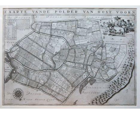
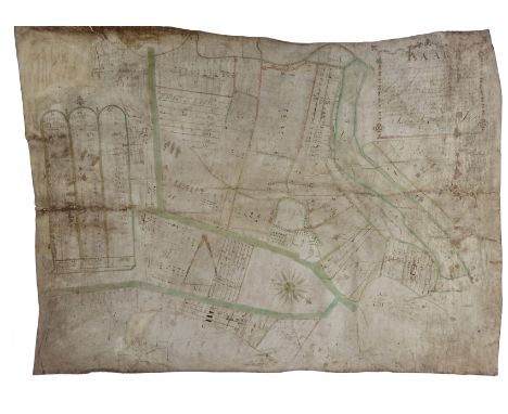
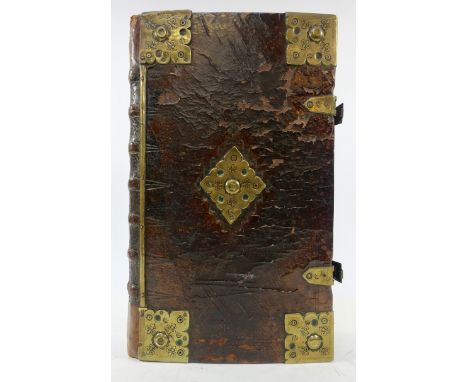
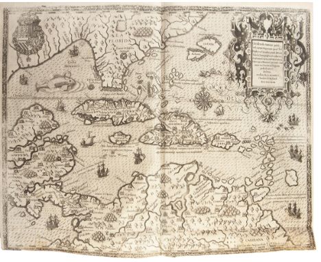
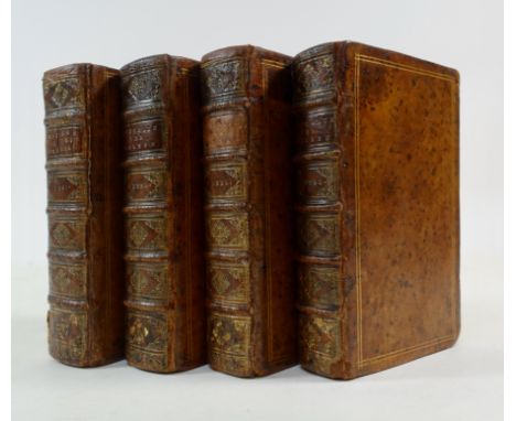
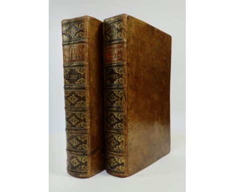
MARITIME HISTORY - TRAVELLING -- BRUYN (also BRUIN or BRUIJN), C. de. Reizen door de vermaardste Deelen van Klein Asia, De Eylanden Scio, Rhodus, Cyprus, Metelino, Stanchio, &c. Mitsgaders de voornaamste Steden van Ægypten, Syrien en Palestina. Delft, H. v. Krooneveld, 1698, (18), 398, (8) pp. W. engr. front. by Mulder, engr. portr. of the author by Gerrit Valck, 17 (the majority very large) fold. panoramic views, 26 fold./double-p. plates, 58 full-p. plates and 18 engr. in text. -- Id. Reizen over Moskovie, door Persie en Indie. Vertoonende De beroemste lantschappen en steden, ook de byzondere dragten, beesten, gewassen en planten, (…). Voor al derzelver oudheden, En wel voornamentlyk heel uitvoerig, die van het (…) Hof van Persepolis, By den Persiaenen Tchilminar genaemt. Amst., W. & D. Goeree, 1711. (8), 472, (12) pp. W. engr. front. by B. Picart, title in red and black, fine engr. portrait of the author by Gerrit Valck, 2 folding engr. maps, 11 fold. panoramic views, 54 double-p. plates, 44 full-p. plates and 36 engr. in text. -- 2 vols. Fol. Fine cont. full cf. w. raised bands, dec. gilt backs & brown labels. (Engr. map to the first vol. lacks (as often), small rep. to outer blank margin of first ti., a few o. small rep. and marginal tears, some fold. plates a bit creased, slightly browned/foxed in places, but a very fine set). NOTE:Cornelis de Bruyn (1652-1726 or 1727), Dutch portrait painter and traveller. In 1674 he decided to leave The Netherlands for Rome where he became a member of the Bentveughels, a company of Dutch and Flemish painters. After two and a half years in Rome he continued his journey in 1677 to the Near East. His voyages took him to Turkey, several Greek islands, Egypt, Palestine, Syria and Cyprus. In 1684 he travelled to Venice where he continued to work for eight years with the German painter Carlo Loth. In 1693 he returned to The Hague where he saw his 'Klein Asia' through the press. The large folded map lacks as often, because it was published later (see verso leaf ***). In 1701 he started this second journey which led him to Russia, Persia, India and Indonesia. In Russia he visited Archangelsk and the Samoyeds in North Russia. He was also commissioned to paint the cousins of Czar Peter with whom De Bruin also had a conversation in Dutch. In Persia he visited Persepolis and Ispahan. In 1705 he went to Ceylon and Java. The drawings he made, especially the large folding panoramic views of Moscow (30 x 190 cm), Ispahan (30 x 190 cm) and Persepolis (in 4 parts measuring in total 30 x 250 cm!), are very important because they are the first foreign representations of that kind and beautifully executed. - Tiele, 207 & 209; Drijvers, (e.a.). "Ik hadde de nieusgierigheid". De reizen door het Nabije Oosten v. C. de Bruijn (ca. 1652-1727); Cat. NHSM, p. 257; Cox I, 218 (on the first work): "One of the best illustrated works on the Levant".

Lot 2

BARTELS, M. Steden in scherven. Vondsten uit beerputten in Deventer, Dordrecht, Nijmegen en Tiel (1250-1900). (1999). 2 vols. 4°. Obrds. -- J.H. HOLWERDA. Arentsburg. Een Romeinsch militair vlootstation bij Voorburg. 1923. W. lge. fold. map (clumsily rep.) & 70 plates, partly fold. Fol. Or. clothbacked brds. -- J. BOGAERS. De Gallo-Romeinse tempels te Elst i.d. Over-Betuwe. 1955. Owrps. -- G. TICHELMAN. Het villacomplex Kerkrade-Holzkuil. (2005). 4°. Owrps. -- And 11 similar in Dutch. (16).

Lot 292

KLOOS, J. Noordwijk in den loop der eeuwen. Noordwijk, 1928. W. 94 illustr., 1 fold. map. & 1 fold. plan. 4°. Ocl. Fine copy, w. dedication by the author in rhyme. -- Added: F. LUGT. Het goed v. Oegstgeest. (2009). Obrds. -- And 2 o. (4).

Lot 303

LEIDEN -- POSTHUMUS, N.W. De geschied. v.d. Leidsche lakenindustrie. 's-Grav., 1908-39. 3 vols. W. fold. cold. map & 6 fold. tab. Cl. -- GEDENKBOEK NV. Electriciteits- & Gasmaatschappij voorh. De Vries & Stevens, 1868-1918. (±1918). W. 84 tipped in tinted photogr. within fine 'Art Nouveau' dec. borders des. by W. Meyer. 4°-obl. Or. dec. wrps. (Wrps. foxed/browned, a bit worn/w. small tears). -- (A.J. BACKER). Leidse wevers onder gaslicht. Schering & inslag. Van Zaalberg Dekens (1850-1915). (1952). Ohcl. -- C. SMIT. Ondernemers en geleerden, Leiden 1778-2003. 2003. 4°-obl. Obrds. -- And 12 o. (18).

Lot 304

LEIDEN -- SIEGE & RELIEF -- SEVERINUS, A. Oorspronckelijke beschrijving v.d. vermaerde belegering en 't ontzet der stad Leiden. 5e dr. Leyden, Wed. A. Honkoop & Zn, (1774). (16), 209, (3) pp. W. 5 engr. portrs. & 7 engr. plates. Old (worn) wrprs., uncut. -- J. FRUYTIERS. Korte beschryvinge v.d. strenge belegeringe en wonderbaarlyke verlossinge der stad Leiden in den jaare 1574. M. eenige aanteek. v. P. Scriverius. 1739. W. fold. engr. map. Sm-8°. Old wrps. (Remnants of glue at inner margin of beginning & end). -- CATALOGUS van oudheden en bijzonderheden, betreffende het beleg en ontzet der stad Leyden. (1824). Hcl. -- J. ROEMER. De oude Leidsche patroon, of Derden Octobers Banket. 1833. W. lithogr. ti. Owrps. (Wrps. a bit dam.). -- And 9 o. on the subject. (13).

Lot 316

JUBAYR, Ibn. The travels. Transl. by R.J.C. Broadhurst. (1952). W. 2 fold. maps. Ocl. w. dust-j. (Spine of dust-j. a bit browned/stained). -- C.M. DOUGHTY. Travels in Arabia Deserta. W. an introd. by T.E. Lawrence. New ed. (1936). W. lge-fold. map inserted in rear pocket. Ocl. w. dust-j. (Spine browned). -- J. WILSON. Lawrence of Arabia. The authorised biography. (1989). Obrds. w. dust-j. -- T.E. LAWRENCE. The letters. Ed. by D. Garnett. (1938). Ocl. -- And 1 o. (5).

Lot 342

KOREA -- ECKARDT, P.A. Geschichte der Koreanischen Kunst. Lpz., 1929. xxiii, 225, (1) pp. W. map and 506 ill. on 168 plates & 12 o. plates (4 cold.). Lge-8°. Ocl. (Slightly foxed).

Lot 545

RAILWAY INTEREST: 'CRUCHLEY'S NEW MAP' of Buckingham, pub. GF Cruchley, (undated, but inscribed 1887), and 'Walker's Kent' pub. Longmans 1835

Lot 556

A NEW MAP OF DORSETSHIRE BY WILLm TUNNICLIFF, 1791 (discoloured, torn, unframed)

Loading...Loading...
  • 109198 item(s)
    /page

Recently Viewed Lots